guide to outdoor activities 2009-2010 - South of France Tourism
guide to outdoor activities 2009-2010 - South of France Tourism
guide to outdoor activities 2009-2010 - South of France Tourism

You also want an ePaper? Increase the reach of your titles
YUMPU automatically turns print PDFs into web optimized ePapers that Google loves.
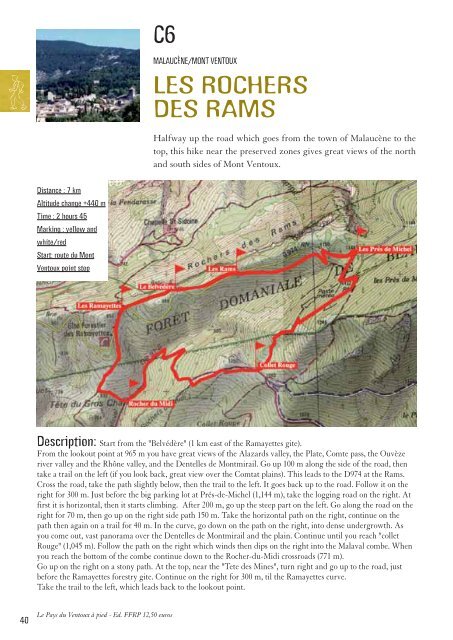
C6<br />
MALAUCÈNE/MONT VENTOUX<br />
LES ROCHERS<br />
DES RAMS<br />
Halfway up the road which goes from the <strong>to</strong>wn <strong>of</strong> Malaucène <strong>to</strong> the<br />
<strong>to</strong>p, this hike near the preserved zones gives great views <strong>of</strong> the north<br />
and south sides <strong>of</strong> Mont Ven<strong>to</strong>ux.<br />
Distance : 7 km<br />
Altitude change +440 m<br />
Time : 2 hours 45<br />
Marking : yellow and<br />
white/red<br />
Start: route du Mont<br />
Ven<strong>to</strong>ux point s<strong>to</strong>p<br />
Description: Start from the "Belvédère" (1 km east <strong>of</strong> the Ramayettes gite).<br />
From the lookout point at 965 m you have great views <strong>of</strong> the Alazards valley, the Plate, Comte pass, the Ouvèze<br />
river valley and the Rhône valley, and the Dentelles de Montmirail. Go up 100 m along the side <strong>of</strong> the road, then<br />
take a trail on the left (if you look back, great view over the Comtat plains). This leads <strong>to</strong> the D974 at the Rams.<br />
Cross the road, take the path slightly below, then the trail <strong>to</strong> the left. It goes back up <strong>to</strong> the road. Follow it on the<br />
right for 300 m. Just before the big parking lot at Prés-de-Michel (1,144 m), take the logging road on the right. At<br />
first it is horizontal, then it starts climbing. After 200 m, go up the steep part on the left. Go along the road on the<br />
right for 70 m, then go up on the right side path 150 m. Take the horizontal path on the right, continue on the<br />
path then again on a trail for 40 m. In the curve, go down on the path on the right, in<strong>to</strong> dense undergrowth. As<br />
you come out, vast panorama over the Dentelles de Montmirail and the plain. Continue until you reach "collet<br />
Rouge" (1,045 m). Follow the path on the right which winds then dips on the right in<strong>to</strong> the Malaval combe. When<br />
you reach the bot<strong>to</strong>m <strong>of</strong> the combe continue down <strong>to</strong> the Rocher-du-Midi crossroads (771 m).<br />
Go up on the right on a s<strong>to</strong>ny path. At the <strong>to</strong>p, near the "Tete des Mines", turn right and go up <strong>to</strong> the road, just<br />
before the Ramayettes forestry gite. Continue on the right for 300 m, til the Ramayettes curve.<br />
Take the trail <strong>to</strong> the left, which leads back <strong>to</strong> the lookout point.<br />
Le Pays du Ven<strong>to</strong>ux à pied - Ed. FFRP 12,50 euros<br />
40