Brochure ARVAPlant CE - ARVAtec
Brochure ARVAPlant CE - ARVAtec
Brochure ARVAPlant CE - ARVAtec

You also want an ePaper? Increase the reach of your titles
YUMPU automatically turns print PDFs into web optimized ePapers that Google loves.
GPS TECHNOLOGIES<br />
ADVAN<strong>CE</strong>D SYSTEMS<br />
INNOVATIVE SERVI<strong>CE</strong>S<br />
AGRICOLTURE<br />
ENVIRONMENT<br />
BUILDING<br />
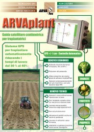
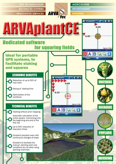
ARVAplant<strong>CE</strong><br />
Dedicated software<br />
for squaring fields<br />
Ideal for portable<br />
GPS systems, to<br />
facilitate staking<br />
and squares<br />
ECONOMIC BENEFITS<br />
Reduction of up to 50% of<br />
man work<br />
VINEYARDS<br />
Saving of staking time<br />
Optimization of the<br />
workforce<br />
TECHNICAL BENEFITS<br />
Staking without prior mapping<br />
Automatic calculation of the<br />
entire square, memorizing only<br />
the beginning and end of the<br />
fi rst row<br />
Up to 50% reduction of<br />
execution times<br />
Constant precision even with<br />
continuous changes of slope<br />
ORCHARDS<br />
POPLARS<br />
Excellent to facilitate the<br />
manual planting when soil<br />
conditions do not allow using<br />
planting machines<br />
HORTICULTURAL
MAIN COMPONENTS<br />
It can be installed on professional<br />
handhelds PDA with<br />
Windows Mobile operative system<br />
like MobileMapper TM 120.<br />
HOW ARVAPLANT<strong>CE</strong> WORKS<br />
ARVAplant<strong>CE</strong> Software is upgradeable<br />
always for free.<br />
Also available without PDA.<br />
Very easy to use.<br />
ARVACADplant optional offi ce<br />
software to project planting area<br />
and for report results.<br />
The complete version comes with the ARVAplant<strong>CE</strong> software<br />
portable GPS Mobile Mapper 120 RTK confi gured to work with<br />
+ /- 1 cm accuracy in real time. It can works connected to GPS<br />
network via GPRS or to a RTK base station via radio modem.<br />
After memorizing the start and end points A and B of the fi rst<br />
row, it calculates endlessly the squaring without fi rst mapping<br />
the perimeter of fi elds. Walking along the rows it indicates the<br />
position of the stakes and/or plants.<br />
Software Features<br />
• Can be installed on all<br />
portable GPS with Windows<br />
Mobile operative system<br />
• Alarm GPS accuracy<br />
• GPS antenna offset<br />
• Set different plant setting<br />
• Set tolerance of center<br />
points<br />
• Beep alarm at centering<br />
point<br />
• Double arrows guidance<br />
bars to facilitate the<br />
centering of the points<br />
• Possibility to work in both<br />
directions from A to B and<br />
from B to A<br />
• Line traslation features<br />
• Import allignements AB<br />
from office projects<br />
• Save / resume works<br />
BENEFITS<br />
ARVAplant<strong>CE</strong> permits the staking and squaring operations,<br />
reducing costs of execution time by 50%.<br />
DEALER