Workshop Proceedings - Inter Islamic Network on Space Sciences ...
Workshop Proceedings - Inter Islamic Network on Space Sciences ...
Workshop Proceedings - Inter Islamic Network on Space Sciences ...

Create successful ePaper yourself
Turn your PDF publications into a flip-book with our unique Google optimized e-Paper software.
Theme 1: Country Reports<br />
Applicati<strong>on</strong> of Remote Sensing for Agricultural Statistics: The Tunisian<br />
Experience<br />
Talhaoui Wafa, Haffani Myriam, Sghaier Nabil, Bacha Sinan, Sayah Najeh,<br />
Othmani Sofiane and Bouzguenda Neila<br />
Abstract<br />
M<strong>on</strong>itoring, estimating and forecasting of agricultural<br />
producti<strong>on</strong> are very important for managing the regi<strong>on</strong>al<br />
and local food security. Thus, it is necessary to have a<br />
powerful strategy for making agricultural statistics by the<br />
use of efficient tools. In this paper; we present the Tunisian<br />
experience in the use of remote sensing technologies for<br />
the estimati<strong>on</strong> of cereal areas, yield and producti<strong>on</strong>.<br />
and variability from the point of view of climate and cereal<br />
crop behavior as well as producti<strong>on</strong>.<br />
This paper shall present the methodology adopted and<br />
the results obtained in the estimati<strong>on</strong> of cereal areas,<br />
using three different approaches: The first approach<br />
adopts the Classificati<strong>on</strong> methods using SPOT images, the<br />
sec<strong>on</strong>d approachs uses statistical methods by means of<br />
vegetati<strong>on</strong> index extracted from Spot Vegetati<strong>on</strong> data and<br />
the third <strong>on</strong>e uses a statistical model.<br />
Introducti<strong>on</strong><br />
In Tunisia, cereal is <strong>on</strong>e of seven strategic agricultural<br />
products. Hence, it is an imperative need for policy makers<br />
to forecast early producti<strong>on</strong>s to engage the necessary<br />
provisi<strong>on</strong>s <strong>on</strong> cereal importati<strong>on</strong>, crop management,<br />
storage, processing, etc.. Thus, it is necessary to have a<br />
powerful strategy for making agricultural statistics by the<br />
use of efficient tools to enhance and improve the present<br />
statistical methods in the ministry of agriculture.<br />
Methodology<br />
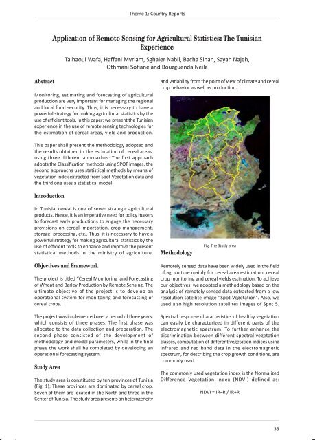
Fig. The Study area<br />
Objectives and Framework<br />
The project is titled “Cereal M<strong>on</strong>itoring and Forecasting<br />
of Wheat and Barley Producti<strong>on</strong> by Remote Sensing. The<br />
ultimate objective of the project is to develop an<br />
operati<strong>on</strong>al system for m<strong>on</strong>itoring and forecasting of<br />
cereal crops.<br />
The project was implemented over a period of three years,<br />
which c<strong>on</strong>sists of three phases: The first phase was<br />
allocated to the data collecti<strong>on</strong> and preparati<strong>on</strong>. The<br />
sec<strong>on</strong>d phase c<strong>on</strong>sisted of the development of<br />
methodology and model parameters, while in the final<br />
phase the work shall be completed by developing an<br />
operati<strong>on</strong>al forecasting system.<br />
Study Area<br />
The study area is c<strong>on</strong>stituted by ten provinces of Tunisia<br />
(Fig. 1); These provinces are dominated by cereal crop.<br />
Seven of them are located in the North and three in the<br />
Center of Tunisia. The study area presents an heterogeneity<br />
Remotely sensed data have been widely used in the field<br />
of agriculture mainly for cereal area estimati<strong>on</strong>, cereal<br />
crop m<strong>on</strong>itoring and cereal yields estimati<strong>on</strong>. To achieve<br />
our objectives, we adopted a methodology based <strong>on</strong> the<br />
analysis of remotely sensed data extracted from a low<br />
resoluti<strong>on</strong> satellite image “Spot Vegetati<strong>on</strong>”. Also, we<br />
used also high resoluti<strong>on</strong> satellites images of Spot 5.<br />
Spectral resp<strong>on</strong>se characteristics of healthy vegetati<strong>on</strong><br />
can easily be characterized in different parts of the<br />
electromagnetic spectrum. To further enhance the<br />
discriminati<strong>on</strong> between different spectral vegetati<strong>on</strong><br />
classes, computati<strong>on</strong> of different vegetati<strong>on</strong> indices using<br />
infrared and red band data in the electromagnetic<br />
spectrum, for describing the crop growth c<strong>on</strong>diti<strong>on</strong>s, are<br />
comm<strong>on</strong>ly used.<br />
The comm<strong>on</strong>ly used vegetati<strong>on</strong> index is the Normalized<br />
Difference Vegetati<strong>on</strong> Index (NDVI) defined as:<br />
NDVI = IR–R / IR+R<br />
33