Workshop Proceedings - Inter Islamic Network on Space Sciences ...
Workshop Proceedings - Inter Islamic Network on Space Sciences ...
Workshop Proceedings - Inter Islamic Network on Space Sciences ...

You also want an ePaper? Increase the reach of your titles
YUMPU automatically turns print PDFs into web optimized ePapers that Google loves.
Theme 2: Agriculture Landuse<br />
2.3. Method<br />
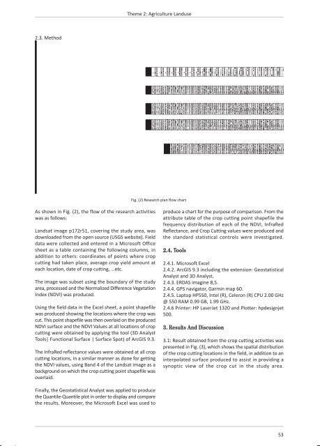
Fig. (2) Research plan flow chart<br />
As shown in Fig. (2), the flow of the research activities<br />
was as follows:<br />
Landsat image p172r51, covering the study area, was<br />
downloaded from the open source (USGS website). Field<br />
data were collected and entered in a Microsoft Office<br />
sheet as a table c<strong>on</strong>taining the following columns, in<br />
additi<strong>on</strong> to others: coordinates of points where crop<br />
cutting had taken place, average crop yield amount at<br />
each locati<strong>on</strong>, date of crop cutting, …etc.<br />
The image was subset using the boundary of the study<br />
area, processed and the Normalized Difference Vegetati<strong>on</strong><br />
Index (NDVI) was produced.<br />
Using the field data in the Excel sheet, a point shapefile<br />
was produced showing the locati<strong>on</strong>s where the crop was<br />
cut. This point shapefile was then overlaid <strong>on</strong> the produced<br />
NDVI surface and the NDVI Values at all locati<strong>on</strong>s of crop<br />
cutting were obtained by applying the tool (3D Analyst<br />
Tools| Functi<strong>on</strong>al Surface | Surface Spot) of ArcGIS 9.3.<br />
The InfraRed reflectance values were obtained at all crop<br />
cutting locati<strong>on</strong>s, in a similar manner as d<strong>on</strong>e for getting<br />
the NDVI values, using Band 4 of the Landsat image as a<br />
background <strong>on</strong> which the crop cutting point shapefile was<br />
overlaid.<br />
produce a chart for the purpose of comparis<strong>on</strong>. From the<br />
attribute table of the crop cutting point shapefile the<br />
frequency distributi<strong>on</strong> of each of the NDVI, InfraRed<br />
Reflectance, and Crop Cutting values were produced and<br />
the standard statistical c<strong>on</strong>trols were investigated.<br />
2.4. Tools<br />
2.4.1. Microsoft Excel<br />
2.4.2. ArcGIS 9.3 including the extensi<strong>on</strong>: Geostatistical<br />
Analyst and 3D Analyst.<br />
2.4.3. ERDAS imagine 8,5.<br />
2.4.4. GPS navigator, Garmin map 60.<br />
2.4.5. Laptop HP550, Intel (R), Celer<strong>on</strong> (R) CPU 2.00 GHz<br />
@ 550 RAM 0.99 GB, 1.99 GHz.<br />
2.4.6 Printer: HP LaserJet 1320 and Plotter: hpdesignjet<br />
500.<br />
3. Results And Discussi<strong>on</strong><br />
3.1: Result obtained from the crop cutting activities was<br />
presented in Fig. (3), which shows the spatial distributi<strong>on</strong><br />
of the crop cutting locati<strong>on</strong>s in the field, in additi<strong>on</strong> to an<br />
interpolated surface produced to assist in providing a<br />
synoptic view of the crop cut in the study area.<br />
Finally, the Geostatistical Analyst was applied to produce<br />
the Quantile-Quantile plot in order to display and compare<br />
the results. Moreover, the Microsoft Excel was used to<br />
53