Environmental Site Overview - East Hampton, Connecticut
Environmental Site Overview - East Hampton, Connecticut
Environmental Site Overview - East Hampton, Connecticut

Create successful ePaper yourself
Turn your PDF publications into a flip-book with our unique Google optimized e-Paper software.
SECTION 4 INITIAL ENVIRONMENTAL CONCERNS<br />
Tighe&Bond<br />
Historically, these were appealing reasons to make <strong>East</strong> <strong>Hampton</strong> the site of a new<br />
industrial center.<br />
The Air Line Railroad was built to connect Boston with New York City in virtually a<br />
straight line - the shortest route possible. The location of the route was drawn “through<br />
the air” via the city of New Haven. By 1873, this railroad was functioning from New<br />
Haven to Willimantic. At these points, the Air Line was able to link with other rail<br />
lines to connect New York and Boston in the shortest way possible. This railroad<br />
provided a means for the industries to receive supplies and to ship their products. The<br />
railroad traversed the Village Center in an east-west direction running parallel to<br />
Walnut Avenue. The area is now preserved as the Air Line Trail.<br />
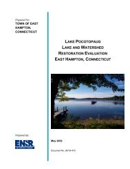
Pocotopaug Lake and Creek provided a convenient access to fresh water. This water<br />
was used as a means to generate electricity, cool industrial processes, and discharge<br />
waste. Within the last one-hundred years, the shape and volume of the Pocotopaug<br />
Creek has been altered. In particular, there were several ponds numbered sequentially<br />
from the north to the south. These ponds were joined by the Pocotopaug Creek. First<br />
Pond, as referenced on historic maps, is the location of Bevin Pond. The pond was<br />
expanded in 1860 with the building of a dam slightly north of the current Bevin<br />
Brothers location. Historic maps and aerial photographs indicate the volume of this<br />
pond has not been altered substantially since the 1860’s. Second Pond is located due<br />
east of 13 Summit Street. Historic maps and aerials indicate that the pond was much<br />
larger then it’s current volume. Third Pond was positioned at the corner of Summit<br />
Street and Watrous Street. The pond no longer exists and is currently the site of<br />
parking for 12 Summit Street. Review of an aerial photograph taken in 1934<br />
demonstrates the existence of the pond. Fourth Pond has also been completely drained.<br />
It formerly occupied a large area south of Walnut Street and east of Main Street.<br />
Examination of 1934 aerial photography indicated the pond had been substantially<br />
drained prior to that photograph.<br />
The majority of historic industrial development in <strong>East</strong> <strong>Hampton</strong> occurred along<br />
Pocotopaug Creek. To understand the historic industrial use of the Village Center it is<br />
necessary to reference them to current locations. However, many of the historic streets<br />
have been altered in name and location. Before discussing individual historic sites, it is<br />
necessary to clarify some of these discrepancies.<br />
• Abell Avenue was the name of the road that looped from Main Street to Summit<br />
Street. The street has since been divided into Walnut Avenue and Watrous<br />
Street.<br />
• Older Sanborn Historic Maps (1908) refer to Summit Street as Mill Street.<br />
• Bevin Court was formerly named Lake Street.<br />
Starr Place was formerly named Summit Avenue.<br />
<strong>Environmental</strong> <strong>Site</strong> <strong>Overview</strong> 4-4