Environmental Site Overview - East Hampton, Connecticut
Environmental Site Overview - East Hampton, Connecticut
Environmental Site Overview - East Hampton, Connecticut

Create successful ePaper yourself
Turn your PDF publications into a flip-book with our unique Google optimized e-Paper software.
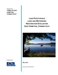
SECTION 4 INITIAL ENVIRONMENTAL CONCERNS<br />
Tighe&Bond<br />
the northeast corner of the building. The second floor was used for assembling. The<br />
third floor was used for plating and buffing. A stock house is located south of the<br />
river. This two-story storage facility kept wood shavings and boxing on the first floor<br />
with unknown storage on the second floor. The remaining building was a two-story<br />
brick office building and storeroom. This building was to the north and adjacent to<br />
Skinner Street. The power for the complex was listed as water and electric, the heat<br />
was provided by steam, lights by electricity, and power was provided by coal. There<br />
was a coal pile and iron storage area located near Pocotopaug Creek.<br />
The 1908 Sanborn Map details virtually the same features as the 1903. The name of<br />
the building has been changed to the Hardware and Woodenware Manufacturing<br />
Company N.N. Hill Brass Company Branch. After the dissolution of the National<br />
Novelty Corporation, many toy manufactures joined the Hardware and Woodenware<br />
Manufacturing Company. Similar to its predecessor, this consortium dissolved shortly<br />
after its creation. The 1925 Sanborn Map shows a virtually unchanged industrial<br />
complex. The name of the industry is now N.N. Hill Brass Company Manufacturer of<br />
Brass Goods. There is a building, located to the south of the Creek, dedicated to<br />
tumbling processes. Review of the 1934 aerial photograph shows the buildings as<br />
mostly the same configuration.<br />
4.4 ENVIRONMENTAL SETTING<br />
4.4.1 <strong>Site</strong> Geology/Hydrogeology<br />
The United States Geological Survey Surficial Materials Map of <strong>Connecticut</strong> (Stone, et<br />
al, 1992) indicates the surficial geology of the quadrangle is composed of thin till. This<br />
is described as areas where till is generally less than 1-10 feet thick and including areas<br />
of bedrock outcrop where till is absent. The upper till is loose to moderately compact,<br />
generally sandy, and commonly stony.<br />
According to the USGS Bedrock Geological Map of <strong>Connecticut</strong> (Rogers, 1985), the<br />
bedrock is classified as Brimfield Schists. The bedrock type consists of a gray, rusty<br />
weathering, medium to coarse grained, interlayered schists and gneiss. Schists are<br />
described as light silvery to dark, coarse to very coarse grained, strong to very strongly<br />
layered metamorphic rock, whose layering is typically defined by parallel alignment of<br />
micas. Primarily composed of mica, quartz, and feldspar; occasionally spotted with<br />
conspicuous garnets. Gneiss are described as light and dark, medium to coarse-grained<br />
metamorphic rock characterized by compositional banding of light and dark minerals,<br />
typically composed of quartz feldspar, and various amounts of dark minerals; occurs<br />
with a variety of compositions and is a characteristic of the uplands. The depth of the<br />
bedrock ranges from 55 to 65 feet.<br />
<strong>Environmental</strong> <strong>Site</strong> <strong>Overview</strong> 4-11