

Karnataka - Ministry of Environment and Forests
Karnataka - Ministry of Environment and Forests
Karnataka - Ministry of Environment and Forests

You also want an ePaper? Increase the reach of your titles
YUMPU automatically turns print PDFs into web optimized ePapers that Google loves.
7.1.15 Shimoga<br />
Shimoga district is situated in the western part <strong>of</strong> <strong>Karnataka</strong> State <strong>and</strong> lies between latitudes 13°27’00’’ to<br />
14°39’00’’ N <strong>and</strong> longitudes 74°38’00’’ to 76°04’00’’ E with a geographical area <strong>of</strong> 8465 sq km. The district is<br />
blessed with surface drainage system formed by Tunga, Bhadra, Tungabhadra, Varda, D<strong>and</strong>avathy,<br />
Kumudavathy, Varahi <strong>and</strong> Sharavati rivers. The district has Linganamakki reservoir, Gajnur dam, Chakra<br />
reservoir <strong>and</strong> the renowned Jogfalls. Agumbe is the place that is known to receive the highest rain fall in the<br />
state is also located in this district. M<strong>and</strong>agadde <strong>and</strong> Gudavi bird sanctuaries are located in this district.<br />
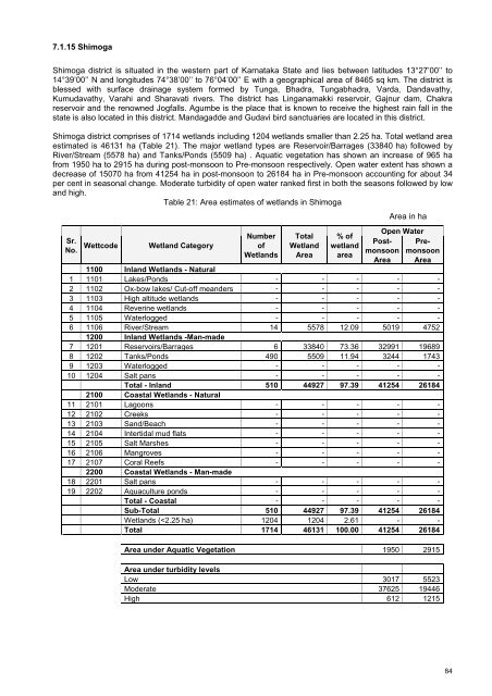
Shimoga district comprises <strong>of</strong> 1714 wetl<strong>and</strong>s including 1204 wetl<strong>and</strong>s smaller than 2.25 ha. Total wetl<strong>and</strong> area<br />
estimated is 46131 ha (Table 21). The major wetl<strong>and</strong> types are Reservoir/Barrages (33840 ha) followed by<br />
River/Stream (5578 ha) <strong>and</strong> Tanks/Ponds (5509 ha) . Aquatic vegetation has shown an increase <strong>of</strong> 965 ha<br />
from 1950 ha to 2915 ha during post-monsoon to Pre-monsoon respectively. Open water extent has shown a<br />
decrease <strong>of</strong> 15070 ha from 41254 ha in post-monsoon to 26184 ha in Pre-monsoon accounting for about 34<br />
per cent in seasonal change. Moderate turbidity <strong>of</strong> open water ranked first in both the seasons followed by low<br />
<strong>and</strong> high.<br />
Table 21: Area estimates <strong>of</strong> wetl<strong>and</strong>s in Shimoga<br />
Number<br />
Sr.<br />
No. Wettcode Wetl<strong>and</strong> Category <strong>of</strong><br />
Wetl<strong>and</strong>s<br />
Total<br />
Wetl<strong>and</strong><br />
Area<br />
% <strong>of</strong><br />
wetl<strong>and</strong><br />
area<br />
Area in ha<br />
Open Water<br />
Postmonsoon<br />
Area<br />
Premonsoon<br />
Area<br />
1100 Inl<strong>and</strong> Wetl<strong>and</strong>s - Natural<br />
1 1101 Lakes/Ponds - - - - -<br />
2 1102 Ox-bow lakes/ Cut-<strong>of</strong>f me<strong>and</strong>ers - - - - -<br />
3 1103 High altitude wetl<strong>and</strong>s - - - - -<br />
4 1104 Reverine wetl<strong>and</strong>s - - - - -<br />
5 1105 Waterlogged - - - - -<br />
6 1106 River/Stream 14 5578 12.09 5019 4752<br />
1200 Inl<strong>and</strong> Wetl<strong>and</strong>s -Man-made<br />
7 1201 Reservoirs/Barrages 6 33840 73.36 32991 19689<br />
8 1202 Tanks/Ponds 490 5509 11.94 3244 1743<br />
9 1203 Waterlogged - - - - -<br />
10 1204 Salt pans - - - - -<br />
Total - Inl<strong>and</strong> 510 44927 97.39 41254 26184<br />
2100 Coastal Wetl<strong>and</strong>s - Natural<br />
11 2101 Lagoons - - - - -<br />
12 2102 Creeks - - - - -<br />
13 2103 S<strong>and</strong>/Beach - - - - -<br />
14 2104 Intertidal mud flats - - - - -<br />
15 2105 Salt Marshes - - - - -<br />
16 2106 Mangroves - - - - -<br />
17 2107 Coral Reefs - - - - -<br />
2200 Coastal Wetl<strong>and</strong>s - Man-made<br />
18 2201 Salt pans - - - - -<br />
19 2202 Aquaculture ponds - - - - -<br />
Total - Coastal - - - - -<br />
Sub-Total 510 44927 97.39 41254 26184<br />
Wetl<strong>and</strong>s (


