

Karnataka - Ministry of Environment and Forests
Karnataka - Ministry of Environment and Forests
Karnataka - Ministry of Environment and Forests

Create successful ePaper yourself
Turn your PDF publications into a flip-book with our unique Google optimized e-Paper software.
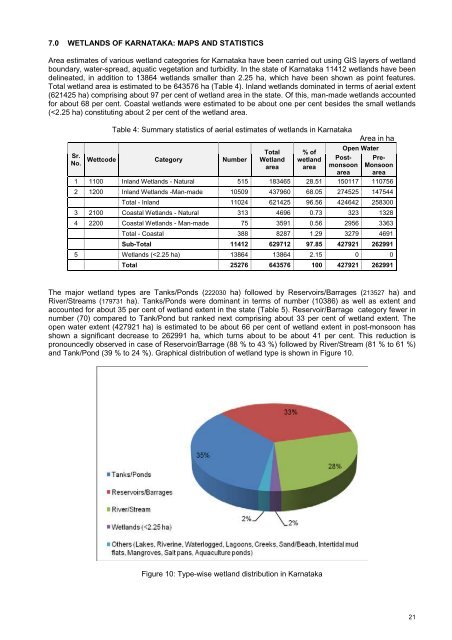
7.0 WETLANDS OF KARNATAKA: MAPS AND STATISTICS<br />
Area estimates <strong>of</strong> various wetl<strong>and</strong> categories for <strong>Karnataka</strong> have been carried out using GIS layers <strong>of</strong> wetl<strong>and</strong><br />
boundary, water-spread, aquatic vegetation <strong>and</strong> turbidity. In the state <strong>of</strong> <strong>Karnataka</strong> 11412 wetl<strong>and</strong>s have been<br />
delineated, in addition to 13864 wetl<strong>and</strong>s smaller than 2.25 ha, which have been shown as point features.<br />
Total wetl<strong>and</strong> area is estimated to be 643576 ha (Table 4). Inl<strong>and</strong> wetl<strong>and</strong>s dominated in terms <strong>of</strong> aerial extent<br />
(621425 ha) comprising about 97 per cent <strong>of</strong> wetl<strong>and</strong> area in the state. Of this, man-made wetl<strong>and</strong>s accounted<br />
for about 68 per cent. Coastal wetl<strong>and</strong>s were estimated to be about one per cent besides the small wetl<strong>and</strong>s<br />
(


