Downloaded - Ikon Science
Downloaded - Ikon Science
Downloaded - Ikon Science

Create successful ePaper yourself
Turn your PDF publications into a flip-book with our unique Google optimized e-Paper software.
SPECIAL Africa SECTION: Africa<br />
<br />
<br />
RICHARD SWARBRICK, STEPHEN O’CONNOR, and RICHARD LAHANN, IKON-GeoPressure<br />
High-pressure sediments in which oil and gas are generated<br />
and accumulate in traps are proven in many operating<br />
areas along the entire West African margin. Although classic<br />
areas for high pressure are found in Tertiary deltas, such as<br />
the Niger Delta, other types of basins in which young clastic<br />
sediments have accumulated also create the environment<br />
for high pressure and drilling challenges. The BP Macondo<br />
oil spill in the Gulf of Mexico has highlighted the technical<br />
challenge of drilling for oil in deep water, and the high<br />
pressures there added complexity to the control incident and<br />
the high volumes of fluids which blew out to the seabed.<br />
Understanding mechanisms which create high pressure,<br />
the context for pressure prediction, using all available data<br />
including seismic, and quantifying uncertainty are all required<br />
for successful, safe drilling in these challenging subsurface<br />
environments. Where there are many well penetrations<br />
with appropriate data, compilation of relevant data and<br />
their analysis within an integrated basin-scale pressure study<br />
allows the whole area to be contextualized for pressure. Such<br />
studies have been completed in Europe and North America,<br />
but along the West African margin so far only in the Niger<br />
Delta (Offshore, 2010), providing understanding of pressure<br />
distributions in the main reservoirs as well as relationships<br />
concerning seal breach and lateral drainage.<br />
This article places into context the reasons why and where<br />
high pressures are expected in drilling operations along the<br />
West African Margin and focuses on the challenges. Particular<br />
attention is paid to the Niger Delta where a major new regional<br />
initiative, in conjunction with DPR and NAPIMS and<br />
industry sponsors in Nigeria, is leading the way in regional<br />
interpretation of pressures leading to reduced drilling risk as<br />
well as new exploration opportunities.<br />
Why high pressure?<br />
High pressures are typically found in young, rapidly deposited<br />
clastic rocks (mainly sandstones, shales, siltstones)<br />
because of incomplete dewatering of the fine-grained rocks<br />
such as shales. This process is known as compaction disequilibrium<br />
(hence the more shale in the sedimentary succession<br />
the more the likelihood of high pressure). The amount of<br />
excess pressure (called overpressure) is a function of the permeability<br />
of the rocks (how fast the water can escape when<br />
buried) and the rate of burial. GeoPressure Technology has<br />
established an exclusive relationship between sedimentation<br />
rate and amount of overpressure for silty and shale-rich rocks,<br />
calibrated against a worldwide data set, which offers an early<br />
model of overpressure magnitude for predrill planning in<br />
these types of settings. However, there are other reasons for<br />
high pressure which are related mainly to deeper processes<br />
taking place in the rock column, at elevated temperatures.<br />
Gas generation is one of these mechanisms, creating pressure<br />
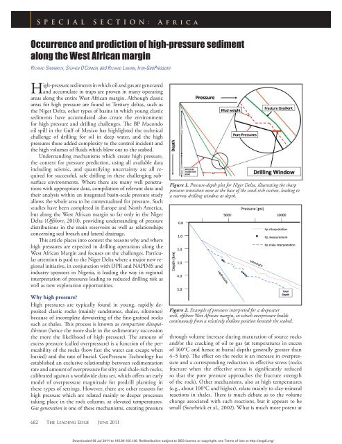
Figure 1. Pressure-depth plot for Niger Delta, illustrating the sharp<br />
pressure-transition zone at the base of the sand-rich section, leading to<br />
a narrow drilling window at depth.<br />
Figure 2. Example of pressures interpreted for a deepwater<br />
well, offshore West African margin, in which overpressure builds<br />
continuously from a relatively shallow position beneath the seabed.<br />
through volume increase during maturation of source rocks<br />
and/or the cracking of oil to gas (at temperatures in excess<br />
of 160°C and hence at burial depths generally greater than<br />
4–5 km). The effect on the rocks is an increase in overpressure<br />
and a corresponding reduction in effective stress (rocks<br />
fracture when the effective stress is significantly reduced<br />
so that the pore pressure approaches the fracture strength<br />
of the rock). Other mechanisms, also at high temperatures<br />
(e.g., about 100°C and higher), relate mainly to clay-mineral<br />
reactions in shales. There is much debate as to the volume<br />
change associated with such reactions, but it appears to be<br />
small (Swarbrick et al., 2002). What is much more potent at<br />
682 The Leading Edge June 2011<br />
<strong>Downloaded</strong> 08 Jul 2011 to 195.99.165.130. Redistribution subject to SEG license or copyright; see Terms of Use at http://segdl.org/
Africa<br />
creating pressure is the collapse of the rock’s load-supporting<br />
framework (load transfer), potentially leading to high<br />
overpressures. Other mechanisms, believed to be minor in<br />
amount of overpressure generated, relate to water expansion<br />
on heating (aquathermal), selected mineral dehydration<br />
reactions and osmosis (where salinity differences are found).<br />
However, one or more of these other mechanisms can add to<br />
the overpressure already created by compaction disequilibrium<br />
and push the pressures toward the fracture pressure and<br />
tensile failure (a condition known as seal breach). In summary,<br />
multiple mechanisms are possible. The most effective<br />
is rapid burial of fine-grained rocks (when overpressure can<br />
commence within a few hundred meters of the sea-bed), but<br />
in deeper, hotter rocks many other mechanisms can add additional<br />
overpressure.<br />
<br />
Where does high pressure occur?<br />
It follows from the above description of the mechanisms that<br />
three main components control where overpressures occur:<br />
rate of sediment burial, temperature, and sediment permeability.<br />
Areas of high sedimentation rate will normally correlate,<br />
along a continental margin such as offshore West Africa,<br />
with high sediment input. Big river systems depositing<br />
large volumes of suspended sediment at their deltas are the<br />
most likely locations, the most visible of which are the Niger<br />
and Congo rivers exiting into the South Atlantic. The Niger<br />
Delta sediments are a mixture of sandstone (reservoirs) and<br />
shales (seals), deposited over time in a complex pattern of<br />
distributary systems running across the delta top, across the<br />
shoreface and into offshore deepwater environments where<br />
they interbed with marine sediments, largely shales. Tertiary<br />
deltas such as these typically exhibit a high sand content on<br />
the shelf and delta top, leading to near normal pressure conditions<br />
down to depths of 3000 m+ (10,000 ft), below which<br />
a sharp increase in overpressure (a rapid pressure-transition<br />
zone, Figure 1) leads to several drilling challenges. Firstly,<br />
the start of a rapid buildup in overpressure can be difficult<br />
to predict if the pressure change is accompanied by a facies<br />
change. Secondly, the rate of pressure increase can be high.<br />
In Brunei, for example, an increase in overpressure of 220<br />
bar (3200 psi) is reported (Ellenor, 1984) across a shale only<br />
17 m (55 ft) thick. Dickinson (1953) reports a > 230 bar<br />
(3300 psi) increase in overpressure over a 60-m vertical section<br />
at the base of the sand-rich facies in the Gulf of Mexico.<br />
Finally, the increase in overpressure can lead to a narrow<br />
drilling window (difference between pore pressure and fracture<br />
gradient, Figure 1). All these issues need to be assessed<br />
predrill and captured in the well-planning process for most<br />
likely and high-case pressure predictions and optimal positioning<br />
of casing to maintain wellbore stability, drilling<br />
safety, and minimize potential rig downtime.<br />
Further seaward, and especially down the continental<br />
slope, the sediments become more mud-rich and any sand<br />
reservoirs are confined to channel and fan systems, most likely<br />
enclosed in low-permeability shales. The pressure profile<br />
in more continuous shale sections is one of constant increase<br />
in overpressure, often with a gradient running parallel to the<br />
June 2011 The Leading Edge 683<br />
<strong>Downloaded</strong> 08 Jul 2011 to 195.99.165.130. Redistribution subject to SEG license or copyright; see Terms of Use at http://segdl.org/
Africa<br />
overburden (Figure 2). From a drilling perspective, the rate of<br />
increase along the pressure-transition zone is gradual with less<br />
probability of a drilling surprise. However, the start of overpressure<br />
at relatively shallow depths of burial, typically 1000<br />
m (3000 ft) below seabed, leads to a long and continuous<br />
narrow drilling window, requiring frequent casing strings to<br />
maintain borehole integrity. Some wells along the continental<br />
margin of West Africa have had to set total depth prior to<br />
reaching all their expected targets because of these extensive<br />
pressure-transition zones.<br />
Thermal processes will occur at depths where the temperatures<br />
allow selected reactions in suitable rocks. Source rocks<br />
are required for gas generation and the overpressure generated<br />
with the source rock will, over geological time, influence other<br />
sediments both above and below. Similarly, clay-mineral<br />
reactions occur when the kinetics (time and temperature conditions<br />
for reaction) are met at depth. Once a single reaction<br />
has occurred, no further overpressure will be generated unless<br />
other reactions occur. Detailed knowledge of clay-mineral<br />
diagenesis remains relatively elusive.<br />
How do we predict high pressure?<br />
Traditionally, the method to predict the pressure of shale-rich<br />
rocks is to analyze seismic and well data, working with the<br />
principles that (a) high pressure is associated with higher than<br />
expected porosity; (b) the parameter used to capture porosity<br />
is of good quality with high data density; and (c) the only<br />
reason for the overpressure is compaction disequilibrium. The<br />
two main relationships used to quantify pore pressure are the<br />
(a) Eaton ratio method, an empirical approach in which Eaton<br />
provided constants for sonic velocity, resistivity and drilling<br />
exponent (Dxc) data, and (b) equivalent depth method, a<br />
deterministic approach, which is most commonly used with<br />
density and sonic velocity data. Ideally, pore-pressure prediction<br />
practitioners will use both methods applied to several data<br />
types to compare prediction profiles. In that way a measure<br />
of the uncertainty in the prediction can be usefully assessed.<br />
In Figure 3, four types of log data (sonic, density, neutron,<br />
and resistivity) have been used from a single well to estimate<br />
the pressures in a thick shale section. In this example, from<br />
offshore West Africa, there is good consistency of patterns of<br />
pressure estimation in the shales using all four log types. Because<br />
shale pressure cannot be independently verified, except<br />
in shallow sediments (< 200 m burial), it is imperative to build<br />
confidence of the overpressure magnitude, because drilling<br />
any sediments with high permeability will lead to a wellbore<br />
influx (potential kick) if the mud weight is not high enough to<br />
balance the formation fluid pressures. High confidence comes<br />
with consistency of results, combined with understanding the<br />
reservoirs and their relation to interbedded shales (and other<br />
lithologies). Isolated reservoirs often share similar overpressures<br />
with surrounding shales (good calibration to shale-based<br />
models), whereas interconnected reservoirs can allow pressure<br />
transfer leading to both higher and lower pressures than the<br />
surrounding shales (poor calibration for shale-based models).<br />
Laterally drained reservoirs in which reservoir pressures are<br />
significantly lower than the shales above and below are known<br />
along the West African margin. The thick reservoir in Figure<br />
3 has lower overpressure (from direct pressure measurements<br />
or MDTs) than the shales above, an indication of a laterally<br />
drained reservoir.<br />
Pressure prediction becomes more challenging and uncertain<br />
where pressure-generating mechanisms other than<br />
compaction disequilibrium are contributing to the overpressure<br />
and assessing which mechanisms may be contributors<br />
could benefit from plotting velocity against density, coded to<br />
depth (Chopra and Huffman, 2006). Figure 4 shows a schematic<br />
plot to illustrate trends of data with depth (arrows are<br />
from shallow to deep) to capture compaction disequilibrium,<br />
unloading (Bowers, 1994) associated with fluid expansion,<br />
such as gas generation, and the range of responses associated<br />
with chemical change in shales. The results of the plot help<br />
to guide the adaptation of the traditional approach to prediction,<br />
such as changes to the Eaton exponent, or application of<br />
a Bowers unloading model (Bowers, 1995). The confidence<br />
of any prediction in which multiple mechanisms are active<br />
is lower than for disequilibrium compaction alone, and careful<br />
calibration to any direct pressure measurements in offset<br />
wells becomes more critical. In addition, the effectiveness of<br />
seismic-based pore-pressure prediction (well suited to locations<br />
situated far from available well data) can be severely reduced.<br />
From a predrill prediction point of view, the inability<br />
to anticipate contributions to overpressure from fluid expansion<br />
and chemical processes and the associated modification<br />
of the rock properties used for pressure profiling can lead to<br />
substantial underprediction of reservoir pressures and hence<br />
add substantial risk to the safety of well operations. Realistic<br />
uncertainty estimates are important at this stage.<br />
Regional pressure studies<br />
Offset well data must always be examined carefully as the<br />
main calibration data for pressure prediction in undrilled areas.<br />
Where sufficient density of wells is available, compilation<br />
of the data basin-wide offers immense advantages. Successful<br />
Figure 3. Example of pressure-depth plot for a thick shale interval<br />
in which pressure is estimated from four log types (sonic, density,<br />
resistivity, and neutron). The reservoir beneath has lower overpressures<br />
on account of lateral drainage (see text).<br />
684 The Leading Edge June 2011<br />
<strong>Downloaded</strong> 08 Jul 2011 to 195.99.165.130. Redistribution subject to SEG license or copyright; see Terms of Use at http://segdl.org/
Africa<br />
pressure prediction does not only rely on local rock property<br />
data (such as porosity from velocity, density, or resistivity)<br />
coupled with direct pressure data from offset wells, but also<br />
must correspond to a realistic model for the development and<br />
distribution of basin fluids in the subsurface over geological<br />
time. Commercial fully coupled basin-flow modeling software<br />
offers a way to gain insights into fluid-flow behavior<br />
during progressive sedimentation, burial, and the influences<br />
of temperature. Basin models are particularly well suited<br />
where seismic definition is poor (for example under salt).<br />
However, they are not instantly available; building a model<br />
for an area of 100 km 2 is likely to take 3–4 weeks with the<br />
same amount of time to test and migrate from 1D through<br />
2D to 3D. GeoPressure Technology is currently interpreting<br />
the deepwater and ultra-deepwater areas of the Niger Delta.<br />
The outcome will be a set of maps and plots which describes<br />
the distribution of overpressure in all the main reservoirs and<br />
their relationship with each other. Each well has been examined<br />
not only for direct pressure data, but also for its relationship<br />
with shale pressures from a standard pressure-prediction<br />
interpretation (after testing for which mechanisms are active<br />
geographically and varying with depth and temperature).<br />
The entire data package provides a unique description of the<br />
subsurface plumbing of the Niger Delta. In addition, the<br />
data are rich enough for basin-wide compaction, overburden,<br />
and fracture-gradient algorithms to be generated and then<br />
tested. The deepwater Niger Delta project will be completed<br />
in the second quarter of 2011, after which other areas of the<br />
Niger Delta will be the prime focus. In addition to reduced<br />
risk (better definition of the drilling window based on both<br />
pore-pressure and fracture-pressure prediction), the description<br />
of the subsurface pressure relationship benefits exploration<br />
in areas such as seal breach risk (top seal failure prediction)<br />
as well as potential trap definition associated with fault<br />
sealing. Other areas of the West African margin which could<br />
benefit from regional or semiregional pressure studies of this<br />
nature include offshore Mauritania, Ghana, Angola, Gabon,<br />
and Cameroon.<br />
<br />
Regional informs the local<br />
Understanding the bigger picture through regional pressure<br />
studies (as done in Europe, the USA, and West Africa, for<br />
example) helps to improve prediction from local data as well<br />
as increase understanding of rock and fluid properties and<br />
distribution. Two direct applications are cited here, both of<br />
which apply to West Africa exploration. Mapping of overpressure<br />
and recognition of pressure compartments related<br />
to faults help to establish which faults preferentially leak and<br />
which seal, adding confidence to the search for downthrown<br />
fault traps. If higher overpressure exists on the upthrown<br />
side (Figure 5a), then prospectivity is enhanced (i.e., the trap<br />
is more likely to be successful). Where the opposite is true<br />
(Figure 5b, higher pressure on the downthrown side), then<br />
the prospect has a lower chance of trapping hydrocarbons.<br />
Pressure analysis then becomes part of the risking strategy<br />
associated with the trap. In the same way, top seal failure can<br />
be assessed by examining the relationship between the pore<br />
June 2011 The Leading Edge 685<br />
<strong>Downloaded</strong> 08 Jul 2011 to 195.99.165.130. Redistribution subject to SEG license or copyright; see Terms of Use at http://segdl.org/
Africa<br />
pressure expected in the reservoir and seal, and the fracture<br />
strength of the top seal (see recent examples from the North<br />
Sea in Swarbrick et al., 2010).<br />
Another direct exploration benefit relating to understanding<br />
regional pressures occurs where reservoirs are connected<br />
over a large area and communicate to the surface, thereby<br />
drawing down the deeper reservoir overpressures relative to<br />
their intraformational shales. These conditions are known in<br />
the North Sea and South Caspian basins and similar geological<br />
conditions are found along the West African margin (Figure<br />
3). The lateral drainage from these reservoirs sets up a hydrodynamic<br />
flow through the reservoir over geological time.<br />
The changes of overpressure resulting from lateral drainage<br />
can be mapped. The map can be used to indicate the amount<br />
and direction of tilt of hydrocarbon-water contacts along the<br />
base of the hydrocarbons trapped above the hydrodynamic<br />
reservoir. Tilt depends on overpressure differences as well as<br />
the density contrast between hydrocarbons and water: the<br />
lighter the oil or gas the less the tilt. Examination of amplitude<br />
anomalies and their relationship with structure can<br />
improve confidence of assessing hydrodynamic trapping and<br />
the location and potential size of reserves.<br />
Pressures along the West African margin<br />
The geology of the West African continental margin is dominated<br />
by clastic sediments, which are therefore prone to the<br />
development of overpressures. Deeply buried sediments,<br />
mainly of Jurassic/Cretaceous age, include some of the main<br />
source rocks which make the margin a hugely successful petroleum<br />
province. Continuous Tertiary sedimentation has<br />
provided some world-class reservoirs but also significant sediment<br />
accumulation rates in which high overpressure is not<br />
uncommon. While the Niger Delta is the most well-known<br />
for its association with rapid sedimentation and overpressure,<br />
the signature of high pressure extends throughout the margin.<br />
The degree of overpressuring, and the location of narrow<br />
drilling margins both geographically and stratigraphically,<br />
varies. The shallowest overpressure is found down the<br />
continental slope (i.e., in the deepwater environments, where<br />
clay-rich sediments are at their finest-grained and have low<br />
permeability, even at shallow burial depths). A main challenge<br />
in drilling in such locations is that in deep water it is<br />
desirable to drill without a riser to set a deep conductor pipe<br />
to optimize well control later in the well. If overpressured<br />
reservoirs are drilled without a riser, there is a reduced capability<br />
to handle a well flow. Shallow-water flows are a feature<br />
of deepwater drilling in such environments and can be costly.<br />
Overpressure in shallow reservoirs is difficult to predict prior<br />
to drilling. (Note that shallow-water flows can also occur<br />
naturally and do not cause environmental damage.)<br />
In mud and shale-dominated sediments, overpressure continues<br />
to build with depth, and can lead to drilling challenges<br />
when the drilling window is long and narrow, requiring many<br />
casing strings (and hence high cost) to maintain well integrity.<br />
In regions, such as the Niger Delta, where the upper section of<br />
the sedimentary column has a high proportion of sand, the onset<br />
of overpressure is deeper, but the rate of overpressure buildup<br />
Figure 4. Trends of velocity versus depth which reveal patterns<br />
associated with the main processes which generate overpressure.<br />
Figure 5. Both (a) and (b) show overpressure differences on either<br />
side of a downthrown fault trap. (a) The lower overpressure on the<br />
downthrown side enhances trapping potential. (b) Higher overpressure<br />
on the downthrown side downgrades trapping potential, as updip,<br />
cross-fault flow is more likely.<br />
(the pressure-transition zone) is much more rapid, leading to<br />
drilling challenges. However, where clastic sediments anywhere<br />
along the West African margin are at temperatures < 100°C,<br />
there can be moderate-to-high confidence in pore-pressure prediction<br />
from shale properties using traditional approaches to<br />
well and seismic data. The principal challenges come with data<br />
quality, with the geology of reservoir distribution and connectivity,<br />
and the presence of other rock types, such as salt.<br />
686 The Leading Edge June 2011<br />
<strong>Downloaded</strong> 08 Jul 2011 to 195.99.165.130. Redistribution subject to SEG license or copyright; see Terms of Use at http://segdl.org/
Africa<br />
A more challenging predrill prediction environment occurs<br />
at depths at which temperatures exceed a threshold where<br />
thermal processes can create additional overpressure as well<br />
as change sediment properties used in routine approaches to<br />
pressure prediction. The deeply buried Jurassic/Cretaceous<br />
source rocks along the West African margin, in particular at<br />
temperatures in excess of 160°C, are prone to generate gas.<br />
Gas requires a higher volume than oil or water and hence increases<br />
the pressure on generation. Increases in pressure reduce<br />
the effective stress (the difference between the pore fluid pressure<br />
and the minimum stress required to fracture the rock), a<br />
sediment property used in pore-pressure prediction. There is<br />
a tendency to underpredict pore pressures if this effect is not<br />
recognized. Similarly, at temperatures in excess of 100–120°C,<br />
there are many processes, for typical burial rates, which modify<br />
shale properties (such as clay-mineral transformation of<br />
smectite to illite) that once again challenge the premises used<br />
to estimate pore pressures ahead of the bit. In areas, such as<br />
offshore Angola, where thick and sometimes mobile salt is<br />
present, pore pressures can be extremely difficult to predict,<br />
because seismic imaging is poor, both for structure and the<br />
velocities used in predrill prediction techniques. The amount<br />
of pressure found beneath salt largely depends on the extent<br />
of the salt as a rock unit and the ability of the salt to trap fluid<br />
beneath. Fluids can escape where salt is absent if there are sufficient<br />
volumes of connected reservoirs to allow high-pressure<br />
fluids to flow around the salt bodies.<br />
Summary<br />
Continental margins are characterized by geological conditions<br />
that favor development of high-pressure reservoirs, except<br />
where there is an overabundance of reservoirs, such as<br />
in the Niger Delta. Even here, deeply buried reservoirs can<br />
have extremely high pressures. There are multiple overpressure<br />
mechanisms operating simultaneously both in the shallow<br />
section (inability of water to escape from rapidly buried, finegrained<br />
sediments) and in the deep section (gas generation and<br />
changes in sediment fabric because of diagenesis). In all cases,<br />
the pressures found in reservoirs are closely related to the connectivity<br />
of reservoirs both vertically and laterally along and<br />
down the margin. High connectivity permits fluids to escape,<br />
while isolated reservoirs will maintain the pressures being generated<br />
in the surrounding fine-grained rocks. Regional mapping<br />
of overpressures along the West African margin, as being<br />
done in the current Niger Delta pressure study, has the potential<br />
to reduce drilling risk by illustrating pressure distributions<br />
as well as reducing the exploration risk associated with trapping,<br />
both conventional and hydrodynamic.<br />
References<br />
Bowers, G. L., 1994, Pore pressure estimation from velocity data: accounting<br />
for overpressure mechanisms besides undercompaction:<br />
SPE paper 27488.<br />
Bowers, G. L., 1995, Pore pressure estimation from velocity data:<br />
Accounting for overpressure mechanisms besides undercompaction:<br />
SPE Drilling and Completion, 10, no. 2, 89–95,<br />
doi:10.2118/27488-PA.<br />
Chopra, S. and A. Huffman, 2006, Velocity determination for pore<br />
pressure prediction: CSEG Recorder, April 2006, 28–46.<br />
Dickenson, G., 1953, Geological aspects of abnormal reservoir pressures<br />
in Gulf Coast Louisiana: AAPG Bulletin, 37, 410–432.<br />
Ellenor, D. W., 1984, quoted in The geology and hydrocarbon resources<br />
of Negara Brunei Darussalam: Brunei Shell Petroleum<br />
Company.<br />
Pressure study for Nigeria, Offshore, 2010, http://www.offshore247.<br />
com/news/art.aspx?Id=16868.<br />
Swarbrick, R. E., M. J. Osborne and G. S. Yardley, 2002, The magnitude<br />
of overpressure from generating mechanisms under realistic<br />
basin conditions; in: Pressure regimes in sedimentary basins and<br />
their prediction, A. R. Huffman and G. L. Bowers, eds. AAPG<br />
Memoir 76, 1–12.<br />
Swarbrick, R. E., R. Lahann, S. O’Connor, and A. Mallon, 2010, Role<br />
of the chalk in development of deep overpressure in the Central<br />
North Sea, in B. A. Vining and S. C. Pickering, eds., Petroleum<br />
geology from mature basins to new frontiers: Proceedings of the<br />
7th Petroleum Geology Conference, volume 1, 493–507.<br />
Acknowledgments: GeoPressure Technology (an <strong>Ikon</strong> <strong>Science</strong> company)<br />
and its Nigerian partner Sonar Limited are currently engaged<br />
with the Nigerian federal authorities, DPR and Napims, and with<br />
a group of six sponsor companies, in mapping pressures across the<br />
Niger Delta. Phase 1, covering the deepwater and ultra-deepwater<br />
areas was due to be completed in April 2011. Phase 2 (continental<br />
shelf and near-shore areas) and Phase 3 (onshore and swamp) will<br />
be completed between 2011 and 2014.<br />
Corresponding author: r.e.swarbrick@geopressure.co.uk<br />
<br />
June 2011 The Leading Edge 687<br />
<strong>Downloaded</strong> 08 Jul 2011 to 195.99.165.130. Redistribution subject to SEG license or copyright; see Terms of Use at http://segdl.org/