Pineries Open Space Master Plan
Pineries Open Space Master Plan
Pineries Open Space Master Plan

Create successful ePaper yourself
Turn your PDF publications into a flip-book with our unique Google optimized e-Paper software.
Trail Hierarchy and Conceptual Layout<br />
The initial and primary recreational activity at the <strong>Pineries</strong> <strong>Open</strong> <strong>Space</strong> will be trail use.<br />
Following El Paso County's well establish approach, the trail system will be nonmotorized<br />
multi-use including hikers, runners, mountain bikers and equestrians. The<br />
<strong>Pineries</strong> trail system is essentially a figure 8 with connections off-site to other Black<br />
Forest regional trails at the top and bottom of the "8." One out and back trail will<br />
provide access to a scenic pond and meadow area. (Tapis)<br />
The <strong>Pineries</strong> <strong>Open</strong> <strong>Space</strong> has the opportunity to become the touchstone regional trail<br />
system standard by simultaneously embodying Trail Sustainability and Trail Experience.<br />
Trail Experience is each trail user’s individual subconscious interaction has with the<br />
environment that thoughtful trail design embodies. Trail Sustainability includes<br />
consideration and attention to trail safety, sustainability, construction cost, structural<br />
integrity, and maintenance. (Tapis)<br />
Three trail types are proposed with the <strong>Pineries</strong> <strong>Open</strong> <strong>Space</strong>: Tier I, Tier II and Tier IV<br />
as defined by County standards (see trail standards in the Design Guidelines section).<br />
The Tier I trail will provide regional connectivity to the southwest corner of the <strong>Open</strong><br />
<strong>Space</strong>, providing connectivity to Section 16, and the northeast corner of the site,<br />
providing future connectivity to the Woodlake Trail. The Tier 4 trails are proposed for<br />
sensitive areas within the conservation easement where the single track Tier 4 trail will<br />
have the least amount of impact. The Tier II trail, a double track trail, would utilize the<br />
existing service road within the power line easement.<br />
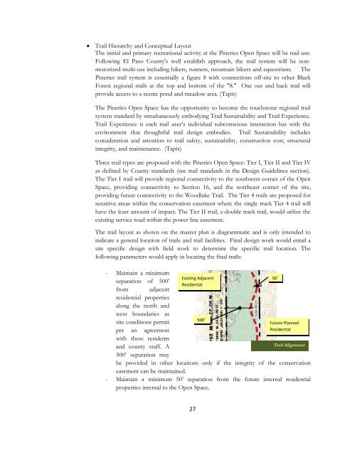
The trail layout as shown on the master plan is diagrammatic and is only intended to<br />
indicate a general location of trails and trail facilities. Final design work would entail a<br />
site specific design with field work to determine the specific trail location. The<br />
following parameters would apply in locating the final trails:<br />
- Maintain a minimum<br />
Existing Adjacent<br />
50’<br />
separation of 500’<br />
Residential<br />
from adjacent<br />
residential properties<br />
along the north and<br />
west boundaries as<br />
500’<br />
site conditions permit<br />
Future <strong>Plan</strong>ned<br />
per an agreement<br />
Residential<br />
with these residents<br />
and county staff. A<br />
Trail Alignment<br />
500’ separation may<br />
be provided in other locations only if the integrity of the conservation<br />
easement can be maintained.<br />
- Maintain a minimum 50’ separation from the future internal residential<br />
properties internal to the <strong>Open</strong> <strong>Space</strong>.<br />
27