Draft plan - Stuff
Draft plan - Stuff
Draft plan - Stuff

You also want an ePaper? Increase the reach of your titles
YUMPU automatically turns print PDFs into web optimized ePapers that Google loves.
Past Present and Future<br />
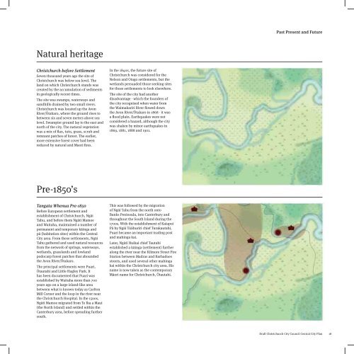
Natural heritage<br />
Christchurch before Settlement<br />
Seven thousand years ago the site of<br />
Christchurch was below sea level. The<br />
land on which Christchurch stands was<br />
created by the accumulation of sediments<br />
in geologically recent times.<br />
The site was swamps, waterways and<br />
sandhills drained by two small rivers.<br />
Christchurch was located up the Avon<br />
River/Ōtakaro, where the ground rises to<br />
between six and seven metres above sea<br />
level. Swampier ground lay to the east and<br />
north of the city. The natural vegetation<br />
was a mix of flax, tutu, grass, scrub and<br />
remnant patches of forest. The earlier,<br />
more extensive forest cover had been<br />
reduced by natural and Maori fires.<br />
In the 1840s, the future site of<br />
Christchurch was considered for the<br />
Nelson and Otago settlements, but the<br />
wetlands persuaded those seeking sites<br />
for those settlements to look elsewhere.<br />
The site of the city had another<br />
disadvantage - which the founders of<br />
the city recognised when water from<br />
the Waimakariri River flowed down<br />
the Avon River/Ōtakaro in 1868 - it was<br />
a flood plain. Earthquakes were not<br />
considered a hazard, although the city<br />
was shaken by minor earthquakes in<br />
1869, 1881, 1888 and 1901.<br />
Pre-1850’s<br />
Tangata Whenua Pre-1850<br />
Before European settlement and<br />
establishment of Christchurch, Ngāi<br />
Tahu, and before them Ngāti Mamoe<br />
and Waitaha, maintained a number of<br />
permanent and temporary kāinga and<br />
pā (habitation sites) within the Central<br />
City area. From these settlements, Ngāi<br />
Tahu gathered and used natural resources<br />
from the network of springs, waterways,<br />
wetlands, grasslands and lowland<br />
podocarp forest patches that abounded<br />
the Avon River/Ōtakaro.<br />
The principal settlements were Puari,<br />
Ōtautahi and Little Hagley Park. It<br />
has been documented that Puari was<br />
established by Waitaha more than 700<br />
years ago on a large island-like area<br />
between what is known today as Carlton<br />
Mill Corner and the loop in the river near<br />
the Christchurch Hospital. In the 1500s,<br />
Ngāti Mamoe migrated from Te Ika a Maui<br />
(the North Island) and settled within the<br />
Canterbury area, before spreading further<br />
south.<br />
This was followed by the migration<br />
of Ngāi Tahu from the north onto<br />
Banks Peninsula, into Canterbury and<br />
throughout the South Island during the<br />
1700s. With the establishment of Kaiapoi<br />
Pā by Ngāi Tūāhuriri chief Turakautahi,<br />
Puari became an important trading post<br />
and mahinga kai.<br />
Later, Ngāti Huikai chief Tautahi<br />
established a kāinga (settlement) further<br />
along the river near the Kilmore Street Fire<br />
Station between Madras and Barbadoes<br />
streets, and used several other mahinga<br />
kai within the Christchurch city area. His<br />
name is now taken as the contemporary<br />
Māori name for Christchurch, Ōtautahi.<br />
<strong>Draft</strong> Christchurch City Council Central City Plan<br />
18