Draft plan - Stuff
Draft plan - Stuff
Draft plan - Stuff

You also want an ePaper? Increase the reach of your titles
YUMPU automatically turns print PDFs into web optimized ePapers that Google loves.
Distinctive City<br />
Strengthening the grid<br />
The grid of the city is a strong feature of<br />
Christchurch and one that is made possible and<br />
accentuated by the flat landscape in which it sits.<br />
The grid is typical of colonial<br />
settlements as it was easy to<br />
survey and its rectangular sections<br />
facilitated land sales.<br />
The rigid grid is relieved by several<br />
features, including the Avon River/Ōtakaro,<br />
Cranmer and Latimer Squares and two<br />
diagonal streets cutting across the grid –<br />
one originally leading to Papanui Bush<br />
(Victoria Street), the other to Ferrymead<br />
near the base of the Bridle Path (High<br />
Street/Ferry Road).<br />
Despite some relief, the formality of the<br />
colonial grid creates enormous spaces,<br />
both between and within its 100m x 200m<br />
blocks.<br />
Three large squares provide generous<br />
public open spaces within the Central City,<br />
in addition to the vastness of Hagley Park.<br />
Christchurch’s wide streets permit distant<br />
views to the Port Hills and Southern Alps.<br />
While these qualities are important to the<br />
identity of Christchurch, and should not<br />
be compromised, there are opportunities<br />
to complement this with a fine-grained,<br />
plot-based approach to building design and<br />
the creation of different types of laneway<br />
and courtyard spaces within blocks. This<br />
ensures the scale of the city becomes more<br />
people-friendly and accommodates a<br />
diversity of activities and experiences.<br />
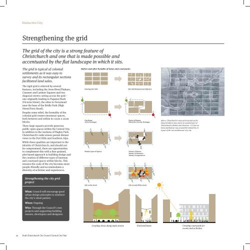
Before and after benefits of lanes and courtyards:<br />
Existing City Grid<br />
One Route<br />
Active frontages<br />
Similar types of Spaces<br />
City Grid Retained and Added to<br />
Choice of Routes<br />
Hierarchy of active frontages<br />
Variety of Spaces<br />
Variety of tenancies<br />
Variety of experiences<br />
Above: Christchurch’s street grid was laid out by<br />
Edward Jollie in 1850 and is an essential part of<br />
Christchurch’s identity and character - it’s how we<br />
know and find our way around the Central City. It<br />
is part of the ‘core architecture’ of a city.<br />
Strengthening the city grid<br />
project<br />
Life on the street<br />
Life on and off the street<br />
What: Council will encourage good<br />
urban design principles to reinforce<br />
the city’s street pattern<br />
When: Ongoing<br />
Who: Through the Council’s own<br />
projects and supporting building<br />
owners, developers and designers<br />
Creating views along main streets Enclosed lanes Creating courtyards for<br />
events and activities<br />
59<br />
<strong>Draft</strong> Christchurch City Council Central City Plan