Bathgate Watershed - Office of Physical Plant - Penn State University
Bathgate Watershed - Office of Physical Plant - Penn State University
Bathgate Watershed - Office of Physical Plant - Penn State University

Create successful ePaper yourself
Turn your PDF publications into a flip-book with our unique Google optimized e-Paper software.
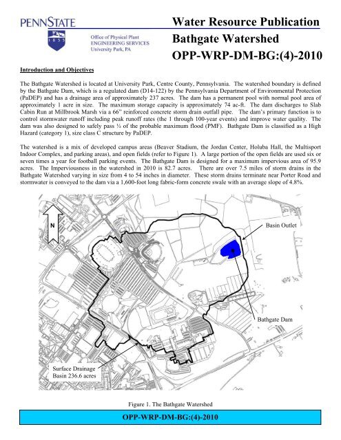
Introduction and Objectives<br />
Water Resource Publication<br />
<strong>Bathgate</strong> <strong>Watershed</strong><br />
OPP-WRP-DM-BG:(4)-2010<br />
The <strong>Bathgate</strong> <strong>Watershed</strong> is located at <strong>University</strong> Park, Centre County, <strong>Penn</strong>sylvania. The watershed boundary is defined<br />
by the <strong>Bathgate</strong> Dam, which is a regulated dam (D14-122) by the <strong>Penn</strong>sylvania Department <strong>of</strong> Environmental Protection<br />
(PaDEP) and has a drainage area <strong>of</strong> approximately 237 acres. The dam has a permanent pool with normal pool area <strong>of</strong><br />
approximately 1 acre in size. The maximum storage capacity is approximately 74 ac-ft. The dam discharges to Slab<br />
Cabin Run at Millbrook Marsh via a 66” reinforced concrete storm drain outfall pipe. The dam’s primary function is to<br />
control stormwater run<strong>of</strong>f including peak run<strong>of</strong>f rates (the 1 through 100-year events) and improve water quality. The<br />
dam was also designed to safely pass ½ <strong>of</strong> the probable maximum flood (PMF). <strong>Bathgate</strong> Dam is classified as a High<br />
Hazard (category 1), size class C structure by PaDEP.<br />
The watershed is a mix <strong>of</strong> developed campus areas (Beaver Stadium, the Jordan Center, Holuba Hall, the Multisport<br />
Indoor Complex, and parking areas), and open fields (refer to Figure 1). A large portion <strong>of</strong> the open fields are used six or<br />
seven times a year for football parking events. The <strong>Bathgate</strong> Dam is designed for a maximum impervious area <strong>of</strong> 95.9<br />
acres. The Imperviousness in the watershed in 2010 is 82.7 acres. There are over 7.5 miles <strong>of</strong> storm drains in the<br />
<strong>Bathgate</strong> <strong>Watershed</strong> varying in size from 4 to 54 inches in diameter. These storm drains terminate near Porter Road and<br />
stormwater is conveyed to the dam via a 1,600-foot long fabric-form concrete swale with an average slope <strong>of</strong> 4.8%.<br />
N<br />
Basin Outlet<br />
<strong>Bathgate</strong> Dam<br />
Surface Drainage<br />
Basin 236.6 acres<br />
Figure 1. The <strong>Bathgate</strong> <strong>Watershed</strong><br />
OPP-WRP-DM-BG:(4)-2010
<strong>Penn</strong> <strong>State</strong> <strong>University</strong><br />
Water Resource Publication<br />
Soils and Geology<br />
The majority <strong>of</strong> the <strong>Bathgate</strong> <strong>Watershed</strong> is identified as a Hagerstown Series by the Soil Survey <strong>of</strong> Centre County. The<br />
most significant limitation identified in the soil survey <strong>of</strong> Hagerstown soils is possible sinkhole formation and ground<br />
water pollution hazard if the soil is used for waste disposal. In addition to the Hagerstown soils, there are small amounts<br />
<strong>of</strong> Nolin, Opequon-Rock, Opequon-Hagerstown complex, and Urban-Hagerstown complex also located within the<br />
drainage basin. Although these soils are traditionally considered to be hydrologic soil group (HSG) C soils by the NRCS,<br />
an intensive analysis conducted for the Spring Creek Drainage Basin (ACT 167 Plan) has shown that the soils more<br />
reasonably respond as HSG B soils. The majority <strong>of</strong> the watershed is underlain by bedrock <strong>of</strong> the Nittany limestone (On)<br />
formation, which is described by dark-gray, finely to coarsely crystalline dolomite.<br />
Hydrologic Budget<br />
Since late 2006, the <strong>University</strong> has instituted a continuous discharge-monitoring program at the <strong>Bathgate</strong> Dam. Because<br />
the <strong>Bathgate</strong> watershed is mostly developed with directly connected impervious areas, the watershed outflows are highly<br />
influenced by the imperviousness. Peak discharges from the watershed are well controlled, but run<strong>of</strong>f volume is not<br />
reduced due to the absence <strong>of</strong> recharge areas given the watershed’s topography and underlying geology.<br />
The dam has a normal pool elevation <strong>of</strong> 993.25; however, there are three small holes (bleed outs) with inverts at elevation<br />
992.50 that slowly draw down the pool elevation. Because <strong>of</strong> these small holes, the dam usually discharges low flows<br />
year round with the exception <strong>of</strong> dry periods in the late summer or fall. This slow release can be seen in Figure 2. There<br />
is approximately 1 ac-ft <strong>of</strong> storage capacity between the normal pool elevation and the three small holes.<br />
995.0<br />
994.5<br />
994.0<br />
Elevation (ft)<br />
993.5<br />
993.0<br />
992.5<br />
992.0<br />
9/1 9/16 10/1 10/16 10/31<br />
Date<br />
Figure 2. Dam Water Surface Elevation Over Time<br />
The control structure at elevation 993.25 is a 4.25-foot wide broad crested weir, for which discharges can be reasonably<br />
computed. The small bleed out holes are prone to minor clogging and while the peak run<strong>of</strong>f rates are not significantly<br />
affected by this clogging, the computed run<strong>of</strong>f volumes can be.<br />
OPP-WRP-DM-BG:(4)-2010
<strong>Penn</strong> <strong>State</strong> <strong>University</strong><br />
Water Resource Publication<br />
During 2010, 37.7 inches <strong>of</strong> precipitation fell in the watershed resulting in the pond discharging approximately 185 ac-ft<br />
<strong>of</strong> run<strong>of</strong>f, which is equivalent to a discharge to precipitation ratio <strong>of</strong> 0.20, which is the lowest percentage since data<br />
collection started. Almost all larger precipitation events produced run<strong>of</strong>f. The graph <strong>of</strong> discharges from the dam for the<br />
year can be seen in Figure 3.<br />
Significant Run<strong>of</strong>f Events <strong>of</strong> 2010<br />
Figure 3. Discharge from the <strong>Bathgate</strong> Dam for 2010<br />
The 2010 year produced seven run<strong>of</strong>f events greater than 10 cfs and there were eight precipitation events greater than 1.0”<br />
in total depth. The eight most significant run<strong>of</strong>f/rainfall events <strong>of</strong> the year are shown in the table below.<br />
Basin Basin Q/P Q/P 5 Day<br />
Outlet Outlet Ratio Ratio Max 5min Max 1hr Antecedent<br />
Day Event P (in) Qp (cfs) Q (ac-ft) 237 ac 82 ac P (in) P (in) P (in)<br />
1/25/10 1.90 19.3 11.0 0.29 0.85 0.08 0.52 0.09<br />
3/14/10 1.83 8.5 10.7 0.30 0.86 0.04 0.19 0.30<br />
5/12/10 1.15 11.2 7.5 0.33 0.95 0.09 0.46 0.43<br />
6/10/10 1.14 9.4 7.1 0.32 0.91 0.06 0.32 0.19<br />
7/10/10 2.12 22.0 11.4 0.27 0.79 0.19 1.21 0.00<br />
8/22/10 1.49 14.6 7.7 0.26 0.76 0.10 0.58 0.00<br />
10/1/10 3.66 28.1 19.5 0.27 0.78 0.12 0.79 1.04<br />
11/30/10 3.07 20.2 20.3 0.33 0.97 na na 1.05<br />
The event <strong>of</strong> October 1 st generated the highest peak run<strong>of</strong>f rate <strong>of</strong> the year, which was approximately 28.1cfs. The Walker<br />
Building Weather Station recorded 3.66” <strong>of</strong> rainfall over an 18 hour period. The run<strong>of</strong>f hydrograph for the October 1 st<br />
event can be seen in Figure 4. During early September, the dam’s water surface elevation was below the bleed out<br />
elevations as can be seen in Figure 5.<br />
OPP-WRP-DM-BG:(4)-2010
<strong>Penn</strong> <strong>State</strong> <strong>University</strong><br />
Water Resource Publication<br />
Figure 4. Run<strong>of</strong>f Event <strong>of</strong> October 1, 2010<br />
Water Quality and Thermal Issues<br />
The <strong>Bathgate</strong> dam is a water quality and peak run<strong>of</strong>f rate control facility. No water quality sampling <strong>of</strong> surface water was<br />
been conducted in 2010.<br />
Because the dam acts as a retention pond with a permanent pool, thermal impacts occur due to the solar heating <strong>of</strong> the<br />
water. Temperatures are recorded 1 foot below the normal pool elevation. Diurnal temperature fluctuations occur and<br />
temperatures also go through an expected annual cycle with run<strong>of</strong>f event fluctuations.<br />
Miscellaneous Information<br />
Drainage Basins: Slab Cabin Run/Spring Creek/Bald Eagle Creek/West Branch Susquehanna River<br />
PA Title 25, Chapter 93 Water Quality Classification: Cold Water Fishery (CWF)<br />
USGS Quadrangle: <strong>State</strong> College<br />
Hydrologic Unit Code: 02050204<br />
<strong>Watershed</strong> Outlet Latitude/Longitude: 40° 48’ 46” / 77° 50’ 37”<br />
Basin Municipalities: <strong>State</strong> College Borough, College Township<br />
NPDES Permit for Basin: PAS10F106(3)<br />
Municipal Separate Storm Sewer System (MS4) Permit: PAI-134807<br />
Basin Stormwater Management Plan: Spring Creek Act 167, Adopted August 6, 2002<br />
<strong>Bathgate</strong> Dam Permit: D14-122<br />
OPP-WRP-DM-BG:(4)-2010
<strong>Penn</strong> <strong>State</strong> <strong>University</strong><br />
Water Resource Publication<br />
References and Additional Information on the Basin<br />
Berkey, L.A., L.E. Storm, C.R. Whitson, and A.T. Bain. 2003. Engineering, Permitting and Environmental Issues Related<br />
to the Renovation <strong>of</strong> a Stormwater Management System at the <strong>Penn</strong>sylvania <strong>State</strong> <strong>University</strong>, <strong>University</strong> Park<br />
Campus. Proceedings <strong>of</strong> the <strong>Penn</strong>sylvania Stormwater Management Symposium, Implementing Stormwater<br />
Management, Integration <strong>of</strong> Planning, Regulation, Design, and Operations. Villanova <strong>University</strong>, PA.<br />
Gannett Fleming. 1999. <strong>Bathgate</strong> Detention Pond Expansion and Storm Sewer Outfall System. Engineering Study. PSU<br />
Project No. 01-70653. Unpublished Technical Report for <strong>Penn</strong> <strong>State</strong> <strong>University</strong>. March 1999.<br />
L. Robert Kimball. 1991. Storm water Management Report for the <strong>Penn</strong>sylvania <strong>State</strong> <strong>University</strong> Construction <strong>of</strong><br />
Commuter Parking Lots (original <strong>Bathgate</strong> Dam Design Report). Unpublished Technical Report for <strong>Penn</strong> <strong>State</strong><br />
<strong>University</strong>. Revised February 1991.<br />
Figure 5. Dam on September 9 th , 2010 when Water Surface Elevation was Lowest <strong>of</strong> the Year<br />
Publisher: <strong>Penn</strong> <strong>State</strong> <strong>University</strong>, <strong>Office</strong> <strong>of</strong> <strong>Physical</strong> <strong>Plant</strong>, Energy and Engineering Division, Engineering Services<br />
Editor: Larry Fennessey, OPP Stormwater Engineer, Ph: (814) 863-8743, email: laf8@psu.edu<br />
OPP-WRP-DM-BG:(4)-2010