M-5 Marine Highway Corridor - Maritime Administration - U.S. ...
M-5 Marine Highway Corridor - Maritime Administration - U.S. ...
M-5 Marine Highway Corridor - Maritime Administration - U.S. ...

Create successful ePaper yourself
Turn your PDF publications into a flip-book with our unique Google optimized e-Paper software.
M-10 <strong>Marine</strong> <strong>Highway</strong> <strong>Corridor</strong><br />
Sponsor: Mississippi Department of Transportation<br />
Supporters: Florida DOT, Texas DOT, Louisiana DOT, NW Louisiana Economic<br />
Development Foundation, South Alabama Regional Planning Commission, Port of<br />
Jacksonville, Port of Tampa, Port of Pensacola, Port of Pascagoula, Port of Morgan<br />
City, Port of New Orleans, St. Bernard Terminal and Harbor District, Port of Lake<br />
Charles, Port of Houston Authority, Port of Brownsville, and Gulf Intracoastal Canal<br />
Association.<br />
Landside <strong>Corridor</strong> Served: Interstate-10<br />
<strong>Corridor</strong> Description:<br />
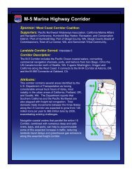
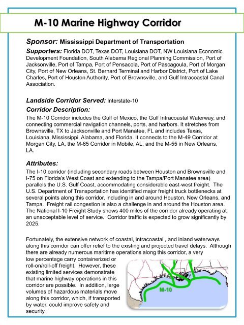
The M-10 <strong>Corridor</strong> includes the Gulf of Mexico, the Gulf Intracoastal Waterway, and<br />
connecting commercial navigation channels, ports, and harbors. It stretches from<br />
Brownsville, TX to Jacksonville and Port Manatee, FL and includes Texas,<br />
Louisiana, Mississippi, Alabama, and Florida. It connects to the M-49 <strong>Corridor</strong> at<br />
Morgan City, LA, the M-65 <strong>Corridor</strong> in Mobile, AL, and the M-55 in New Orleans,<br />
LA.<br />
Attributes:<br />
The I-10 corridor (including secondary roads between Houston and Brownsville and<br />
I-75 on Florida’s West Coast and extending to the Tampa/Port Manatee area)<br />
parallels the U.S. Gulf Coast, accommodating considerable east-west freight. The<br />
U.S. Department of Transportation has identified major freight truck bottlenecks at<br />
several points along this corridor, including in and around Houston, New Orleans, and<br />
Tampa. Freight rail congestion is also a challenge in and around the Houston area.<br />
The National I-10 Freight Study shows 400 miles of the corridor already operating at<br />
an unacceptable level of service. <strong>Corridor</strong> traffic is expected to grow significantly by<br />
2025.<br />
Fortunately, the extensive network of coastal, intracoastal , and inland waterways<br />
along this corridor can offer relief to the existing and projected travel delays. Although<br />
there are already numerous maritime operations along this corridor, a very<br />
low percentage carry containerized or<br />
roll-on/roll-off freight. However, these<br />
existing limited services demonstrate<br />
that marine highway operations in this<br />
corridor are possible. In addition, large<br />
volumes of hazardous materials move<br />
along this corridor, which, if transported<br />
by water, could improve safety and<br />
security.