M-5 Marine Highway Corridor - Maritime Administration - U.S. ...
M-5 Marine Highway Corridor - Maritime Administration - U.S. ...
M-5 Marine Highway Corridor - Maritime Administration - U.S. ...

You also want an ePaper? Increase the reach of your titles
YUMPU automatically turns print PDFs into web optimized ePapers that Google loves.
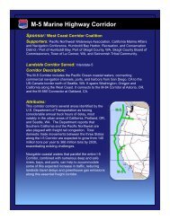
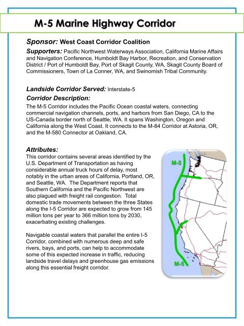
M-5 <strong>Marine</strong> <strong>Highway</strong> <strong>Corridor</strong><br />
Sponsor: West Coast <strong>Corridor</strong> Coalition<br />
Supporters: Pacific Northwest Waterways Association, California <strong>Marine</strong> Affairs<br />
and Navigation Conference, Humboldt Bay Harbor, Recreation, and Conservation<br />
District / Port of Humboldt Bay, Port of Skagit County, WA, Skagit County Board of<br />
Commissioners, Town of La Conner, WA, and Swinomish Tribal Community.<br />
Landside <strong>Corridor</strong> Served: Interstate-5<br />
<strong>Corridor</strong> Description:<br />
The M-5 <strong>Corridor</strong> includes the Pacific Ocean coastal waters, connecting<br />
commercial navigation channels, ports, and harbors from San Diego, CA to the<br />
US-Canada border north of Seattle, WA. It spans Washington, Oregon and<br />
California along the West Coast. It connects to the M-84 <strong>Corridor</strong> at Astoria, OR,<br />
and the M-580 Connector at Oakland, CA.<br />
Attributes:<br />
This corridor contains several areas identified by the<br />
U.S. Department of Transportation as having<br />
considerable annual truck hours of delay, most<br />
notably in the urban areas of California, Portland, OR,<br />
and Seattle, WA. The Department reports that<br />
Southern California and the Pacific Northwest are<br />
also plagued with freight rail congestion. Total<br />
domestic trade movements between the three States<br />
along the I-5 <strong>Corridor</strong> are expected to grow from 145<br />
million tons per year to 366 million tons by 2030,<br />
exacerbating existing challenges.<br />
Navigable coastal waters that parallel the entire I-5<br />
<strong>Corridor</strong>, combined with numerous deep and safe<br />
rivers, bays, and ports, can help to accommodate<br />
some of this expected increase in traffic, reducing<br />
landside travel delays and greenhouse gas emissions<br />
along this essential freight corridor.
M-580 <strong>Marine</strong> <strong>Highway</strong> <strong>Corridor</strong><br />
Sponsor: Port of Stockton, California<br />
Supporters: Bay Area Air Quality Management District, San Joaquin Valley Air<br />
Pollution Control District, Port of Oakland, and the Port of West Sacramento.<br />
Landside <strong>Corridor</strong> Served: Interstate-580<br />
<strong>Corridor</strong> Description:<br />
The M-580 <strong>Corridor</strong> includes the San Joaquin River, Sacramento River, and<br />
connecting commercial navigation channels, ports, and harbors in Central<br />
California from Sacramento, CA to Oakland. It connects to the M-5 <strong>Corridor</strong> at<br />
Oakland.<br />
Attributes:<br />
I-580 is one of the most congested highways in the nation, and has been identified<br />
by the U.S. Department of Transportation as having significant annual truck hours<br />
of delay. Approximately 25 percent of the Port of Oakland’s volume travels to and<br />
from the San Joaquin Valley of California, an area already recognized for some of<br />
the country’s worst air pollution. By 2020, the Port of Oakland’s volume is<br />
expected to increase by 65 percent, further exacerbating the Valley’s congestion<br />
and air quality issues.<br />
An increased movement of freight by water<br />
could help to relieve this situation. In 2007,<br />
nearly 3.4 million tons of waterborne cargo,<br />
mainly bulk goods, moved through the Port<br />
of Stockton via the Stockton Deepwater<br />
Ship Channel and San Joaquin River,<br />
underscoring the potential capacity of this<br />
waterway system. One example of the<br />
potential for waterborne freight movements<br />
along this corridor is a proposed marine<br />
highway service between the Ports of<br />
Oakland, Stockton, and West Sacramento.<br />
Fully implemented, it could eliminate<br />
180,000 truck trips from I-580, I-80, and<br />
I-205 annually, saving approximately<br />
7 million gallons of fuel and reducing air<br />
emissions in the process.
M-84 <strong>Marine</strong> <strong>Highway</strong> <strong>Corridor</strong><br />
Sponsor: Port of Portland, Oregon<br />
Supporter: The Pacific Northwest Waterways Association.<br />
Landside <strong>Corridor</strong> Served: Interstate-84<br />
<strong>Corridor</strong> Description:<br />
The M-84 <strong>Corridor</strong> includes the Columbia and Snake Rivers, connecting<br />
commercial navigation channels, ports, and harbors. It spans Oregon and Idaho<br />
from Astoria, OR to Lewiston, ID. It connects to the M-5 <strong>Corridor</strong> in Astoria, OR.<br />
Attributes:<br />
I-84, which parallels the Columbia River in Oregon, has been identified as a freight<br />
truck bottleneck by the U.S. Department of Transportation, resulting in up to<br />
750,000 truck hours of delay annually. This is also noted by the Department as an<br />
area of major rail congestion. Containers from the Ports of Seattle, Tacoma, and<br />
Portland currently move by truck on I-84 (and I-5), and 55 percent of the region's<br />
container market moves through Puget Sound, causing additional truck and rail<br />
freight traffic between these ports.<br />
Increasing the use of the water route paralleling I-84 can help mitigate landside<br />
congestion, reduce air emissions, and conserve energy. A container-on-barge<br />
service currently calling on smaller ports along the Columbia and Snake Rivers is<br />
one example of the corridor’s potential. A proposed weekly service between the<br />
Ports of Umatilla, Portland, Seattle, and Tacoma could also accommodate the<br />
equivalent of 36,000 trucks that travel the I-5 landside corridor each year. An<br />
operation like this could serve both agricultural exporters and importers in the<br />
Pacific Northwest shipping to Far East markets.
M-10 <strong>Marine</strong> <strong>Highway</strong> <strong>Corridor</strong><br />
Sponsor: Mississippi Department of Transportation<br />
Supporters: Florida DOT, Texas DOT, Louisiana DOT, NW Louisiana Economic<br />
Development Foundation, South Alabama Regional Planning Commission, Port of<br />
Jacksonville, Port of Tampa, Port of Pensacola, Port of Pascagoula, Port of Morgan<br />
City, Port of New Orleans, St. Bernard Terminal and Harbor District, Port of Lake<br />
Charles, Port of Houston Authority, Port of Brownsville, and Gulf Intracoastal Canal<br />
Association.<br />
Landside <strong>Corridor</strong> Served: Interstate-10<br />
<strong>Corridor</strong> Description:<br />
The M-10 <strong>Corridor</strong> includes the Gulf of Mexico, the Gulf Intracoastal Waterway, and<br />
connecting commercial navigation channels, ports, and harbors. It stretches from<br />
Brownsville, TX to Jacksonville and Port Manatee, FL and includes Texas,<br />
Louisiana, Mississippi, Alabama, and Florida. It connects to the M-49 <strong>Corridor</strong> at<br />
Morgan City, LA, the M-65 <strong>Corridor</strong> in Mobile, AL, and the M-55 in New Orleans,<br />
LA.<br />
Attributes:<br />
The I-10 corridor (including secondary roads between Houston and Brownsville and<br />
I-75 on Florida’s West Coast and extending to the Tampa/Port Manatee area)<br />
parallels the U.S. Gulf Coast, accommodating considerable east-west freight. The<br />
U.S. Department of Transportation has identified major freight truck bottlenecks at<br />
several points along this corridor, including in and around Houston, New Orleans, and<br />
Tampa. Freight rail congestion is also a challenge in and around the Houston area.<br />
The National I-10 Freight Study shows 400 miles of the corridor already operating at<br />
an unacceptable level of service. <strong>Corridor</strong> traffic is expected to grow significantly by<br />
2025.<br />
Fortunately, the extensive network of coastal, intracoastal , and inland waterways<br />
along this corridor can offer relief to the existing and projected travel delays. Although<br />
there are already numerous maritime operations along this corridor, a very<br />
low percentage carry containerized or<br />
roll-on/roll-off freight. However, these<br />
existing limited services demonstrate<br />
that marine highway operations in this<br />
corridor are possible. In addition, large<br />
volumes of hazardous materials move<br />
along this corridor, which, if transported<br />
by water, could improve safety and<br />
security.
M-49 <strong>Marine</strong> <strong>Highway</strong> <strong>Corridor</strong><br />
Sponsor: Louisiana Department of Transportation &<br />
Development<br />
Supporters: NE Louisiana Economic Development Foundation, Rapides Area<br />
Planning Commission, The Port of Morgan City, Natchitoches Parish, Port of<br />
New Orleans, Port of Greater Baton Rouge, Port of Krotz Springs, and the<br />
Caddo/Bossier Port Commission.<br />
Landside <strong>Corridor</strong> Served: Interstate-49<br />
<strong>Corridor</strong> Description:<br />
The M-49 <strong>Corridor</strong> includes the Atchafalaya River, the J. Bennett Johnson<br />
Waterway, and connecting commercial navigation channels, ports, and harbors. It<br />
spans southwest Louisiana from Morgan City, LA to Shreveport along US<br />
<strong>Highway</strong> 90 and Interstate 49. It connects to the M-10 <strong>Corridor</strong> at Morgan City.<br />
Attributes:<br />
This corridor serves four South Louisiana ports, including Port Fourchon, Port of<br />
West St. Mary, Morgan City, and the Terrebonne Port Commission (Houma),<br />
transporting significant volumes of freight along the landside route. During the<br />
six years from 2000 to 2006, the corridor experienced a 19 percent increase in<br />
vehicle traffic, of which approximately 20 percent was truck traffic, clearly<br />
indicating an upward trend in freight and congestion.<br />
The J. Bennett Johnston Waterway<br />
(formerly known as the Red River<br />
Waterway) moved 9.1 million short<br />
tons (7.5 billion ton-miles) of freight in<br />
2007, demonstrating the corridor’s<br />
potential capacity for waterborne<br />
goods movement. However, neither<br />
the J. Bennett Johnston Waterway nor<br />
Bayou Teche currently have container<br />
or trailer marine services. A more<br />
efficient freight distribution system<br />
could have significant benefits to the<br />
region.
M-55 <strong>Marine</strong> <strong>Highway</strong> <strong>Corridor</strong><br />
Sponsor: Missouri Department of Transportation<br />
Supporters: Southeast Missouri Regional Port Authority, and the Ohio<br />
Department of Transportation.<br />
Landside <strong>Corridor</strong> Served: Interstate-55<br />
<strong>Corridor</strong> Description:<br />
The M-55 <strong>Corridor</strong> includes the Mississippi and Illinois Rivers from New Orleans,<br />
LA, via St. Louis, MO, to Chicago, IL, through Louisiana, Mississippi, Arkansas,<br />
Tennessee, Missouri, and Illinois. It includes connecting commercial navigation<br />
channels, ports, and harbors. It connects to the M-90 corridor at Chicago, the M-40<br />
Connector at Napoleon, AR, crosses the M-70 <strong>Corridor</strong> at St. Louis, MO, and<br />
meets the M-10 <strong>Corridor</strong> at New Orleans, LA.<br />
Attributes:<br />
At 2,348 miles in length, the Mississippi River is the 2nd<br />
longest river in the United States and 92 percent of the<br />
nation’s agricultural exports are produced in its basin. Sixty<br />
percent of all U.S. grain exports move on the Mississippi<br />
River and the largest port in the United States (by tonnage)<br />
is located on the Mississippi at LaPlace, LA. The Port of<br />
New Orleans handled 229,067 containers (TEUs) in 2008,<br />
most of which also move inland on truck and rail.<br />
The U.S. Department of Transportation indicates that this<br />
corridor is plagued with major freight truck bottlenecks at<br />
several points along its route, including the metropolitan<br />
areas of Chicago, St. Louis, Baton Rouge, and New Orleans,<br />
causing millions of hours in truck delay each year. In<br />
addition, the Department found that freight rail congestion is<br />
problematic for both in the Chicago and St. Louis areas.<br />
Even in rural segments, traffic studies on portions of I-55 in<br />
Southeast Missouri found that trucks account for<br />
approximately 50 percent of all daily vehicle movements.<br />
The increased use of the <strong>Marine</strong> <strong>Highway</strong> component of the<br />
corridor in this area has the potential to reduce air<br />
emissions, conserve energy, lower highway maintenance<br />
costs, and enhance safety, although key infrastructure,<br />
including locks and dams, require modernization.
M-65 <strong>Marine</strong> <strong>Highway</strong> <strong>Corridor</strong><br />
Sponsor: Tennessee-Tombigbee Waterway Development<br />
Authority<br />
Supporters: State of Alabama, Alabama State Port Authority, West Virginia DOT,<br />
South Alabama Regional Planning Commission, Yellow Creek State Inland Port<br />
Authority, Paducah-McCracken County Riverport Authority, Port Itawamba,<br />
Lowndes County Port Authority, Coalition of Alabama Waterway Associations, Inc.<br />
Landside <strong>Corridor</strong> Served: Interstate-65<br />
<strong>Corridor</strong> Description:<br />
The M-65 <strong>Corridor</strong> includes the Mobile, Tombigbee, and Black Warrior Rivers from<br />
the Port of Mobile to the Port of Birmingham; and the Mobile River, Tennessee-<br />
Tombigbee Waterway, and Tennessee River via the Ohio River in Paducah, KY, to<br />
the Mississippi River. The corridor also includes all commercial navigation<br />
channels, ports, and harbors in Alabama, Mississippi, and Tennessee. It connects<br />
to the M-10 <strong>Corridor</strong> in Mobile and the M-55 <strong>Corridor</strong> in Cairo, Illinois.<br />
Attributes:<br />
According to the South Alabama Regional<br />
Planning Commission, over 3,150 freight trucks<br />
move northward from Southern Alabama along<br />
the I-65 <strong>Corridor</strong> on a daily basis. Of this number,<br />
an estimated 500 of these trucks transport<br />
hazardous materials north from the Mobile area.<br />
The U.S. Department of Transportation forecasts<br />
that daily traffic on the overall corridor could grow<br />
to 25,000 long haul trucks by 2035.<br />
This <strong>Marine</strong> <strong>Highway</strong> corridor could help mitigate<br />
some of these anticipated increases in freight and<br />
hazardous materials movements through<br />
increased utilization of the Tennessee-Tombigbee<br />
Waterway. Both the planned expansion of the<br />
Port of Mobile and the chemical production<br />
facilities of southern Alabama could benefit from<br />
expansion of maritime capacity along this corridor.
M-70 <strong>Marine</strong> <strong>Highway</strong> <strong>Corridor</strong><br />
Sponsor: Ohio Department of Transportation<br />
Supporters: Illinois DOT, Missouri Chamber of Commerce, Missouri DOT, and<br />
Cape Girardeau Area MAGNET.<br />
Landside <strong>Corridor</strong> Served: Interstate-70<br />
<strong>Corridor</strong> Description:<br />
The M-70 <strong>Corridor</strong> includes the Ohio, Mississippi, and Missouri Rivers, and<br />
connecting commercial navigation channels, ports, and harbors, from Pittsburgh to<br />
Kansas City. It spans Pennsylvania, Ohio, Indiana, Illinois, and Missouri,<br />
connecting to the M-55 <strong>Corridor</strong> at St. Louis, MO.<br />
Attributes:<br />
This corridor contains major freight truck bottlenecks at numerous points, including<br />
Kansas City, St. Louis, Louisville, Dayton, Cincinnati, Columbus, and Pittsburgh.<br />
According to the U.S. Department of Transportation, long haul truck volumes are<br />
expected to reach 25,000 per day along major segments by 2035. Similarly, rail<br />
congestion is evident in and around Kansas City, St Louis, and several points<br />
along the corridor in Ohio.<br />
This <strong>Marine</strong> <strong>Highway</strong> corridor has the potential to help alleviate a portion of the<br />
congestion from the existing landside routes, while at the same time reducing<br />
emissions, conserving energy, improving safety ,and reducing highway<br />
maintenance costs. It can also contribute to increased economic and commercial<br />
activity in the region by removing barriers to efficient freight transportation.
M-90 <strong>Marine</strong> <strong>Highway</strong> <strong>Corridor</strong><br />
Sponsor: Ohio Department of Transportation<br />
Supporters: Wisconsin DOT, Greater Buffalo-Niagara Regional Transportation<br />
Council, Monroe County Planning & Dev. Dept., Algoma, WI, Port of Milwaukee,<br />
Cleveland-Cuyahoga County Port Authority, Lake Carriers Association, New York<br />
State DOT, and the New York State Canal Corporation.<br />
Landside <strong>Corridor</strong>s Served: Interstate-90 (Also Interstates-80 and 94)<br />
<strong>Corridor</strong> Description:<br />
The M-90 <strong>Corridor</strong> is the Great Lakes, Erie Canal, and connecting commercial<br />
navigation channels, ports, and harbors from Albany, NY to Chicago, IL and Duluth,<br />
MN. It spans New York, Pennsylvania, Ohio, Indiana, Illinois, Michigan ,and<br />
Wisconsin. It connects to the M-75 Detroit/Windsor Crossing near Detroit, MI, and<br />
the M-71/77 Lake Erie Crossing near Cleveland, OH.<br />
Attributes:<br />
I-90 is already experiencing major freight truck bottlenecks at several points and is<br />
expected to rank seventh in the nation for freight truck vehicle miles traveled by<br />
2020. Similarly, I-80 also suffers major freight truck bottlenecks and is Ohio’s top<br />
freight truck corridor based on vehicle miles traveled. It will represent<br />
approximately 20 percent of the State’s daily truck traffic by 2020.<br />
The corresponding <strong>Marine</strong> <strong>Highway</strong> <strong>Corridor</strong> provides benefits to both I-90 and<br />
I-80 and offers virtually unlimited capacity between from Western Lake Superior to<br />
the East Coast via the Saint Lawrence Seaway. Numerous vessel services<br />
currently utilize this corridor, but their container and trailer volumes are at present<br />
limited. New and expanded waterborne services offer the opportunity to absorb<br />
some of the future traffic congestion forecast for the corresponding landside<br />
corridor. In addition, while currently handling limited volumes of freight, the Erie<br />
Canal could provide a link between the Great Lakes and East Coast via the M-87<br />
Connector between Buffalo and Albany, NY.
M-95 <strong>Marine</strong> <strong>Highway</strong> <strong>Corridor</strong><br />
Sponsor: Interstate-95 <strong>Corridor</strong> Coalition<br />
Supporters: Council of State Governments' Eastern Regional Conference,<br />
Commonwealth of PA, NJDOT, CT DOT, CT <strong>Maritime</strong> Commission, Florida DOT, East<br />
Central FL RPC, Space Coast Transportation Planning Authority, Economic Development<br />
Commission of Florida's Space Coast, DE Valley RPC, DE River & Bay Authority, SE<br />
Regional Planning & Economic Dev Commission, Richmond Regional RPC, NJ<br />
Transportation Planning Authority, NY Metropolitan Transportation Council, NYCDOT,<br />
NYSDOT, Port of Baltimore, NC Ports, Port of Mass., Port of New Bedford, MA, City of<br />
New London, CT, Philadelphia Regional Port Authority, MD Port Commission, Philadelphia<br />
Regional Port Authority, ME Port Authority, Port Authority of NY & NJ, Port Canaveral, FL,<br />
SC State Port Authority, VA Port Authority, Port of Davisville, RI, Jaxport, FL, and the<br />
<strong>Maritime</strong> Association of the Port of New York & New Jersey.<br />
Landside <strong>Corridor</strong> Served: Interstate-95<br />
<strong>Corridor</strong> Description:<br />
The M-95 <strong>Corridor</strong> includes the Atlantic Ocean coastal waters,<br />
Atlantic Intracoastal Waterway, and connecting commercial<br />
navigation channels, ports, and harbors. It stretches from<br />
Miami, FL to Portland, ME and spans 15 states. It connects to<br />
the M-87 Connector and the M-90 <strong>Corridor</strong> near New York City;<br />
and the M-64 Connector at Norfolk, VA.<br />
Attributes:<br />
The 1,925 mile-long I-95 <strong>Corridor</strong> is the major North-South<br />
landside freight corridor on the East Coast. The U.S.<br />
Department of Transportation identified more than a dozen<br />
major freight truck bottlenecks along this route, along with<br />
significant critical rail congestion along the upper portions.<br />
Projections of future freight volumes indicate increasing freight<br />
congestion challenges, with limited opportunity to increase<br />
landside capacity.<br />
The <strong>Corridor</strong> is home to 15 of the largest 50 marine ports in the United States (as<br />
ranked by total throughput). These ports handle approximately 582 million short tons<br />
of cargo, or 26 percent of the national total. Much of this freight begins or ends its<br />
journey with an I-95 transit. Fortunately, the East Coast also possesses a host of<br />
waterways, bays, rivers, and the Atlantic coast itself. The <strong>Corridor</strong> is also lined with<br />
less congested, smaller niche ports that could play a vital part in the developing marine<br />
highway service network. While several <strong>Marine</strong> <strong>Highway</strong> operations already serve this<br />
corridor, there is significant opportunity for expansion to help address growing<br />
congestion, reduce greenhouse gas emissions, conserve energy, and lower landside<br />
infrastructure maintenance costs.
M-2 <strong>Marine</strong> <strong>Highway</strong> <strong>Corridor</strong><br />
Sponsor: San Juan Port Commission<br />
Supporters: The Ports of Ponce and marine/port facilities in Mayaguez, Ceiba<br />
(former US Naval Station Roosevelt Roads), Yabucoa, Guanica, Guayama,<br />
Guayanill, and Arebico.<br />
Landside <strong>Corridor</strong> Served: Interstate/Route-2<br />
<strong>Corridor</strong> Description:<br />
The M-2 <strong>Corridor</strong> includes the Caribbean Sea, and connecting commercial<br />
navigation channels, ports, and harbors around the perimeter of Puerto Rico via<br />
San Juan, Mayagüez, and Ponce.<br />
Attributes:<br />
Puerto Rico is served by just 250 miles of interstate highway and 169 miles of noninterstate<br />
facilities. By 2020 this system is expected to handle approximately 492<br />
million vehicle-miles of travel. According to the Federal <strong>Highway</strong> <strong>Administration</strong>,<br />
almost $1.4 billion will be required over the next 20 years to address congestionsourced<br />
problems. Adding to this is the fact that 90 percent of Puerto Rico’s cargo<br />
arrives by water (approximately 14 million tons), and 18 percent of its traffic is<br />
attributable to trucks originating from the Port of San Juan alone. There is no rail<br />
system to supplement goods movement by truck; as such, water represents the<br />
only potential alternative.<br />
This marine highway corridor which circles<br />
the island and connects the vital sea ports<br />
such as Ponce (Port of Las Americas),<br />
Mayaguez, Ceiba, Yabucoa, Guanica,<br />
Guayama, Guayanilla, and Arecibo offers<br />
the potential to provide relief for the<br />
movement of people and freight, especially<br />
into and out of the island’s sea ports.
M-40 <strong>Marine</strong> <strong>Highway</strong> Connector<br />
Sponsor: Arkansas Waterways Commission<br />
Supporters: Oklahoma DOT Waterways Advisory Board, Arkansas Waterways<br />
Commission, Tulsa Port of Catoosa, Muskogee City-County Port Authority, The<br />
Alliance - Economic Development of Jefferson County, Arkansas , including Pine<br />
Bluff-Jefferson County Port Authority, and Arkansas River Reg'l Intermodal<br />
Facilities Authority, Port of Fort Smith, and Little Rock Port Authority.<br />
Landside <strong>Corridor</strong> Served: Interstate-40<br />
<strong>Corridor</strong> Description:<br />
The M-40 Connector includes the McClellan Kerr Arkansas River Navigation<br />
System including the Arkansas, Verdigris and White Rivers. It stretches from the<br />
Port of Catoosa, OK, to the Mississippi River near Napoleon, AR, through<br />
Oklahoma and Arkansas. It includes connecting commercial navigation channels,<br />
ports, and harbors. It connects to the M-55 <strong>Corridor</strong> at Napoleon, AR.<br />
Attributes:<br />
The McClellan-Kerr Arkansas River offers a waterborne alternative to I-40 and<br />
other landside routes, traversing 445 miles from Tulsa, OK to its confluence with<br />
the Mississippi River (M-55), approximately 600 river miles upstream from New<br />
Orleans.<br />
The Ports of Little Rock (a major multimodal<br />
facility) and Catoosa, OK (near<br />
Tulsa, OK) are served by this<br />
connector. This marine highway already<br />
processes 12 million tons of freight<br />
annually. Both of these port facilities<br />
have the capacity to expand into<br />
intermodal container and trailer<br />
cargoes. As such, expanded utilization<br />
of this connector to the M-55 corridor<br />
offers considerable potential to reduce<br />
vehicle miles traveled in this region.
M-87 <strong>Marine</strong> <strong>Highway</strong> Connector<br />
Sponsor: New York State Department of Transportation<br />
Supporters: Albany Port District Commission, Port Authority of New York & New<br />
Jersey, and New York State Canal Corp.<br />
Landside <strong>Corridor</strong> Served: Interstate-87<br />
<strong>Corridor</strong> Description:<br />
The M-87 Connector is the Hudson River, connecting commercial navigation<br />
channels such as the Erie Canal, ports, and harbors from New York City to Albany,<br />
NY. It spans eastern New York State. It connects to the M-90 <strong>Corridor</strong> at Albany,<br />
NY, and the M-95 <strong>Corridor</strong> at New York City.<br />
Attributes:<br />
Transiting through two areas that experience major freight truck bottlenecks, this<br />
<strong>Marine</strong> <strong>Highway</strong> Connector could help relieve some of the landside congestion,<br />
especially in the metropolitan New York & New Jersey area, where average daily<br />
traffic volumes have reached 137,000 vehicles as far back as 2002.<br />
While many vessels travel the waters of the Hudson River between New York City<br />
and Albany New York (a distance of nearly 150 miles), this connector has the<br />
capacity to accommodate significantly more freight, relieve congestion pressure at<br />
key landside roads, bridges, and tunnels,<br />
and help reduce the emissions from<br />
freight vehicles. There is currently little,<br />
if any, containerized or trailer freight<br />
moving along this connector. This<br />
connector can also play an important<br />
role as a <strong>Marine</strong> <strong>Highway</strong> link between<br />
the M-90 and M-95 <strong>Marine</strong> <strong>Highway</strong><br />
<strong>Corridor</strong>s, offering access to far more<br />
markets than either <strong>Corridor</strong> could<br />
independently.
M-64 <strong>Marine</strong> <strong>Highway</strong> Connector<br />
Sponsor: Richmond Regional Planning District Commission<br />
Supporters: Port of Richmond, Virginia Port Authority, and Hampton Roads<br />
Transportation Planning Organization.<br />
Landside <strong>Corridor</strong> Served: Interstate-64<br />
<strong>Corridor</strong> Description:<br />
The M-64 Connector includes Hampton Roads, the Chesapeake Bay, James River,<br />
and connecting commercial navigation channels, ports, and harbors. It spans<br />
southeast Virginia from Norfolk, VA to Richmond, VA. It connects to the M-95<br />
<strong>Corridor</strong> at Norfolk, VA.<br />
Attributes:<br />
I-64, a major connector between Richmond and Norfolk, VA links the Tidewater area<br />
to the I-95 <strong>Corridor</strong>, a vital East Coast lifeline for passengers and freight. The U.S.<br />
Department of Transportation has identified the Tidewater Virginia area as a major<br />
freight truck bottleneck, causing up to 500,000 hours of delay annually. In addition<br />
to normal traffic along this connector, the sea ports in the Norfolk area processed<br />
nearly 2 million Twenty Foot Equivalent Units (TEU) of containerized cargo in 2005,<br />
of which 66 percent moved by truck, 24 percent by rail, and only 10 percent by<br />
barge/water. These factors, combined with anticipated increases in port trade, are<br />
placing an increasing demand on the landside section of I-64.<br />
The water option, which consists<br />
mainly of the James River, has<br />
considerable capacity to expand. An<br />
on-going marine highway service that<br />
began in 2008 is one example of the<br />
potential this connector can offer. In<br />
its first year of operations, the service<br />
accommodated over 6,000 containers<br />
along the connector that would have<br />
otherwise represented more than<br />
6,000 more trucks traveling on I-64.<br />
While the service’s volumes continue<br />
to grow, this and other <strong>Marine</strong><br />
<strong>Highway</strong> operations face various<br />
challenges in realizing the additional<br />
potential of this alternative.
M-5 Alaska <strong>Marine</strong> <strong>Highway</strong> Connector<br />
Sponsor: West Coast <strong>Corridor</strong> Coalition<br />
Supporters: State of Alaska (Alaska <strong>Marine</strong> <strong>Highway</strong> System).<br />
Landside <strong>Corridor</strong> Served: ALCAN <strong>Highway</strong> and Richardson <strong>Highway</strong><br />
<strong>Corridor</strong> Description:<br />
The M-5 Alaska <strong>Marine</strong> <strong>Highway</strong> Connector consists of the Pacific Ocean<br />
coastal waters, including the Inside Passage, connecting commercial navigation<br />
channels, ports, and harbors from Puget Sound to Unalaska in the Aleutian<br />
Islands of Alaska. It spans British Columbia and lower Alaska and connects to<br />
the M-A1 Crossing near Anchorage, AK and the M-5 <strong>Corridor</strong> at the Canadian<br />
border north of Bellingham, WA.<br />
Attributes:<br />
This connector provides an alternative to the<br />
circuitous 2400-mile land route from the<br />
State of Washington to the State of Alaska<br />
by way of Canada. Although continuously<br />
undergoing improvements, the land route<br />
also poses more challenges than typical<br />
interstates. It is narrow and winding in some<br />
places, experiences loose gravel breaks and<br />
has areas without center lines and<br />
shoulders, all of which can limit reliability,<br />
speed and capacity.<br />
This <strong>Marine</strong> <strong>Highway</strong> connector serving this corridor already hosts about 90<br />
percent of the interstate freight shipments (excluding petroleum) originating in<br />
or destined for Alaska and handles substantial vehicle and passenger traffic.<br />
Water transportation also provides the primary link for intrastate freight<br />
shipments to the Aleutian Island chain which are vital to the communities served<br />
by this connector.
M-75 Detroit/Windsor <strong>Marine</strong> <strong>Highway</strong> Crossing<br />
Sponsor: Detroit/Wayne County Port Authority<br />
Landside <strong>Corridor</strong> Served: Interstate-75<br />
<strong>Corridor</strong> Description:<br />
The M-75 Crossing includes the Detroit River and Lake Erie, from Detroit, MI, to<br />
Toledo, OH, and connecting commercial navigation channels, ports, and harbors.<br />
Attributes:<br />
The Detroit/Windsor gateway is the busiest international border crossing on the<br />
continent. This border crossing handles more than 3 million commercial trucks<br />
annually, with the volume of trade in excess of $122 billion. In addition, more<br />
than one million passenger vehicles used the gateway last year. It is also the<br />
source of significant traffic bottlenecks. The Ambassador Bridge and the<br />
Detroit/Windsor Tunnel are the only two crossings between Detroit and Windsor.<br />
Disruption of either the tunnel or the bridge due to an accident or incident often<br />
result in significant delays. Furthermore, both the bridge and tunnel have<br />
prohibitions on hazardous materials, requiring these vehicles to travel over 100<br />
miles to a landside alternative.<br />
This very short water crossing has the potential to add both capacity and<br />
redundancy at this critical transportation chokepoint. A small freight service<br />
already transports a limited number of trucks (primarily carrying hazardous<br />
materials) and a passenger ferry also contributes to relieving some of the<br />
congestion. It is possible that, for a fraction of the infrastructure costs, water<br />
services on this <strong>Marine</strong> <strong>Highway</strong> Crossing could be a valuable alternative to the<br />
landside routes available today.<br />
Another example of the potential of<br />
this crossing is a new service which<br />
began in 2008 that provided 30 new<br />
barge crossings between the Port of<br />
Detroit and eastern Canada,<br />
providing a “water bridge” for many<br />
trucks that would otherwise be<br />
adding to landside traffic.
M-71/77 Lake Erie <strong>Marine</strong> <strong>Highway</strong><br />
Crossing<br />
Sponsor: Grand River Port Authority, OH<br />
Supporters: Ohio DOT, West Virginia DOT, SE Ohio Areawide Coordinating<br />
Agency, and the Municipality of Bayham, ON. Cited US interests include Village of<br />
Grand River, OH, Fairport Harbor Port Authority, OH, Village of Fairport Harbor,<br />
Mentor Port Authority, City of Mentor, OH, Lake County, OH, Northeast Ohio<br />
Areawide Coordinating Agency, and Ohio Rail Development Commission.<br />
Landside <strong>Corridor</strong> Served: Interstates-71 & -77<br />
<strong>Corridor</strong> Description:<br />
The M-71/77 Lake Erie <strong>Marine</strong> <strong>Highway</strong> Crossing transits Lake Erie between Ohio<br />
ports and Ontario ports. It serves to extend the landside Interstates-71 and -77<br />
corridors and connects to the M-90 <strong>Corridor</strong> near Painesville, OH.<br />
Attributes:<br />
The Lake Erie <strong>Marine</strong> <strong>Highway</strong> Crossing links the Cleveland metropolitan area near<br />
the Grand River/Fairport Harbor with Canada at Port Burwell, ON. This route<br />
avoids major freight truck bottlenecks at Detroit and Buffalo where, according to the<br />
U.S. Department of Transportation, delays of over 1 million truck hours can be<br />
experienced annually.<br />
This water crossing, approximately 55 miles across Lake Erie, offers as much as a<br />
200-mile saving over landside alternatives and, in many cases, avoids the border<br />
crossing bottleneck delays in Detroit and Buffalo. Development of the Lake Erie<br />
<strong>Marine</strong> <strong>Highway</strong> Crossing could potentially reduce travel delays and emissions,<br />
improve safety, and stimulate trade with Canada.
M-A1 <strong>Marine</strong> <strong>Highway</strong> Crossing<br />
Sponsor: Matanuska-Susitna Borough (AK)<br />
Supporters: The Port of Anchorage & Municipality of Anchorage.<br />
Landside <strong>Corridor</strong> Served: Route A1<br />
<strong>Corridor</strong> Description:<br />
The M-A1 Crossing includes the Upper Cook Inlet, the Matanuska and Susitna<br />
Rivers, and connecting commercial navigation channels, ports, and harbors. It<br />
stretches from Anchorage to Talkeetna and Palmer. It is an extension of the Alaska<br />
<strong>Marine</strong> <strong>Highway</strong> System.<br />
Attributes:<br />
Numerous locations in the State of Alaska face geographical challenges making<br />
the movement of both passengers and trucks into and out of communities<br />
circuitous and difficult. Two such locations are Port MacKenzie and Tyonek,<br />
both on Knik Arm near Anchorage, which flows into Cook Inlet and out to the<br />
Pacific Ocean. Waterborne transit times to these locations can be shorter than<br />
the land based route around the bay and inlet.