

Arizona Geological Survey OPEN-FILE REPORT OFR 08-06
Arizona Geological Survey OPEN-FILE REPORT OFR 08-06
Arizona Geological Survey OPEN-FILE REPORT OFR 08-06

You also want an ePaper? Increase the reach of your titles
YUMPU automatically turns print PDFs into web optimized ePapers that Google loves.
<strong>Arizona</strong> <strong>Geological</strong> <strong>Survey</strong><br />
indicate levels of relative age distinctions between debris‐flow deposits of broadly similar ages. The<br />
generalized labeling scheme presented below was modified as needed for each canyon.<br />
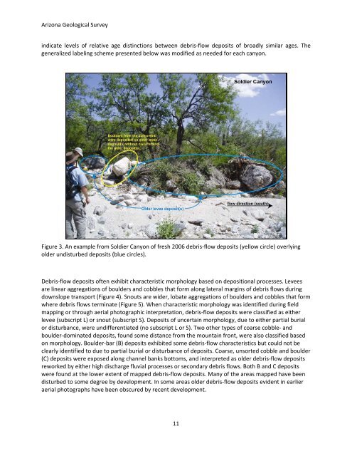
Figure 3. An example from Soldier Canyon of fresh 20<strong>06</strong> debris‐flow deposits (yellow circle) overlying<br />
older undisturbed deposits (blue circles).<br />
Debris‐flow deposits often exhibit characteristic morphology based on depositional processes. Levees<br />
are linear aggregations of boulders and cobbles that form along lateral margins of debris flows during<br />
downslope transport (Figure 4). Snouts are wider, lobate aggregations of boulders and cobbles that form<br />
where debris flows terminate (Figure 5). When characteristic morphology was identified during field<br />
mapping or through aerial photographic interpretation, debris‐flow deposits were classified as either<br />
levee (subscript L) or snout (subscript S). Deposits of uncertain morphology, due to either partial burial<br />
or disturbance, were undifferentiated (no subscript L or S). Two other types of coarse cobble‐ and<br />
boulder‐dominated deposits, found some distance from the mountain front, were also classified based<br />
on morphology. Boulder‐bar (B) deposits exhibited some debris‐flow characteristics but could not be<br />
clearly identified to due to partial burial or disturbance of deposits. Coarse, unsorted cobble and boulder<br />
(C) deposits were exposed along channel banks bottoms, and interpreted as older debris‐flow deposits<br />
reworked by either high discharge fluvial processes or secondary debris flows. Both B and C deposits<br />
were found at the lower extent of mapped debris‐flow deposits. Many of the areas mapped have been<br />
disturbed to some degree by development. In some areas older debris‐flow deposits evident in earlier<br />
aerial photographs have been obscured by recent development.<br />
11


