

Arizona Geological Survey OPEN-FILE REPORT OFR 08-06
Arizona Geological Survey OPEN-FILE REPORT OFR 08-06
Arizona Geological Survey OPEN-FILE REPORT OFR 08-06

You also want an ePaper? Increase the reach of your titles
YUMPU automatically turns print PDFs into web optimized ePapers that Google loves.
<strong>Arizona</strong> <strong>Geological</strong> <strong>Survey</strong><br />
A direct comparison of study canyon morphometrics with reported data describing debris‐flow prone<br />
basins is difficult, as reported data are either from regions with very different climates (Wilford and<br />
others, 2004) or from highly disturbed basins (Cannon and Gartner, 2005). In addition, all of the study<br />
canyons have evidence of past debris‐flow activity. These data are more useful for assessing the<br />
influence of basin size and channel gradient on debris‐flow conveyance and potential runout distances.<br />
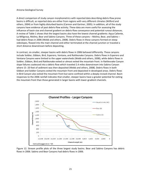
A review of Table 1 shows that the largest basins also have the lowest channel gradients: Aqua Caliente,<br />
La Miligrosa, Molino, Bear and Sabino Canyons. Three of these canyons – Molino, Bear, and Sabino –<br />
had debris flows in 20<strong>06</strong> (Webb and others, 20<strong>08</strong>). Debris flows in these canyons formed on steep<br />
sideslopes, flowed into the main channel and either terminated at the channel junction or traveled a<br />
short distance downstream before depositing.<br />
In contrast, six smaller, steeper basins with debris flows in 20<strong>06</strong> behaved differently. These canyons<br />
include Soldier, Gibbon, Bird, Esperero, Ventana, and Rattlesnake Canyons. Debris flows in Esperero and<br />
Ventana Canyons were limited to the upper watersheds (Webb and others, 20<strong>08</strong>), while debris flows in<br />
Soldier, Gibbon, Bird and Rattlesnake exited or almost exited the mountain front. In Rattlesnake Canyon<br />
slope failures coalesced into a debris flow which traveled 2.4 miles downstream into Sabino Canyon<br />
where 15 ‐20 feet of sediment was then deposited (Webb and others, 20<strong>08</strong>). Debris flows in both<br />
Gibbon and Soldier Canyons exited the mountain front and deposited in developed areas. Debris flows<br />
in Bird Canyon also exited the mountain front but were confined within a deeply incised channel. Basin<br />
responses to the 20<strong>06</strong> rainfall indicates that smaller, steeper basins have a greater potential for exiting<br />
the mountain front than those generated in larger basins with lower‐gradient channels.<br />
Figure 12. Stream profile plots of the three largest study basins. Bear and Sabino Canyons has debris<br />
flows in 20<strong>06</strong>. Sabino and Bear Canyons had debris flows in 20<strong>06</strong>.<br />
21


