Changes in the Emergent Plant Community of Netley-Libau Marsh ...
Changes in the Emergent Plant Community of Netley-Libau Marsh ...
Changes in the Emergent Plant Community of Netley-Libau Marsh ...

You also want an ePaper? Increase the reach of your titles
YUMPU automatically turns print PDFs into web optimized ePapers that Google loves.
Grosshans et al.<br />
Vegetation change <strong>in</strong> <strong>Netley</strong>-<strong>Libau</strong> <strong>Marsh</strong><br />
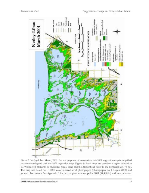
Figure 5. <strong>Netley</strong>-<strong>Libau</strong> <strong>Marsh</strong>, 2001. For <strong>the</strong> purposes <strong>of</strong> comparison this 2001 vegetation map is simplified<br />
to a common legend with <strong>the</strong> 1979 vegetation map (Figure 4). Both maps are based on a region selected <strong>in</strong><br />
1979 bordered primarily by municipal roads, dikes and <strong>the</strong> Brokenhead River to <strong>the</strong> nor<strong>the</strong>ast (25,773 ha).<br />
The map was based on 1:10,000 color <strong>in</strong>frared aerial photographs (photography on 3 August 2001) and<br />
ground observations. See Appendix 3 for <strong>the</strong> complete area mapped <strong>in</strong> 2001 (34,480 ha) with area estimates.<br />
DMFS Occasional Publication No. 4 15