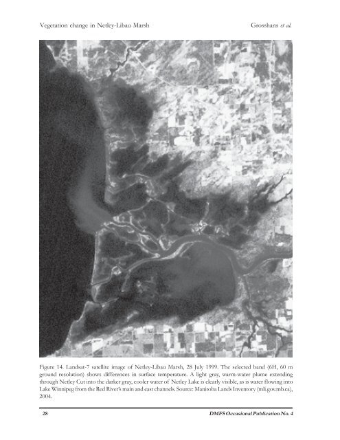
Vegetation change <strong>in</strong> <strong>Netley</strong>-<strong>Libau</strong> <strong>Marsh</strong> Grosshans et al. Figure 14. Landsat-7 satellite image <strong>of</strong> <strong>Netley</strong>-<strong>Libau</strong> <strong>Marsh</strong>, 28 July 1999. The selected band (6H, 60 m ground resolution) shows differences <strong>in</strong> surface temperature. A light gray, warm-water plume extend<strong>in</strong>g through <strong>Netley</strong> Cut <strong>in</strong>to <strong>the</strong> darker gray, cooler water <strong>of</strong> <strong>Netley</strong> Lake is clearly visible, as is water flow<strong>in</strong>g <strong>in</strong>to Lake W<strong>in</strong>nipeg from <strong>the</strong> Red River’s ma<strong>in</strong> and east channels. Source: Manitoba Lands Inventory (mli.gov.mb.ca), 2004. 28 DMFS Occasional Publication No. 4
Grosshans et al. Vegetation change <strong>in</strong> <strong>Netley</strong>-<strong>Libau</strong> <strong>Marsh</strong> channel was breached dur<strong>in</strong>g <strong>the</strong> Red River flood <strong>of</strong> 1950 but was closed aga<strong>in</strong> by 1963 (Unies Ltd. 1972). By 1970, <strong>the</strong> breach was aga<strong>in</strong> open and it rema<strong>in</strong>s so today (Figure 13). Presently, <strong>the</strong> Cut is about 400 m wide, be<strong>in</strong>g broader than <strong>the</strong> Red River at that po<strong>in</strong>t. A satellite image <strong>of</strong> sou<strong>the</strong>rn <strong>Netley</strong> Lake shows prom<strong>in</strong>ent <strong>the</strong>rmal plumes extend<strong>in</strong>g far <strong>in</strong>to <strong>the</strong> lake as a result <strong>of</strong> <strong>in</strong>trusion by warm river water (Figure 14). The gradual widen<strong>in</strong>g <strong>of</strong> <strong>the</strong> Cut over time, and <strong>the</strong> conspicuous sediment deposits <strong>in</strong> <strong>Netley</strong> Lake at <strong>the</strong> mouth <strong>of</strong> <strong>the</strong> Cut (Figure 13) support a conclusion that <strong>Netley</strong> Cut has altered <strong>the</strong> flow pattern <strong>of</strong> <strong>the</strong> Red River (Figure 11). Some proportion <strong>of</strong> <strong>the</strong> Red River flow is now routed rout<strong>in</strong>ely through <strong>Netley</strong> Lake, ra<strong>the</strong>r than follow<strong>in</strong>g its traditional ma<strong>in</strong> channel through <strong>the</strong> center <strong>of</strong> <strong>the</strong> marsh complex to discharge <strong>in</strong>to Lake W<strong>in</strong>nipeg east <strong>of</strong> Hardman Lake (Figure 3). As a meander<strong>in</strong>g prairie river, <strong>the</strong> Red River has never been well suited to navigation by large boats. Efforts at improv<strong>in</strong>g its channel by dredg<strong>in</strong>g <strong>the</strong> bottom, especially at <strong>the</strong> mouth <strong>in</strong>to Lake W<strong>in</strong>nipeg, began <strong>in</strong> early 1884 with <strong>the</strong> construction <strong>of</strong> a tugboat and dredg<strong>in</strong>g scow (W<strong>in</strong>nipeg Daily Times, 6 June 1884). River dredg<strong>in</strong>g generally occurred annually from 1960 to 1998 when <strong>the</strong> extent <strong>of</strong> work was reduced <strong>the</strong>n elim<strong>in</strong>ated entirely <strong>in</strong> 1999 (KGS Group 2002). No dredg<strong>in</strong>g has occurred s<strong>in</strong>ce 1999. Overall, changes s<strong>in</strong>ce 1998 <strong>in</strong> <strong>the</strong> bottom pr<strong>of</strong>ile at dredg<strong>in</strong>g locations have been on <strong>the</strong> order <strong>of</strong> a few cm but up to 1 m <strong>in</strong> some locations (KGS 2002). It is claimed that, without dredg<strong>in</strong>g, <strong>the</strong> mouth <strong>of</strong> <strong>the</strong> Red River is becom<strong>in</strong>g alarm<strong>in</strong>gly shallow, be<strong>in</strong>g 2 m <strong>in</strong> 2002 compared to 6 m <strong>in</strong> 1982 (International Coalition 2002). Studies <strong>of</strong> <strong>the</strong> potential impacts <strong>of</strong> no dredg<strong>in</strong>g have considered loss <strong>of</strong> navigation to recreational, cargo, and fish<strong>in</strong>g vessels; and local flood<strong>in</strong>g due to ice jams <strong>in</strong> a shallower river channel. They have not considered <strong>the</strong> potential ecological effects on <strong>Netley</strong>-<strong>Libau</strong> <strong>Marsh</strong>. Specifically, lack <strong>of</strong> dredg<strong>in</strong>g at <strong>the</strong> mouth <strong>of</strong> <strong>the</strong> Red River – which represented over 75% <strong>of</strong> <strong>the</strong> total dredg<strong>in</strong>g prior to 1999 (KGS 2002) – will cause <strong>the</strong> water to take alternate routes to Lake W<strong>in</strong>nipeg, <strong>in</strong>clud<strong>in</strong>g ones through <strong>the</strong> marsh via <strong>the</strong> <strong>Netley</strong> Cut. A larger volume <strong>of</strong> water pass<strong>in</strong>g through <strong>the</strong> Cut will deliver larger quantities <strong>of</strong> river-borne silt, debris, nutrients, and pollutants to <strong>the</strong> marsh. In o<strong>the</strong>r words, <strong>the</strong> lack <strong>of</strong> Red River dredg<strong>in</strong>g probably exacerbates <strong>the</strong> impacts <strong>of</strong> <strong>the</strong> Cut on <strong>Netley</strong> Lake. The river may also erode new channels to Lake W<strong>in</strong>nipeg, with <strong>the</strong> result that a larger number <strong>of</strong> connections between <strong>Netley</strong>-<strong>Libau</strong> <strong>Marsh</strong> and <strong>the</strong> lake will allow greater water movement between <strong>the</strong>m, especially dur<strong>in</strong>g storms (Figure 11). The <strong>in</strong>creases <strong>in</strong> water velocity, water flow volume, and nutrient load<strong>in</strong>g from <strong>the</strong> Red River and Lake W<strong>in</strong>nipeg are likely contribut<strong>in</strong>g factors to <strong>the</strong> decl<strong>in</strong>e <strong>in</strong> submersed and emergent macrophytes, erosion <strong>of</strong> smaller channels, uplands, and emergent islands, and <strong>in</strong>creases <strong>in</strong> water column turbidity and algal blooms <strong>in</strong> <strong>Netley</strong> Lake (Figure 11). The movement <strong>of</strong> river water preferentially through <strong>the</strong> western unit <strong>of</strong> <strong>Netley</strong>-<strong>Libau</strong> <strong>Marsh</strong>, via <strong>Netley</strong> Cut, could expla<strong>in</strong> why <strong>the</strong> magnitude <strong>of</strong> changes is more dramatic than <strong>in</strong> <strong>the</strong> easternmost unit <strong>of</strong> <strong>the</strong> marsh (Folster Lake), which has no connections with <strong>the</strong> Red River (Figure 3). The Red River watershed covers an area <strong>of</strong> about 127,000 km 2 , one <strong>of</strong> <strong>the</strong> largest <strong>in</strong> North America. Several urban and <strong>in</strong>dustrial centers, vast areas <strong>of</strong> chemical-<strong>in</strong>tensive cereal agriculture, and numerous po<strong>in</strong>t and nonpo<strong>in</strong>t sources <strong>of</strong> animal manure occur throughout <strong>the</strong> watershed, so it is perhaps not surpris<strong>in</strong>g that <strong>the</strong> river’s water quality is threatened. Analyses <strong>of</strong> water samples collected from <strong>the</strong> river near Selkirk, between 1978 and 1999, reveal <strong>in</strong>creases <strong>of</strong> 29% and 58% for total nitrogen and total phosphorus, respectively (Jones and Armstrong 2001). Both are essential nutrients which can stimulate algal growth <strong>in</strong> receiv<strong>in</strong>g waters. The high nutrient load <strong>of</strong> <strong>the</strong> Red River, routed <strong>in</strong>to <strong>Netley</strong>-<strong>Libau</strong> <strong>Marsh</strong> to a greater extent than <strong>in</strong> <strong>the</strong> past, as a result <strong>of</strong> <strong>the</strong> <strong>Netley</strong> Cut and lack <strong>of</strong> dredg<strong>in</strong>g at <strong>the</strong> mouth <strong>of</strong> <strong>the</strong> river, could be a factor contribut<strong>in</strong>g to algal growth <strong>in</strong> <strong>Netley</strong>-<strong>Libau</strong> <strong>Marsh</strong> (Figure 11). Excessive algal growth due to nutrient enrichment can lead directly to <strong>the</strong> loss <strong>of</strong> aquatic plants <strong>in</strong> at least two ways. First, epiphytic algae becomes more abundant, form<strong>in</strong>g thick coat<strong>in</strong>gs which shade <strong>the</strong> host plants and compete with <strong>the</strong>m for water column nutrients (Phillips et al. 1978). Phytoplankton blooms fur<strong>the</strong>r decrease subsurface light below <strong>the</strong> po<strong>in</strong>t <strong>of</strong> photosyn<strong>the</strong>tic compensation so submersed plants eventually die out. The gradual loss <strong>of</strong> submersed vegetation, whose roots help to stabilize sediments DMFS Occasional Publication No. 4 29