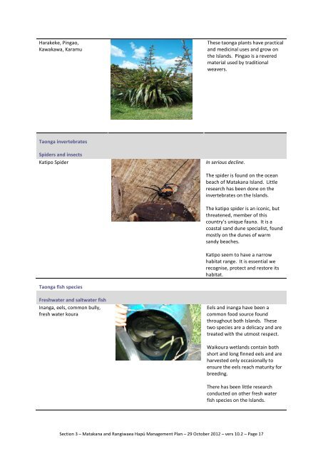
Harakeke, Pingao, Kawakawa, Karamu These taonga plants have ...
Harakeke, Pingao, Kawakawa, Karamu These taonga plants have ...
Harakeke, Pingao, Kawakawa, Karamu These taonga plants have ...

Create successful ePaper yourself
Turn your PDF publications into a flip-book with our unique Google optimized e-Paper software.
<strong>Harakeke</strong>, <strong>Pingao</strong>,<br />
<strong>Kawakawa</strong>, <strong>Karamu</strong><br />
<strong>These</strong> <strong>taonga</strong> <strong>plants</strong> <strong>have</strong> practical<br />
and medicinal uses and grow on<br />
the Islands. <strong>Pingao</strong> is a revered<br />
material used by traditional<br />
weavers.<br />
Taonga invertebrates<br />
Spiders and insects<br />
Katipo Spider<br />
In serious decline.<br />
The spider is found on the ocean<br />
beach of Matakana Island. Little<br />
research has been done on the<br />
invertebrates on the Islands.<br />
The katipo spider is an iconic, but<br />
threatened, member of this<br />
country’s unique fauna. It is a<br />
coastal sand dune specialist, found<br />
mostly on the dunes of warm<br />
sandy beaches.<br />
Katipo seem to <strong>have</strong> a narrow<br />
habitat range. It is essential we<br />
recognise, protect and restore its<br />
habitat.<br />
Taonga fish species<br />
Freshwater and saltwater fish<br />
Inanga, eels, common bully,<br />
fresh water koura<br />
Eels and inanga <strong>have</strong> been a<br />
common food source found<br />
throughout both Islands. <strong>These</strong><br />
two species are a delicacy and are<br />
treated with the utmost respect.<br />
Waikoura wetlands contain both<br />
short and long finned eels and are<br />
harvested only occasionally to<br />
ensure the eels reach maturity for<br />
breeding.<br />
There has been little research<br />
conducted on other fresh water<br />
fish species on the Islands.<br />
Section 3 – Matakana and Rangiwaea Hapū Management Plan – 29 October 2012 – vers 10.2 – Page 17
Tamure/snapper, Flounder,<br />
Kahawai, Yellow Eyed Mullet,<br />
Kingfish, Grey Mullet, Trevally,<br />
Gurnard, Parore, Stargazers,<br />
Stingrays, Bronze Whalers<br />
Many of New Zealand’s saltwater<br />
fish stocks are in decline.<br />
<strong>These</strong> salt water species are found<br />
around the Islands and are caught<br />
seasonally throughout the year.<br />
Taonga bird species<br />
Migratory and other birds<br />
Matuku – Australasian Bittern<br />
(Botaurus poiciloptilus)<br />
This is a nationally endangered<br />
species.<br />
This bird lives in shallow, densely<br />
vegetated wetlands.<br />
It hides among raupo reeds and<br />
scrub.<br />
They hunt fish, frogs, eels, mice<br />
and young birds. Their numbers<br />
<strong>have</strong> fallen due to drainage of<br />
wetlands. They are found in<br />
wetlands of Matakana Island.<br />
Kotuku – White Heron<br />
The Kotuku or White Heron is<br />
extremely rare.<br />
Kotuku had mythical status for<br />
Maori because of their rarity and<br />
beauty. This beautiful bird visits<br />
Matakana on rare occasions.<br />
Kuaka/Hakakao – Bar-tailed<br />
godwits – known locally as<br />
Curlews.<br />
(Limosa lapponica)<br />
Bar-tailed godwits are the most<br />
common Arctic migrant to New<br />
Zealand. They make the longest<br />
non-stop flight of all birds –11,000<br />
kilometres from Alaska to New<br />
Zealand in only 5-6 days. They are<br />
found in coastal roosts around the<br />
Islands. <strong>These</strong> birds <strong>have</strong> been a<br />
common food source for the Hapū<br />
for generations however, due to<br />
loss of habitat, both locally and<br />
internationally, this species is in<br />
decline and the need to protect<br />
this habitat is paramount to<br />
ensure their continued presence<br />
within the eco-system is<br />
maintained.<br />
Section 3 – Matakana and Rangiwaea Hapū Management Plan – 29 October 2012 – vers 10.2 – Page 18
Ruru (Morepork)<br />
The Ruru is widely found<br />
throughout the Islands’ pine<br />
forests and wetland margins.<br />
They live in native and exotic<br />
forest and in open country. They<br />
require mature trees for shelter<br />
and nesting. Ruru roosts by day in<br />
thick vegetation, preferably in<br />
gullies with plenty of shelter.<br />
Migratory and other birds<br />
Moho-pereru – Banded Rail<br />
(Gallirallus philippensis)<br />
Tuturiwhatu (NZ Dotterel)<br />
A nationally endangered species.<br />
This bird is related to the weka,<br />
but is slimmer, and can fly.<br />
Banded rails inhabit dense rush,<br />
salt marsh or mangrove that<br />
surrounds freshwater and coastal<br />
waterways. Their diet includes<br />
land snails and coastal molluscs,<br />
crabs, spiders, insects and worms.<br />
They also eat berries and seeds.<br />
A nationally endangered species.<br />
NZ dotterels are shorebirds,<br />
usually found on sandy beaches<br />
and sandspits or feeding on tidal<br />
estuaries. NZ dotterels can be<br />
hard to see, because their<br />
camouflage. Matakana Island is<br />
New Zealand’s most successful<br />
breeding site with a successful<br />
partnership between DOC and the<br />
community.<br />
Tui<br />
Tui are unique and prevalent<br />
throughout New Zealand.<br />
They belong to the honeyeater<br />
family and feed mainly on nectar<br />
from flowers of native <strong>plants</strong>. Tui<br />
are important pollinators of native<br />
trees. Tui live where there is a<br />
balance of ground cover, shrubs<br />
and trees. Tui are found<br />
throughout Matakana Island<br />
Section 3 – Matakana and Rangiwaea Hapū Management Plan – 29 October 2012 – vers 10.2 – Page 19
Taonga mammals<br />
Endangered species<br />
Pekapeka (Long-tailed bat)<br />
Chalinolobus tuberculata<br />
The long-tailed bat (also known as<br />
the wattled bat) is found throughout<br />
New Zealand.<br />
This species is thought to visit<br />
seasonally around Waikoura<br />
wetlands of the north-western part<br />
of the Island.<br />
In the 1800s, long-tailed bats were<br />
found in colonies of hundreds or<br />
thousands throughout New Zealand.<br />
In 1930 they became scarce in many<br />
areas due to loss of habitat.<br />
Taonga Mammals<br />
Wild boar<br />
Wild boar are an important food<br />
source for our people. Although<br />
they are treated as pests in some<br />
areas, they are managed<br />
sustainably to ensure stock<br />
numbers are maintained.<br />
Section 3 – Matakana and Rangiwaea Hapū Management Plan – 29 October 2012 – vers 10.2 – Page 20
Water<br />
Water (Te Waiora a Tane) is the source of all life that has sustained and nurtured Hapū for<br />
generations. All living things depend on the balance and harmony of these water bodies. There is a<br />
symbiotic relationship between Ahi kaa, Te Waiora a Tane and Tangaroa. Each relies on the other to<br />
nourish, replenish and sustain the resources we depend on for our sustenance. Our connection to<br />
these water sources is intrinsically linked through whakapapa and is a starting point for all life that<br />
exists on the Islands.<br />
The recently ratified Mataatua Declaration on Water, of Te Hono o Mataatua, The Mataatua<br />
Assembly (which Ngai Te Rangi is a member iwi of) states:<br />
We do hereby: Declare that is our desire and wish to continue to retain full, exclusive and undisturbed<br />
possession of our ancestral waters including rivers, streams, lakes, aquifers, groundwater, wetlands,<br />
tributaries and geothermal features and resources; and their beds and banks, and the airspace above<br />
these resources.<br />
The Hapū acknowledge these relationships and view our inherited role as kaitiaki of all the<br />
associated water bodies on and surrounding both Islands.<br />
Fisheries<br />
The Hapū of Rangiwaea and Matakana seek confirmation for the following legislative documents: -<br />
Taiapure<br />
Twenty years ago, we actively pursued the establishment of a Taiapure and although the process<br />
proved too challenging for our Hapū, we support the notion that Taiapure would give our Hapū a<br />
greater say in the management of our traditionally important areas by advising the Minister of<br />
Fisheries on Regulations to control all types of fishing including commercial.<br />
Mataitai<br />
We seek the authority of the Ministry of Fisheries to manage and control the non commercial<br />
harvest of kai moana. As Tangata Kaitiaki, we require the ability to recommend By-laws to manage<br />
customary food gathering and sustainable management practices. We also acknowledge the<br />
permanency of Mataitai Reserves.<br />
Marine & Coastal Area (Takutai Moana), Act 2011<br />
Submissions by Tangata Whenua of the Islands were lodged for the Foreshore & Seabed Act 2004<br />
that were subsequently repealed in 2011. We intend to make application that recognizes the Mana<br />
Tukuiho of our Hapū for our marine and coastal area, and provide for the exercise of customary<br />
interests in the common marine and coastal area and give legal expression to customary interests<br />
and intrinsic worth.<br />
The increasing numbers of recreational fishers and boats in and around the Islands pose a threat to<br />
sustainable fish stock numbers. Recreational fishers and commercial fishing ventures are prevalent<br />
throughout the whole year within the Tauranga Harbour and throughout the coastal margins of Te<br />
Moananui a Toi.<br />
Commercial fishing in the inner harbour is limited to only two operators. Yet it is with some<br />
indignation that Hapū members are forced to compete with commercial nets and crab pots in a<br />
Section 3 – Matakana and Rangiwaea Hapū Management Plan – 29 October 2012 – vers 10.2 – Page 21
‘take’ that draws heavily on the limited resource in and around the Islands. The commercial<br />
operators are legally permitted to pursue these activities – which are often in direct conflict with<br />
customary fishing practises exercised by Hapū members.<br />
The issue of dwindling fish stocks is not isolated to our Islands. But because of our location and<br />
dependency on kaimoana to sustain our Hapū, we feel the impacts severely. We are committed to<br />
restoring the breeding grounds in and around our Islands. The restoration of riparian margins on the<br />
Islands, and the improved water quality that results, has a direct impact on the restoration of fish<br />
breeding grounds.<br />
Aquaculture has been highlighted as an aspiration and natural fit for the Hapū of the Islands to<br />
develop as part of our economic goals.<br />
Air<br />
The Hapū of Matakana and Rangiwaea <strong>have</strong> an integral relationship with air. Our relationship<br />
recognises the mana of Tawhirimatea (Atua o Nga Hau e Wha) in its purest essence, and the<br />
inherent tapu force and power that are mauriora – ‘the breath of life.’<br />
Our Islands are situated along the general flight path of the Tauranga airport so we are constantly<br />
subjected to noise pollution. We object to the intrusion of low flying aircraft over our air space and<br />
to the ad-hoc activity of aircrafts practising landing manoeuvres on our highly significant coastal<br />
areas that also poses fire risks to the forestry plantations. We also assert our rights to own air waves<br />
and to broadcast from our own media, such as radio stations.<br />
Threats from Poorly Constructed Policies<br />
Threats from poorly constructed local government policies <strong>have</strong> allowed council-permitted activities<br />
to negatively affect the Hapū and Islands. The key issues are listed below.<br />
Sewage Pipeline Discharge<br />
The pipeline has been discharging sewage into the ocean off the barrier arm since the 1960’s, and<br />
continues to this day. This directly compromises the coastal environment and poisons our kai<br />
moana. We strongly object to this activity, and want it to cease.<br />
Horse Trekking<br />
Without proper consultation with Hapū, the local council recently established the Reserves and<br />
Facilities By-laws to allow horse trekking across to Matakana via the Matahui crossing. We object<br />
strongly to the passing of this policy and demand to be consulted, and <strong>have</strong> meaningful engagement<br />
with Council before such By-laws are passed.<br />
Boats and Ski Lanes<br />
For over 30 years local government has maintained a ski lane policy for Matakana, Rangiwaea and<br />
Motuhoa Islands that we consider irresponsible and dangerous. Against our will, we are forced to<br />
endure jet skis and jet boats blasting through small tracts of water dangerously close to where we<br />
conduct everyday family activities. There <strong>have</strong> already been 2 water-related deaths. We know of no<br />
comparable body of water in New Zealand where this would be considered legal, let alone safe. We<br />
object strongly to having our families’ safety, peace and well being compromised by poorly<br />
constructed policies.<br />
Section 3 – Matakana and Rangiwaea Hapū Management Plan – 29 October 2012 – vers 10.2 – Page 22
Esplanade Reserves<br />
There are several esplanade reserves at various locations on the Islands’ coastal margins. <strong>These</strong><br />
reserves <strong>have</strong> been created with no direct engagement with our Hapū. The new Western Bay of<br />
Plenty District Plan 2012 proposes “an esplanade reserve wider than 20m in width shall be set aside<br />
on: the whole of Matakana Island”. This is a blatant example of raupatu in 2012 and we do not<br />
agree to this.<br />
Port of Tauranga Ltd<br />
The contribution the Port of Tauranga Ltd (the Port) has made to the local and national economy is<br />
acknowledged. Economic and environmental factors associated with the Port that negatively impact<br />
on our Islands and moana are as follows: -<br />
• Dredging of the pipi beds on the main bank known as Te Paritaha o Te Awanui<br />
• Increased volume of container shipping traffic and lack of defined shipping lanes<br />
• Increased bio-security threats (invasive insects and organisms land and sea)<br />
• Increased pollution from ballast waters<br />
Dredging<br />
The Port has consents granted by Environment Bay of Plenty to deepen and widen the shipping<br />
channels in the Tauranga harbour. This involves removing boulders from under Mauao, dredging Te<br />
Paritaha main bank and scouring Panepane – located at the Tauranga Harbour entrance on<br />
Matakana Island. The aim of the expansion of Port activities is to increase the volume of port traffic<br />
and to allow bigger container ships into the Tauranga harbour. While conditions <strong>have</strong> been<br />
negotiated between the Port and local Iwi representatives, we believe the accumulative effect of<br />
this activity is extremely detrimental for Te Awanui. In addition, much of the scientific evidence<br />
submitted by the Port relies on unknown variables that do not provide certainty.<br />
Shipping Lanes<br />
The absence of shipping lanes in New Zealand highlights the tension and risks that exist between<br />
economic interests and the integrity of the environment. The protest action at the Auckland wharf<br />
resulted in container ships being diverted to Tauranga. We saw this as another threat and potential<br />
catastrophe as container ships vied for access to Tauranga Ports and lined up outside Tuhua Island<br />
(marine reserve).<br />
“The New Zealand government has been informed of eleven (11) close calls or near missing regarding<br />
accidents – ranging from tankers to passenger vessels – since the Rena disaster happened just over a<br />
year ago. Marine experts insist that this exemplifies the need for more enforced control. This report<br />
comes at a time when the New Zealand Government are asking for obligatory shipping lanes for the<br />
country”. Reference: Maritime NZ October 2012<br />
Biosecurity<br />
We need stricter border controls to contain foreign, invasive, viruses that threaten native <strong>plants</strong> and<br />
our horticulture and agriculture ventures. The recent grounding of the Rena highlighted the risks<br />
and dangers of foreign and invasive species entering via the eastern coastline. We support a regime<br />
of bio-security testing and monitoring to mitigate any potential threats.<br />
Section 3 – Matakana and Rangiwaea Hapū Management Plan – 29 October 2012 – vers 10.2 – Page 23
Ballast Waters<br />
The increased volume of ships to Tauranga Harbour increases the volume and potential of polluted<br />
ballast water being spilled accidentally or deliberately into the marine environment.<br />
Rena Monrovia Grounding<br />
The grounding of the Rena in October 2011 highlighted the risks and dangers of weak government<br />
policies and protocols that contributed to the biggest recorded environmental disaster in New<br />
Zealand.<br />
The oil spill and consequent spread of debris along the ocean side of the barrier arm affected our<br />
people spiritually, physically and mentally. It brought to the fore the true notion of kaitiakitanga,<br />
rangatiratanga and kotahitanga concepts. The Whanau, Hapū and Iwi banded together from day 1<br />
to facilitate the clean up and we anticipate a 2-3 year long term project to return the coastline to its<br />
pre-Rena state.<br />
The Rena Long-Term Environmental Recovery Plan supported at local, regional and national levels,<br />
sets goals and objectives for the environmental recovery following the grounding. It describes the<br />
environmental issues and outlines the actions that will be undertaken to address them. Reference:<br />
Rena Long Term Environmental Recovery Plan 2012<br />
Matakana Island was identified as one of the 5 most impacted areas alongside Motiti Island, Maketu,<br />
Mauao/Papamoa and East Cape. The Rena Long Term Environment Recovery Plan highlights the<br />
importance of the role of Tangata Whenua in the affected areas and their partnership with<br />
government agencies, scientists and the like to facilitate projects to return the environment to its<br />
pre-Rena state.<br />
Organisations and projects<br />
The Matakana Island Marine Club – Incorporated Society<br />
The Society was created in 1998 to handle the challenges on Matakana arising from land-selling and<br />
development. The key objectives for the Marine Club include:<br />
• A forum that allowed Rangatahi/Pakeke to come together for korero/brainstorming<br />
• Applying Matauranga Maori principles, and providing a framework for our people<br />
• Facing up to the challenge of kaitiakitanga within a contemporary context<br />
• An entity that allows for sustainable economic development<br />
• Biodiversity concepts<br />
Although the objectives of the Marine Club remain, the Club has since focussed on environmental<br />
restoration projects. The members aim to restore and enhance the spiritual well-being of our<br />
moana, whenua and <strong>taonga</strong> tuku-iho. The Club sources funding from various agencies to restore<br />
areas of significance on the Islands. The Club also aims to maintain tikanga and kawa protocols<br />
pertaining to the matauranga taiao of Matakana and Rangiwaea.<br />
The entity has worked closely with landowners to restore wetlands and coastal areas on both<br />
Islands. In 2005, a 20-year project to restore 300 hectares of Riparian Habitats on the Islands was<br />
started. To date, we <strong>have</strong> restored over 50 hectares of wetland and coastal margins.<br />
Section 3 – Matakana and Rangiwaea Hapū Management Plan – 29 October 2012 – vers 10.2 – Page 24
The Club has identified a vital link in the transition of knowledge from one generation to the next<br />
through its relationship with the Te Kura o Te Moutere o Matakana – Te Kotukutuku and Te Kohanga<br />
Reo. The Club works with these organisations to develop an environmental curriculum that supports<br />
and nurtures sustainable management of nga <strong>taonga</strong> tuku iho for future generations.<br />
The Matakana Island Environmental Group<br />
The Matakana Island Environmental Group was established under the umbrella of the Matakana<br />
Island Marine Club in 2004. The primary aim was to address environmental issues and to enhance<br />
and restore the biodiversity of the Islands.<br />
Te Akakura/Matakana Island Nursery Project<br />
Te Akakura was set up to provide a source of local indigenous native <strong>plants</strong>. <strong>These</strong> are then used to<br />
restore, replenish and enhance our coastal margins, wetlands, waterways and sites of significance.<br />
The nursery is strategically placed next to our Kura. It provides employment and a platform for an<br />
environmental education kaupapa.<br />
With the successful development and ongoing management of Te Akakura/Matakana Island Nursery<br />
– The Marine Club has developed strong working relationships with the following;<br />
• Ngai Te Rangi Iwi<br />
• Nga Whenua Rahui<br />
• Blakely Pacific Limited<br />
• Tauranga Moana Maori Trust Board<br />
• The Department of Conservation<br />
• Environment Bay of Plenty Regional Council<br />
• Whangaparoa Coast Care Group<br />
• World Wide Fund<br />
New Zealand Dotterel (Tuturiwhatu) Protection Project<br />
Matakana Island is one of two important nesting grounds for the endangered New Zealand dotterel<br />
(tuturiwhatu). In 1992, the Department of Conservation (DOC) chose Matakana Island as a key<br />
breeding site for its Dotterel Recovery Programme. While the birds nest along three main areas,<br />
they can be found around the entire coastline of both Islands.<br />
The programme involves Hapū members employed by DOC to undertake predator control. They<br />
reduce the risks from human activities, monitor the birds and promote school visits around nesting<br />
sites. This project is internationally recognised and is one of the best of its kind in New Zealand.<br />
The Hamiora Whanau Trust Wetland<br />
The Hamiora Whanau Trust wetland has an area of approximately 2 hectares. It is the outlet point of<br />
one of the major wetlands on the Island. This wetland is a unique freshwater-estuarine environment<br />
and contains a diverse range of avi-fauna, vertebrates, and invertebrates including nationally<br />
threatened species. The biodiversity values of this wetland <strong>have</strong> been threatened by stock intrusion,<br />
soil erosion, and nutrient run-off and the suffocation by pest weeds – mainly willow and gorse.<br />
In late 2006 the Trust worked with Matakana Island Environment Group to put the wetland under a<br />
Nga Whenua Rahui Kawenata. The Hamiora whanau had for a long time, envisaged restoring their<br />
wetland back to its natural state to ensure future generations will <strong>have</strong> this precious <strong>taonga</strong>.<br />
Section 3 – Matakana and Rangiwaea Hapū Management Plan – 29 October 2012 – vers 10.2 – Page 25
The Hamiora Whanau Trust Wetland has also had a boardwalk installed to allow for easy access to<br />
the ‘little Island’ in the middle of the wetland. It is used as an educational tool for our kura, and<br />
allows easy access for monitoring of the wetland.<br />
Waihirere 11 Trust Wetland Restoration<br />
The Waihirere 11Trust Wetland has an area of approx 13 hectares. The current farmers were very<br />
keen to restore their wetland and protect and enhance the biodiversity. This is a large freshwater<br />
wetland containing a diverse range of avi-fauna, vertebrates and invertebrates species, including<br />
nationally-threatened species.<br />
The biodiversity values of this wetland <strong>have</strong> been threatened by stock intrusion, soil erosion,<br />
nutrient run-off, and has been suffocated by pest weeds - mainly willow and gorse. The willow has<br />
formed large dense ‘forests’ in the wetland. However, a flourishing native under storey of mainly<br />
Carex grass species, coprosmas and a little manuka are growing.<br />
The Matakana Island Environment Group helped form partnerships between the Trust and Bay of<br />
Plenty Regional Council. In 2008 the Trust signed up to an environmental program with Bay of<br />
Plenty Regional Council and a Nga Whenua Rahui Kawenata to start the restoration project.<br />
Matakana Island Environment Group facilitated and implemented the restoration project.<br />
Opureora Wetland Restoration<br />
The Opureora Wetland is a highly modified palustrine wetland system that is approximately one<br />
hectare in size. Intensive grazing has reduced the native plant species to Carex species with<br />
emergent Baumea articulate. The degradation of these native <strong>plants</strong> negatively affected the small<br />
juvenile eels that used this wetland system as a source of refuge. This also had an effect on the bird<br />
life that relied on these areas for food, especially the Matuku (Australasian bittern) which is seen on<br />
numerous occasions when water levels are high.<br />
This area is of particular importance to Hapū both culturally and environmentally. It is the only<br />
known site on Matakana Island that supports such large numbers of juvenile eels which migrate into<br />
the wetland through the Waipuna (spring that is connected to the inner harbour via alluvial vents).<br />
Without this area many of our Kaumatua say the numbers of eels found on Matakana Island would<br />
become scarce and disrupt the balance of wetland biodiversity.<br />
Section 3 – Matakana and Rangiwaea Hapū Management Plan – 29 October 2012 – vers 10.2 – Page 26
Murray Orchard Trust<br />
This Palustrine wetland system is a five hectare block that runs through a twelve hectare kiwifruit<br />
orchard with a nine hectare livestock grazing on the outer edges of the western wetland system.<br />
This wetland system is one of the main tributaries that feed into the estuary area (Te Uretureture)<br />
which is the main breeding ground for most of the estuarine fish species caught in the Tauranga<br />
harbour.<br />
Intensive unsustainable land practices, including agriculture and horticulture, <strong>have</strong> contributed to<br />
substantially decreasing fish numbers in this area. However, native plant species such as Jointedtwig<br />
rush and Baumea articulate are scattered in clumps throughout the wetland. This highly<br />
modified wetland is ecologically important and forms a natural corridor, especially for the juvenile<br />
short and long fin eels that use these sites as refuges.<br />
Reputable scientists and researchers recognise the uniqueness of our wetlands, freshwater, coastal<br />
and inter-tidal zones around the Islands. Their research combined with Matauranga Maori shows<br />
the biodiversities of these Islands to be extremely vulnerable. This environment is not only<br />
important to us, but to the entire country.<br />
Restoration of Contaminated Lands<br />
It is well documented that as a result of the toxic waste left from from the Mill tanalising plant, our<br />
people are facing ongoing health challenges. Although our land mass is relatively small, our Islands<br />
<strong>have</strong> disproportionately large contaminated sites due to a variety of activities. The chemicals and<br />
toxins are the same as those used at similar mill sites throughout New Zealand. Our Hapū want all<br />
contaminated sites on the Islands cleaned up. We intend to work closely with the relevant<br />
authorities to achieve this. From a cultural, social and health perspective, we will not be satisfied<br />
until the contaminated sites are fully restored and cleansed.<br />
Our identity as a people is intrinsically connected with our environment. We whakapapa to these<br />
Islands and this continues to shape our view of the world and our place in it. We lead self sufficient<br />
lifestyles that draw on the resources of our environment. To be Tangata Whenua, indigenous, and<br />
Islanders, means we <strong>have</strong> unique characteristics. The following quotes encapsulate the identity and<br />
culture of our Hapū.<br />
I <strong>have</strong> been here forever . . . through my tupuna. I will continue to be here through the coming<br />
generations. I belong here and live here because this is where I feel strong. My tupuna are here and<br />
this is home . . . Our history and stories are etched all over the whenua. Those stories make the<br />
Islands alive for me . . . Reference: Cultural Values Assessment, Taingahue, N. (2011)<br />
We are a resourceful and fiercely independent breed of people who can deliver our own babies, who<br />
grow up safe and secure within the extended family of Matakana. Reference: Cultural Values<br />
Assessment, Kuka, T. (2011)<br />
Population<br />
The following graph shows the population according to age. (Table 1)<br />
Section 3 – Matakana and Rangiwaea Hapū Management Plan – 29 October 2012 – vers 10.2 – Page 27
The following graph (Table 2) shows the population according to male and female and age. A<br />
total of 143 residents are Tane and 120 are Wahine.<br />
Many who live on the Islands <strong>have</strong> done so all their lives. We <strong>have</strong> a generational relationship<br />
with the Island that connects us with our past, our present and our future.<br />
Population challenges<br />
The population of Matakana and Rangiwaea Island has steadily declined since the 2001 census.<br />
We expect this decline to reverse as a result of Hapū establishing papakāinga and gaining<br />
funding for social and other housing projects.<br />
Meantime, as noted in graph 1, approximately 7 per cent of our population is over 65 years.<br />
With our population low, we are not a high priority for receiving government support. We tend<br />
to receive limited local and central government sponsored social services.<br />
Also, given the low number of permanent residents on Matakana, some developers are creating<br />
pressure to subdivide land on the barrier arm for ‘lifestyle living.’ For hundreds of years Hapū<br />
Section 3 – Matakana and Rangiwaea Hapū Management Plan – 29 October 2012 – vers 10.2 – Page 28
members along the barrier arm <strong>have</strong> lived without neighbours. Any substantial increase in<br />
population will affect the social fabric of the Island, especially given that nearby residents are almost<br />
all Hapū members.<br />
Additionally, the most condensed housing of Hapū members is on the harbour-side. If the barrier<br />
arm was allowed to be developed, there is a potential for creating a ‘them and us,’ situation – ethnic<br />
and other class distinctions. We do not believe this is conducive to creating social harmony.<br />
Marae<br />
Our Marae are fundamental to the retention and practise of our tikanga and kawa including our Reo<br />
Rangatira - Maori, and are integral to the wellbeing of our communities. Marae on both Islands are<br />
used as extensively for tangihanga, hura kohatu, huritau, wananga, hui a Hapū and for maintaining<br />
the social and cultural relationships of the Hapū.<br />
Matakana has two functioning marae (Opureora and Oruarahi) with Hapū representations from Ngai<br />
Tuwhiwhia and Ngai Tamawhariua respectively. The Hapū of Ngati Tauaiti is in the process of reestablishing<br />
its marae complex at Te Kutaroa.<br />
Rangiwaea Island has a functioning marae (Rangiwaea) and the Hapū representation is Te Whanau a<br />
Tauwhao. The Hapū of Te Ngare is also in the process of re-establishing their marae at Ōponui.<br />
Hauora Services<br />
Matakana Island has a health clinic, Te Awanui Hauora which provides health services. A General<br />
Practitioner and an assistant visit the clinic once a week. This service is particularly helpful for<br />
elderly residents, because it saves money and the inconvenience of travelling to the mainland for<br />
medical consultations.<br />
Te Awanui Hauora organises periodic visits from other suppliers of specialist medical and social<br />
services. For example, these include:<br />
• Nurses familiar with treating specific medical conditions (such as diabetes and asthma)<br />
• Community training - First Aid<br />
• Support services - provided by Inland Revenue and the Maori Land Court<br />
• Transport to mainland services – for breast screening and hospital appointments<br />
The Islands <strong>have</strong> their own accident and fire emergency response services. <strong>These</strong> services are<br />
staffed by volunteers. The majority of the residents on the Island are ‘friends’ of St John Ambulance<br />
and Helicopter services.<br />
Rangiwaea Island, with its small population, does not <strong>have</strong> a medical clinic or doctor’s service and<br />
residents prefer to engage with mainland health services. The residents are also required to meet<br />
any and all emergencies from within its own resourcing.<br />
People on the Islands are general healthy and <strong>have</strong> access to good food and nutrition. Because of<br />
low incomes, and lack of easy access to health care, people tend to ‘tough it out’ and do their best<br />
until the doctor arrives.<br />
Section 3 – Matakana and Rangiwaea Hapū Management Plan – 29 October 2012 – vers 10.2 – Page 29
However, the health challenges Hapū members experience are similar to those faced by Maori<br />
across the country generally. The difference is that these challenges are compounded by the<br />
isolation and higher charges to receive medical care and services. Typically prevalent health issues<br />
include:<br />
• Glue ear<br />
• Rheumatic fever<br />
• Rheumatoid arthritis<br />
• Gout<br />
• Diabetes<br />
• Breast cancer<br />
• Prostate cancer<br />
• Asthma and eczema<br />
• An increasing number of Kaumatua require specialist and respite care<br />
We <strong>have</strong> Hapū members who were exposed to chemicals from working at the timber tanalising plant<br />
on Matakana Island. Workers at comparable sites <strong>have</strong> suffered severe, long-term, medical<br />
conditions which equates with what is experienced by our Hapū members. Among our Hapū<br />
members, we <strong>have</strong> anecdotal evidence of birth defects, cancers and other problems typical of<br />
chemical poisoning.<br />
Education<br />
An educational challenge is that of maintaining educational facilities given our limited population<br />
and fluctuating birth rates. Returning families, combined with those currently on the Islands, will<br />
ensure enough tamariki to keep Te Kohanga Reo and the primary school open.<br />
Keeping these institutions going is crucial from a cultural and social perspective. A recent Hauora<br />
survey revealed approx 7% of adult residents are fluent in Te Reo Rangatira. Te Kohanga Reo, the<br />
primary school and the Marae on the Islands play a vital role in revitalising our language.<br />
We <strong>have</strong> 13 secondary school students who travel to the mainland and back each day for schooling.<br />
This is a particularly long day for our students, and the journey can be dangerous in rough weather.<br />
There are constraints around getting to and from barges on time. Living on the Islands affects the<br />
extent to which students can participate in extra-curricular activities on the mainland. Because of<br />
the ferry and barge timings, our students are unlikely to seek guidance from teachers, coaches,<br />
mentors and the like.<br />
Some families choose to send their teenagers to board on the mainland during their secondary<br />
school years. There are no easy answers for meeting these challenges and providing opportunities<br />
for our tamariki. The Hapū are working on plans to successfully address these issues.<br />
Housing and Papakāinga<br />
New housing is a priority for our communities. Hapū members currently living on the Islands wish to<br />
build more durable, low cost and environmentally friendly homes.<br />
Within a few years, leased land will become available and this presents new opportunities for those<br />
members who wish to return and live on whanau land. The challenge is to set up appropriate<br />
Section 3 – Matakana and Rangiwaea Hapū Management Plan – 29 October 2012 – vers 10.2 – Page 30
administration structures and access to lending facilities by our Hapū members, given the bulk of<br />
land is in multiple ownership. We aspire to the provision of Kaumatua housing. (Ref: Map of current<br />
dwellings on the Island)<br />
Papakāinga Development at Rangiwāea Island<br />
At the Annual General Meeting for Tauwhao Te Ngare Trust (known as the Trust) in 2008, a mandate<br />
from shareholders to investigate an extension to the current Papakāinga was initiated as there were<br />
services for one only remaining house site. The Papakāinga housing project is for the beneficial<br />
owners and their descendants who whakapapa to the Hapū of Tauwhao me Te Ngare at Rangiwāea<br />
Island. The provision of housing arrangements for its beneficiaries is identified as a key objective in<br />
the Trust Order.<br />
The Trust funded the project up until the resource consent process was ready to be undertaken.<br />
Planning work was completed by planners, Boffa Miskell and resource consent was provided by<br />
Western Bay of Plenty District Council to site an extra twenty two houses at Rangiwāea Island. A<br />
capability grant was provided by Te Puni Kokiri under “Social Housing Action Grant” to project<br />
manage the venture to Stage 2.<br />
In February 2011, the Trust was successful in securing funding grants from Housing New Zealand to<br />
provide homes for the Papakāinga.<br />
At this stage, development is focussed on four kaumatua units and one family home, including the<br />
installation of infrastructure for the new development. The current infrastructure has exhausted its<br />
capacity for the dwellings it currently services.<br />
Planning for the first stage of development will realise people moving to the Papakinga at Rangiwāea<br />
Island in June of 2013.<br />
Recreation and Sports<br />
The Matakana Island Recreation Club Incorporated (MIRCI) supports and hosts most recreational<br />
activities.<br />
The principle purpose of MIRCI, as described in the Constitution, is to promote, foster and<br />
encourage sporting and recreational activities within the Island community. The land on which the<br />
MIRCI complex is located, was gifted by the Owners of the block who whakapapa to the Islands. The<br />
provision of land by the Owners was part of a commitment to providing a space for activities that<br />
contributed positively to the social and cultural fabric of the Island communities.<br />
The MIRCI is an active organisation that provides a range of activities for a variety of sporting codes<br />
and recreational pastimes for its members and mainland visitors throughout the year. The "Club" as<br />
it is known, is a public licensed establishment. The membership of MIRCI is connected through<br />
whakapapa and observes tikanga maori in many of its practises to reflect its Maori community ethos.<br />
The challenges of the MIRCI relates to funding. Funding for sports teams across the age groups from<br />
primary aged through to adult teams to participate in competition grades on the mainland comes at<br />
significant cost. It is a source of pride for Islanders to participate in sporting events that require<br />
regular travel to the mainland and further afield. Wherever sporting fixtures are held, the support of<br />
Section 3 – Matakana and Rangiwaea Hapū Management Plan – 29 October 2012 – vers 10.2 – Page 31
the community is always prevalent as the Island community vacates to the mainland for the day to<br />
follow its teams.<br />
Social Perceptions of Prejudice and Relationships<br />
At times our relationships with business developers, local government and other agencies <strong>have</strong> been<br />
in conflict. This is because we <strong>have</strong> the perception that some decision-makers believe they are<br />
‘entitled to do what they want’ on our Islands. Many of our Hapū members feel under siege and<br />
overwhelmed by developers, central government, and local councils and their policies.<br />
Disproportionately High Rates for Services Received<br />
We <strong>have</strong> a small population and therefore a smaller rating base. However we are subject to similar<br />
rating regimes as those who live in rural areas on the mainland. We supply our own water, dispose<br />
of household rubbish and empty and maintain our own septic tank systems. We <strong>have</strong> few public<br />
amenities and services on the Islands compared to mainland rural communities, however we are still<br />
required to pay similar rate fees.<br />
At Rangiwaea Island, the Council does not provide the community with any services. The Rangiwaea<br />
community maintains its own roading, disposes of its household rubbish and empties and maintains<br />
its own septic tank systems. The Tauwhao Te Ngare Trust maintains potable water for the<br />
papakainga community and other residents are expected to maintain a bore and pump to service its<br />
own water needs. The wharf, pontoon and barge ramp were built by and maintained by the<br />
Tauwhao Te Ngare Trust for its Tangata Whenua residents.<br />
Section 3 – Matakana and Rangiwaea Hapū Management Plan – 29 October 2012 – vers 10.2 – Page 32
Economic<br />
We view any proposed development project that may negatively affect our natural environment or<br />
culture as a serious threat.<br />
All land and economic development projects on the Islands must fit with our values. Only we, Ahi<br />
Kaa, can determine if any proposed development aligns with our cultural values. While we are not<br />
opposed to all development, we insist that our views on all land development are respected. We<br />
expect to be consulted before any land development is planned.<br />
Transport and Access to Islands<br />
For us the association of land and sea is our reality; the very essence of our being as it prevails in the<br />
day-to-day activities of our lives. Transport issues for the whanau of Matakana and Rangiwaea <strong>have</strong><br />
always played a pivotal role in the way we interact with the outside world.—Taiawa Kuka/2000<br />
Waitangi Tribunal Hearing at Opureora.<br />
Living on an island can often be a harsh existence; there are few ‘services’ provided and the physical<br />
isolation often means that services always cost more than they do on the mainland. The whanau<br />
aspire to the ownership of the Forest Lady (a barge currently up for sale). Ownership of this barge<br />
would ensure better access to and from the Islands.<br />
The following list presents the type of transport used for gaining access to the Islands over the years.<br />
• Waka (between Islands and the township of Tauranga)<br />
• Ferry services (from Tauranga township to Rangiwaea and Matakana)<br />
• Horse and cart (from Island to Island and from Matakana to Matahui)<br />
• Tractor (from Island to Island)<br />
• Airplanes and helicopters (from Mount Maunganui to Matakana)<br />
• Cars (from Island to Island, from Island to the township of Tauranga and Omokoroa)<br />
• Roll on roll off barge services (from Omokoroa to Matakana, from Rangiwaea to Tauranga and<br />
from island to island)<br />
• Boat, dinghy<br />
Access to the Islands is dependent on the tides. To get to the Islands, residents and visitors need to<br />
hire a boat, or use the roll-on – roll-off vehicle barges.<br />
The Islands are serviced by two privately owned and operated barges. One barge services Matakana<br />
Island and departs regularly from Omokoroa.<br />
Another barge services Rangiwaea Island and departs from the Port of Tauranga and Sanfords<br />
Landing, however this is utilised mostly by commercial ventures. The Skookum barge is owned by a<br />
forestry company, Blakely Pacific who are also owners of significant tracts of forestry plantations and<br />
land.<br />
Section 3 – Matakana and Rangiwaea Hapū Management Plan – 29 October 2012 – vers 10.2 – Page 33
Residents and visitors to Rangiwaea are required to pay a ‘call out’ fee to use the Skookum barge<br />
service. The Rangiwaea residents all own boats (at considerable cost) to access the mainland and<br />
the other Islands.<br />
Local residents and commercial operations face the burden of escalating, high transport costs to and<br />
from the Islands. Many choose to own a vehicle and leave it on the mainland. Some residents<br />
operate their own boats, however the majority of the community rely on the regular barge<br />
timetable to get to and from the Islands.<br />
Industry and Employment<br />
Historically, the Islands main economic activities <strong>have</strong> been in the primary industry sectors. The 3<br />
main industries; forestry, agriculture, and horticulture <strong>have</strong> sustained the Islands for many<br />
generations.<br />
From the 1950’s through to the 1970’s, many Hapū members were forced off the Island to seek work<br />
and educational opportunities elsewhere. Some of these members and their descendants would like<br />
to return, however the lack of employment is problematic.<br />
Our goal is to achieve sustainable employment that aligns with our tikanga, values and ideology.<br />
Such employment opportunities should be diverse and supported by whanau and Hapū.<br />
Horticulture and Viticulture<br />
We <strong>have</strong> 6 kiwifruit orchards and 1 vineyard on the Islands. Horticulture continues to be a stable<br />
and successful commercial activity, with a strong focus on the kiwifruit industry. A serious and<br />
significant threat to the kiwifruit industry is the disease PSA that is prevalent throughout the<br />
industry. <strong>These</strong> orchards are whanau or Hapū-owned and operated businesses. We plan to retain<br />
the land so that Hapū members remain involved in any economic development on the Islands.<br />
Forestry<br />
Forestry is a primary commercial focus for the Islands. Varying ages of established exotic forest<br />
plantations from young trees to mature export-grade logs are grown for harvesting.<br />
The forestry lands <strong>have</strong> been alienated on paper from the Hapū for nearly 150 years. However, our<br />
Hapū still perceive the lands and our relationship with the ‘bush’ and the ‘ocean beach’ as an<br />
integral component of our Moutere and central to our very existence. Throughout the area we <strong>have</strong><br />
maintained unimpeded access.<br />
We continue to fish, hunt and gather kai and resources from here as our tupuna did before us. The<br />
forestry related businesses <strong>have</strong> sustained the economy on our Islands for many decades. This<br />
relationship has not been altered by the transfer of land titles to other people outside our Hapū.<br />
Farming<br />
Farming is a primary industry on the harbour side of the Islands. The aspirations of the Hapū are to<br />
develop these ventures further and increase market share.<br />
Fisheries<br />
Given our geographic location seafaring whakapapa, the Hapū aspires to acquire fishing quota and<br />
explore opportunities to develop aquaculture ventures.<br />
Section 3 – Matakana and Rangiwaea Hapū Management Plan – 29 October 2012 – vers 10.2 – Page 34
Tourism<br />
While tourism is small in scale, there is a wide variety of activities including, horse trekking, surfing,<br />
and backpacking and home stay operations.<br />
Self Employment<br />
The Islands <strong>have</strong> a number of self-employed business operators. They include a timber mill, a<br />
roading contractor, engineering services, builders, and private contractors.<br />
Not for Profit<br />
Given the size of the community, there is considerable activity in the not-for-profit sector. This<br />
includes: Te Akakura Nursery, Te Kohanga Reo, Te Awanui Hauora, MIRC and the Marae on the<br />
Islands.<br />
Employment Challenge – (lack of diversity)<br />
The Islands working population work in the primary industry sector which limits the career options<br />
of Hapū members. This also means that those who leave the Islands seeking work opportunities on<br />
the mainland often don’t return because of limited job prospects.<br />
Employment Challenge – (lack of sustainable employment)<br />
Many jobs on the Islands involve seasonal work. Many Hapū members want to live and work on the<br />
Islands, but for some this is not economically viable or possible. Our goal is to develop a long-term<br />
economic plan for the Islands to attract suitable employers and businesses.<br />
Lower Wage Rates – (compared with the mainland)<br />
The cost of businesses operating on the Islands is higher than that of mainland businesses due to<br />
increased transportation and ongoing costs after set up. This leaves less for business owners to pay<br />
workers, hence the payment of lower wages. Living on the Islands incurs higher expenses, in<br />
particular escalating transportation costs. This presents a double challenge (low wages and high<br />
living costs) even for those who <strong>have</strong> good employment on the Islands.<br />
Lack of Technological Infrastructure<br />
We <strong>have</strong> poor telecommunications, electrical supply and other services. Poor infrastructure means<br />
we operate in an environment that limits our opportunities to easily switch to technology-based or<br />
other businesses that can create employment. Again, our goal is to develop a long-term economic<br />
plan that addresses these challenges.<br />
Lack of Support for Unemployed<br />
We face a unique situation in which people on the Islands without work are ineligible to receive the<br />
unemployment benefit. While we understand the rationale for this – it does place an inordinate<br />
burden on those genuinely unemployed.<br />
Changing Land Use and Effects on our Economic Base<br />
The Islands, our people, the natural environment and landscape possess unique characteristics. For<br />
these reasons, the ‘typical planning approach’ is not appropriate for the Islands’ economic future.<br />
Affects of changing land tenure systems on economic development<br />
Over the decades changes to the land tenure systems <strong>have</strong> affected relationships between whanau.<br />
In the 1860’s, legislation and rules were created which undermined the traditional communal land<br />
Section 3 – Matakana and Rangiwaea Hapū Management Plan – 29 October 2012 – vers 10.2 – Page 35
tenure system and land use. The Native Land Court individualized land interests. That action<br />
resulted in fragmentation of land interests and forced ownership of those interests.<br />
During the 1950s to ‘60s, Maori Affairs legislation amalgamated land interests and created larger<br />
land blocks with 42 year-leases. Ostensibly, the purpose was to consolidate land interests to create<br />
bigger, more economically viable land blocks. Land boundaries customarily recognized by whanau<br />
and Hapū were changed with the stroke of the Court’s pen.<br />
With larger leasehold dairy farming operations imposed on our Hapū, the smaller whanau farms<br />
became uneconomic. Many whanau were forced onto much smaller landholdings that could barely<br />
sustain them. Some whanau were forced to move to the mainland to survive. Many Hapū members<br />
<strong>have</strong> not been able to return to this day.<br />
Current impediments to land use and economic development<br />
The Islands <strong>have</strong> a number of Maori Trusts to administer Maori land blocks with multiple-owners.<br />
Yet many land blocks remain without trusts or formal administration.<br />
We face costly and time-consuming burdens when attempting to establish proper administration<br />
over these land blocks. It is difficult to coordinate with numerous owners when they live in other<br />
parts of the country or the world. The result is that this situation makes it difficult for us to fully<br />
utilize our own lands.<br />
The ‘retention – development’ tensions within Te Ture Whenua Maori Act combined with Maori<br />
Land Court resistance to further partition Maori land is a huge economic constraint.<br />
Appendix – Matakana Island Trust Shares<br />
The following pages document the formation, development and changing shareholdings of<br />
Matakana Island Trust (MIT), in Te Kotukutuku Corporation (TKC) and TKC Holdings.<br />
In 1989 London Pacific the company that owned the forestry asset of approx 4000ha – including<br />
Forest Lady barge, Mill Village and Timber Mill - on the barrier arm was placed into receivership.<br />
Several proposals were presented to the Island community from local and international corporate<br />
investors. <strong>These</strong> proposals ranged from working alongside the new owners of the forestry asset, to<br />
other options of ownership of the asset ourselves, for and on behalf of our Hapū.<br />
The formation of TKC, its relationship with MIT and the subsequent legal battle that ensued for the<br />
Matakana forestry asset is a riveting tale full of intrigue, suspense and disappointment.<br />
The following information has been compiled using various documents from the Matakana Island<br />
Waitangi Tribunal Hearing in Dec 2000 and other Briefs of Evidence. Specifically, the Brief of<br />
Evidence of Mark Ngatai, Taiawa Kuka and other tribunal witnesses from that Hearing. Additional<br />
information has been added from the affidavits provided by Graeme Ingham in 2004 and 2006,<br />
which <strong>have</strong> been included in the Constraints and Opportunities Report – Reference:Matakana Island<br />
2011. The attached timeline discussing the shares background explains how MIT, TKC and TKC<br />
Holdings evolved into the current shareholding.<br />
Section 3 – Matakana and Rangiwaea Hapū Management Plan – 29 October 2012 – vers 10.2 – Page 36
In 1992 The FAR- ITT- Rayonier Consortium, which included a Wellington based group of investment<br />
companies–FAR and two international forestry companies were in negotiation with the receivers for<br />
the forestry asset. The foreign owned component of FAR included a Malaysian company - Earnslaw<br />
One, which required consent from the Minister of Lands to purchase the forestry asset. TKC<br />
petitioned the Minister who delayed the consent. While in negotiations with the receiver TKC were<br />
advised that the forestry asset had been sold to the Far Consortium which now included a New<br />
Zealand company - Caldora. It was later revealed that in fact Caldora was a wholly owned subsidiary<br />
of Earnslaw One, the Malaysian owned company.<br />
TKC initiated legal proceedings in the High Court, seeking an injunction to stop the sale, challenging<br />
the validity of a foreign company bypassing the overseas investment legislation. ITT immediately<br />
began mass clear felling the forest. The Island Hapū responded with the Aukati - the dropping of the<br />
log across Hume highway the main transport road into the forestry area, an attempt to stall the clear<br />
felling until the High Court decision was made.<br />
In Aug 1993 the High Court found that Caldora was a sham company designed to bypass the<br />
overseas investment legislation, therefore the Earnslaw One part of the contract was illegal. The<br />
FAR – ITT Consortium was found to be not guilty of any wrong.<br />
To avoid further litigation TKC and Earnslaw One negotiated an out of Court deal whereby TKC and<br />
MIT jointly purchased Earnslaw’s part of the assets owned by Caldora, which were 4000 hectares of<br />
land and trees 17 years and under as of 1991.<br />
During this Case, another litigator became involved – Chris Wingate who claimed FAR had stolen his<br />
intellectual property and used these for FAR’s pecuniary advantage. This litigation went on for five<br />
years, culminating in the Privy Council Case in October 1999, whereby Wingate’s Appeal was<br />
unsuccessful and TKC and MIT were deemed to be the rightful owners of the forestry asset.<br />
In 1994, a Heads of Agreement (HOA) was signed between the partnership TKC/MIT and Blakely<br />
Pacific Ltd (BPL). This HOA saw TKC/MIT gain 2000 hectares plus cash by selling half the land to BPL,<br />
plus the trees 16 years and under. Other terms of the HOA included recognition of cultural sites of<br />
significance and the first offer of refusal for any future sales back to TKC/MIT.<br />
Further negotiations with the FAR Consortium resulted in the Minute Man Holdings Company being<br />
formed which owned the land under the Mill and houses. This company was a subsidiary of the<br />
MIT/TKC partnership.<br />
Access to barrier arm on Matakana Island<br />
Our Hapū has always had unfettered access to the barrier arm for maintaining our customary<br />
practises. Historically, a Maori roadway was established for our Hapū to access the barrier arm. This<br />
access was designed specifically for our Hapū and not as a general public access. We intend to<br />
continue utilising the barrier arm to provide access to the coastline, resources and cultural sites of<br />
significance.<br />
Future access to the barrier arm will <strong>have</strong> to be considered as part of the Whole of Island plan and<br />
the areas of importance to the Hapū should be avoided. The Panepane Access Heads of Agreement<br />
Section 3 – Matakana and Rangiwaea Hapū Management Plan – 29 October 2012 – vers 10.2 – Page 37
document established in 2011 between the council and the forestry land owners did not include our<br />
Hapū and we do not support this.<br />
Proposed Barge Basin at Waikune/Otapu<br />
The resource consent application lodged by TKC Holdings for the turnaround barge basin at the<br />
southern end of Matakana was vigorously opposed by the Hapū of Matakana and Rangiwaea in<br />
2009. Improved access will be considered as part of the Whole of Island Plan.<br />
Section 3 – Matakana and Rangiwaea Hapū Management Plan – 29 October 2012 – vers 10.2 – Page 38
MATAKANA ISLAND TRUST SHARES BACKGROUND 1991<br />
1990 1. Matakana Island Trust: Island community, form a charitable trust with the<br />
beneficiaries being the community.<br />
1991 – April 2. Matakana Island Corporation Limited, to be later changed to Te Kotukutuku<br />
Corporation Limited, or TKC, formed with the support of the community.<br />
The share holding – 49% individuals; and 51% MIT on behalf of the Island<br />
community - the beneficiaries.<br />
3. The Matakana Island Trust (MIT) applies for incorporation as a board under<br />
the Charitable Trusts Act 1957. Initial focus in the trust deed was to address<br />
unemployment, and establish sustainable Island-based ventures to offer<br />
training and business options to the young. Eventually, the focus of the<br />
community turned to the possibility of buying the forest assets outright.<br />
Funds had already been raised for earlier ventures in 1990-91; by 1992 the<br />
target was the purchase of the forest asset.<br />
Origins of Te Kotukutuku Corporation<br />
1991 - May<br />
4. Graeme Ingham presented proposal to the community to establish a<br />
company, Matakana Island Corporation Ltd. 51% of the shareholding to be<br />
vested in MIT for the community. The main objective was to form a basis so<br />
foreign investors could meet with the community to negotiate agreements<br />
etc. Part of the proposal was a tri-partite island tourism venture including<br />
Tuhua (Mayor Island) and Motiti, and the original shareholdings of this<br />
company were allocated to reflect this arrangement:<br />
*Matakana Island Trust – on behalf of community 51%,<br />
* Abe Aukaha – Motiti Island 10%,<br />
*Peri Murray – Mayor Island 10%,<br />
*Don Shaw – Graeme Ingham 29%.<br />
The company was renamed Te Kotukutuku Corporation Ltd (‘TKC’) and<br />
the proposal and shareholding was accepted, although there were<br />
several issues the community had that still needed to be sorted out.<br />
1992 Te Kotukutuku Corporation - TKC became the vehicle to negotiate the<br />
forest asset purchase and the community put their faith behind the<br />
Company. The community now had a stake in the purchase of the forest<br />
asset because of their 51% shareholding held by MIT in TKC.<br />
- The allocation of the remaining 49% of the TKC shares did not proceed<br />
as had been presented above. There was no reference to the shares<br />
being in trust for the other Island (Motiti and Mayor Islands) as first<br />
proposed. The shareholding in TKC then became recorded as:<br />
* Matakana Island Trust – on behalf of community 51%,<br />
Abe Aukaha 8.3%,<br />
Section 3 – Matakana and Rangiwaea Hapū Management Plan – 29 October 2012 – vers 10.2 – Page 39
*Peri Murray 8.3%,<br />
*Mark Ngatai 8.3%,<br />
* Don Shaw 12%,<br />
* Graeme Ingham 12%<br />
Mark Ngatai was included in the 49% shareholding by the individual<br />
shareholders, as he had become part of the negotiating team trying to<br />
purchase the forest for TKC.<br />
1993 – February 5. First call for contributions of S1000 from the Island community for legal<br />
1993 –<br />
27 th April to<br />
10 th October<br />
costs for TKC- Overseas Investment Commissions case. 20 Contributors in<br />
all. There was no certainty of success, therefore these contributions were<br />
unsecured.<br />
THE AUKATI<br />
6. Throughout the Aukati these S1000 contributions were discussed.<br />
Discussions included:<br />
a. No return for your S1000 was the likely outcome as TKC had no money<br />
and assets at the time.<br />
b. A hectare of trees for your S1000.<br />
c. A share in TKC for your S1000. Unclear whether 1 share, or 1%<br />
shareholding in T.K.C.<br />
d. S1000 paid back with interest.<br />
1994 7. Sale of half the forestry asset to Blakely Pacific Limited.<br />
- All contributors of the first call were paid back one thousand dollars<br />
with 15% interest as per 6d above; but the offer for the hectare of trees<br />
or the share in TKC were still being discussed as a further recognition to<br />
those who gave money as 5 above.<br />
1994 8. A special MIT community hui requested by the beneficiaries of MIT to<br />
resolve the unclear situation of the Matakana Island Trust shares in TKC.<br />
The share issue remained unresolved.<br />
1999 9. Privy Council, London.<br />
1999 - December 10. The Privy Council Decision (Oct 99), confirms Te Kotukutuku Corporation<br />
(‘TKC’) and Matakana Island Trust (‘MIT’) partnership is the rightful owner of<br />
the Matakana Island forestry asset.<br />
Te Kotukutuku Corporation (‘TKC’) directors presented Waterways<br />
Development (‘Waterways’) to Matakana Island Trust (‘MIT’). The<br />
Waterways was a joint venture residential development to be located at<br />
Duck Bay between TKC/MIT partnership and Pritchard Development.<br />
The TKC/MIT partnership eventually became the new company TKC<br />
Holdings (TKCH). TKCH's shareholding was set up to reflect the original<br />
intended TKC shareholding; 51% MIT & 49% TKC.<br />
2000 – May 11. Waterways Development proposal presented to Tangata Whenua. The<br />
Section 3 – Matakana and Rangiwaea Hapū Management Plan – 29 October 2012 – vers 10.2 – Page 40
Waterways was a marina based residential subdivision of 166 houses,<br />
‘Pauanui Style’, on 75ha of coastal land at Duck Bay.<br />
Tangata whenua strongly opposed the Waterways. MIT 51%<br />
shareholding in TKCH required support from tangata whenua for the<br />
Waterway.<br />
Although a 75ha title was subdivided off in 2006, the waterways<br />
eventually ceased to be discussed.<br />
2000 – October 12. Special MIT community hui was requested by the beneficiaries. This hui was<br />
held and it was resolved by a clear majority of those who attended that:<br />
The MIT, on behalf of the community, retain its 51% shareholding in<br />
TKC; and, for those who wanted, to request a hectare of trees in TKC,<br />
as full settlement for their contributions of one thousand dollars.<br />
13. TKC restructured by the TKC – MIT directors to become TCK Holdings<br />
Limited. The shareholding being:<br />
- 49% owned by TKC Limited, the original individuals as above in number<br />
2; and 51% owned by MIT on behalf of the Matakana Island community.<br />
TKC Holdings Limited is the joint venture partner with Pritchard<br />
Developments in the planned Waterway Development at Duck Bay.<br />
2002 – June 14. MIT vote to distribute the MIT’s 51% shares in TKC Holdings Limited.<br />
- 6 MIT Trustees voted against distribution<br />
- 6 MIT Trustees voted for distribution<br />
- The MIT Chairperson casts a second vote in favour of the distribution.<br />
- MIT invites contributors, i.e. the individuals who gave S1000, to request<br />
a share from MIT’s 51% shareholding in TKC as per 6c above.<br />
- 13 contributors requested 24% of the MIT’s shareholding in TKC<br />
Holdings Limited.<br />
2003 – October 15. MIT’s Auditors meeting held questioning the loss of MIT’s assets by<br />
approximately $8.5 million. This loss was due to the share distribution to<br />
the 13 contributors, as above.<br />
- In addition, as TKC Holdings had not provided audited accounts<br />
confirming MIT’s shareholding, MIT Auditors were unable to complete<br />
the MIT financial audit for 2003. This is still the case in 2005.<br />
2004 – October 16. Proposed transfer of shares in TKC Holdings Limited by TKC Limited to<br />
Matakana Investment Group Limited, MIGL, which seeks to acquire up to<br />
71% of the shares in TKC Holdings Ltd by offering S16,901 per share or<br />
S169,014 for 1%.<br />
2004 – January 17. Solicitor General investigation into the distribution of MIT’s 51%<br />
shareholding in TKC Holdings Ltd.<br />
2004 – February 18. MIT Trustees split into two factions.<br />
2004 – 13 th<br />
February<br />
19. MIT Trustees against the share distribution, voted to remove those Trustees<br />
who voted for the share distribution; and to continue as an interim MIT to<br />
continue the business of the MIT.<br />
- February community hui supports the continuation of the interim MIT on<br />
behalf of the Matakana Island community.<br />
Section 3 – Matakana and Rangiwaea Hapū Management Plan – 29 October 2012 – vers 10.2 – Page 41
2004 - 13 th<br />
March<br />
20. Community hui requested a special MIT / Community meeting to attempt to<br />
resolve the stalemate with the two factions of the MIT to be held on 17 th<br />
April, 2004, at Opureora Marae.<br />
2004 – 17 th April 21. The hui was held but the stalemate was not resolved due to the absence of<br />
one of the factions, i.e. the MIT Trustees who were for the share distribution<br />
did not attend the special MIT/Community meeting.<br />
- The MIT Trustees who were for the share distribution also continue to<br />
operate as the Matakana Island Trust. May, 2004, these Trustees vote<br />
to remove the interim MIT.<br />
2004 22. TKC sought a declaration that the transfer of TKC Holding shares to<br />
individuals was valid as per 11 above.<br />
- The lawyer for the MIT Trustees against the share distribution did not<br />
file a defence.<br />
2005 – June 23. The MIT Trustees who were for the share distribution seek a summary<br />
judgement against the decisions made in the February 13 th meeting<br />
removing them; and establishing a Kiwibank account under the interim MIT<br />
with funds from the MIT Westpac account; and that the meeting to remove<br />
the interim MIT in May 2004 was valid.<br />
2005 - July 24. The MIT shareholding is recorded at November 2004 as 270 of 1000 shares,<br />
i.e. MIT, on behalf of the Matakana Island community, now owns 27%<br />
shareholding in TKC Holdings; individuals, TKC Limited and others, 73%<br />
shareholding.<br />
2005 – 5 th August 25. The Community hui outcome tautoko’s instruction to barrister Fred Thorpe<br />
of Fleming, Foster, Palmer: solicitors Auckland, to challenge decision<br />
transferring MIT shares to private individuals.<br />
2005 – 4 th 26. TKC now the majority shareholder, 53%, with transfer of 5 shares from<br />
September<br />
private shareholders.<br />
2005 – 7 th 27. Pritchard Development - MIGL and Waterways developers – proposal to<br />
September<br />
private shareholders.<br />
2005 – 22 nd 28. Summary Judgement goes to High Court.<br />
September<br />
2005 – 23 rd<br />
October<br />
- Solicitor General asked by Court to continue investigation.<br />
29. Hui-a-Hapū called on behalf of beneficiaries of Matakana Island Trust:<br />
Barrister Fred Thorpe to advise on challenge mounted to the High Court to<br />
restore MIT 51% majority shareholdings.<br />
2006 30. A proposal for a “Hapū partition” of the TKC/MIT lands (which <strong>have</strong> now<br />
been transferred into ownership of TKCH), to develop 30% of their land<br />
holdings in exchange for 70% to MIT for the Hapū, i.e., tangata whenua of<br />
Matakana and Rangiwaea. The MIT shareholding in TKCH had diminished to<br />
27%. TKC had been sold on to Matakana Investment Group (‘MIG’). MIG<br />
now own 69% of TKCH shareholdings.<br />
2007 – 2008 31. New proposals from TKCH and Blakely Pacific Limited (‘BPL’) were floated<br />
with tangata whenua. Western Bay District Plan and rules allowed rural<br />
subdivision of minimum of 40ha. TKCH proposed 56 x 40ha lots, including a<br />
turn around barge ramp at Duck Bay. BPL proposed 48 x 40ha lots over their<br />
land<br />
2010 32. TKCH approach MIT to canvass a proposal, whereby all 3 forest owners<br />
TKCH, BPL and Scorpions would return 70% of total forest lands of Matakana<br />
to the Hapū, via the MIT shareholdings – approx 2700ha. In exchange the<br />
Section 3 – Matakana and Rangiwaea Hapū Management Plan – 29 October 2012 – vers 10.2 – Page 42
emaining 30% of forest lands would be developed by the 3 forestry owners,<br />
BPL, TKCH and Scorpions into residential land use,<br />
which Tangata Whenua, had to support.<br />
2011 – May 33. The 70/30 ‘Hapū partition’ was presented to the Matakana Island<br />
community. Again Tangata Whenua were strongly opposed to what was<br />
proposed. The discussion has stalled and both parties are at a stale mate.<br />
Section 3 – Matakana and Rangiwaea Hapū Management Plan – 29 October 2012 – vers 10.2 – Page 43
Appendix – Glossary<br />
Ahi kā<br />
Burning fire of occupation, title to land through occupation by a group.<br />
The group is able through whakapapa to trace back to primary ancestors<br />
who lived on the land.<br />
Ahi-kā-roa<br />
Awa<br />
Hapū<br />
Iwi<br />
Kaimoana<br />
Kaitiaki<br />
Kaitiakitānga<br />
Kaumātua<br />
Kaupapa<br />
Kīngitanga<br />
Kōrero<br />
Kuia<br />
Kura<br />
Mana Moana<br />
Mana Motuhake<br />
Mana Tangata<br />
Mana Whenua<br />
Mātauranga<br />
Moana<br />
Ngahere<br />
Pakeke<br />
Long burning fires of occupation.<br />
Stream, creek canal, gully.<br />
Sub-tribe.<br />
Tribe or clan.<br />
Seafood, shellfish.<br />
Custodian; guardian through whakapapa.<br />
The obligation of guardianship through whakapapa<br />
Respected elderly person.<br />
Topic; policy; matter for discussion; plan; scheme.<br />
The Kīngitanga is a movement that arose among some of the Māori tribes<br />
of New Zealand in the central North Island in the 1850s, to establish a role<br />
similar in status to that of the monarch of the colonising people, the<br />
British, as a way of halting the alienation of Māori land<br />
To talk; discuss; converse.<br />
Elderly female.<br />
School; education; learning gathering.<br />
Authority over the sea.<br />
Absolute autonomy<br />
Mana of people<br />
Authority over the land through whakapapa and occupation.<br />
Knowledge.<br />
Sea, Ocean, harbour.<br />
Bush/Forest<br />
Be grown up; adult; mature.<br />
Section 3 – Matakana and Rangiwaea Hapū Management Plan – 29 October 2012 – vers 10.2 – Page 44
Rangatahi<br />
Raupatu<br />
Rohe<br />
Rongoā<br />
Taiao<br />
Tāne<br />
Tangata Whenua<br />
Taonga<br />
Taonga Tuku Iho<br />
Tawhirimatea<br />
Te Awanui<br />
Te Kōhanga Reo<br />
Te Moana Nui A Toi<br />
Tikanga<br />
Tino Rangatiratanga<br />
Tohunga<br />
Wāhi tapu<br />
Whakapapa<br />
Whakaruruhau<br />
Whakatauki<br />
Whānau<br />
Whenua<br />
Motu A Tangaroa<br />
Motu Manuka<br />
Tahuna A Manu<br />
Younger generation; youth.<br />
Land taken illegally by legislation.<br />
Boundary; district area; tribal areas.<br />
Traditional Maori Medicine; remedy; solution.<br />
Environment; natural world.<br />
Atua of the forest; male.<br />
Local Maori People of a particular area, whanau, Hapū or iwi.<br />
Treasures; sacred places; natural resources.<br />
Treasures handed down eg: te reo maori, indigenous species and others<br />
Atua of weather, wind storms.<br />
Maori Traditional name for Tauranga Harbour.<br />
Maori Language Nest<br />
Eastern coastline<br />
Customary rule; the traditional way of doing things.<br />
Right to exercise self-determination; absolute authority.<br />
Highly skilled person, chosen expert or priest – deemed to be an expert in<br />
a particular field.<br />
Restricted or protected area; prohibited; sacred site. There are various<br />
levels of cultural and spiritual significance of wāhi tapu sites on Matakana<br />
and Rangiwaea.<br />
Genealogy, descent.<br />
To provide shelter<br />
Proverb; saying.<br />
Family<br />
Land<br />
Fish Island<br />
Manuka Island<br />
Shoal of birds<br />
Section 3 – Matakana and Rangiwaea Hapū Management Plan – 29 October 2012 – vers 10.2 – Page 45
Motu Ngaio<br />
Ratahi Rock<br />
Parasite Worm Island<br />
Significant landmark<br />
Section 3 – Matakana and Rangiwaea Hapū Management Plan – 29 October 2012 – vers 10.2 – Page 46
BIBLIOGRAPHY<br />
Appendix – Matakana Island Claims Committee – November 2000<br />
http://www.waitangi-tribunal.govt.nz/scripts/reports/reports/215/C97F28B4-8643-4B50-8C7E-<br />
0517EA1D0176.pdf<br />
Appendix -- Cultural Values Assessment Report – November 2011:<br />
http://www.westernbay.govt.nz/Documents/Projects/MatakanaIsland/BOFFA_CulturalValuesAssessm<br />
entReport.pdf<br />
Appendix – The Archaeological of Matakana Island – August 2011<br />
http://www.westernbay.govt.nz/Documents/Projects/MatakanaIsland/ArchaeologyofMatakanaIsland.<br />
pdf<br />
Appendix – Matakana Island Landscape Assessment August 2011<br />
http://www.westernbay.govt.nz/Documents/Projects/MatakanaIsland/LandscapeAssessmentReport.p<br />
df<br />
Appendix – Perspectives of Matakana Island – February 2012<br />
http://www.westernbay.govt.nz/Documents/Projects/MatakanaIsland/MatakanaIslandPerspectivesP<br />
DF.pdf<br />
Appendix – Matakana Island Recreation & Community Incorporated – 467788 Rules<br />
http://www.societies.govt.nz<br />
Appendix – Quick stats about Matakana Island – Statistics New Zealand – October 2012<br />
Appendix – Submission to the District Plan – Heritage Chapter – 13 June 2008<br />
Appendix – Wāhi Taonga and Wāhi Tapu<br />
http://www.westernbay.govt.nz/Documents/Projects/MatakanaIsland/BOFFA_CulturalValuesAssessm<br />
entReport.pd<br />
Appendix – Matakana and the Crown, Layne Harvey/Richard Boast – December 2000<br />
http://www.waitangi-tribunal.govt.nz/scripts/reports/reports/215/C97F28B4-8643-4B50-8C7E-<br />
0517EA1D0176.pdf<br />
Appendix – Constraints & Opportunities Report – 2011<br />
http://www.westernbay.govt.nz/Documents/Projects/MatakanaIsland/BOFFA_CulturalValuesAssessm<br />
entReport.pd<br />
Appendix – Historical Account, Heather Basset of Ngai Te Rangi Claims<br />
http://www.waitangi-tribunal.govt.nz/scripts/reports/reports/215/C97F28B4-8643-4B50-8C7E-<br />
0517EA1D0176.pdf<br />
Section 3 – Matakana and Rangiwaea Hapū Management Plan – 29 October – vers 10.2 – Page 47
File Ref: T12085_A3_Locations.mxd<br />
Waikoura<br />
Oturoa<br />
Keri Tupui Pa<br />
Paretata<br />
Omanuwhiri<br />
This graphic has been prepared by Boffa Miskell Limited on the specific instructions of our Client. It is solely for our Clients use in accordance with the agreed scope of work. Any use or reliance by a third party is at that partys own risk. Where information has been supplied by the Client or<br />
obtained from other external sources, it has been assumed that it is accurate. No liability or responsibility is accepted by Boffa Miskell Limited for any errors or omissions to the extent that they arise from inaccurate information provided by the Client or any external source.<br />
Kokoreke<br />
Pukekaroro 2<br />
Pukekaroro 1<br />
Kopuatete<br />
Ohinetama<br />
Wairaka<br />
Tuingara<br />
Pukekahu<br />
M a t a k a n a<br />
Waihirere<br />
Whakatopo<br />
Opou<br />
Umuhapuku 1<br />
Opuhi Awakokopu<br />
Umuhapuku 2<br />
Kauaenui<br />
Kutaroa<br />
Tauaroa Pa<br />
Tahunamanu<br />
Opureora<br />
Whakarau<br />
Motungaio<br />
Motuotangaroa<br />
Aonganui<br />
Iwituaroa 2<br />
Tangoio<br />
Iwituaroa 1<br />
Orau<br />
Oponui 2<br />
Oponui 1<br />
Patete 1<br />
Patete 2<br />
Patete 3<br />
Okotare<br />
Paeroa 1 Mangakoheri<br />
Iwituaroa 1<br />
Paeroa 2<br />
Rangiwaea 1<br />
Rangiwaea 2<br />
Otehotu<br />
Tauranga<br />
Purakau<br />
Panepane<br />
www.boffamiskell.co.nz<br />
0 2 km<br />
1:60,000 @ A3<br />
Data Sources: Topographic data: LINZ. Protected areas:<br />
Jason Murray. Archaeological sites: NZAA.<br />
Projection: NZGD 2000 New Zealand Transverse Mercator<br />
Legend<br />
Jetty<br />
Mill<br />
Marae<br />
Road<br />
Original Maori Blocks<br />
Matakana Island Hapu Management Plan<br />
Map 1: Locations<br />
Date: 31 October 2012 | Revision: A<br />
Plan Prepared by Boffa Miskell Limited<br />
Author: john.watt@boffamiskell.co.nz | Checked: Richard Coles
File Ref: T12085_A3_Population.mxd<br />
This graphic has been prepared by Boffa Miskell Limited on the specific instructions of our Client. It is solely for our Clients use in accordance with the agreed scope of work. Any use or reliance by a third party is at that partys own risk. Where information has been supplied by the Client or<br />
obtained from other external sources, it has been assumed that it is accurate. No liability or responsibility is accepted by Boffa Miskell Limited for any errors or omissions to the extent that they arise from inaccurate information provided by the Client or any external source.<br />
www.boffamiskell.co.nz<br />
0 2 km<br />
1:60,000 @ A3<br />
Data Sources: Topographic data sourced from LINZ<br />
NZTopo50 Database.<br />
Projection: NZGD 2000 New Zealand Transverse Mercator<br />
Legend<br />
Dwellings<br />
Matakana Island Hapu Management Plan<br />
Map 2: Population Map<br />
Date: 31 October 2012 | Revision: A<br />
Plan Prepared by Boffa Miskell Limited<br />
Author: john.watt@boffamiskell.co.nz | Checked: Richard Coles
File Ref: T12085_A3_TraditionalPlacenames.mxd<br />
T e P a h i p a h i<br />
Waikoura<br />
Oturoa: Crew Kai<br />
Oturoa<br />
Te Paretata o Te Remu<br />
Purakau<br />
Paretata<br />
Oturoa<br />
T e U r e K o t i k o t i<br />
Omanuwhiri<br />
T e<br />
T e<br />
r e n<br />
This graphic has been prepared by Boffa Miskell Limited on the specific instructions of our Client. It is solely for our Clients use in accordance with the agreed scope of work. Any use or reliance by a third party is at that partys own risk. Where information has been supplied by the Client or<br />
obtained from other external sources, it has been assumed that it is accurate. No liability or responsibility is accepted by Boffa Miskell Limited for any errors or omissions to the extent that they arise from inaccurate information provided by the Client or any external source.<br />
g a<br />
o T e U r e<br />
Hikirewa<br />
Otahei<br />
t u r<br />
Tahatoru<br />
Nga Matakerewhana<br />
e t u r e<br />
Puketutu<br />
Pukeroa<br />
Tirohanga<br />
Paratiti<br />
Waitapu<br />
Oruarahi Marae<br />
Matariki<br />
Te Umu Ki Maketu<br />
Pakura<br />
Horopopoto<br />
Te Tahuna o Teoteo<br />
Te Kiri o Hine<br />
Whiro<br />
Ratahi Rock<br />
Opuhi<br />
Rangiata<br />
Ohinetama<br />
T a w<br />
Kikoheke<br />
Whakapiripoua<br />
Powhaiturua<br />
Apakura<br />
Tieritaua<br />
Te Tautara o Te Uretureture<br />
h a<br />
Waihirere<br />
Paparuwai<br />
r a r<br />
Oteihi<br />
a n g i<br />
Tatae Kotare<br />
Tiraupatiki<br />
Rangiahua<br />
Te Rapa<br />
Tahuna a Manu<br />
Whakarau<br />
Waipiro<br />
Te Pahi<br />
Tuatakia<br />
Ahimate<br />
Matawhairere<br />
Takenuere<br />
Matarangi<br />
Wairaka<br />
Te<br />
Uretureture<br />
Pukemanuka<br />
Awakokopu<br />
Te<br />
Kahakaha<br />
Ngakai a<br />
Tauaiti<br />
Pukemiro<br />
Te Whaituri o Te Uretureture<br />
Maitara<br />
Te Umuhapuku<br />
Te Horo<br />
Kauaenui<br />
Kureoa<br />
Opureora Marae<br />
Te Koutu<br />
Otararoa<br />
Otamahape<br />
Kurenui<br />
Tuingara<br />
Okukura<br />
Te Ahipuhipuhi<br />
Tauaroa<br />
Kutaroa Marae<br />
Onoakahu<br />
Tuingara<br />
T e U r e K o t i k o t i<br />
Otahapu<br />
Te Rupe<br />
Te Whano<br />
Motu<br />
o Ngaio<br />
Pukenui<br />
Motu Tangaroa<br />
Mangakoheri<br />
Tumatanui<br />
Te Pato<br />
Panetaua<br />
Aonganui<br />
Tepapatu Tangoio<br />
Motuharaki Iwituaroa<br />
Orau<br />
Kohumaru<br />
Patete<br />
Te Ahimate Pikirangi<br />
Te Kurupa Opōnui<br />
Te Oneroa<br />
Oponui Marae<br />
Otamatianui<br />
Tutira<br />
Tewitinui<br />
Te Moko<br />
Teaukanapanapa<br />
Taumahupapoka<br />
Pukekahu<br />
Te Kiato<br />
T e P a e<br />
Opou<br />
T e P a e r o a<br />
r a<br />
t a<br />
Okotara<br />
O<br />
t<br />
a<br />
p<br />
u<br />
Huikuni<br />
Koitoito<br />
Waikure<br />
Horitua<br />
O t a p u<br />
T e A k a u<br />
Rangiwaea<br />
Tekaraka Marae<br />
Tauranga Tukupunui<br />
Otehotu<br />
Parakau<br />
Te Waikauiti<br />
Okorouaroa<br />
Panepane<br />
Otuonui<br />
M a r u P<br />
i h<br />
a<br />
www.boffamiskell.co.nz<br />
0 2 km<br />
1:60,000 @ A3<br />
Data Sources: Topographic data sourced from LINZ.<br />
Projection: NZGD 2000 New Zealand Transverse Mercator<br />
Matakana Island Hapu Management Plan<br />
Map 3: Traditional Placenames<br />
Date: 31 October 2012 | Revision: A<br />
Plan Prepared by Boffa Miskell Limited<br />
Author: john.watt@boffamiskell.co.nz | Checked: Richard Coles