NSW Coastline Cycleway 2010 Illawarra Survey - Healthy Cities ...
NSW Coastline Cycleway 2010 Illawarra Survey - Healthy Cities ...
NSW Coastline Cycleway 2010 Illawarra Survey - Healthy Cities ...

You also want an ePaper? Increase the reach of your titles
YUMPU automatically turns print PDFs into web optimized ePapers that Google loves.
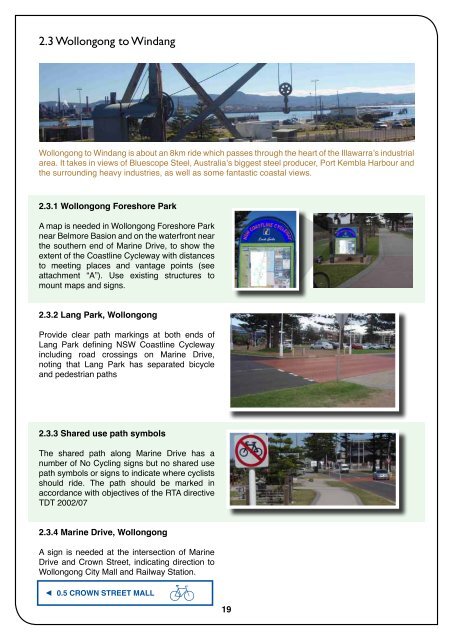
2.3 Wollongong to Windang<br />
Wollongong to Windang is about an 8km ride which passes through the heart of the <strong>Illawarra</strong>’s industrial<br />
area. It takes in views of Bluescope Steel, Australia’s biggest steel producer, Port Kembla Harbour and<br />
the surrounding heavy industries, as well as some fantastic coastal views.<br />
2.3.1 Wollongong Foreshore Park<br />
A map is needed in Wollongong Foreshore Park<br />
near Belmore Basion and on the waterfront near<br />
the southern end of Marine Drive, to show the<br />
extent of the <strong>Coastline</strong> <strong>Cycleway</strong> with distances<br />
to meeting places and vantage points (see<br />
attachment “A”). Use existing structures to<br />
mount maps and signs.<br />
2.3.2 Lang Park, Wollongong<br />
Provide clear path markings at both ends of<br />
Lang Park defining <strong>NSW</strong> <strong>Coastline</strong> <strong>Cycleway</strong><br />
including road crossings on Marine Drive,<br />
noting that Lang Park has separated bicycle<br />
and pedestrian paths<br />
2.3.3 Shared use path symbols<br />
The shared path along Marine Drive has a<br />
number of No Cycling signs but no shared use<br />
path symbols or signs to indicate where cyclists<br />
should ride. The path should be marked in<br />
accordance with objectives of the RTA directive<br />
TDT 2002/07<br />
2.3.4 Marine Drive, Wollongong<br />
A sign is needed at the intersection of Marine<br />
Drive and Crown Street, indicating direction to<br />
Wollongong City Mall and Railway Station.<br />
0.5 crown street mall<br />
19