

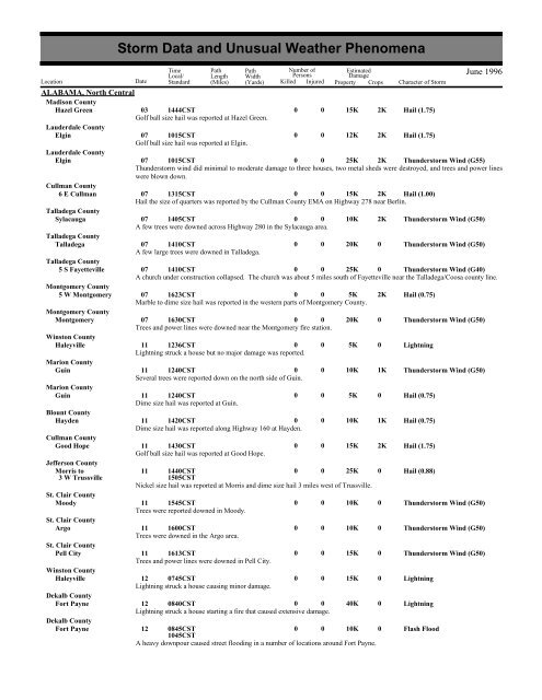
Storm Data and Unusual Weather Phenomena - CIG
Storm Data and Unusual Weather Phenomena - CIG
Storm Data and Unusual Weather Phenomena - CIG

You also want an ePaper? Increase the reach of your titles
YUMPU automatically turns print PDFs into web optimized ePapers that Google loves.
<strong>Storm</strong> <strong>Data</strong> <strong>and</strong> <strong>Unusual</strong> <strong>Weather</strong> <strong>Phenomena</strong><br />
Time Path Path<br />
Number of<br />
Estimated<br />
Local/ Length Width<br />
Persons<br />
Damage<br />
Location Date St<strong>and</strong>ard (Miles) (Yards) Killed Injured Property Crops Character of <strong>Storm</strong><br />
June 1996<br />
ALABAMA, North Central<br />
Madison County<br />
Hazel Green 03 1444CST<br />
0 0 15K 2K Hail (1.75)<br />
Golf ball size hail was reported at Hazel Green.<br />
Lauderdale County<br />
Elgin 07 1015CST<br />
0 0 12K 2K Hail (1.75)<br />
Golf ball size hail was reported at Elgin.<br />
Lauderdale County<br />
Elgin 07 1015CST<br />
0 0 25K 2K Thunderstorm Wind (G55)<br />
Thunderstorm wind did minimal to moderate damage to three houses, two metal sheds were destroyed, <strong>and</strong> trees <strong>and</strong> power lines<br />
were blown down.<br />
Cullman County<br />
6 E Cullman 07 1315CST<br />
0 0 15K 2K Hail (1.00)<br />
Hail the size of quarters was reported by the Cullman County EMA on Highway 278 near Berlin.<br />
Talladega County<br />
Sylacauga 07 1405CST<br />
0 0 10K 2K Thunderstorm Wind (G50)<br />
A few trees were downed across Highway 280 in the Sylacauga area.<br />
Talladega County<br />
Talladega 07 1410CST<br />
0 0 20K 0 Thunderstorm Wind (G50)<br />
A few large trees were downed in Talladega.<br />
Talladega County<br />
5 S Fayetteville 07 1410CST<br />
0 0 25K 0 Thunderstorm Wind (G40)<br />
A church under construction collapsed. The church was about 5 miles south of Fayetteville near the Talladega/Coosa county line.<br />
Montgomery County<br />
5 W Montgomery 07 1623CST<br />
0 0 5K 2K Hail (0.75)<br />
Marble to dime size hail was reported in the western parts of Montgomery County.<br />
Montgomery County<br />
Montgomery 07 1630CST<br />
0 0 20K 0 Thunderstorm Wind (G50)<br />
Trees <strong>and</strong> power lines were downed near the Montgomery fire station.<br />
Winston County<br />
Haleyville 11 1236CST<br />
0 0 5K 0 Lightning<br />
Lightning struck a house but no major damage was reported.<br />
Marion County<br />
Guin 11 1240CST<br />
0 0 10K 1K Thunderstorm Wind (G50)<br />
Several trees were reported down on the north side of Guin.<br />
Marion County<br />
Guin 11 1240CST<br />
0 0 5K 0 Hail (0.75)<br />
Dime size hail was reported at Guin.<br />
Blount County<br />
Hayden 11 1420CST<br />
0 0 10K 1K Hail (0.75)<br />
Dime size hail was reported along Highway 160 at Hayden.<br />
Cullman County<br />
Good Hope 11 1430CST<br />
0 0 15K 2K Hail (1.75)<br />
Golf ball size hail was reported at Good Hope.<br />
Jefferson County<br />
Morris to<br />
3 W Trussville<br />
11 1440CST<br />
1505CST<br />
0 0 25K 0 Hail (0.88)<br />
Nickel size hail was reported at Morris <strong>and</strong> dime size hail 3 miles west of Trussville.<br />
St. Clair County<br />
Moody 11 1545CST<br />
0 0 10K 0 Thunderstorm Wind (G50)<br />
Trees were reported downed in Moody.<br />
St. Clair County<br />
Argo 11 1600CST<br />
0 0 10K 0 Thunderstorm Wind (G50)<br />
Trees were downed in the Argo area.<br />
St. Clair County<br />
Pell City 11 1613CST<br />
0 0 15K 0 Thunderstorm Wind (G50)<br />
Trees <strong>and</strong> power lines were downed in Pell City.<br />
Winston County<br />
Haleyville 12 0745CST<br />
0 0 15K 0 Lightning<br />
Lightning struck a house causing minor damage.<br />
Dekalb County<br />
Fort Payne 12 0840CST<br />
0 0 40K 0 Lightning<br />
Lightning struck a house starting a fire that caused extensive damage.<br />
Dekalb County<br />
Fort Payne 12 0845CST<br />
1045CST<br />
0 0 10K 0 Flash Flood<br />
A heavy downpour caused street flooding in a number of locations around Fort Payne.
<strong>Storm</strong> <strong>Data</strong> <strong>and</strong> <strong>Unusual</strong> <strong>Weather</strong> <strong>Phenomena</strong><br />
Time Path Path<br />
Number of<br />
Estimated<br />
Local/ Length Width<br />
Persons<br />
Damage<br />
Location Date St<strong>and</strong>ard (Miles) (Yards) Killed Injured Property Crops Character of <strong>Storm</strong><br />
June 1996<br />
ALABAMA, North Central<br />
Winston County<br />
Haleyville 13 0650CST<br />
0 0 30K 0 Lightning<br />
Lightning struck a house causing damage to at least half of the house.<br />
Elmore County<br />
2 NE Wetumpka 13 1745CST<br />
0 0 10K 1K Hail (0.75)<br />
A storm spotter reported three-quarter inch hail just northeast of Wetumpka.<br />
Dallas County<br />
Selma 13 1800CST<br />
0 0 15K 0 Lightning<br />
Lightning struck the E-911 communications system knocking it off the air for about 15 minutes.<br />
Russell County<br />
Phenix City 15 1700CST<br />
0 0 10K 0 Hail (0.75)<br />
Hail ranging from marble to dime size was reported at Phenix City.<br />
Russell County<br />
Seale 15 1725CST<br />
0 0 20K 2K Thunderstorm Wind (G50)<br />
Several trees were downed near the fire department <strong>and</strong> the post office in Seale. Several power lines were also downed.<br />
Jefferson County<br />
Birmingport 19 1400CST<br />
1500CST<br />
0 0 10K 0 Flash Flood<br />
Heavy rain created localized flooding including the flooding of some streets in the Birmingport area.<br />
Winston County<br />
Natural Bridge 20 1545CST<br />
0 0 20K 0 Thunderstorm Wind (G50)<br />
A roof of a mobile home came apart <strong>and</strong> a fireworks st<strong>and</strong> was damaged.<br />
Lee County<br />
14 NW Phenix City 20 1600CST<br />
0 0 25K 0 Thunderstorm Wind (G50)<br />
A few trees were downed <strong>and</strong> a boat house was damaged at Lake Harding.<br />
Lee County<br />
Smiths 23 1138CST<br />
0 0 10K 0 Hail (0.75)<br />
Three-quarter inch hail was reported at Smiths in southeast Lee County.<br />
Lee County<br />
Auburn 23 1318CST<br />
0 0 15K 0 Lightning<br />
Lightning struck a house causing damage that was described as light.<br />
Lee County<br />
Auburn 23 1348CST<br />
0 0 15K 0 Lightning<br />
Lightning struck a tree next to a house. The tree fell onto the chimney <strong>and</strong> caught the roof on fire. Damage was reported as minor.<br />
Lauderdale County<br />
Florence 23 1400CST<br />
0 0 35K 0 Lightning<br />
Lightning struck a house causing considerable damage.<br />
Lauderdale County<br />
Florence 23 1400CST<br />
1500CST<br />
0 0 10K 0 Flash Flood<br />
Heavy rain caused street flooding. A woman was trapped inside her car when water started rising <strong>and</strong> the car stalled.<br />
Walker County<br />
Carbon Hill 23 1523CST<br />
0 0 10K 2K Thunderstorm Wind (G50)<br />
Thunderstorm wind downed several trees in the Carbon Hill area.<br />
Tuscaloosa County<br />
Samantha 23 1615CST<br />
0 0 8K 2K Hail (0.75)<br />
Dime size hail was reported at Samantha.<br />
Tuscaloosa County<br />
Samantha 23 1615CST<br />
0 0 18K 0 Thunderstorm Wind (G50)<br />
A roof on a house was damaged <strong>and</strong> several trees were downed in the Samantha area.<br />
Madison County<br />
Gurley 23 1955CST<br />
0 0 20K 0 Lightning<br />
Lightning struck a power station causing approximately 4800 homes to lose power.<br />
Chilton County<br />
6 NE Maplesville 27 1840CST<br />
0 0 10K 2K Thunderstorm Wind (G50)<br />
Trees were reported downed between Jemison <strong>and</strong> Maplesville.<br />
Bibb County<br />
Lawley 27 1845CST<br />
0 0 10K 0 Thunderstorm Wind (G50)<br />
Numerous trees were reported downed across Highway 82 at Lawley.<br />
ALABAMA, Southeast<br />
Coffee County<br />
Enterprise 26 1430CST<br />
1 2 0 0 Lightning<br />
Three children playing on an unfinished soccer field next to a YMCA were struck by lightning. One child was fatally injured while<br />
the 2 other children received only minor injuries. M10BF
ALABAMA, Southwest<br />
Crenshaw County<br />
Luverne<br />
Choctaw County<br />
Womack Hill<br />
Conecuh County<br />
Lyeffion<br />
Baldwin County<br />
Orange Beach<br />
ALASKA, Northern<br />
<strong>Storm</strong> <strong>Data</strong> <strong>and</strong> <strong>Unusual</strong> <strong>Weather</strong> <strong>Phenomena</strong><br />
Time Path Path<br />
Number of<br />
Estimated<br />
Local/ Length Width<br />
Persons<br />
Damage<br />
Location Date St<strong>and</strong>ard (Miles) (Yards) Killed Injured Property Crops Character of <strong>Storm</strong><br />
07 1700CST<br />
0 0 1K<br />
SEVERAL TREES AND POWER LINES WERE BLOW DOWN NEAR LUVERNE.<br />
June 1996<br />
Thunderstorm Wind (G50)<br />
07 1730CST<br />
0 0 1.5K<br />
Thunderstorm Wind (G50)<br />
SEVERAL TREES AND POWER LINES WERE BLOWN DOWN ALONG COUNTY ROAD 25 NEAR WOMACK HILL.<br />
13 1630CST<br />
0 0 1.5K<br />
Thunderstorm Wind (G50)<br />
TREES AND POWER LINES WERE BLOWN DOWN ALONG COUNTY ROAD 30 NEAR LYEFFION.<br />
15 1120CST<br />
0 0<br />
Waterspout<br />
A WATERSPOUT WAS REPORTED NEAR ORANGE BEACH JUST OFFSHORE OF SEVERAL CONDOMINIUMS. NO<br />
DAMAGE WAS REPOPRTED.<br />
ALASKA, Southeast<br />
AKZ015<br />
ALASKA, Southern<br />
AKZ019<br />
AKZ011<br />
Ck Inlt Susitna(C) /<br />
Homer(C)<br />
Big Lake<br />
AKZ023<br />
AKZ021<br />
AKZ019<br />
Ck Inlt Susitna(C) /<br />
Homer(C)<br />
Tustumena Lk<br />
AKZ010<br />
AKZ011-021<br />
NONE REPORTED.<br />
Coastal Southeast Alaska<br />
29 2100AST<br />
0 0<br />
High Wind (G61)<br />
30 0900AST<br />
An unseasonably strong low pressure system moved northward along the coastline of Southeast Alaska June 29-30. Saturday<br />
evening (June 29), winds gusted to 61 kt at Hydaberg <strong>and</strong> to 51 kt at Cape Decision. As the low continued northward overnight,<br />
stations in central Southeast Alaska reported gusty winds including 32 kt at Petersberg, 36 kt at Sitka, <strong>and</strong> 49 kt in downtown<br />
Juneau.<br />
Central Gulf Coast<br />
01 0000AST<br />
2359AST<br />
High temperature record 76 set at the Valdez city site.<br />
Bristol Bay Coastal<br />
01 0000AST<br />
2359AST<br />
High temperature record 79 at King Salmon airport.<br />
0<br />
0<br />
0<br />
0<br />
Temperature Record<br />
Temperature Record<br />
02 0000AST<br />
0 0 10M<br />
Wild/Forest Fire<br />
12 0000AST<br />
Apparent fire works touched off one of the most expensive fires to affect the state. On June 2nd, a small fire began. It "blew up"<br />
on Sunday at around 1030 pm as brisk north winds developed (very unusual for this time of year). Gusty north winds turned to the<br />
northeast then southeast during the next several days. The fire burned across 37,330 acres of l<strong>and</strong>...much of it in the Big Lake area<br />
where many recreational homes, cabins <strong>and</strong> businesses are/were located. The fire was named "Miller's Reach", however due to its<br />
proximity to the Lake, quickly became known as the "Big Lake" fire. It was finally contained late on Monday, June 10th...after<br />
causing an estimated 10 million dollars damage to structures.<br />
St. Paul Isl<strong>and</strong><br />
03 0000AST<br />
0 0<br />
Temperature Record<br />
2359AST<br />
High temperature record 54 at Saint Paul.<br />
Western Alaska Peninsula<br />
03 0000AST<br />
0 0<br />
Temperature Record<br />
2359AST<br />
Record high of 59 reported at Cold Bay...beating old record of 58 (1990).<br />
Central Gulf Coast<br />
05 0300AST<br />
0 0<br />
High Wind (G49)<br />
Wind gusts reached 56 mph...which was the highest recorded in the month of June for 20+ years. This broke the previous record<br />
of 38 mph by a "long shot".<br />
07 0000AST<br />
0 0<br />
Wild/Forest Fire<br />
12 0000AST<br />
Another fire of unknown origins, developed near Tustumena Lake on the Kenai Peninsula on June 7. It became known as the<br />
"Crooked Creek" fire...<strong>and</strong>, as of June 12, had burned around 23,000 acres.<br />
Yukon-Kuskokwim Delta<br />
09 0000AST<br />
0 0<br />
High Wind (G35)<br />
2359AST<br />
A weak low moved rapidly southeast through Bristol Bay...causing wind gusts of 40 mph at Cape Romanzof.<br />
Bristol Bay Coastal - Western Alaska Peninsula<br />
10 0000AST<br />
0 0<br />
High Wind (G36)<br />
11 2359AST
ALASKA, Southern<br />
AKZ010<br />
AKZ021<br />
<strong>Storm</strong> <strong>Data</strong> <strong>and</strong> <strong>Unusual</strong> <strong>Weather</strong> <strong>Phenomena</strong><br />
Time Path Path<br />
Number of<br />
Estimated<br />
Local/ Length Width<br />
Persons<br />
Damage<br />
Location Date St<strong>and</strong>ard (Miles) (Yards) Killed Injured Property Crops Character of <strong>Storm</strong><br />
June 1996<br />
A moderate pressure gradient between a ridge in the eastern Aleutians <strong>and</strong> a moderate low just east of Kodiak caused wind gusts of<br />
41 mph at both Cold Bay <strong>and</strong> Cape Newenham.<br />
Yukon-Kuskokwim Delta<br />
12 0000AST<br />
0 0<br />
Temperature Record<br />
2359AST<br />
Record low of 31 at Bethel.<br />
Western Alaska Peninsula<br />
13 0000AST<br />
0 0<br />
Temperature Record<br />
2359AST<br />
Record low of 30 at Cold Bay (tied the entire month of June record low).<br />
AKZ011-021<br />
Bristol Bay Coastal - Western Alaska Peninsula<br />
16<br />
17<br />
0000AST<br />
2359AST<br />
0 0<br />
High Wind (G45)<br />
A moderate 992 mb low curved northward out of the northcentral Pacific to just west of Dutch Harbor early Sunday. The low<br />
curved westward...weakening to a 995mb center 120 miles south of Saint Paul Isl<strong>and</strong> early Monday. At Cold Bay winds reached<br />
45 on Saturday, 52 on Sunday, <strong>and</strong> 46 on Monday. At Port Heiden, wind gusts hit 47 on Sunday <strong>and</strong> 44 on Monday. At Cape<br />
Newenham, wind gusts reached 45 mph on Monday.<br />
AKZ010<br />
Yukon-Kuskokwim Delta<br />
16 0000AST<br />
2359AST<br />
0 0<br />
Temperature Record<br />
Record high at Bethel of 77.<br />
AKZ021<br />
Western Alaska Peninsula<br />
19 0000AST<br />
2359AST<br />
0 0<br />
High Wind (G35)<br />
A weak front moved northeast through the Alaska Peninsula...bringing wind gusts up to 40 mph at Port Heiden.<br />
AKZ011-021>023 Bristol Bay Coastal - Western Alaska Peninsula - Eastern Aleutians - St. Paul Isl<strong>and</strong><br />
22<br />
23<br />
0000AST<br />
2359AST<br />
0 0<br />
High Wind (G56)<br />
A large, deep 970mb low in the central north Pacific moved to Adak late Sunday morning with a moderate front in a southeast arc<br />
through Dutch Harbor. The low then drifted into the extreme south central Bering Sea early Monday. The front elongated north<br />
<strong>and</strong> east...extending in an arc through Saint Lawrence Isl<strong>and</strong> to McGrath then into Kachemak Bay <strong>and</strong> southward at 4am Monday.<br />
The front then moved into the northcentral Alaskan interior <strong>and</strong> central Gulf of Alaska Monday evening...weakening. The parent<br />
low began to weaken 300 miles northwest of Dutch Harbor at 4am Tuesday.<br />
On both Saturday <strong>and</strong> Sunday...winds reached 52 mph in gusts at Shemya.<br />
On Sunday...gusts reached 48 mph at Saint Paul, 60 mph at Cold Bay, 64 mph at Port Heiden <strong>and</strong> 54 mph at Cape Newenham.<br />
On Monday...gusts reached 44 mph at Adak.<br />
W. Ak Peninsula / Cold<br />
Bay<br />
Cold Bay<br />
22 0000AST<br />
2359AST<br />
0 0<br />
Heavy Rain<br />
On June 22nd, the same storm that brought strong winds also drenched Cold Bay with 3.2 inches of rain. This set a new June<br />
precipitation record (2.9 inches occurred from midnight to noon).<br />
The Russel Creek hatchery was alerted as to the Flash Flood threat <strong>and</strong> rose an estimated 8-10 feet above normal. No damage was<br />
reported.<br />
ARIZONA, Central <strong>and</strong> Northeast<br />
Coconino County<br />
50 SE Sedona 03 1605MST<br />
1615MST<br />
0 0<br />
Waterspout<br />
Waterspout on Woods Canyon Lake damaged several boats <strong>and</strong> boat docks.<br />
Coconino County<br />
Countywide<br />
20<br />
30<br />
1200MST<br />
2359MST<br />
0 0<br />
Wild/Forest Fire<br />
Wildfire outbreak. Two days of numerous dry thunderstorms, June 20 <strong>and</strong> 21, started over 120 lightning-caused fires. By the end<br />
of June, over 82,000 acres of private <strong>and</strong> public l<strong>and</strong> was burned. Most were controlled by June 23, but several burned through the<br />
end of June until July 6 when the first significant rain occurred. The most significant wildfires were:<br />
BRIDGER KNOLLS/JUMP Fire: started at 1700, 06/20, controlled 07/06. Acres burned by end of June: 53,500, on the Northern<br />
Rim of the Gr<strong>and</strong> Canyon.<br />
HOCHDERFFER FIRE: started 06/20, controlled 07/03. Total acres burned: 16,400. Twelve miles NW of Flagstaff.<br />
POT FIRE: started 06/20, controlled 06/26. Total acres burned: 7000. Ten miles NE of Sedona.<br />
COTTONWOOD FIRE: started 06/20, controlled 06/25. One mile south of Pinedale. Total acres burned: 1586.<br />
Gila County<br />
Countywide<br />
20<br />
30<br />
1200MST<br />
2359MST<br />
0 0<br />
Wild/Forest Fire<br />
Wildfire outbreak described in Coconino County entry.<br />
Navajo County<br />
Countywide<br />
20<br />
30<br />
1200MST<br />
2359MST<br />
0 0<br />
Wild/Forest Fire
<strong>Storm</strong> <strong>Data</strong> <strong>and</strong> <strong>Unusual</strong> <strong>Weather</strong> <strong>Phenomena</strong><br />
Time Path Path<br />
Number of<br />
Estimated<br />
Local/ Length Width<br />
Persons<br />
Damage<br />
Location Date St<strong>and</strong>ard (Miles) (Yards) Killed Injured Property Crops Character of <strong>Storm</strong><br />
ARIZONA, Central <strong>and</strong> Northeast<br />
Wildfire outbreak described in Coconino County entry.<br />
Yavapai County<br />
Countywide<br />
20<br />
30<br />
1200MST<br />
2359MST<br />
0<br />
Wildfire outbreak described in Coconino County entry.<br />
Apache County<br />
Countywide<br />
20<br />
30<br />
1200MST<br />
2359MST<br />
0<br />
Wildfire outbreak described in Coconino County entry.<br />
Apache County<br />
.5 NW St Johns 21 1657MST<br />
1658MST<br />
0<br />
Thunderstorm wind gust to 70 mph/61 kts at St. Johns Airport.<br />
0<br />
0<br />
0<br />
Wild/Forest Fire<br />
Wild/Forest Fire<br />
June 1996<br />
Thunderstorm Wind (G61)<br />
Yavapai County<br />
Prescott<br />
Gila County<br />
26 1215MST<br />
0 0<br />
Thunderstorm Wind (G40)<br />
Thunderstorm wind gust to 40 kts snapped a power pole. The pole fell on a mobile home causing a fire. The mobile home was<br />
extensively damaged by the pole <strong>and</strong> the fire.<br />
30 1500MST<br />
Large dust devil destroyed an aluminum shed.<br />
0<br />
0<br />
Dust Devil<br />
ARIZONA, Northwest<br />
NONE REPORTED.<br />
ARIZONA, South<br />
AZZ023<br />
Tucson Metro/Santa Cruz Valley<br />
10 2050MST<br />
2100MST<br />
0 0 15K<br />
Dust Devil<br />
Half of a roof was blown off a house in Tucson near River <strong>and</strong> Campbell streets. No thunderstorms in area so most likely cause<br />
was a very strong dust devil.<br />
Santa Cruz County<br />
3 S Tucson 26 1700MST<br />
1710MST<br />
0 2<br />
Lightning<br />
Two people struck by lightning 3 miles south of Tucson International Airport. Minor injuires, no deaths.<br />
Santa Cruz County<br />
Thatcher/Safford 29 1520MST<br />
1540MST<br />
0 0 320K 10K Thunderstorm Wind (G80)<br />
A strong thunderstorm downbusrt in Thatcher <strong>and</strong> Safford created the following damage. Crop damage, trees down <strong>and</strong> broken,<br />
power lines down, roof damage, one mobile home blown off its blocks, one mobile home flipped over, small signs <strong>and</strong> awnings<br />
blown away, billboard blown into new cars, flooding of some apartments, <strong>and</strong> structure fire caused by lightning. Rainfall was<br />
estimated at 11/2 to 2 inches with hail nearly covering the ground.<br />
Cochise County<br />
8 E (Fhu)Ft Huachuca 29 1900MST<br />
0 0<br />
Lightning<br />
Afb<br />
A hiker in the Huachuca Mountains had a lightning strike hit extremely close to him. He was thrown off his feet <strong>and</strong> could not<br />
move for several seconds. The thunder caused his ears to ring for many days afterward.<br />
ARIZONA, Southwest<br />
NONE REPORTED.<br />
ARKANSAS, Central <strong>and</strong> North Central<br />
Newton County<br />
Ponca<br />
01 0425CST<br />
0<br />
Thunderstorm winds downed some large tree limbs.<br />
Baxter County<br />
Henderson<br />
02 2005CST<br />
0<br />
Several trees were blown down.<br />
Fulton County<br />
Wild Cherry<br />
02 2025CST<br />
0<br />
Thunderstorm winds blew shutters off several buildings.<br />
Fulton County<br />
Wild Cherry<br />
02 2025CST<br />
0<br />
Searcy County<br />
Marshall<br />
02 2037CST<br />
0<br />
Thunderstorm winds blew down several trees.<br />
Izard County<br />
La Crosse<br />
02 2050CST<br />
0<br />
0<br />
0<br />
0<br />
0<br />
0<br />
0<br />
Thunderstorm Wind (G50)<br />
Thunderstorm Wind (G50)<br />
Thunderstorm Wind (G50)<br />
Hail (1.75)<br />
Thunderstorm Wind (G50)<br />
Thunderstorm Wind (G50)
<strong>Storm</strong> <strong>Data</strong> <strong>and</strong> <strong>Unusual</strong> <strong>Weather</strong> <strong>Phenomena</strong><br />
Time Path Path<br />
Number of<br />
Estimated<br />
Local/ Length Width<br />
Persons<br />
Damage<br />
Location Date St<strong>and</strong>ard (Miles) (Yards) Killed Injured Property Crops Character of <strong>Storm</strong><br />
June 1996<br />
ARKANSAS, Central <strong>and</strong> North Central<br />
Some power lines were blown down.<br />
Izard County<br />
Jumbo<br />
02 2055CST<br />
0 0<br />
Thunderstorm Wind (G50)<br />
Thunderstorm winds downed several power lines.<br />
Clark County<br />
2 NW Curtis 03 1351CST<br />
0 0<br />
Hail (0.88)<br />
Pope County<br />
Dover<br />
03 1407CST<br />
0 0<br />
Hail (1.75)<br />
White County<br />
Bald Knob<br />
03 1450CST<br />
1455CST<br />
0 0<br />
Hail (0.75)<br />
Hail up to dime size covered the ground at Bald Knob.<br />
White County<br />
Bald Knob<br />
03 1535CST<br />
0 0<br />
Hail (1.00)<br />
Faulkner County<br />
Greenbrier<br />
03 1700CST<br />
0 0<br />
Hail (0.75)<br />
White County<br />
Floyd<br />
03 1715CST<br />
0 0<br />
Thunderstorm Wind (G50)<br />
Thunderstorm winds knocked down a few power poles.<br />
Perry County<br />
Perry<br />
03 1720CST<br />
1725CST<br />
0 0<br />
Hail (1.00)<br />
Hail up to quarter size damaged several vehicles in Perry.<br />
Jefferson County<br />
Altheimer<br />
03 1730CST<br />
0 0<br />
Hail (0.75)<br />
White County<br />
Antioch<br />
03 1730CST<br />
0 0<br />
Thunderstorm Wind (G50)<br />
Thunderstorm winds downed several trees.<br />
Yell County<br />
Dardanelle<br />
04 1845CST<br />
0 0<br />
Hail (1.00)<br />
Yell County<br />
Dardanelle<br />
04 1845CST<br />
0 0<br />
Thunderstorm Wind (G50)<br />
Thunderstorm winds downed some trees <strong>and</strong> power lines.<br />
Pope County<br />
1 SW Russellville 04 1850CST<br />
0 0<br />
Hail (1.00)<br />
Pope County<br />
Russellville<br />
04 1855CST<br />
0 0<br />
Hail (1.00)<br />
Marion County<br />
Oakl<strong>and</strong><br />
06 1415CST<br />
0 0<br />
Hail (0.75)<br />
Boone County<br />
Gaither<br />
06 1430CST<br />
0 0<br />
Hail (0.75)<br />
Boone County<br />
Gaither<br />
06 1430CST<br />
0 0<br />
Thunderstorm Wind (G50)<br />
Thunderstorm winds knocked down some trees.<br />
Newton County<br />
Ponca<br />
06 1445CST<br />
0 0<br />
Thunderstorm Wind (G50)<br />
Thunderstorm winds downed some large tree limbs.<br />
Baxter County<br />
Mountain Home<br />
06 1450CST<br />
0 0<br />
Thunderstorm Wind (G50)<br />
Several trees were blown down.<br />
Marion County<br />
5 N Pyatt 06 1500CST<br />
0 0<br />
Thunderstorm Wind (G50)<br />
Thunderstorm winds blew down a few trees.<br />
Newton County<br />
Deer<br />
06 1515CST<br />
0 0<br />
Thunderstorm Wind (G50)<br />
Thunderstorm winds downed some large tree limbs.<br />
Newton County<br />
Lurton<br />
06 1525CST<br />
0 0<br />
Thunderstorm Wind (G50)<br />
Several large tree limbs were blown down.<br />
Baxter County<br />
Mountain Home<br />
06 1525CST<br />
0 1<br />
Lightning<br />
A youth was struck by lightning while riding a 4-wheeler near Mountain Home. He was taken to a local hospital for treatment.<br />
Searcy County<br />
Leslie<br />
06 1530CST<br />
0 0<br />
Hail (0.75)<br />
Baxter County<br />
Norfork<br />
06 1535CST<br />
0 0<br />
Hail (1.00)
<strong>Storm</strong> <strong>Data</strong> <strong>and</strong> <strong>Unusual</strong> <strong>Weather</strong> <strong>Phenomena</strong><br />
Time Path Path<br />
Number of<br />
Estimated<br />
Local/ Length Width<br />
Persons<br />
Damage<br />
Location Date St<strong>and</strong>ard (Miles) (Yards) Killed Injured Property Crops Character of <strong>Storm</strong><br />
June 1996<br />
ARKANSAS, Central <strong>and</strong> North Central<br />
Van Buren County<br />
Botkinburg<br />
06 1600CST<br />
0 0<br />
Hail (0.75)<br />
Stone County<br />
3 N Fifty Six 06 1600CST<br />
1605CST<br />
0 0<br />
Hail (1.25)<br />
Hail up to half-dollar size damaged a vehicle.<br />
Izard County<br />
Oxford<br />
06 1605CST<br />
0 0<br />
Hail (0.75)<br />
Pope County<br />
Pelsor<br />
06 1620CST<br />
0 0<br />
Thunderstorm Wind (G50)<br />
Thunderstorm winds downed a large tree.<br />
Sharp County<br />
Calamine<br />
06 1645CST<br />
0 0<br />
Thunderstorm Wind (G50)<br />
Thunderstorm winds blew down several trees.<br />
Conway County<br />
Center Ridge<br />
06 1700CST<br />
0 0<br />
Hail (0.75)<br />
Cleburne County<br />
Heber Spgs<br />
06 1730CST<br />
0 1<br />
Lightning<br />
A man was struck by lightning while st<strong>and</strong>ing in the doorway of a barn during a thunderstorm. He suffered minor injuries <strong>and</strong> was<br />
taken to a local hospital for treatment.<br />
Perry County<br />
Adona<br />
06 1920CST<br />
0 0<br />
Hail (0.75)<br />
Polk County<br />
Hatfield<br />
06 2038CST<br />
0 0<br />
Hail (1.00)<br />
Polk County<br />
Acorn<br />
06 2042CST<br />
0 0<br />
Hail (0.75)<br />
Pike County<br />
Glenwood<br />
06 2200CST<br />
0 0<br />
Thunderstorm Wind (G50)<br />
Thunderstorm winds blew down a number of trees.<br />
Montgomery County<br />
Welsh<br />
06 2215CST<br />
0 0<br />
Thunderstorm Wind (G50)<br />
Thunderstorm winds downed some trees.<br />
Hot Spring County<br />
Bismarck<br />
06 2250CST<br />
0 0<br />
Thunderstorm Wind (G56)<br />
Thunderstorm winds up to 65 mph blew down some trees.<br />
Hot Spring County<br />
Donaldson<br />
06 2258CST<br />
0 0<br />
Thunderstorm Wind (G52)<br />
Thunderstorm winds gusted to 60 mph at Donaldson <strong>and</strong> tore part of the roof off a school building.<br />
Hot Spring County<br />
Malvern<br />
06 2305CST<br />
0 0<br />
Thunderstorm Wind (G50)<br />
Several trees were blown down.<br />
Garl<strong>and</strong> County<br />
3 W Lonsdale 06 2310CST<br />
0 0<br />
Thunderstorm Wind (G50)<br />
Thunderstorm winds blew down some trees.<br />
Hot Spring County<br />
Marcus<br />
06 2315CST<br />
0 0<br />
Thunderstorm Wind (G50)<br />
Thunderstorm winds knocked down some trees on the northern end of DeGray Lake.<br />
Grant County<br />
Tull<br />
06 2315CST<br />
2318CST<br />
0 0<br />
Hail (1.75)<br />
Grant County<br />
Tull<br />
06 2315CST<br />
0 0<br />
Thunderstorm Wind (G50)<br />
Thunderstorm winds blew down some large trees.<br />
Jefferson County<br />
Pine Bluff<br />
07 0000CST<br />
0 0<br />
Thunderstorm Wind (G50)<br />
Thunderstorm winds knocked down numerous trees in the western parts of Pine Bluff.<br />
Arkansas County<br />
De Witt<br />
07 0115CST<br />
0 0<br />
Thunderstorm Wind (G50)<br />
A few trees were blown down by thunderstorm winds.<br />
Lonoke County<br />
Engl<strong>and</strong><br />
07 1838CST<br />
0 0<br />
Hail (0.75)<br />
Arkansas County<br />
5 NW Lodge Corner 07 1955CST<br />
0 0<br />
Hail (0.75)<br />
Monroe County<br />
1 SW Brinkley 07 2015CST<br />
0 0<br />
Hail (0.88)
<strong>Storm</strong> <strong>Data</strong> <strong>and</strong> <strong>Unusual</strong> <strong>Weather</strong> <strong>Phenomena</strong><br />
Time Path Path<br />
Number of<br />
Estimated<br />
Local/ Length Width<br />
Persons<br />
Damage<br />
Location Date St<strong>and</strong>ard (Miles) (Yards) Killed Injured Property Crops Character of <strong>Storm</strong><br />
June 1996<br />
ARKANSAS, Central <strong>and</strong> North Central<br />
Monroe County<br />
Rich<br />
07 2035CST<br />
0 0<br />
Hail (0.75)<br />
Pulaski County<br />
Maumelle<br />
12 1628CST<br />
0 0<br />
Hail (0.75)<br />
Faulkner County<br />
Mayflower<br />
13 0945CST<br />
0 0<br />
Thunderstorm Wind (G39)<br />
Thunderstorm winds gusted to 45 mph <strong>and</strong> overturned a small boat on the southern end of Lake Conway near Mayflower.<br />
Johnson County<br />
5 N Clarksville 17 1500CST<br />
0 0<br />
Thunderstorm Wind (G50)<br />
Thunderstorm winds downed a few trees.<br />
Van Buren County<br />
3.5 E Scotl<strong>and</strong> 17 1615CST<br />
0 0<br />
Thunderstorm Wind (G50)<br />
Thunderstorm winds downed some trees.<br />
Marion County<br />
Bull Shoals<br />
17 1630CST<br />
0 0<br />
Thunderstorm Wind (G50)<br />
Thunderstorm winds downed some trees <strong>and</strong> damaged the roofs of several buildings.<br />
Pulaski County<br />
North Little Rock 18 1840CST<br />
0 0<br />
Hail (0.88)<br />
Clevel<strong>and</strong> County<br />
Rison<br />
18 1845CST<br />
0 0<br />
Thunderstorm Wind (G50)<br />
Thunderstorm winds downed several trees <strong>and</strong> power lines.<br />
Marion County<br />
Peel<br />
18 1944CST<br />
0 0<br />
Hail (0.75)<br />
Baxter County<br />
Cotter<br />
18 2010CST<br />
0 0<br />
Thunderstorm Wind (G50)<br />
Thunderstorm winds downed trees <strong>and</strong> power lines.<br />
Baxter County<br />
Gassville<br />
18 2010CST<br />
0 0<br />
Thunderstorm Wind (G50)<br />
Several trees <strong>and</strong> power lines were knocked down.<br />
Franklin County<br />
6 W Cecil 19 0235CST<br />
0 0<br />
Thunderstorm Wind (G50)<br />
Thunderstorm winds downed some trees.<br />
Lonoke County<br />
2 N Lonoke 19 1245CST<br />
0 0<br />
Thunderstorm Wind (G50)<br />
Thunderstorm winds damaged the roof of a house <strong>and</strong> downed some large tree limbs.<br />
White County<br />
4 S Rose Bud 19 1245CST<br />
0 0<br />
Thunderstorm Wind (G50)<br />
Thunderstorm winds downed a few trees <strong>and</strong> some large tree limbs.<br />
ARKANSAS, East<br />
Craighead County<br />
Black Oak<br />
06 1815CST<br />
1820CST<br />
0 0 0.10K<br />
Thunderstorm Wind<br />
A power pole <strong>and</strong> some small trees were knocked down.<br />
Mississippi County<br />
Gosnell<br />
06 1820CST<br />
1825CST<br />
0 0 5K<br />
Thunderstorm Wind<br />
A roof was blown off of a mobile home.<br />
ARKANSAS, Northwest<br />
Washington County<br />
Lincoln<br />
01 0320CST<br />
0 0 0.10K<br />
Thunderstorm Wind<br />
Washington County<br />
Fayetteville<br />
01 0320CST<br />
0 0 0.10K<br />
Thunderstorm Wind<br />
A severe thunderstorm produced strong winds which downed trees in Lincoln <strong>and</strong> in Fayetteville.<br />
Carroll County<br />
3 WNW Eureka Spgs 02 2100CST<br />
0 0<br />
Hail (0.75)<br />
Benton County<br />
Gravette<br />
02 2258CST<br />
0 0<br />
Hail (0.75)<br />
Isolated severe thunderstorms developed in extreme northwest Arkansas during the evening of June 2nd. Dime size hail fell 3<br />
miles west northwest of Eureka Springs <strong>and</strong> at Gravette.<br />
Crawford County<br />
Chester<br />
03 0310CST<br />
0 0<br />
Hail (0.75)<br />
A severe thunderstorm produced dime size hail at Chester.<br />
Washington County<br />
Elkins<br />
06 1400CST<br />
0 0<br />
Hail (0.75)<br />
Carroll County<br />
8 S Green Forest 06 1401CST<br />
0 0<br />
Hail (1.00)
<strong>Storm</strong> <strong>Data</strong> <strong>and</strong> <strong>Unusual</strong> <strong>Weather</strong> <strong>Phenomena</strong><br />
Time Path Path<br />
Number of<br />
Estimated<br />
Local/ Length Width<br />
Persons<br />
Damage<br />
Location Date St<strong>and</strong>ard (Miles) (Yards) Killed Injured Property Crops Character of <strong>Storm</strong><br />
ARKANSAS, Northwest<br />
Madison County<br />
2 S Huntsville 06 1415CST<br />
0 0<br />
Hail (0.75)<br />
Madison County<br />
5 E St Paul 06 1445CST<br />
0 0<br />
Hail (0.75)<br />
Severe thunderstorms developed in northwest Arkansas during the afternoon of June 6th. Quarter size hail fell 8 miles south of<br />
Green Forest, <strong>and</strong> dime size hail fell at Elkins, 2 miles south of Huntsville, <strong>and</strong> 5 miles east of St. Paul.<br />
Madison County<br />
Huntsville<br />
18 2220CST<br />
0 0 0.10K<br />
Thunderstorm Wind<br />
A severe thunderstorm produced strong winds which downed numerous large tree limbs in Huntsville.<br />
Sebastian County<br />
Ft Smith<br />
19 0201CST<br />
0 0<br />
Thunderstorm Wind (G56)<br />
Sebastian County<br />
4 SE Ft Smith 19 0204CST<br />
0 0<br />
Thunderstorm Wind (G58)<br />
Sebastian County<br />
Barling<br />
19 0205CST<br />
0 0 0.10K<br />
Thunderstorm Wind<br />
Sebastian County<br />
Greenwood<br />
19 0210CST<br />
0 0 0.10K<br />
Thunderstorm Wind<br />
Crawford County<br />
Van Buren<br />
19 0215CST<br />
0 0 15K<br />
Thunderstorm Wind<br />
Sebastian County<br />
1 N Lavaca 19 0220CST<br />
0 0 0.10K<br />
Thunderstorm Wind<br />
Crawford County<br />
Alma<br />
19 0220CST<br />
0 0 5K<br />
Thunderstorm Wind<br />
Sebastian County<br />
Bloomer<br />
19 0225CST<br />
0 0 0.10K<br />
Thunderstorm Wind<br />
Severe thunderstorms moved across northwest Arkansas during the early morning of June 19th. Strong thunderstorm winds blew a<br />
truck off the road at the intersection of Interstate 40 <strong>and</strong> Interstate 540 in Van Buren, <strong>and</strong> the strong winds also damaged roofs <strong>and</strong><br />
downed power lines in Van Buren. Strong thunderstorm winds in Alma blew the roof off a pizza place, damaged the roof of a<br />
home, <strong>and</strong> downed trees. Trees were also blown down in Barling, 1 mile north of Lavaca, <strong>and</strong> along State Highway 22 near<br />
Bloomer, <strong>and</strong> large tree limbs were blown down in Greenwood. Thunderstorm winds gusted to 67 miles an hour at the Fort Smith<br />
Municipal Airport 4 miles southeast of Fort Smith <strong>and</strong> to 65 miles an hour in Fort Smith.<br />
ARKANSAS, Southeast<br />
Chicot County<br />
Lake Vlg<br />
18 1445CST<br />
0 0<br />
Hail (0.75)<br />
Chicot County<br />
Eudora<br />
18 1600CST<br />
1700CST<br />
0 0<br />
Flash Flood<br />
Numerous roads <strong>and</strong> streets were flooded in the county.<br />
ARKANSAS, Southwest<br />
Little River County<br />
Foreman<br />
03 2150CST<br />
0 0<br />
Thunderstorm Wind (G60)<br />
Blown down power lines caused numerous power outages in the city.<br />
Little River County<br />
4 SSE Ashdown to 03 2152CST<br />
0 0<br />
Hail (0.75)<br />
Ashdown<br />
Sevier County<br />
De Queen<br />
03 2152CST<br />
0 0<br />
Thunderstorm Wind (G65)<br />
Trees were blown down across roads inside the city blocking traffic.<br />
Sevier County<br />
Lockesburg<br />
03 2158CST<br />
0 0<br />
Thunderstorm Wind (G60)<br />
Numerous trees blown down.<br />
Hempstead County<br />
Hope<br />
04 2210CST<br />
0 0<br />
Thunderstorm Wind (G60)<br />
Numerous trees were blown down across power lines causing numerous power outages in the city.<br />
Hempstead County<br />
Hope<br />
04 2210CST<br />
2330CST<br />
0 0<br />
Flash Flood<br />
Heavy rains in a short period of time resulted in one foot of water across I-30.<br />
Hempstead County<br />
1 NE Fulton to<br />
Fulton<br />
04 2210CST<br />
2330CST<br />
0 0<br />
Flash Flood<br />
Heavy rains resulted in one <strong>and</strong> a half feet of water of I-30 bringing traffic to a halt.<br />
Howard County<br />
Dierks<br />
06 2140CST<br />
0 0<br />
Thunderstorm Wind (G60)<br />
Reported by <strong>Storm</strong> Spotter.<br />
CALIFORNIA, Extreme Southeast<br />
NONE REPORTED.<br />
June 1996
<strong>Storm</strong> <strong>Data</strong> <strong>and</strong> <strong>Unusual</strong> <strong>Weather</strong> <strong>Phenomena</strong><br />
Time Path Path<br />
Number of<br />
Estimated<br />
Local/ Length Width<br />
Persons<br />
Damage<br />
Location Date St<strong>and</strong>ard (Miles) (Yards) Killed Injured Property Crops Character of <strong>Storm</strong><br />
CALIFORNIA, Extreme Southeast<br />
CALIFORNIA, North Central<br />
June 1996<br />
CALIFORNIA, Northeast<br />
NONE REPORTED.<br />
NONE REPORTED.<br />
CALIFORNIA, Northwest<br />
CAZ001<br />
Northwest California<br />
03 0345PST<br />
0 0<br />
Fog<br />
0830PST<br />
Areas of dense coastal fog shrouded much of the Northwest California coast <strong>and</strong> river valleys. Visibilities were reduced to near<br />
zero in Eureka <strong>and</strong> around Humboldt Bay <strong>and</strong> were down to 1/8 mile in Hydesville.<br />
CALIFORNIA, South Central<br />
CALIFORNIA, Southeast<br />
NONE REPORTED.<br />
CALIFORNIA, Southwest<br />
San Diego County<br />
Mission Beach<br />
CALIFORNIA, Upper<br />
NONE REPORTED.<br />
NONE REPORTED.<br />
CALIFORNIA, West South Central<br />
30 1430PST<br />
1 0<br />
Rip Currents<br />
Out of an estimated 295,000 visitors to the San Diego County beaches, 366 rescues were made. Many were blamed on strong rip<br />
currents. One 10-year-old San Diego boy drowned at Mission Beach. M10IW<br />
CALIFORNIA, Western<br />
NONE REPORTED.<br />
NONE REPORTED.<br />
COLORADO, Central <strong>and</strong> Northeast<br />
Larimer County<br />
Fort Collins 04 1700MST<br />
0 1 0 0 Lightning<br />
A heavy equipment operator was struck by lightning as he was climbing off a scraper-grader. He received only minor injuries.<br />
Weld County<br />
Greeley 04 1745MST<br />
0 0 50K 0 Lightning<br />
Lightning strikes damaged a water pump <strong>and</strong> sparked small fires to a storage shed <strong>and</strong> oil tank in Greeley.<br />
Boulder County<br />
Niwot<br />
05 1745MST<br />
1815MST<br />
0 0<br />
Dry Microburst<br />
Boulder County<br />
Longmont<br />
05 1800MST<br />
1805MST<br />
0 0<br />
Dry Microburst<br />
Boulder County<br />
Boulder<br />
05 1801MST<br />
1806MST<br />
0 0<br />
Dry Microburst<br />
Strong microburst winds to 60 mph (52 kts) damaged several trees in Boulder county snapping large branches from 1 to 2 inches in<br />
diameter.<br />
Weld County<br />
La Salle 08 1800MST<br />
0 0 1K 0 Lightning<br />
Lightning destroyed a water pump at the La Salle Waste Water Site.<br />
Weld County<br />
Keenesburg<br />
09 1415MST<br />
1420MST<br />
0 0<br />
Dry Microburst<br />
Lincoln County<br />
Limon<br />
09 1535MST<br />
1540MST<br />
0 0<br />
Thunderstorm Wind (G56)<br />
Lincoln County<br />
20 SE Hugo 09 1632MST<br />
1637MST<br />
0 0<br />
Thunderstorm Wind (G52)<br />
Larimer County<br />
Fort Collins 10 1600MST<br />
0 0 10K 0 Lightning<br />
Lightning struck <strong>and</strong> killed a horse used by the Fort Collins Police Department's Mounting Patrol Unit. Another horse nearby was<br />
injured.
<strong>Storm</strong> <strong>Data</strong> <strong>and</strong> <strong>Unusual</strong> <strong>Weather</strong> <strong>Phenomena</strong><br />
Time Path Path<br />
Number of<br />
Estimated<br />
Local/ Length Width<br />
Persons<br />
Damage<br />
Location Date St<strong>and</strong>ard (Miles) (Yards) Killed Injured Property Crops Character of <strong>Storm</strong><br />
June 1996<br />
COLORADO, Central <strong>and</strong> Northeast<br />
Weld County<br />
Keenesburg<br />
10 1617MST<br />
1623MST<br />
0 0<br />
Dry Microburst<br />
Morgan County<br />
Brush 10 1943MST<br />
1944MST<br />
0 0 0 0 Funnel Cloud<br />
Elbert County<br />
8 SE Matheson 11 1538MST<br />
1540MST<br />
0 0<br />
Hail (1.75)<br />
Boulder County<br />
Niwot 12 1603MST<br />
0 0<br />
0 Lightning<br />
Lightning struck a power line which caused a temporary outage for 50 residents in the town of Niwot.<br />
Larimer County<br />
9 SW Rustic 12 1630MST<br />
1645MST<br />
0 0<br />
Hail (1.75)<br />
Douglas County<br />
Parker 12 1730MST<br />
0 0<br />
0 Lightning<br />
Lightning struck a house in Parker which sparked a fire. The bolt was strong enough to blow nails out of the dry wall in one room.<br />
Approximately 85 percent of the home was damaged but no dollar estimate of the damage was available.<br />
Boulder County<br />
Boulder 12 1823MST<br />
0 0<br />
0 Lightning<br />
Lightning struck a power line in Boulder which left 250 customers without electricity for a short time.<br />
Morgan County<br />
20 NW Ft Morgan 12 1910MST<br />
1915MST<br />
0 0<br />
Thunderstorm Wind (G61)<br />
Larimer County<br />
Berthoud<br />
12 2100MST<br />
2105MST<br />
0 0<br />
Thunderstorm Wind<br />
Strong thunderstorm winds downed a large tree in the town of Berthoud. Several tree limbs in the area were also snapped by the<br />
high winds.<br />
Lincoln County<br />
7 NE Karval 13 1800MST<br />
0 0<br />
Hail (1.00)<br />
Larimer County<br />
2 E Estes Park 16 1500MST<br />
0 0<br />
Hail (1.00)<br />
Larimer County<br />
2 S Estes Park 16 1510MST<br />
0 0<br />
0 Hail (0.75)<br />
Boulder County<br />
3 NW Pinecliffe to<br />
1.5 NW Pinecliffe<br />
16 1615MST<br />
1635MST<br />
1.5 300 0 0<br />
Tornado (F1)<br />
A small tornado touched down in the foothills west of Boulder, near Pinecliffe, knocking down 50 to 100 large pine trees. A house<br />
nearby sustained damage when shingles were ripped off the roof. The tornado also picked a 17-ft sailboat <strong>and</strong> attached trailer <strong>and</strong><br />
carried it 25 feet into a nearby tree.<br />
Denver County<br />
Denver Airport (Dia) 16 1723MST<br />
1728MST<br />
0 0 0 0 Thunderstorm Wind (G50)<br />
Weld County<br />
Greeley<br />
17 1930MST<br />
2000MST<br />
0 0 13K<br />
Thunderstorm Wind<br />
Strong thunderstorm winds ripped two thirds of the roof off a paving business in North Greeley. Heavy rainfall followed causing<br />
substancial water damage to two floors inside the building.<br />
Phillips County<br />
4 E Haxtun 17 2245MST<br />
2250MST<br />
0 0<br />
Thunderstorm Wind (G54)<br />
Phillips County<br />
Haxtun<br />
17 2255MST<br />
2300MST<br />
0 0<br />
Thunderstorm Wind (G52)<br />
Strong thunderstorm winds gusting to 60 mph (52 kts) toppled a large tree in the town of Haxtun. Several large branches were also<br />
snapped from trees in the area.<br />
Morgan County<br />
4 W Ft Morgan 20 1754MST<br />
0 0<br />
Hail (1.75)<br />
Morgan County<br />
2 SW Brush 20 1800MST<br />
0 0<br />
Hail (1.50)<br />
Weld County<br />
6 SW Stoneham 20 1805MST<br />
0 0<br />
Hail (2.50)<br />
Morgan County<br />
22 NW Ft Morgan 20 1937MST<br />
1942MST<br />
0 0<br />
Thunderstorm Wind (G52)<br />
Morgan County<br />
15 N Ft Morgan 20 1939MST<br />
0 0<br />
Hail (1.50)
<strong>Storm</strong> <strong>Data</strong> <strong>and</strong> <strong>Unusual</strong> <strong>Weather</strong> <strong>Phenomena</strong><br />
Time Path Path<br />
Number of<br />
Estimated<br />
Local/ Length Width<br />
Persons<br />
Damage<br />
Location Date St<strong>and</strong>ard (Miles) (Yards) Killed Injured Property Crops Character of <strong>Storm</strong><br />
June 1996<br />
COLORADO, Central <strong>and</strong> Northeast<br />
Morgan County<br />
12 N Ft Morgan 20 1941MST<br />
1951MST<br />
0 0<br />
Hail (2.00)<br />
Morgan County<br />
22 NW Ft Morgan 20 1942MST<br />
0 0<br />
Hail (1.00)<br />
Weld County<br />
Stoneham<br />
20 2003MST<br />
0 0<br />
Hail (1.75)<br />
Morgan County<br />
8 SE Raymer 20 2010MST<br />
2011MST<br />
0 0 0 0 Funnel Cloud<br />
Logan County<br />
19 SW Sterling 20 2014MST<br />
0 0<br />
Hail (0.75)<br />
Logan County<br />
Peetz 20 2025MST<br />
2026MST<br />
0 0 0 0 Funnel Cloud<br />
Logan County<br />
Merino 20 2029MST<br />
2030MST<br />
0 0 0 0 Funnel Cloud<br />
Morgan County<br />
Fort Morgan<br />
20 2030MST<br />
0 0<br />
Lightning<br />
Lightning set fire to a pile of hay. Since the hay was wet the fire did little damage.<br />
Morgan County<br />
20 NW Ft Morgan 20 2032MST<br />
0 0<br />
Hail (0.75)<br />
Morgan County<br />
Ft Morgan<br />
20 2045MST<br />
2055MST<br />
0 0<br />
Thunderstorm Wind (G50)<br />
Large hail ranging from 3/4 to 1 3/4 inches in diameter, driven by winds as strong as 60 mph (52 kts), caused substancial damage<br />
to corn <strong>and</strong> wheat crops in the Morgan County area. The damage occurred during the late afternoon <strong>and</strong> evening hours of the 20th.<br />
Power lines were also downed leaving 314 customers without electricity. No estimates of the damage were available.<br />
Boulder County<br />
Boulder 20 2145MST<br />
2155MST<br />
0 0<br />
0 Thunderstorm Wind (G61)<br />
Strong thunderstorm winds in Boulder downed several large tree limbs in Boulder at the University of Colorado Campus. A stop<br />
light in the city was also blown down.<br />
Douglas County<br />
Parker 21 1200MST<br />
1322MST<br />
0 0 30K 0 Lightning<br />
Three homes were struck by lightning in Parker, southeast of Denver. Lightning struck the garage of the first home, a small fire<br />
developed which burned some siding <strong>and</strong> spread into the attic. Another home sustained damage in the attic from a small fire while<br />
a third home was hit but received only minor damage. Lightning also sparked two small grassfires in the area.<br />
Jefferson County<br />
Lakewood 21 1200MST<br />
0 1 0 0 Lightning<br />
A man received minor injuries when he was struck by lightning while working on a ladder.<br />
Douglas County<br />
Castle Rock 21 1235MST<br />
1236MST<br />
0 0 0 0 Funnel Cloud<br />
Arapahoe County<br />
15 NE Deer Trail 21 1438MST<br />
1443MST<br />
0 0<br />
Thunderstorm Wind (G52)<br />
Washington County<br />
5 NW Last Chance 21 1451MST<br />
1456MST<br />
0 0<br />
Thunderstorm Wind (G52)<br />
Washington County<br />
Prewitt Reservoir 21 1653MST<br />
1658MST<br />
0 0<br />
Thunderstorm Wind (G61)<br />
Washington County<br />
Last Chance 21 1720MST<br />
1721MST<br />
0 0 0 0 Funnel Cloud<br />
Boulder County<br />
Boulder 21 2045MST<br />
2050MST<br />
0 0<br />
0 Thunderstorm Wind<br />
Strong thunderstorm winds downed a large tree near Crossroads Mall in Boulder.<br />
Adams County<br />
6 E Lafayette 22 1410MST<br />
1415MST<br />
0.1 50 0 0 0 0 Tornado (F0)<br />
Weld County<br />
Greeley 22 2038MST<br />
0 0<br />
0 Lightning<br />
Lightning caused a power outage which left 2500 customers without electricity for about 30 minutes. Areas affected by the outage<br />
included portions of Greeley, Evans, La Salle <strong>and</strong> Gilcrest.
<strong>Storm</strong> <strong>Data</strong> <strong>and</strong> <strong>Unusual</strong> <strong>Weather</strong> <strong>Phenomena</strong><br />
Time Path Path<br />
Number of<br />
Estimated<br />
Local/ Length Width<br />
Persons<br />
Damage<br />
Location Date St<strong>and</strong>ard (Miles) (Yards) Killed Injured Property Crops Character of <strong>Storm</strong><br />
COLORADO, Central <strong>and</strong> Northeast<br />
Washington County<br />
8 SW Akron 24 0405MST<br />
0 0<br />
Hail (1.00)<br />
0500MST<br />
June 1996<br />
Washington County<br />
8 S Akron 24 0600MST<br />
0605MST<br />
0 0 30K 1.2M Hail (2.00)<br />
A nearly stationary thunderstorm spawned a hailstorm that lasted approximately 2 hours south-southwest of Akron. A farmer<br />
reported 1 inch diameter hail had fallen continously for nearly an hour at one point during the event. The area affected by the<br />
storm was approximately 36-sq miles in size. Two farmsteads were completely wiped out <strong>and</strong> others nearby sustained substancial<br />
damage. The hail <strong>and</strong> the flooding that followed resulted in an estimated $1.2 million in damage to crops <strong>and</strong> $30,000 to property.<br />
Weld County<br />
3 NE Hudson 24 1507MST<br />
0 0<br />
Hail (1.75)<br />
Weld County<br />
8 W Roggen 24 1515MST<br />
1516MST<br />
0 0 0 0 Funnel Cloud<br />
Weld County<br />
Hudson 24 1653MST<br />
1654MST<br />
0 0 0 0 Funnel Cloud<br />
Weld County<br />
7 W Roggen 24 1715MST<br />
1716MST<br />
0 0 0 0 Funnel Cloud<br />
Weld County<br />
5 W Roggen 24 1722MST<br />
1723MST<br />
0 0 0 0 Funnel Cloud<br />
Arapahoe County<br />
Littleton 24 1744MST<br />
0 0 1K 0 Lightning<br />
Lightning struck a home in Littleton which sparked a small fire on the roof.<br />
Weld County<br />
2 NW Keenesburg 24 1750MST<br />
1751MST<br />
0 0 0 0 Funnel Cloud<br />
Weld County<br />
3 SW Greeley 24 1900MST<br />
1905MST<br />
0 0<br />
Thunderstorm Wind (G52)<br />
Strong thunderstorm winds to 60 mph (52 kts) downed one large tree <strong>and</strong> snapped large branches off others nearby.<br />
Weld County<br />
Greeley<br />
24 1900MST<br />
1905MST<br />
0 0 50K<br />
Thunderstorm Wind (G52)<br />
Strong thunderstorms winds estimated to 60 mph (52 kts) downed a large tree in Greeley which damaged a nearby home.<br />
Larimer County<br />
Ft Collins<br />
24 1913MST<br />
0 0<br />
Hail (0.75)<br />
Larimer County<br />
1 E Buckhorn Mountain 24 1935MST<br />
0 0<br />
Hail (0.75)<br />
Larimer County<br />
Poudre Park<br />
24 1945MST<br />
0 0<br />
Hail (0.75)<br />
Douglas County<br />
Castle Rock<br />
24 2120MST<br />
2125MST<br />
0 0<br />
Thunderstorm Wind (G56)<br />
Weld County<br />
4 E Greeley 25 2000MST<br />
0 0<br />
6K Lightning<br />
Lightning sparked a fire which completely destroyed a 50-ton stack of hay near Greeley.<br />
Weld County<br />
33 NW Sterling 27 0133MST<br />
0 0<br />
Hail (1.00)<br />
COLORADO, East Central<br />
Kit Carson County<br />
4 N Seibert 11 1715MST<br />
0 0<br />
Hail (0.75)<br />
Kit Carson County<br />
4 S Vona 11 1805MST<br />
0 0<br />
Hail (0.75)<br />
Yuma County<br />
4 SW Eckley 11 1805MST<br />
0 0<br />
Thunderstorm Wind (G52)<br />
Yuma County<br />
Eckley<br />
11 1810MST<br />
0 0<br />
Thunderstorm Wind (G52)<br />
THREE TO FOUR INCH DIAMETER BRANCHES DOWN.<br />
Yuma County<br />
2 N Clarkville 14 1945MST<br />
0 0<br />
Hail (0.75)<br />
Kit Carson County<br />
6 SW Bethune 21 1540MST<br />
0 0<br />
Thunderstorm Wind (G60)<br />
OPEN FACED STEEL CATTLE SHED BLOWN APART. PICKUP CAMPER OVERTURNED.
<strong>Storm</strong> <strong>Data</strong> <strong>and</strong> <strong>Unusual</strong> <strong>Weather</strong> <strong>Phenomena</strong><br />
Time Path Path<br />
Number of<br />
Estimated<br />
Local/ Length Width<br />
Persons<br />
Damage<br />
Location Date St<strong>and</strong>ard (Miles) (Yards) Killed Injured Property Crops Character of <strong>Storm</strong><br />
COLORADO, East Central<br />
Kit Carson County<br />
6 SW Bethune 21 1540MST<br />
Cheyenne County<br />
1 N Arapahoe 21 1755MST<br />
POWER LINES AND TREE LIMBS DOWN.<br />
0<br />
0<br />
0<br />
0<br />
Hail (1.75)<br />
Thunderstorm Wind (G52)<br />
Kit Carson County<br />
Stratton<br />
22 1430MST<br />
0 0<br />
Hail (0.75)<br />
Yuma County<br />
Joes<br />
22 1445MST<br />
0 0<br />
Hail (1.00)<br />
Cheyenne County<br />
11 SSE Cheyenne Wells 22 1645MST<br />
0 0<br />
Hail (0.88)<br />
Cheyenne County<br />
5 S Cheyenne Wells 22 1703MST<br />
0 0<br />
Hail (1.75)<br />
Cheyenne County<br />
5 S Cheyenne Wells to<br />
6 S Cheyenne Wells<br />
24 1725MST<br />
1735MST<br />
1 30 0 0<br />
Tornado (F0)<br />
BRIEF TORNADO OVER OPEN COUNTRY.<br />
Cheyenne County<br />
10 S Cheyenne Wells 24 1730MST<br />
0 0<br />
Hail (1.00)<br />
COLORADO, South Central <strong>and</strong> Southeast<br />
Baca County<br />
3 S Stonington 01 0000MST<br />
0 0<br />
Hail (0.75)<br />
Baca County<br />
3 SE Pritchett 03 1055MST<br />
0 0<br />
Hail (1.00)<br />
Baca County<br />
10 NNW Campo 03 1115MST<br />
0 0<br />
Hail (1.00)<br />
Baca County<br />
12 NW Campo 03 1125MST<br />
1127MST<br />
0.1 50 0 0<br />
Tornado (F0)<br />
A brief tornado touchdown over open country of western Baca county produced no known damage.<br />
Baca County<br />
3 E Vilas 03 1204MST<br />
1206MST<br />
0.1 50 0 0<br />
Tornado (F0)<br />
A brief tornado touchdown over open country of eastern Baca county produced no known damage.<br />
Baca County<br />
4 S Walsh 05 1700MST<br />
0 0<br />
Thunderstorm Wind (G61)<br />
Kiowa County<br />
Haswell<br />
09 1745MST<br />
0 0<br />
Thunderstorm Wind (G52)<br />
Bent County<br />
Hasty<br />
09 1825MST<br />
0 0<br />
Thunderstorm Wind (G52)<br />
Baca County<br />
8 N Vilas 09 1925MST<br />
0 0<br />
Thunderstorm Wind (G52)<br />
Custer County<br />
Wetmore<br />
10 1252MST<br />
1300MST<br />
0 0<br />
Hail (1.00)<br />
Pueblo County<br />
4 SE Wetmore 10 1305MST<br />
0 0<br />
Hail (1.00)<br />
Pueblo County<br />
Boone<br />
10 1430MST<br />
0 0<br />
Hail (0.75)<br />
Otero County<br />
Manzanola<br />
10 1550MST<br />
0 0<br />
Hail (1.75)<br />
Kiowa County<br />
7 SW Haswell 10 1825MST<br />
0 0<br />
Hail (0.75)<br />
Las Animas County<br />
10 SW Kim 11 1440MST<br />
0 0<br />
Hail (1.00)<br />
Otero County<br />
Manzanola<br />
11 1600MST<br />
0 0<br />
Hail (1.75)<br />
Las Animas County<br />
5 WNW Weston 12 1305MST<br />
0 0<br />
Hail (0.75)<br />
Halfway between Vigil <strong>and</strong> Stonewall the hail was reportedly 2 inches deep on the ground.<br />
Las Animas County<br />
Stonewall<br />
12 1310MST<br />
0 0<br />
Hail (0.75)<br />
Las Animas County<br />
Weston<br />
12 1310MST<br />
0 0<br />
Hail (0.75)<br />
June 1996
<strong>Storm</strong> <strong>Data</strong> <strong>and</strong> <strong>Unusual</strong> <strong>Weather</strong> <strong>Phenomena</strong><br />
Time Path Path<br />
Number of<br />
Estimated<br />
Local/ Length Width<br />
Persons<br />
Damage<br />
Location Date St<strong>and</strong>ard (Miles) (Yards) Killed Injured Property Crops Character of <strong>Storm</strong><br />
June 1996<br />
COLORADO, South Central <strong>and</strong> Southeast<br />
El Paso County<br />
Black Forest<br />
12 1550MST<br />
0 0 70K<br />
Lightning<br />
A Black Forest home at 8435 Bar X Terrace was destroyed by a fire that was started by a lightning strike. The fire started at 450<br />
pm MDT <strong>and</strong> was under control by 515 pm MDT.<br />
El Paso County<br />
Ramah<br />
12 1625MST<br />
0 0<br />
Dry Microburst<br />
A wall cloud <strong>and</strong> numerous funnel clouds were reportedly seen in the area, however there were no confirmed tornadoes. The<br />
microburst had winds to 60 mph <strong>and</strong> blew down 30 feet of fence.<br />
El Paso County<br />
Colorado Spgs<br />
13 1405MST<br />
0 0<br />
Hail (1.00)<br />
Hail accumulations of up to 6 inches on the ground were reported in northern Colorado Springs, which partially clogged storm<br />
drains.<br />
Fremont County<br />
Cotopaxi<br />
14 1400MST<br />
1430MST<br />
0 0<br />
Flash Flood<br />
Rainfall rates of 1 to 2 inches per hour produced a reported 15 foot wall of water to cascade down Bernard Creek north of the town<br />
of Cotopaxi, forcing people to evacuate their homes, washed out a bridge, <strong>and</strong> derailed 4 empty rail cars.<br />
El Paso County<br />
5 SE Falcon 14 1530MST<br />
1700MST<br />
0 0<br />
Flash Flood<br />
Up to 4.2 inches of rain produced widespread lowl<strong>and</strong> <strong>and</strong> road flooding in the area.<br />
Fremont County<br />
10 NE Canon City 14 1600MST<br />
1800MST<br />
0 0<br />
Flash Flood<br />
Widespread heavy rain from strong thunderstorms produced lowl<strong>and</strong> <strong>and</strong> road flooding in extreme eastern Fremont county.<br />
El Paso County<br />
Security/Widefield 14 1700MST<br />
1800MST<br />
0 0<br />
Flash Flood<br />
Heavy rain produced widespread flooding of lowl<strong>and</strong>s <strong>and</strong> roads in the area, with Highway 94 under a half foot of water in spots.<br />
Custer County<br />
17 E Westcliffe 16 1525MST<br />
0 0<br />
Hail (0.75)<br />
Baca County<br />
24 E Springfield 17 1700MST<br />
0 0<br />
Hail (0.75)<br />
Baca County<br />
2 NW Bartlett 17 1700MST<br />
1730MST<br />
0 0<br />
Flash Flood<br />
Over 3 inches of rain fell near Bartlett, flooding Bear Creek <strong>and</strong> the adjacent roadways. The irrigation controls (watergates) on<br />
Bear Creek were damaged due to the flooding.<br />
COZ071<br />
Southern El Paso County/Colorado Springs And Vicinity<br />
21 0000MST<br />
0100MST<br />
0 0 40K<br />
High Wind (G42)<br />
Gusty winds brought down the new Western Pacific Airline's maintainence hanger, under construction near the Colorado Springs<br />
Airport.<br />
Las Animas County<br />
6 NE Pinon Canyon to 21 1355MST<br />
0 0<br />
Thunderstorm Wind (G61)<br />
6 NE Thatcher<br />
Prowers County<br />
Lamar Arpt<br />
21 1647MST<br />
0 0<br />
Thunderstorm Wind (G50)<br />
Crowley County<br />
Ordway<br />
22 1302MST<br />
0 0<br />
Hail (0.88)<br />
Kiowa County<br />
Haswell<br />
22 1348MST<br />
0 0<br />
Hail (1.75)<br />
Kiowa County<br />
Haswell<br />
22 1348MST<br />
0 0<br />
Thunderstorm Wind (G65)<br />
Prowers County<br />
Lamar<br />
22 1646MST<br />
0 0 15K<br />
Thunderstorm Wind (G74)<br />
The storm ripped through Lamar, producing periods of heavy rain that reduced visibilities to near zero, 1/2 diameter hail, <strong>and</strong><br />
damaging straight-line winds. Numerous 6 inch or larger diameter trees were uprooted, <strong>and</strong> numerous 6 inch or larger diameter<br />
limbs were broken off. Fences <strong>and</strong> signs were blown over, while 3 power poles <strong>and</strong> 2 transformers were lost. Many roofs were<br />
ripped off, including 60% of the roof of radio station KLMR. A number of funnel clouds were reportedly seen around the<br />
damaging downburst.<br />
Only Power Plant damage estimates were available.<br />
Baca County<br />
6 SE Campo 23 1555MST<br />
Baca County<br />
12 E Campo 23 1623MST<br />
0<br />
0<br />
0<br />
0<br />
Hail (2.00)<br />
Hail (1.00)
<strong>Storm</strong> <strong>Data</strong> <strong>and</strong> <strong>Unusual</strong> <strong>Weather</strong> <strong>Phenomena</strong><br />
Time Path Path<br />
Number of<br />
Estimated<br />
Local/ Length Width<br />
Persons<br />
Damage<br />
Location Date St<strong>and</strong>ard (Miles) (Yards) Killed Injured Property Crops Character of <strong>Storm</strong><br />
June 1996<br />
COLORADO, South Central <strong>and</strong> Southeast<br />
El Paso County<br />
Colorado Spgs<br />
23 1730MST<br />
0 0<br />
Dry Microburst<br />
A very small dry microburst struck the 5100 block of North Nevada Avenue in Colorado Springs. The downburst winds tore down<br />
power lines (but left the poles st<strong>and</strong>ing), ripped 40 square feet of roofing off a building, blew a pontoon boat 30 feet off its trailer,<br />
damaged billboards, <strong>and</strong> brought down tree limbs 6 to 8 inches in diameter.<br />
Baca County<br />
16 S Walsh 24 1355MST<br />
0 0<br />
Thunderstorm Wind (G70)<br />
Baca County<br />
12 S Walsh to 24 1425MST<br />
0 0<br />
Thunderstorm Wind (G70)<br />
8 E Walsh<br />
Las Animas County<br />
16 N Kim 24 1445MST<br />
0 0<br />
Hail (0.75)<br />
Baca County<br />
1 E Walsh 24 1449MST<br />
0 0<br />
Thunderstorm Wind (G70)<br />
Damaging thunderstorm winds up to 80 MPH ripped off the roof of a hay barn near the town of Walsh.<br />
Las Animas County<br />
6 NE Pinon Canyon to 24 1505MST<br />
0 0<br />
Hail (1.00)<br />
6 NE Thatcher<br />
Las Animas County<br />
Thatcher<br />
24 1515MST<br />
0 0<br />
Hail (1.75)<br />
Otero County<br />
7 SW La Junta 24 1540MST<br />
0 0<br />
Hail (0.75)<br />
Otero County<br />
3.5 SW La Junta 24 1550MST<br />
0 0<br />
Hail (1.00)<br />
Kiowa County<br />
Arlington<br />
24 1619MST<br />
0 0<br />
Hail (1.00)<br />
Kiowa County<br />
5.5 W Haswell 24 1635MST<br />
0 0<br />
Hail (2.75)<br />
Kiowa County<br />
7 S Towner 24 1639MST<br />
0 0<br />
Hail (1.50)<br />
Large hail in ranchl<strong>and</strong> south of Towner broke some windows at ranch houses.<br />
Las Animas County<br />
Kim<br />
25 1700MST<br />
0 0<br />
Urban/Sml Stream Fld<br />
From 1 to 4 inches of rainfall was reported from slow-moving thunderstorms, causing flooding of irrigation ditches, formation of<br />
lakes in pastures, <strong>and</strong> running water over roadways.<br />
Baca County<br />
9 E Campo to<br />
8 NE Campo<br />
25 1835MST<br />
1845MST<br />
1 75 0 0<br />
Tornado (F0)<br />
Multiple sightings of funnel clouds <strong>and</strong> a tornado were reported over the open country of southeast Baca county producing no<br />
known damage.<br />
Baca County<br />
10 S Stonington 25 1915MST<br />
1917MST<br />
0.1 50 0 0<br />
Tornado (F0)<br />
A brief tornado touchdown in open country of southeast Baca county produced no known damage.<br />
Baca County<br />
9 S Vilas 30 1223MST<br />
0 0<br />
Thunderstorm Wind (G52)<br />
COLORADO, West<br />
Ouray County<br />
5 NNE Telluride 13 1400MST<br />
1 0<br />
Lightning<br />
A man was struck <strong>and</strong> killed by lightning while hiking near the summit of Mt. Sneffles. Shortly before the lightning strike he was<br />
warned of the potential lightning danger from other hikers who were coming down from the summit. M41OU<br />
Moffat County<br />
10 W Greystone 20 1510MST<br />
1520MST<br />
0 0<br />
Thunderstorm Wind<br />
Strong winds blew down power lines <strong>and</strong> trees at the Zenobia Lookout section of Dinosaur National Park.<br />
La Plata County<br />
Durango<br />
20 1545MST<br />
1600MST<br />
0 0<br />
Thunderstorm Wind (G50)<br />
Large trees were blown down.<br />
Montrose County<br />
Olathe<br />
20 1607MST<br />
1615MST<br />
0 0<br />
Thunderstorm Wind<br />
Cable lines <strong>and</strong> poles were blown down, along with large trees up to 100 years old.<br />
Mesa County<br />
Fruita<br />
20 1610MST<br />
1620MST<br />
0 0<br />
Thunderstorm Wind (G50)
COLORADO, West<br />
Mesa County<br />
Walker Arpt<br />
<strong>Storm</strong> <strong>Data</strong> <strong>and</strong> <strong>Unusual</strong> <strong>Weather</strong> <strong>Phenomena</strong><br />
Time Path Path<br />
Number of<br />
Estimated<br />
Local/ Length Width<br />
Persons<br />
Damage<br />
Location Date St<strong>and</strong>ard (Miles) (Yards) Killed Injured Property Crops Character of <strong>Storm</strong><br />
20 1615MST<br />
0 0<br />
Thunderstorm Wind (G56)<br />
1650MST<br />
Strong thunderstorm winds caused extensive blowing dust which reduced visibilities to less than one mile.<br />
Delta County<br />
Delta<br />
20 1635MST<br />
1650MST<br />
0 0<br />
Thunderstorm Wind<br />
A few signs <strong>and</strong> some trees were blown over.<br />
Mesa County<br />
Palisade<br />
20 1645MST<br />
1700MST<br />
0 0<br />
Thunderstorm Wind<br />
A metal roof was blown off a farm building <strong>and</strong> a silo was damaged.<br />
Montrose County<br />
Nucla<br />
20 1900MST<br />
0 0<br />
Lightning<br />
Lightning started several rangel<strong>and</strong> fires.<br />
Mesa County<br />
Gr<strong>and</strong> Jct<br />
21 1030MST<br />
0 0 2K<br />
Lightning<br />
A surge of electricity from a nearby lightning strike traveled into a house through the electrical <strong>and</strong> telephone wires destroying the<br />
telephone <strong>and</strong> burning electrical outlets in the house.<br />
Routt County<br />
20 S Hayden 21 1355MST<br />
1400MST<br />
0 0<br />
Hail (1.75)<br />
Rio Blanco County<br />
60 ENE Meeker 21 1445MST<br />
1455MST<br />
0 0<br />
Thunderstorm Wind<br />
A half mile long <strong>and</strong> 500 foot wide area of old growth forest was leveled. Trees up to 2 feet in diameter were snapped off several<br />
feet above the ground. Several log cabins were damaged or destroyed. The downed trees were all lying in the same direction.<br />
Garfield County<br />
New Castle<br />
26 1245MST<br />
1250MST<br />
1 0<br />
Dry Microburst<br />
A strong wind gust toppled the trusses of a building under construction. The trusses crushed a construction worker. M28LS<br />
Garfield County<br />
New Castle<br />
26 1435MST<br />
1445MST<br />
0 0 10K<br />
Dry Microburst<br />
The corner of a convenience store <strong>and</strong> a canopy over the gas pumps were torn off by strong winds. Several vehicles were damaged<br />
by flying rocks, glass, <strong>and</strong> other debris.<br />
Montezuma County<br />
Cortez<br />
27 1120MST<br />
1145MST<br />
0 0 100K<br />
Heavy Rain<br />
A heavy downpour of rain <strong>and</strong> hail caused the roof of a video <strong>and</strong> book store to collapse. The basement of the Justice Building<br />
was flooded <strong>and</strong> traffic was interrupted by flooded streets. Marble size hail accumulated up to a half foot in depth.<br />
CONNECTICUT, Northeast<br />
NONE REPORTED.<br />
CONNECTICUT, Northwest<br />
NONE REPORTED.<br />
CONNECTICUT, Southern<br />
Fairfield County<br />
Countywide<br />
03 0600EST<br />
1800EST<br />
0 0<br />
Urban/Sml Stream Fld<br />
New Haven County<br />
Countywide<br />
03 0600EST<br />
1800EST<br />
0 0<br />
Urban/Sml Stream Fld<br />
A low pressure system off the Southeast U.S. Coast moved slowly northwest toward the Mid-Atlantic Coast. Blocked by a high<br />
pressure system to its' northeast, the low turned north <strong>and</strong> weakened as it passed just east of New York City before dawn on<br />
Tuesday, June 4th.<br />
Heavy rain caused minor urban flooding (of low-lying <strong>and</strong> poor drainage areas), including street flooding. Several traffic accidents<br />
occurred as a result of "slick" roads.<br />
Here are some specific rainfall amounts:<br />
o For Fairfield County - from 0.93 inches at Sikorsky Memorial Airport (Bridgeport) to 1.89 inches at Stamford.<br />
o For New Haven County - from 1.06 inches at North Cheshire Wells to 2.17 inches at Wallingford.<br />
June 1996
<strong>Storm</strong> <strong>Data</strong> <strong>and</strong> <strong>Unusual</strong> <strong>Weather</strong> <strong>Phenomena</strong><br />
Time Path Path<br />
Number of<br />
Estimated<br />
Local/ Length Width<br />
Persons<br />
Damage<br />
Location Date St<strong>and</strong>ard (Miles) (Yards) Killed Injured Property Crops Character of <strong>Storm</strong><br />
CONNECTICUT, Southern<br />
June 1996<br />
Fairfield County<br />
Greenwich<br />
Fairfield County<br />
Stamford<br />
Fairfield County<br />
Greenwich<br />
13 1650EST<br />
0 0<br />
Flash Flood<br />
13 1725EST<br />
0 0<br />
Thunderstorm Wind<br />
13 1806EST<br />
0 0<br />
Flash Flood<br />
With moist unstable air in place, scattered severe thunderstorms formed in advance of a developing trough of low pressure.<br />
DELAWARE<br />
DEZ001<br />
As thunderstorms moved east at nearly 20 knots, they produced high winds <strong>and</strong> torrential rain. High winds knocked down power<br />
lines in Stamford. Rainfall rates up to 2 inches in less than 1 hour caused significant flooding along the Merritt Parkway <strong>and</strong> along<br />
streets in Greenwich.<br />
New Castle<br />
08 1000EST<br />
0 8<br />
Excessive Heat<br />
1900EST<br />
The combination of high temperatures near 90F <strong>and</strong> excessive humidity levels caused eight persons to suffer heat exhaustion<br />
during a day-long country music festival in Frawley Stadium near Wilmington.<br />
New Castle County<br />
Northern<br />
11 1600EST<br />
0 0<br />
Flash Flood<br />
2100EST<br />
Thunderstorms with heavy rain dropped an estimated 1.5 to 2.0 inches of rain within the drainage basin of the Christina River,<br />
most of it within one hour. This caused to river to reach its flood stage of 9 feet at 5 p.m. EDT. It crested at 10.35 feet at 815 p.m.<br />
EDT <strong>and</strong> was within bankfull again at 10 p.m. EDT. Minor flooding also occurred along the Red <strong>and</strong> White Clay Creeks. No<br />
significant damage or injuries were reported.<br />
Kent County<br />
Northern<br />
19 1700EST<br />
0 0 300K<br />
Flash Flood<br />
20 0400EST<br />
Slow moving thunderstorms with torrential downpours washed out two bridges <strong>and</strong> caused widespread street <strong>and</strong> highway flooding<br />
in the northern part of the county. Many roads were closed. Dover reported 3.11 inches of rain. One bridge washed out near<br />
Cheswold. Massey's Mill Pond Bridge was also washed out overnight on the 19th. Workers worked overnight to save the U.S.<br />
Route 13 bridge at Garrison's Lake. The lake itself started flooding at 7 p.m. EDT on the 19th. Four persons were rescued from<br />
flooded cars through 7 p.m. EDT on the 19th. Flooding also forced the evacuation of a mobile home park near Hartley. No serious<br />
injuries were reported.<br />
DISTRICT OF COLUMBIA<br />
District Of Columbia<br />
N Portion<br />
18 0030EST<br />
0 0<br />
Flash Flood<br />
0200EST<br />
Intense thunderstorms moved through the northeast half of Washington, causing a few road closures when low-lying areas flooded.<br />
Most notably, flooding was reported on 16th street N.W. at 0030EST, <strong>and</strong> a bit later on South Capitol St.<br />
District Of Columbia<br />
Northwest<br />
District Of Columbia<br />
Northwest Portion<br />
District Of Columbia<br />
Northwest<br />
19 1738EST<br />
0 1<br />
Lightning<br />
A 22 year-old man was reported in critical condition after being struck by lightning during the early evening of the 19th.<br />
20<br />
2155EST<br />
2200EST<br />
0<br />
0<br />
50K<br />
Thunderstorm Wind<br />
20 2200EST<br />
0 0 30K<br />
Flash Flood<br />
2300EST<br />
A rapidly developing thunderstorm knocked down numerous trees <strong>and</strong> large limbs in upper Northwest. Some of the trees fell onto<br />
automobiles. The associated torrential rains flooded Rock Creek <strong>and</strong> other low-lying areas in Northwest. Portions of the adjacent<br />
parkway were closed for up to 24 hours following the storm, snarling the next morning's <strong>and</strong> evening's rush. Potomac Electric<br />
Power Co. reported 4500 residents in the District <strong>and</strong> adjacent Maryl<strong>and</strong> suburbs without power.<br />
District Of Columbia<br />
Northwest<br />
20 2200EST<br />
0 0 25K<br />
Lightning reportedly struck several homes in Northwest, sparking small fires.<br />
Lightning<br />
District Of Columbia<br />
Citywide<br />
24 1612EST<br />
0 0 150K<br />
Thunderstorm Wind (G51)<br />
1622EST<br />
An accelerating heavy-precipitation supercell caused damage over both Southeast <strong>and</strong> upper Northwest Washington. Trees <strong>and</strong><br />
wires were down in the Anacostia section, as well as a few downtown, in association with the core of the mesocyclone. Several<br />
trees <strong>and</strong> wires were knocked down in upper Northwest, a continuation of the downburst which earlier affected the<br />
Potomac-Bethesda area of Montgomery Co Maryl<strong>and</strong>. Across the entire metropolitan region, this storm was the hardest hitting
<strong>Storm</strong> <strong>Data</strong> <strong>and</strong> <strong>Unusual</strong> <strong>Weather</strong> <strong>Phenomena</strong><br />
Time Path Path<br />
Number of<br />
Estimated<br />
Local/ Length Width<br />
Persons<br />
Damage<br />
Location Date St<strong>and</strong>ard (Miles) (Yards) Killed Injured Property Crops Character of <strong>Storm</strong><br />
June 1996<br />
DISTRICT OF COLUMBIA<br />
since June 14th, 1989. At least 270,000 Virginia Power <strong>and</strong> Potomac Electric Power Co customers were without power<br />
immediately after the storm. Some residents didn't receive power until 3 days after the storm.<br />
One person perished indirectly from the storm. A 38 year old female utility worker, attempting to restore power in Northwest, was<br />
electrocuted by a live wire <strong>and</strong> died moments later.<br />
FLORIDA, East Central<br />
Brevard County<br />
Cocoa<br />
08 1403EST<br />
Golf ball size hail fell in Cocoa.<br />
Brevard County<br />
3 W Lake Poinsett to 08 1415EST<br />
Lake Poinsett<br />
Hail larger than galf balls fell west of Lake Poinsett.<br />
0<br />
0<br />
0<br />
0<br />
Hail (1.75)<br />
Hail (2.00)<br />
Brevard County<br />
2 W Cocoa to 08 1440EST<br />
0<br />
Cocoa<br />
Trees <strong>and</strong> power lines were blown down 2 miles west of Cocoa.<br />
0<br />
5K<br />
Thunderstorm Wind<br />
Brevard County<br />
West Cocoa<br />
08 1515EST<br />
0 0 20K<br />
Flash Flood<br />
1615EST<br />
Thunderstorms with heavy rain produced minor flooding of streets <strong>and</strong> four houses in West Cocoa.<br />
Indian River County<br />
2 W Vero Beach 08 1633EST<br />
Dime size hail fell just west of Vero Beach.<br />
0<br />
0<br />
Hail (0.75)<br />
Indian River County<br />
Vero Beach<br />
09 1315EST<br />
0<br />
Trees <strong>and</strong> power lines were blown down west of Vero Beach.<br />
0<br />
Thunderstorm Wind<br />
Volusia County<br />
Barberville<br />
15 1516EST<br />
Hail the size of quarters fell in Barberville.<br />
0<br />
0<br />
Hail (1.00)<br />
Volusia County<br />
De Bary<br />
Seminole County<br />
Altamonte Spgs<br />
15 1530EST<br />
Quarter size hail fell in De bary.<br />
15 1545EST<br />
Dime size hail fell in Altamonte Springs.<br />
0<br />
0<br />
0<br />
0<br />
Hail (1.00)<br />
Hail (0.75)<br />
Seminole County<br />
Lake Mary<br />
15 1550EST<br />
Golf ball size hail fell in Lake Mary.<br />
0<br />
0<br />
Hail (1.75)<br />
Volusia County<br />
De Bary<br />
15 1614EST<br />
0<br />
Fires started by lightning destroyed 2 condominiums in De Bary.<br />
0<br />
200K<br />
Lightning<br />
Brevard County<br />
1 W Cocoa Beach to<br />
Cocoa Beach<br />
16 1000EST<br />
1001EST<br />
0 0<br />
A waterspout touched down in the Banana River Lagoon 1 mile west of Cocoa Beach.<br />
Waterspout<br />
Orange County<br />
Orl<strong>and</strong>o<br />
19 1330EST<br />
0 3<br />
Lightning<br />
Three l<strong>and</strong>scape workers were injured by lightning near the University of Central Florida in Orl<strong>and</strong>o.<br />
Lake County<br />
Umatilla<br />
19<br />
1400EST<br />
0<br />
0<br />
Thunderstorm Wind
<strong>Storm</strong> <strong>Data</strong> <strong>and</strong> <strong>Unusual</strong> <strong>Weather</strong> <strong>Phenomena</strong><br />
Time Path Path<br />
Number of<br />
Estimated<br />
Local/ Length Width<br />
Persons<br />
Damage<br />
Location Date St<strong>and</strong>ard (Miles) (Yards) Killed Injured Property Crops Character of <strong>Storm</strong><br />
FLORIDA, East Central<br />
Trees <strong>and</strong> power lines were blown down in Umatilla.<br />
June 1996<br />
Orange County<br />
Orl<strong>and</strong>o<br />
19 1420EST<br />
0 0 20K<br />
Thunderstorm Wind (G60)<br />
Severe thunderstorm winds damaged a large hanger door <strong>and</strong> turned a Boeing 727 aircraft 180 degrees at Orl<strong>and</strong>o International<br />
Airport.<br />
Orange County<br />
Bithlo<br />
19 1505EST<br />
Trees were blown down in Bithlo.<br />
0<br />
0<br />
Thunderstorm Wind<br />
Brevard County<br />
Melbourne<br />
19 1603EST<br />
A funnel cloud was sighted over Melbourne.<br />
0<br />
0<br />
Funnel Cloud<br />
Brevard County<br />
Indian Harbour Beach<br />
19 1619EST<br />
0 0<br />
Funnel Cloud<br />
A funnel cloud was reported by a National <strong>Weather</strong> Service meteorologist over Indian Harbor Beach.<br />
Volusia County<br />
New Smyrna Beach<br />
19 1625EST<br />
0 0<br />
Fire started by lightning severly damaged a house in New Smyrna Beach.<br />
70K<br />
Lightning<br />
Volusia County<br />
South Daytona<br />
22 1400EST<br />
0 0 35K<br />
Trees <strong>and</strong> power lines were blwon down <strong>and</strong> a travel trailer was blown over in South Daytona.<br />
Thunderstorm Wind<br />
St. Lucie County<br />
Port St Lucie<br />
22 1427EST<br />
0 0<br />
Thunderstorm Wind<br />
Thunderstorm winds damaged porches <strong>and</strong> siding on two homes <strong>and</strong> destroyed a pool screen in Port St. Lucie.<br />
Martin County<br />
Stuart<br />
22 1500EST<br />
0 0<br />
Numerous trees, signs <strong>and</strong> house awnings were blown down or damaged in Stuart.<br />
Thunderstorm Wind<br />
Orange County<br />
Winter Park<br />
24 1600EST<br />
Trees were blown down in Winter Park.<br />
0<br />
0<br />
Thunderstorm Wind<br />
Seminole County<br />
Casselberry<br />
25 1415EST<br />
Trees were blown down in Casselberry.<br />
0<br />
0<br />
Thunderstorm Wind<br />
Seminole County<br />
Casselberry<br />
25 1415EST<br />
Dime size hail fell in Casselberry.<br />
0<br />
0<br />
Hail (0.75)<br />
Osceola County<br />
Kissimmee<br />
25 1430EST<br />
0 0<br />
Trees were blown down damaging a mobile home in Kissimmee.<br />
Thunderstorm Wind<br />
Orange County<br />
Orl<strong>and</strong>o<br />
Lake County<br />
Clermont<br />
25 1440EST<br />
0 0<br />
Lightning<br />
A man was injured by lightning in Orl<strong>and</strong>o.<br />
25 1455EST<br />
0 0 65K<br />
Thunderstorm Wind (G60)<br />
Thunderstorm winds overturned a small airplane, damaged a travel trailer <strong>and</strong> blew down power lines in Clermont.<br />
St. Lucie County<br />
Ft Pierce<br />
26 1352EST<br />
0 0<br />
Large windows were blown out <strong>and</strong> the roof was damaged on a building in Ft. Pierce.<br />
Thunderstorm Wind
<strong>Storm</strong> <strong>Data</strong> <strong>and</strong> <strong>Unusual</strong> <strong>Weather</strong> <strong>Phenomena</strong><br />
Time Path Path<br />
Number of<br />
Estimated<br />
Local/ Length Width<br />
Persons<br />
Damage<br />
Location Date St<strong>and</strong>ard (Miles) (Yards) Killed Injured Property Crops Character of <strong>Storm</strong><br />
FLORIDA, East Central<br />
Indian River County<br />
Vero Beach<br />
26 1354EST<br />
0 0 15K<br />
Thunderstorm Wind<br />
A severe thunderstorm overturned a small aircraft at Vero Beach Municipal Airport.<br />
June 1996<br />
Volusia County<br />
Deltona<br />
26 1410EST<br />
Trees <strong>and</strong> power lines were blown down in Deltona.<br />
0<br />
0<br />
Thunderstorm Wind<br />
St. Lucie County<br />
Ft Pierce<br />
Okeechobee County<br />
Okeechobee<br />
26 1430EST<br />
0 0 120K<br />
Thunderstorm Wind (G70)<br />
Severe thunderstorm winds overturned a small aircraft, blew windows out of a building, <strong>and</strong> blew down trees <strong>and</strong> power lines in Ft<br />
Pierce. A construction crane was also blown off the roof of a building. Wind gusts to 81 mph were recorded at the Ft. Pierce<br />
Airport.<br />
26 1622EST<br />
0 0 10K<br />
Severe thunderstorm winds blew down power lines <strong>and</strong> damaged a tin roof in Okeechobee.<br />
Thunderstorm Wind<br />
FLORIDA, Northeastern<br />
Clay County<br />
Middleburg<br />
07 1500EST<br />
0 0<br />
Nassau County<br />
Callahan<br />
07 1536EST<br />
0 0<br />
Duval County<br />
(Jax)Jacksnville Int 07 1537EST<br />
0 0<br />
Duval County<br />
Jacksonville<br />
07 1538EST<br />
0 0<br />
Hamilton County<br />
White Spgs 07 1605EST<br />
0 0 2K 0.50K<br />
Large trees <strong>and</strong> power lines were blown down.<br />
Hail (0.75)<br />
Hail (0.75)<br />
Hail (0.75)<br />
Hail (0.75)<br />
Thunderstorm Wind (G60)<br />
Putnam County<br />
Interlachen<br />
07 1610EST<br />
Duval County<br />
2 W Jacksonville 07 1640EST<br />
Clay County<br />
Orange Park<br />
07 1645EST<br />
Large tree limbs were blown down.<br />
0<br />
0<br />
0<br />
0<br />
0<br />
0<br />
0.50K<br />
Hail (0.75)<br />
Hail (0.75)<br />
Thunderstorm Wind (G60)<br />
Duval County<br />
Jacksonville<br />
Union County<br />
Lake Butler<br />
St. Johns County<br />
Hastings<br />
Marion County<br />
Orange Lake<br />
07 1700EST<br />
0 0 5K<br />
Large trees <strong>and</strong> power lines were blown down on Timucan Road, at<br />
Morse Avenue <strong>and</strong> Ednaray Road, <strong>and</strong> along Archer Road on the Westside.<br />
08<br />
1355EST<br />
08 1600EST<br />
Power lines were blown down.<br />
08 1605EST<br />
Large trees were blown down.<br />
0<br />
0<br />
0<br />
0<br />
0<br />
0<br />
2.5K<br />
Thunderstorm Wind (G60)<br />
Hail (0.75)<br />
Thunderstorm Wind (G60)<br />
Thunderstorm Wind (G60)<br />
Marion County<br />
Orange Lake<br />
Marion County<br />
Reddick<br />
08 1625EST<br />
Winds overturned a mobile home. Two injuries.<br />
08 1657EST<br />
Large trees <strong>and</strong> power lines were blown down.<br />
0<br />
0<br />
2<br />
0<br />
30K<br />
0.50K<br />
Thunderstorm Wind (G65)<br />
Thunderstorm Wind (G60)<br />
Alachua County<br />
High Spgs<br />
12 1900EST<br />
0 0 6K<br />
Thunderstorm Wind (G65)<br />
Large trees uprooted <strong>and</strong> power lines were blown down. One tree fell on an Alachua County school bus, parked along US-27.<br />
Trees also<br />
demolished a shed which contained bonzai trees.
FLORIDA, Northeastern<br />
Nassau County<br />
Hilliard<br />
Putnam County<br />
East Palatka<br />
Putnam County<br />
Palatka<br />
<strong>Storm</strong> <strong>Data</strong> <strong>and</strong> <strong>Unusual</strong> <strong>Weather</strong> <strong>Phenomena</strong><br />
Time Path Path<br />
Number of<br />
Estimated<br />
Local/ Length Width<br />
Persons<br />
Damage<br />
Location Date St<strong>and</strong>ard (Miles) (Yards) Killed Injured Property Crops Character of <strong>Storm</strong><br />
13<br />
14<br />
1935EST<br />
1545EST<br />
14 1600EST<br />
Large trees <strong>and</strong> power lines blown down<br />
0<br />
0<br />
0<br />
0<br />
0<br />
0<br />
3K<br />
Hail (0.75)<br />
Hail (0.75)<br />
June 1996<br />
Thunderstorm Wind (G60)<br />
Putnam County<br />
1.1 SE Palatka to<br />
1 E Palatka<br />
14 1600EST<br />
1610EST<br />
0.1 10 0 0 10K<br />
Tornado (F0)<br />
A waterspout/tornado damaged the Mulholl<strong>and</strong> Boat House as it came ashore on the Westbank of the St. Johns River.<br />
Putnam County<br />
East Palatka<br />
15 1330EST<br />
0 0 2.5K<br />
Thunderstorm Wind (G60)<br />
Numerous reports of large tree blown down.<br />
FLZ037<br />
Putnam<br />
15 1330EST<br />
1600EST<br />
0<br />
Flooding on US-17, SR-20 <strong>and</strong> SR-100.<br />
Putnam County<br />
Orange Mills<br />
15 1700EST<br />
1900EST<br />
0<br />
Flooding submerged a mobile home on a creek off SR-207 <strong>and</strong><br />
Kelly Road near Orange Mills. Four persons evacuated.<br />
Marion County<br />
Ocala<br />
16 1302EST<br />
0<br />
Lightning struck the roof of an empty apartment complex.<br />
Flagler County<br />
1 E Cresent Lake 20 1330EST<br />
1400EST<br />
0<br />
Duval County<br />
8 SSE Jacksonville Intl 20 1344EST<br />
0<br />
Ap<br />
Winds estimated at more than 60 mph with visibility less than<br />
10 feet 2 miles North of the Dames Point Bridge.<br />
Duval County<br />
Jacksonville<br />
20 1515EST<br />
0<br />
Numerous reports of large tree limbs blown down.<br />
Clay County<br />
Middleburg<br />
22 1505EST<br />
0<br />
Marion County<br />
Salt Spgs<br />
22 1520EST<br />
1530EST<br />
0<br />
Large trees destroyed a mobile home <strong>and</strong> damaged another.<br />
0<br />
0<br />
0<br />
0<br />
0<br />
0<br />
0<br />
0<br />
8K<br />
25K<br />
Flood<br />
Flash Flood<br />
Lightning<br />
Hail (1.00)<br />
Thunderstorm Wind (G60)<br />
Thunderstorm Wind (G60)<br />
Hail (0.75)<br />
Thunderstorm Wind (G60)<br />
Duval County<br />
Jacksonville<br />
22 1525EST<br />
0<br />
1540EST<br />
Several reports of large trees <strong>and</strong> power lines blown down on the<br />
Westside.<br />
0<br />
3K<br />
Thunderstorm Wind (G60)<br />
Alachua County<br />
Hawthorne<br />
Putnam County<br />
Crescent City<br />
Nassau County<br />
Callahan<br />
23 1900EST<br />
25 1808EST<br />
Large trees <strong>and</strong> power lines were blown down.<br />
26 1322EST<br />
Large trees uprooted on Musselwhate Road.<br />
0<br />
0<br />
0<br />
0<br />
0<br />
0<br />
2.5K<br />
1.5K<br />
Hail (0.75)<br />
Thunderstorm Wind (G60)<br />
Thunderstorm Wind (G60)<br />
Duval County<br />
Jacksonville<br />
26 1600EST<br />
0 1<br />
Lightning<br />
A 34 old man was injured when his Westside home was struck by lightning. The victim was reaching into a refrigerator for a drink<br />
when the lightning struck. The man was taken to a hospital, treated <strong>and</strong> released.
Time Path Path<br />
Number of<br />
Estimated<br />
Local/ Length Width<br />
Persons<br />
Damage<br />
Location Date St<strong>and</strong>ard (Miles) (Yards) Killed Injured Property Crops Character of <strong>Storm</strong><br />
FLORIDA, Northeastern<br />
Marion County<br />
Ocala<br />
26 1945EST<br />
0 0 2K<br />
Thunderstorm Wind (G60)<br />
Power lines were blown down at 183rd Avenue & SR-40, <strong>and</strong> at SR-326 & SR-301.<br />
Alachua County<br />
Gainesville<br />
26 2030EST<br />
0 1<br />
Lightning<br />
Nine year old male was play a video game, lightning struck nearby, <strong>and</strong> the victim was rendered unconscious.<br />
Columbia County<br />
Lake City<br />
26 2200EST<br />
0 0 25K<br />
Lightning<br />
More than ten suspect fires were caused by lightning.<br />
Duval County<br />
Jacksonville<br />
26 2230EST<br />
2350EST<br />
0 0 25K<br />
Flash Flood<br />
Flooding along Ft. Caroline Road <strong>and</strong> University Blvd. At I-95 <strong>and</strong> I-10 interchange (2 feet), <strong>and</strong> Greenl<strong>and</strong> Road in M<strong>and</strong>arin was<br />
closed.<br />
Marion County<br />
Ocala<br />
27 2100EST<br />
1 0 30K<br />
Lightning<br />
Lightning started a roof fire at the top of a mobile home. The fire burnt down <strong>and</strong> it was determed that the resident died of smoke<br />
inhalation. M38MH<br />
Duval County<br />
Jacksonville Beach 30 1400EST<br />
1600EST<br />
0 3<br />
Rip Currents<br />
Lifeguards saved three drowning swimmers from a rip current.<br />
St. Johns County<br />
Anastasia<br />
30 1400EST<br />
1 0<br />
Rip Currents<br />
An out-of-state swimmer was caught in a rip current, was rescued but later died, about 10 hours after the incident. M32IW<br />
FLORIDA, Northwest<br />
Dixie County<br />
Cross City 07 1330EST<br />
0 0 0 0 Hail (0.75)<br />
Dime size hail reported by sheriffs office.<br />
Leon County<br />
5 W Tallahassee 18 1500EST<br />
0 1 0 0 Lightning<br />
A man received minor burns from a lightning strike. The worker was at a waste disposal facility <strong>and</strong> was sitting in a metal chair<br />
when the lightning struck.<br />
FLORIDA, Southern<br />
Dade County<br />
6 E Miami Intl 02 1300EST<br />
1 0<br />
Rip Currents<br />
A 15-year-old male drowned in a rip current at an unguarded stretch of beach in the 5700 block of Collins Avenue on Miami<br />
Beach. Winds were from the east at 20 mph. M15IW<br />
Dade County<br />
1 E Homestead Afb 04 0515EST<br />
0517EST<br />
0 0<br />
Waterspout<br />
A waterspout was sighted over Biscayne Bay just southeast of Homestead.<br />
Palm Beach County<br />
2 E Lantana to<br />
2.2 E Lantana<br />
07 0510EST<br />
0515EST<br />
0 0<br />
Waterspout<br />
A pilot observed a waterspout in the Atlantic just east of Lantana.<br />
Dade County<br />
27 WSW Homestead to<br />
27.5 WSW Homestead<br />
07 1535EST<br />
1540EST<br />
0 0<br />
Funnel Cloud<br />
A pilot spotted a funnel cloud over Everglades National Park, just east of the Pahokee Overlook along the main park highway.<br />
Palm Beach County<br />
Belle Glade<br />
09 1415EST<br />
0 1 50K<br />
Lightning<br />
A corrections officer at the Belle Glade Correctional Institute was injured by a lightning strike. The lightning passed through a<br />
glass window of a security tower <strong>and</strong> shocked the woman sitting in a chair. Other lightning strikes throughout Palm Beach County<br />
did minor damage to a dozen houses <strong>and</strong> a lifeguard tower.<br />
Broward County<br />
1 NW Ft Lauderdle<br />
Hlywd A<br />
09 1555EST<br />
0 0<br />
Thunderstorm Wind (G55)<br />
Large tree limbs were blown down by severe thunderstorm winds one half mile north of Fort Lauderdale-Hollywood International<br />
Airport.<br />
Broward County<br />
5 S Ft Lauderdle Hlywd<br />
A to<br />
5.1 S Ft Lauderdle<br />
Hlywd A<br />
<strong>Storm</strong> <strong>Data</strong> <strong>and</strong> <strong>Unusual</strong> <strong>Weather</strong> <strong>Phenomena</strong><br />
09<br />
1700EST<br />
1703EST<br />
0.1 5 0<br />
0<br />
Tornado (F0)<br />
June 1996<br />
A tornado briefly touched down along Stirling Road between Park Road <strong>and</strong> 56th Avenue, damaging trees. Street flooding in Fort
<strong>Storm</strong> <strong>Data</strong> <strong>and</strong> <strong>Unusual</strong> <strong>Weather</strong> <strong>Phenomena</strong><br />
June 1996<br />
Time Path Path<br />
Number of<br />
Estimated<br />
Local/ Length Width<br />
Persons<br />
Damage<br />
Location Date St<strong>and</strong>ard (Miles) (Yards) Killed Injured Property Crops Character of <strong>Storm</strong><br />
FLORIDA, Southern<br />
Lauderdale was caused by up to 6.4 inches of rain in two hours.<br />
Dade County<br />
6 E Homestead 11 0930EST<br />
0935EST<br />
0 0<br />
Waterspout<br />
A pilot spotted a waterspout over Biscayne Bay about six miles east of Homestead.<br />
Broward County<br />
6 E Ft Lauderdale 12 0645EST<br />
0 0<br />
Waterspout<br />
A pilot sighted a waterspout in the Atlantic about eight miles east of Fort Lauderdale Beach.<br />
Broward County<br />
Hollywood<br />
12 1400EST<br />
0 1<br />
Lightning<br />
A tow truck driver was injured by a lightning strike while unloading a car.<br />
Dade County<br />
1 E Miami Beach to<br />
1.2 E Miami Beach<br />
13 0613EST<br />
0615EST<br />
0 0<br />
Waterspout<br />
Two waterspout were reported in the Atlantic just offshore Miami Beach.<br />
Broward County<br />
5 E Ft Lauderdale to<br />
5.2 E Ft Lauderdale<br />
14 1632EST<br />
1635EST<br />
0 0<br />
Waterspout<br />
A waterspout was sighted in the Atlantic about five miles offshore Fort Lauderdale Beach.<br />
Dade County<br />
3 SW Florida City to<br />
3.1 SW Florida City<br />
17 1440EST<br />
1442EST<br />
0.1 10 0 0<br />
Tornado (F0)<br />
A tornado briefly touched down southwest of Florida City. It caused no damage.<br />
Collier County<br />
1 N Marco Is Arpt 17 1545EST<br />
0 0<br />
Funnel Cloud<br />
A funnel cloud nearly touched down near the main bridge connecting the mainl<strong>and</strong> to Marco Isl<strong>and</strong>.<br />
Collier County<br />
4 E Naples 18 1315EST<br />
0 0<br />
Funnel Cloud<br />
Funnel clouds were sighted near Golden Gate.<br />
Dade County<br />
12 SSW Miami Intl 18 1750EST<br />
0 0<br />
Funnel Cloud<br />
An off duty NWS employee spotted a funnel cloud in the Cutler Ridge area of South Dade.<br />
Palm Beach County<br />
Okeelanta<br />
19 1330EST<br />
0 0<br />
Hail (1.50)<br />
The sheriff's office reported 1.5 inch-diameter hail.<br />
Dade County<br />
12 SSW Miami Intl 19 1851EST<br />
1853EST<br />
0 0<br />
Thunderstorm Wind (G53)<br />
Severe thunderstorm wind gusts blew off large tree limbs <strong>and</strong> uprooted trees in the Cutler Ridge area of south Dade.<br />
Palm Beach County<br />
Palm Beach Gardens 20 1100EST<br />
0 1<br />
Lightning<br />
A man laying down sod was burned as lightning struck nearby. He was hospitalized in fair condition.<br />
Monroe County<br />
24 SSE East Cape 21 0735EST<br />
0740EST<br />
0 0<br />
Waterspout<br />
A waterspout was sighted in the Gulf of Mexico, two miles south of Cape Romano.<br />
Palm Beach County<br />
11 W (Pbi)Palm Beach<br />
Arpt<br />
21 1500EST<br />
0 1<br />
Lightning<br />
A man st<strong>and</strong>ing next to a tree was injured by a lightning strike.<br />
Broward County<br />
Miramar<br />
21 1515EST<br />
0 0<br />
Thunderstorm Wind (G50)<br />
Power lines were blown down by thunderstorm winds in Miramar.<br />
Palm Beach County<br />
5 SE (Pbi)Palm Beach<br />
Arpt<br />
21 1530EST<br />
0 1<br />
Lightning<br />
A mail carrier in Lake Worth, st<strong>and</strong>ing in a puddle, was injured when lightning struck nearby.<br />
Broward County<br />
Hall<strong>and</strong>ale to<br />
1.5 SSE Hall<strong>and</strong>ale<br />
21 1530EST<br />
1535EST<br />
1.5 10 0 0<br />
Tornado (F1)<br />
A tornado touched down near Hall<strong>and</strong>ale in southeast Broward County <strong>and</strong> moved into the Aventura area of adjacent northeast<br />
Dade County. Windows were blown out of one house with minor damage to several other houses <strong>and</strong> to five boats. Power lines<br />
also were blown down in northeast Dade County.<br />
Broward County<br />
Hall<strong>and</strong>ale<br />
21 1600EST<br />
0 1<br />
Lightning<br />
A local television cameraman was shocked by lightning while filming damage of a tornado in Hall<strong>and</strong>ale.<br />
Dade County<br />
1 E Golden Beach 22 1400EST<br />
0 0<br />
Waterspout
<strong>Storm</strong> <strong>Data</strong> <strong>and</strong> <strong>Unusual</strong> <strong>Weather</strong> <strong>Phenomena</strong><br />
June 1996<br />
Time Path Path<br />
Number of<br />
Estimated<br />
Local/ Length Width<br />
Persons<br />
Damage<br />
Location Date St<strong>and</strong>ard (Miles) (Yards) Killed Injured Property Crops Character of <strong>Storm</strong><br />
FLORIDA, Southern<br />
A waterspout was sighted in the Atlantic just offshore Golden Beach.<br />
Broward County<br />
Cooper<br />
23 1730EST<br />
0 0<br />
Thunderstorm Wind (G56)<br />
A SKYWARN spotter estimated thunderstorm wind gusts of 65 mph in Cooper City.<br />
Broward County<br />
1 N Pompano Beach 26 1400EST<br />
0 0<br />
Tstm Wind/Hail<br />
A SKYWARN spotter reported wind gusts of 70 mph <strong>and</strong> small hail in Pompano Beach.<br />
Broward County<br />
Ft Lauderdale<br />
27 1245EST<br />
0 0<br />
Thunderstorm Wind (G50)<br />
A severe thunderstorm wind gust blew a large canopy off of the National Guard Armory in Fort Lauderdale.<br />
Palm Beach County<br />
Jupiter<br />
27 1300EST<br />
0 0<br />
Lightning<br />
The attic of a house caught fire after being struck by lightning.<br />
FLORIDA, West Central<br />
Lee County<br />
3 S Ft. Myers 03 1615EST<br />
0 0 3K<br />
Dust Devil<br />
A dust devil caused minor roof damage to a funeral home along Colonial Blvd. in Ft. Myers.<br />
Levy County<br />
16 S Bronson 07 1417EST<br />
0 0<br />
Hail (0.75)<br />
Dime sized hail was reported near the intersection of State Road 121 <strong>and</strong> County Road 337.<br />
Hillsborough County<br />
9 NNW Tampa 07 1528EST<br />
1545EST<br />
0 0<br />
Hail (1.00)<br />
Quarter sized hail was reported near the intersection of State Roads 597 <strong>and</strong> 678.<br />
Hillsborough County<br />
7 NW Tampa 07 1600EST<br />
1605EST<br />
0 0<br />
Hail (0.75)<br />
Dime sized hail was reported near the intersection of State Road 597 (Busch Blvd) <strong>and</strong> State Road 580 (Dale Mabry).<br />
Pinellas County<br />
8 E Clearwater 07 1623EST<br />
1 0<br />
Lightning<br />
A 38 year old male was struck <strong>and</strong> killed by lightning while roller blading across the Courtney-Campbell Causeway Bridge. The<br />
man was struck in the head by the lightning bolt <strong>and</strong> died instantly. M38OU<br />
Hillsborough County<br />
25 SE Tampa 07 2200EST<br />
0 0 3K<br />
Thunderstorm Wind<br />
Tampa Electric Company reported thunderstorm winds downed numerous large tree branches atop power lines. Several hundred<br />
customers were without power for several hours in rural southeast Hillsborough county.<br />
Citrus County<br />
5 S Crystal River 08 1230EST<br />
0 0 15K<br />
Lightning<br />
Lightning struck <strong>and</strong> destroyed a mobile home <strong>and</strong> shed in Homosassa approximately one mile east of U.S. Highway 19.<br />
Hern<strong>and</strong>o County<br />
Spring Hill<br />
08 1330EST<br />
0 0 5K<br />
Heavy Rain<br />
Nearly a foot of rain fell in the vicinity of Spring Hill which caused three large sink holes to develop near Mariner Boulevard <strong>and</strong><br />
Abbeyville Street. Another large sinkhole that developed along Captain's Road in Spring Hill from the heavy rain measured 40 feet<br />
wide by 35 feet deep.<br />
Pasco County<br />
Hudson<br />
09 0200EST<br />
0 0 20K<br />
Thunderstorm Wind<br />
Thunderstorm winds caused minor structural damage to a shopping center, mini-storage <strong>and</strong> nursury. Sections of aluminum siding<br />
were torn off a small building by thunderstorm winds in Hudson.<br />
Levy County<br />
12 SE Chiefl<strong>and</strong> to<br />
27 SE Chiefl<strong>and</strong><br />
10 0800EST<br />
1100EST<br />
0 0<br />
Urban/Sml Stream Fld<br />
Up to five inches of rain in less than two hours produced localized flooding of low lying areas along the U.S. Highway 19 corridor.<br />
Pasco County<br />
4 N Dade City 10 1245EST<br />
0 0 5K<br />
Thunderstorm Wind<br />
Thunderstorm winds caused minor roof damage to a double-wide trailer <strong>and</strong> barn near the intersection of Powerline <strong>and</strong> Tracey<br />
Roads.<br />
Hillsborough County<br />
3 N Tampa to<br />
14 N Tampa<br />
12 1400EST<br />
1600EST<br />
0 0<br />
Urban/Sml Stream Fld<br />
Heavy rainfall of up to 3.25 inches in one hour caused localized street flooding from Carrollwood to Lutz in the north Tampa<br />
metropolitan area.<br />
Citrus County<br />
3 E Crystal River 14 1400EST<br />
1415EST<br />
0 0<br />
Hail (0.75)<br />
Dime sized hail fell in the Meadowcrest area along State Road 44 east of Crystal River. Observers reported the hailstorm lasted for<br />
15 minutes.
<strong>Storm</strong> <strong>Data</strong> <strong>and</strong> <strong>Unusual</strong> <strong>Weather</strong> <strong>Phenomena</strong><br />
Time Path Path<br />
Number of<br />
Estimated<br />
Local/ Length Width<br />
Persons<br />
Damage<br />
Location Date St<strong>and</strong>ard (Miles) (Yards) Killed Injured Property Crops Character of <strong>Storm</strong><br />
June 1996<br />
FLORIDA, West Central<br />
Levy County<br />
19 SE Chiefl<strong>and</strong> to<br />
30 SE Chiefl<strong>and</strong><br />
15 1100EST<br />
1400EST<br />
0 0<br />
Urban/Sml Stream Fld<br />
Heavy rainfall of up to five inches in less than two hours caused localized street flooding from Lebanon to Otter Creek along the<br />
U.S. Highway 19 corridor.<br />
Hern<strong>and</strong>o County<br />
Spring Hill<br />
15 1430EST<br />
0 0 1K<br />
Tstm Wind/Hail<br />
Thunderstorm winds of 40 to 45 mph caused minor wind damage to a mobile home <strong>and</strong> downed a few small trees.<br />
Hillsborough County<br />
8 SW Tampa 16 1753EST<br />
0 0<br />
Waterspout<br />
A waterspout was reported over Upper Tampa Bay south of <strong>and</strong> along the east side of the G<strong>and</strong>y Bridge.<br />
Hern<strong>and</strong>o County<br />
22 WSW Brooksville 17 1530EST<br />
0 0<br />
Waterspout<br />
A waterspout was observed over the Gulf of Mexico approximately two miles offshore of Aripeka.<br />
Hillsborough County<br />
5 NNE Tampa 17 1545EST<br />
0 1<br />
Lightning<br />
Lightning struck <strong>and</strong> slightly injured a male employee at Busch Gardens Amusement Park while talking on a PA system.<br />
Manatee County<br />
7 S Bradenton 17 1645EST<br />
0 0<br />
Hail (0.75)<br />
Manatee County<br />
2 W Bradenton 17 1715EST<br />
0 0<br />
Hail (1.50)<br />
Lee County<br />
7 SE Ft Myers 17 1750EST<br />
0 0<br />
Hail (0.75)<br />
Manatee County<br />
1 N Bradenton 17 1753EST<br />
1900EST<br />
0 0 50K<br />
Urban/Sml Stream Fld<br />
Very heavy rainfall caused localized flooding of the 2000 block of 7th Avenue in Palmetto. Water as deep as two feet covered<br />
portions of the roadway which stalled <strong>and</strong> damaged several vehicles.<br />
Manatee County<br />
Bradenton<br />
17 1820EST<br />
0 0<br />
Heavy Rain<br />
An off-duty National <strong>Weather</strong> Service employee recorded 4.17 inches of rain in less than two hours.<br />
Lee County<br />
16 S Ft. Myers 17 1830EST<br />
2000EST<br />
0 0 5K<br />
Urban/Sml Stream Fld<br />
Very heavy rainfall of up to four inches in less than two hours caused localized street flooding east of U.S. Highway 19 from San<br />
Carlos Park to Bonita Springs. The greatest local flooding occurred in Estero.<br />
Lee County<br />
Lehigh Acres<br />
18 1530EST<br />
0 0<br />
Hail (0.75)<br />
Polk County<br />
12 NE Lakel<strong>and</strong> 18 2135EST<br />
0 0<br />
Hail (0.75)<br />
Dime sized hail fell near the intersection of Interstate 4 <strong>and</strong> State Road 33.<br />
Pasco County<br />
7 N Dade City 18 2235EST<br />
0 0<br />
Hail (0.75)<br />
Dime sized hail fell near the intersection of U.S. Highway 301 <strong>and</strong> State Road 575.<br />
Hern<strong>and</strong>o County<br />
17 E Brooksville 18 2250EST<br />
0 0<br />
Hail (0.75)<br />
Dime sized hail fell near the intersection of U.S. Highway 301 <strong>and</strong> U.S. Highway 98 in Ridge Manor.<br />
Polk County<br />
4 S Haines City 18 2255EST<br />
0 0<br />
Hail (0.75)<br />
Dime sized hail fell near the intersection of U.S. Highway 27 <strong>and</strong> State Road 544 in Lake Hamilton City.<br />
Hern<strong>and</strong>o County<br />
8 SW Brooksville 18 2325EST<br />
0 0 2K<br />
Thunderstorm Wind<br />
Thunderstorm winds downed several large tree limbs <strong>and</strong> power lines along County Line Road near U.S. Highway 41.<br />
De Soto County<br />
4.5 S Arcadia 19 1340EST<br />
1 0<br />
Lightning<br />
A 47 year old male construction worker was struck <strong>and</strong> killed by lightning while getting out of his truck along U.S. Highway 17<br />
<strong>and</strong> Joshua Creek Bridge. M47VE<br />
Manatee County<br />
1 N Bradenton 20 1200EST<br />
1500EST<br />
0 0 40K<br />
Urban/Sml Stream Fld<br />
Four to five inches of heavy rain in less than two hours caused localized street flooding in Palmetto. A few homes <strong>and</strong> apartments<br />
received first floor water damage along 14th Street <strong>and</strong> 8th Avenue. Twenty-five to thirty percent of Palmetto reported minor<br />
flooding.<br />
Sarasota County<br />
Sarasota<br />
21 1441EST<br />
0 0 10K<br />
Thunderstorm Wind<br />
Downburst winds from a thunderstorm downed a few poles <strong>and</strong> signs onto a couple of vehicles in downtown Sarasota at 4th Street<br />
<strong>and</strong> North Washington Blvd. A few of the downtown stores had their first level windows blown in from the downburst wind.
<strong>Storm</strong> <strong>Data</strong> <strong>and</strong> <strong>Unusual</strong> <strong>Weather</strong> <strong>Phenomena</strong><br />
Time Path Path<br />
Number of<br />
Estimated<br />
Local/ Length Width<br />
Persons<br />
Damage<br />
Location Date St<strong>and</strong>ard (Miles) (Yards) Killed Injured Property Crops Character of <strong>Storm</strong><br />
June 1996<br />
FLORIDA, West Central<br />
Manatee County<br />
2 SE Bradenton 21 1500EST<br />
1700EST<br />
0 0<br />
Urban/Sml Stream Fld<br />
Heavy rainfall of three to four inches on top of already saturated soils in less than four hours caused localized street flooding in<br />
southeast sections of Bradenton.<br />
Pasco County<br />
New Port Richey 24 1149EST<br />
0 0<br />
Thunderstorm Wind (G49)<br />
A thunderstorm produced a 56 mph wind gust at the Tampa Bay Executive Airport.<br />
Pinellas County<br />
Clearwater<br />
24 1300EST<br />
0 0 75K<br />
Lightning<br />
Lightning struck <strong>and</strong> gutted a home in Clearwater. The lightning initially struck a roof antenna <strong>and</strong> then traveled to a television<br />
which caught on fire <strong>and</strong> eventually ignited the interior of the home.<br />
Pinellas County<br />
Redington Beach 24 1304EST<br />
0 0<br />
Tstm Wind/Hail<br />
Thunderstorm wind gusts of 40 to 50 mph caused patio furniture to be blown off a deck <strong>and</strong> into the water. Thunderstorm winds<br />
also downed scattered small tree limbs throughout Redington Beach.<br />
Pinellas County<br />
Pinellas Park<br />
24 1305EST<br />
1400EST<br />
0 0<br />
Urban/Sml Stream Fld<br />
Estimated rainfall of 2.0 to 2.5 inches in less than one hour caused localized street flooding of three to four feet in parts of Pinellas<br />
Park.<br />
Lee County<br />
Cape Coral<br />
25 0740EST<br />
0930EST<br />
0 0 10K<br />
Lightning<br />
Lightning struck <strong>and</strong> damaged a power transformer which caused nearly 36,000 Lee County Electrical Cooperative customers to<br />
loose power for nearly two hours. Most of the customers affected by the power outage were located in Cape Coral, Pine Isl<strong>and</strong>,<br />
North Fort Myers, Sanibel <strong>and</strong> Captiva Isl<strong>and</strong>s.<br />
Hillsborough County<br />
4 NW Tampa 25 1410EST<br />
0 0 4K<br />
Thunderstorm Wind<br />
A carport <strong>and</strong> a shed were destroyed by thunderstorm winds in the Horizon Park area near Tampa Stadium.<br />
Polk County<br />
5 SE Winter Haven 25 1445EST<br />
0 0 2K<br />
Thunderstorm Wind<br />
Thunderstorm winds downed several large trees in the Lake Daisy area along Fox Haven Drive. Also, a large 100 year oak tree<br />
was uprooted on Inman Drive.<br />
Citrus County<br />
Inverness<br />
25 1700EST<br />
0 0<br />
Lightning<br />
A two year old mixed breed dog was killed instantly when lightning struck the metal leash attached to his leather collar. The<br />
animal was in a dog house that was directly under a tree. The metal leash, encased in plastic, was attached to a nylon clothesline<br />
that stretched across the dog owners yard.<br />
Polk County<br />
4 NE Haines City 26 1230EST<br />
0 1 1K<br />
Lightning<br />
A 51 year old woman was injured by lightning that struck a tree one foot away from where she was st<strong>and</strong>ing. The lightning bolt<br />
first struck the tree, then arced to the woman's chest, which knocked her to the ground with first, second <strong>and</strong> third degree burns<br />
across the top right side of her chest.<br />
The lightning arced from the woman to a parked vehicle which she had touched with her car keys. The vehicle's alternator <strong>and</strong><br />
computer system was damaged by the electrical surge.<br />
Hillsborough County<br />
20 SE Tampa 26 1520EST<br />
0 0 2K<br />
Thunderstorm Wind<br />
Several large trees were blown down by thunderstorm winds <strong>and</strong> blocked roads near State Road 39 <strong>and</strong> County Road 640 in Lithia.<br />
Hillsborough County<br />
3 E Tampa 26 1730EST<br />
0 0<br />
Hail (0.75)<br />
Penny sized hail was reported at the intersection of U.S. Highway 41 <strong>and</strong> State Road 60.<br />
Hillsborough County<br />
3 E Tampa 26 1730EST<br />
0 0 1K<br />
Thunderstorm Wind<br />
Thunderstorm winds downed several large tree limbs near U.S. Highway 41 <strong>and</strong> State Road 60. A steel light pole on the<br />
Crosstown Expressway was downed by the wind across several lanes.<br />
Hillsborough County<br />
Tampa<br />
26 1820EST<br />
0 0<br />
Thunderstorm Wind (G49)<br />
A thunderstorm wind gust of 57 mph was recorded at WTVT-TV studios.<br />
Hillsborough County<br />
Tampa<br />
26 1820EST<br />
0 0 10K<br />
Thunderstorm Wind<br />
Thundertorm winds damaged the walls <strong>and</strong> roofs of a few buildings in the Ybor City area of Tampa. Numerous trees <strong>and</strong><br />
billboards were also downed by thunderstorm winds in downtown Tampa.<br />
Hillsborough County<br />
Northern<br />
26 1830EST<br />
2030EST<br />
0 0<br />
Urban/Sml Stream Fld
<strong>Storm</strong> <strong>Data</strong> <strong>and</strong> <strong>Unusual</strong> <strong>Weather</strong> <strong>Phenomena</strong><br />
June 1996<br />
Time Path Path<br />
Number of<br />
Estimated<br />
Local/ Length Width<br />
Persons<br />
Damage<br />
Location Date St<strong>and</strong>ard (Miles) (Yards) Killed Injured Property Crops Character of <strong>Storm</strong><br />
FLORIDA, West Central<br />
Heavy rainfall of three to five inches in less than four hours caused localized street flooding over a broad area of northern<br />
Hillsborough county.<br />
Pinellas County<br />
6 N St Petersburg 26 1840EST<br />
0 0 1K<br />
Thunderstorm Wind<br />
Thunderstorm winds blew out a large window on the east side upper level plaza of the Derby Lane Greyhound Track on U.S.<br />
Highway 92 (G<strong>and</strong>y Blvd). Two mobile homes were heavily damaged by thunderstorm winds in the Gateway Mobile Home Park<br />
on First Street North.<br />
Pinellas County<br />
7 N St Petersburg 26 1920EST<br />
0 0<br />
Thunderstorm Wind (G53)<br />
A thunderstorm wind gust of 61 mph was recorded at WTSP-TV along U.S. Highway 92 (G<strong>and</strong>y Blvd).<br />
Pinellas County<br />
7 N St Petersburg 26 1920EST<br />
0 0<br />
Thunderstorm Wind<br />
Thundertorm winds downed a few small trees along G<strong>and</strong>y <strong>and</strong> 4th Street at the Waterford Apartments.<br />
Levy County<br />
Chiefl<strong>and</strong><br />
26 1925EST<br />
0 0 4K<br />
Thunderstorm Wind<br />
Thunderstorm winds blew a large tree atop a house which caused rafter <strong>and</strong> roof damage. Several large branches <strong>and</strong> a few power<br />
lines were also downed by the thundertorm winds in Chiefl<strong>and</strong>.<br />
Pinellas County<br />
6 N St Petersburg 26 1930EST<br />
0 0 5K<br />
Thunderstorm Wind<br />
Thunderstorm winds removed large pieces of a soffit from the Derby Club overhang at Derby Lane Greyhound Track on U.S.<br />
Highway 92 (G<strong>and</strong>y Blvd). A few large trees <strong>and</strong> power lines were downed near U.S. Highway 92 <strong>and</strong> 4th Street North.<br />
Citrus County<br />
1 N Crystal River 26 2010EST<br />
0 0<br />
Hail (0.75)<br />
Citrus County<br />
Crystal River<br />
26 2020EST<br />
0 0<br />
Hail (0.75)<br />
Citrus County<br />
Inverness<br />
26 2035EST<br />
0 0<br />
Thunderstorm Wind<br />
Thunderstorm winds downed a few large trees in Inverness.<br />
Pinellas County<br />
1 SW Treasure Isl<strong>and</strong> 27 0755EST<br />
0 0<br />
Waterspout<br />
A short-lived waterspout was reported near Treasure Isl<strong>and</strong>.<br />
Charlotte County<br />
22 E Port Charlotte 27 1130EST<br />
0 1<br />
Lightning<br />
A 24 year old male was struck <strong>and</strong> injured by lightning while st<strong>and</strong>ing next to metallic farm equipment along State Road 31 near<br />
the DeSoto/Charlotte county border.<br />
Lee County<br />
15 S Ft. Myers 27 1250EST<br />
0 0<br />
Waterspout<br />
A short-lived waterspout was reported by a pilot near Estero Isl<strong>and</strong>.<br />
Pasco County<br />
8 N New Port Richey 27 1650EST<br />
0 1<br />
Lightning<br />
A male tow-truck operator was struck <strong>and</strong> slightly injured by lightning while st<strong>and</strong>ing next to his vehicle.<br />
FLORIDA, West Panh<strong>and</strong>le<br />
Escambia County<br />
Pensacola<br />
07 0900CST<br />
0 0 2K<br />
Lightning<br />
LIGHTNING STRUCK THE TRANSMITTER AT WUWF PUBLIC RADIO STATION IN PENSACOLA. THE STATION<br />
WAS KNOCKED OFF THE AIR FOR MORE THAN A WEEK.<br />
Santa Rosa County<br />
Munson<br />
07 0920CST<br />
0 0<br />
Hail (0.75)<br />
DIME SIZE HAIL WAS REPORTED NEAR MUNSON.<br />
GEORGIA, East Central<br />
Lincoln County<br />
Lincolnton<br />
13 1530EST<br />
0 0<br />
Thunderstorm Wind (G50)<br />
A severe thunderstorm damaged a new building on a golf course <strong>and</strong> blew down numerous trees in Lincolnton.<br />
GEORGIA, Lower<br />
Charlton County<br />
St George<br />
07 1805EST<br />
0 0 2K<br />
Thunderstorm Wind (G60)<br />
Large trees <strong>and</strong> power lines were blown down.<br />
Pierce County<br />
Blackshear<br />
08 1500EST<br />
Powerlines blown down.<br />
0<br />
0<br />
0.50K<br />
Thunderstorm Wind (G60)<br />
Camden County<br />
Cumberl<strong>and</strong> Isl<strong>and</strong><br />
15 1600EST<br />
0 1<br />
Lightning<br />
A 39 year old women on the beach at Cumberl<strong>and</strong> Isl<strong>and</strong> was struck by lighting. She was rushed to a local hospital, where she was
<strong>Storm</strong> <strong>Data</strong> <strong>and</strong> <strong>Unusual</strong> <strong>Weather</strong> <strong>Phenomena</strong><br />
Time Path Path<br />
Number of<br />
Estimated<br />
Local/ Length Width<br />
Persons<br />
Damage<br />
Location Date St<strong>and</strong>ard (Miles) (Yards) Killed Injured Property Crops Character of <strong>Storm</strong><br />
June 1996<br />
GEORGIA, Lower<br />
placed in the intensive care burn unit. The victim was discharged the next week.<br />
GEORGIA, North <strong>and</strong> Central<br />
Rockdale County<br />
Magnet<br />
04 1441EST<br />
0 0 1K<br />
Thunderstorm Wind<br />
Thunderstorm winds knocked several trees <strong>and</strong> power lines down.<br />
Telfair County<br />
Lumber City<br />
07 2009EST<br />
0 0 1K<br />
Thunderstorm Wind<br />
Thunderstorm winds knocked down power lines. One railroad crossing guide was also blown over.<br />
Hancock County<br />
Devereux<br />
08 1931EST<br />
0 0 2K<br />
Thunderstorm Wind<br />
Thunderstorm winds knocked down trees <strong>and</strong> one power line. The roof of one home had roof damage.<br />
Haralson County<br />
4 W Tallapoosa 08 2016EST<br />
2036EST<br />
0 0 1K<br />
Thunderstorm Wind<br />
Thunderstorm winds blew trees down on Surret Road <strong>and</strong> Broad Street. A tree was downed on a power line on Pope Lake Road.<br />
The damage<br />
all occurred in western Haralson county near the Alabama border.<br />
Rockdale County<br />
5 S Conyers 12 1800EST<br />
0 0 3K<br />
Hail (2.75)<br />
Quarter size hail was reported by the Rockdale County Sheriff's<br />
office. The WSB-TV meteorologist received reports of golfball to small orange (baseball) size hail covering the ground. Damage<br />
was reported to cars <strong>and</strong> trees.<br />
Newton County<br />
Covington<br />
12 1835EST<br />
0 0<br />
Hail (0.75)<br />
Newton County 911 reported dime size hail.<br />
Sumter County<br />
1 N Americus 13 1315EST<br />
0 0 1K<br />
Thunderstorm Wind<br />
Thunderstorm winds blew power lines down.<br />
Fulton County<br />
Atlanta<br />
13 1344EST<br />
0 4 5K<br />
Thunderstorm Wind<br />
Thunderstorm winds blew down a large event tent near Fulton County Stadium that was to be used in the Summer Olympics.<br />
There were four minor injuries.<br />
Jasper County<br />
Monticello<br />
13 1416EST<br />
0 0 0.50K<br />
Thunderstorm Wind<br />
Thunderstorm winds knocked a few trees down.<br />
Jones County<br />
Round Oak<br />
13 1500EST<br />
0 0 1K<br />
Thunderstorm Wind<br />
Thunderstorm winds blew down 2 or 3 large trees across a deputy's driveway near Highway 11 between Round Oak <strong>and</strong> Hillsboro.<br />
Marion County<br />
Dranesville<br />
13 1515EST<br />
0 0 1K<br />
Thunderstorm Wind<br />
Thunderstorm winds blew limbs down on power lines causing power outages.<br />
Schley County<br />
4 W Ellaville 13 1537EST<br />
0 0 1K<br />
Thunderstorm Wind<br />
Thunderstorm winds knocked several trees down on Highway 26.<br />
Wheeler County<br />
4 SE Alamo 13 1545EST<br />
0 0 0.50K<br />
Thunderstorm Wind<br />
Thunderstorm winds knocked trees down on power lines.<br />
Glascock County<br />
Edgehill<br />
13 1546EST<br />
0 0<br />
Hail (1.00)<br />
A weather spotter reported dime to quarter size hail.<br />
Glascock County<br />
3 SW Gibson 13 1603EST<br />
0 0<br />
Hail (1.00)<br />
A ham radio operator reported quarter size hail.<br />
Twiggs County<br />
4 SE Bullard 13 1700EST<br />
1715EST<br />
0 0 0.50K<br />
Thunderstorm Wind<br />
Thunderstorm winds knocked two trees down across power lines.<br />
Baldwin County<br />
5 W Milledgeville 14 1810EST<br />
0 0<br />
Hail (0.75)<br />
Sheriff's office reported hail so bad officer could not get out of his car. Size of hail was given as dime size.<br />
Jefferson County<br />
Bartow<br />
15 1849EST<br />
1850EST<br />
0 20 0 0 10K<br />
Tornado (F0)<br />
A possible tornado touched down briefly on Baldee Road between Bartow <strong>and</strong> Louisville. It damaged a cattle barn <strong>and</strong> power
<strong>Storm</strong> <strong>Data</strong> <strong>and</strong> <strong>Unusual</strong> <strong>Weather</strong> <strong>Phenomena</strong><br />
Time Path Path<br />
Number of<br />
Estimated<br />
Local/ Length Width<br />
Persons<br />
Damage<br />
Location Date St<strong>and</strong>ard (Miles) (Yards) Killed Injured Property Crops Character of <strong>Storm</strong><br />
GEORGIA, North <strong>and</strong> Central<br />
poles. A tree was downed <strong>and</strong> there was debris over the road. The length <strong>and</strong> width are estimated.<br />
Cobb County<br />
Marietta<br />
25 1329EST<br />
0 1 15K<br />
Thunderstorm Wind (G66)<br />
A sudden severe thunderstorm brought high winds that knocked down several pine trees. One fell on a house in south Marietta<br />
causing a nine year old boy to sustain a broken arm. High winds snapped an electric power pole in Marietta, downing power lines<br />
on the roadway <strong>and</strong> causing power outages. Wind gusts to 75 mph were recorded at Dobbins AFB.<br />
Henry County<br />
3 N Stockbridge 25 1443EST<br />
0 0 1K<br />
Thunderstorm Wind<br />
Thunderstorm winds knocked two or three trees down. Lightning caused a structure fire.<br />
Rockdale County<br />
Conyers<br />
25 1446EST<br />
0 0<br />
Lightning<br />
Four homes were hit by lightning. There were several structure fires.<br />
Newton County<br />
5 S Covington 25 1453EST<br />
0<br />
Thunderstorm winds knocked two trees <strong>and</strong> several power lines<br />
down.<br />
0<br />
1K<br />
Thunderstorm Wind<br />
June 1996<br />
Macon County<br />
3 E Oglethorpe 25 1530EST<br />
0 0 1K<br />
Thunderstorm Wind<br />
Thunderstorm winds knocked down 3 to 4 trees. Some power lines were downed.<br />
Houston County<br />
Grovania<br />
25 1550EST<br />
0 0 1K<br />
Thunderstorm Wind<br />
Thunderstorm winds knocked 2 or 3 trees down. There was also minor shingle damage to roofs of a couple of houses.<br />
Dodge County<br />
7 N Eastman 25 1610EST<br />
0 0 0.50K<br />
Thunderstorm Wind<br />
Thunderstorm winds knocked power lines down.<br />
Coweta County<br />
Morel<strong>and</strong><br />
25 1615EST<br />
0 0 2K<br />
Thunderstorm Wind<br />
Thunderstorm winds knocked several trees down on power lines.<br />
Bleckley County<br />
Cochran<br />
25 1630EST<br />
0 0 0.50K<br />
Thunderstorm Wind<br />
Thunderstorm winds knocked a few trees down onto roads.<br />
Jefferson County<br />
Wadley<br />
26 2010EST<br />
0 0 1K<br />
Thunderstorm Wind<br />
Thunderstorm winds knocked a telephone pole down on MLK Drive.<br />
Washington County<br />
9 SE Riddleville 26 2020EST<br />
0 0 0.50K<br />
Thunderstorm Wind<br />
Thunderstorm winds knocked down power lines along the border of Johnson <strong>and</strong> Washington counties.<br />
GEORGIA, Northeast<br />
Franklin County<br />
Lavonia<br />
04 1300EST<br />
1320EST<br />
0 0 25K<br />
Thunderstorm Wind (G50)<br />
A severe thunderstorm blew down numerous trees <strong>and</strong> powers lines <strong>and</strong> blew part of a roof off of a business.<br />
Rabun County<br />
2 NW Dillard 15 1530EST<br />
1550EST<br />
0 0<br />
Thunderstorm Wind (G50)<br />
A severe thunderstorm blew down a number of trees <strong>and</strong> caused large amounts of marble sized hail.<br />
GEORGIA, Southeast<br />
GAZ087>088-099>101-<br />
114>119-137>141<br />
Jenkins - Screven - C<strong>and</strong>ler - Bulloch - Effingham - Tattnall - Evans - Inl<strong>and</strong> Bryan - Coastal Bryan - Inl<strong>and</strong> Chatham -<br />
Coastal Chatham - Long - Inl<strong>and</strong> Liberty - Coastal Liberty - Inl<strong>and</strong> Mcintosh - Coastal Mcintosh<br />
01<br />
30<br />
0000EST<br />
2359EST<br />
0 0<br />
Excessive Heat<br />
Below normal rainfall continued through June along with hot <strong>and</strong> humid temperatures. The hot <strong>and</strong> dry conditions were<br />
significantly impacting agricultural operations across southeast Georgia.<br />
Chatham County<br />
Savannah<br />
13 1505EST<br />
0 0<br />
Hail (1.25)<br />
Chatham County<br />
Savannah<br />
13 1515EST<br />
0 0<br />
Hail (1.75)<br />
Chatham County<br />
Vernonburg<br />
13 1605EST<br />
1610EST<br />
0 0<br />
Hail (0.75)<br />
Chatham County<br />
3 ENE Savannah 13 1630EST<br />
0 0<br />
Thunderstorm Wind (G50)<br />
Trees down.<br />
Bryan County<br />
Keller<br />
14<br />
1545EST<br />
0<br />
0<br />
Hail (0.75)
<strong>Storm</strong> <strong>Data</strong> <strong>and</strong> <strong>Unusual</strong> <strong>Weather</strong> <strong>Phenomena</strong><br />
Time Path Path<br />
Number of<br />
Estimated<br />
Local/ Length Width<br />
Persons<br />
Damage<br />
Location Date St<strong>and</strong>ard (Miles) (Yards) Killed Injured Property Crops Character of <strong>Storm</strong><br />
GEORGIA, Southeast<br />
Bulloch County<br />
2 E Statesboro 15 1816EST<br />
1820EST<br />
0 0<br />
Hail (2.50)<br />
Bulloch County<br />
Statesboro<br />
15 1844EST<br />
1850EST<br />
0 0<br />
Hail (0.88)<br />
Screven County<br />
Sylvania<br />
15 1900EST<br />
1910EST<br />
0 0<br />
Thunderstorm Wind (G50)<br />
Several trees <strong>and</strong> power lines down.<br />
Screven County<br />
Rocky Ford<br />
15 1920EST<br />
1924EST<br />
0 0<br />
Hail (0.75)<br />
Effingham County<br />
5 ENE Springfield to<br />
8 ENE Springfield<br />
17 1545EST<br />
1550EST<br />
0 0<br />
Thunderstorm Wind (G55)<br />
Several trees down, top blown off a double-wide mobile home, <strong>and</strong> ultra light plane hangar damaged.<br />
June 1996<br />
Effingham County<br />
3 ENE Springfield 17 1545EST<br />
1548EST<br />
Chatham County<br />
Savannah<br />
21 1500EST<br />
Large tree limbs down.<br />
Chatham County<br />
Savannah<br />
21 1710EST<br />
Lightning caused house fire.<br />
0<br />
0<br />
0<br />
0<br />
0<br />
0<br />
Hail (1.50)<br />
Thunderstorm Wind (G50)<br />
Lightning<br />
GEORGIA, Southwest<br />
Grady County<br />
Countywide 07 1545EST<br />
0 0 12K 0.50K Thunderstorm Wind<br />
Trees <strong>and</strong> limbs were blown down around the county. Several roof tops were damaged. A pool hall received damage from a pecan<br />
tree in Cairo.<br />
Colquitt County<br />
5 SW Funston 15 1805EST<br />
0 0 0 0 Hail (1.00)<br />
Sheriffs office reported 1 inch hail.<br />
GEORGIA, West Central<br />
Muscogee County<br />
Columbus 23 1200EST<br />
0 0 10K 0 Thunderstorm Wind (G50)<br />
Several large tree limbs were downed along with several power lines that knocked out power to the city.<br />
Muscogee County<br />
Columbus 24 1430EST<br />
0 0 15K 0 Thunderstorm Wind (G50)<br />
Several trees were reported down along with power outages across the city of Columbus.<br />
HAWAII<br />
Hawaii County<br />
Kawaihae/Puako 08<br />
09<br />
2200HST<br />
0300HST<br />
0 0<br />
Urban/Sml Stream Fld<br />
Road flooding reported in parts of the South Kohala District.<br />
Maui County<br />
Lanai City<br />
09 1200HST<br />
1400HST<br />
0 0<br />
Urban/Sml Stream Fld<br />
Street flooding reported in the Lanai City area.<br />
Kauai County<br />
Wailua/Anahola<br />
09 1200HST<br />
1430HST<br />
0 0<br />
Urban/Sml Stream Fld<br />
Streams flooded <strong>and</strong> water ponded on roads in areas of east Kauai.<br />
Honolulu County<br />
N Shr/Cntrl/Wndwd/Se 09 1200HST<br />
2000HST<br />
0 0<br />
Urban/Sml Stream Fld<br />
Many roads had minor flooding in the following areas: Waialua, Haleiwa, Wahiawa, Mililani, Punaluu, Kaneohe, Kailua,<br />
Waimanalo, <strong>and</strong> Hawaii Kai. Some small streams along the windward side of Oahu<br />
also produced minor flooding.<br />
Hawaii County<br />
N & S Kohala<br />
09 1500HST<br />
1730HST<br />
0 0<br />
Urban/Sml Stream Fld<br />
Cooler air aloft with an upper low pressure center just north of the Hawaiian Isl<strong>and</strong>s kept the airmass unstable over all isl<strong>and</strong>s on<br />
the 9th. Convection was focused over the isl<strong>and</strong>s during the afternoon hours. Heavy showers lingered into the evening hours on<br />
Molokai where the runoff flooded some roads along the south side of the isl<strong>and</strong>.
HAWAII<br />
Maui County<br />
Kaunakakai/Kamalo<br />
<strong>Storm</strong> <strong>Data</strong> <strong>and</strong> <strong>Unusual</strong> <strong>Weather</strong> <strong>Phenomena</strong><br />
Time Path Path<br />
Number of<br />
Estimated<br />
Local/ Length Width<br />
Persons<br />
Damage<br />
Location Date St<strong>and</strong>ard (Miles) (Yards) Killed Injured Property Crops Character of <strong>Storm</strong><br />
June 1996<br />
09 2100HST<br />
0 0<br />
Urban/Sml Stream Fld<br />
2210HST<br />
Heavy showers produced runoff that washed out parts of the roadway along the south shore of Molokai between Kaunakakai <strong>and</strong><br />
Kamalo.<br />
Honolulu County<br />
Kaneohe Bay<br />
10 1045HST<br />
0 0<br />
Waterspout<br />
A waterspout was over the south end of Kaneohe Bay just offshore of Moku O Loe Isl<strong>and</strong>, also known as Coconut Isl<strong>and</strong>. The<br />
waterspout was nearly stationary <strong>and</strong> was captured by still <strong>and</strong> video photographers.<br />
Maui County<br />
Pailolo Channel<br />
11 0936HST<br />
0 0<br />
Waterspout<br />
A waterspout was observed over the Pailolo channel between Molokai <strong>and</strong> Lanai.<br />
Honolulu County<br />
3 SSE Hawaii Kai 12 0854HST<br />
0 0<br />
Waterspout<br />
A waterspout was observed offshore of Koko Head.<br />
Hawaii County<br />
Kailua Kona<br />
12 0950HST<br />
0 0<br />
Funnel Cloud<br />
A funnel cloud was observed in the vicinity of Kailua-Kona.<br />
Honolulu County<br />
2 SW Wahiawa 12 1330HST<br />
0 0<br />
Lightning<br />
A 23-year-old National Guardsman was struck by lightning at Wheeler Army Air Field while st<strong>and</strong>ing behind a helicopter. He was<br />
knocked unconscious for about 10 minutes <strong>and</strong> hospitalized for observation with only minor injury. A mechanic working on a<br />
nearby helicopter saw a bright flash strike near the helicopter's rotor blade.<br />
Honolulu County<br />
N Cntrl/Nw Oahu 12 1400HST<br />
1500HST<br />
0 0<br />
Urban/Sml Stream Fld<br />
Heavy showers, ahead of a weak frontal boundary moving slowly southeast toward Oahu, brought small stream <strong>and</strong> street flooding<br />
to the Lualaulei area, the Waianae Coast from the town of Waianae northward, <strong>and</strong> central Oahu from Wahiawa northward. The<br />
rain gage at Lualualei recorded 1.04 inches in 15 minutes.<br />
Honolulu County<br />
Pearl City<br />
12 1425HST<br />
0 0<br />
Funnel Cloud<br />
A funnel cloud was observed over Pearl City.<br />
Honolulu County<br />
Waianae Range/Coast 13 1215HST<br />
1450HST<br />
0 0<br />
Urban/Sml Stream Fld<br />
Heavy showers for a second day in a row produced small stream <strong>and</strong> street flooding in parts of the Waianae Range <strong>and</strong> Waianae<br />
Coast. The Farrington Highway was closed due to high water in two locations <strong>and</strong> Homestead Road was flooded, blocking access<br />
to Lualualei Valley. The rain gage at Lualaulei recorded 2.4 inches. During the 12th <strong>and</strong> 13th, Lualualei received nearly 5 inches<br />
of rain.<br />
Hawaii County<br />
Kealakekua<br />
20 1915HST<br />
2040HST<br />
0 0<br />
Urban/Sml Stream Fld<br />
Localized heavy showers produced minor flooding, <strong>and</strong> runoff deposited debris on roads in the Kealakekua <strong>and</strong> Kailua-Kona areas.<br />
Brief downpours with rainfall rates of 0.50 of an inch in 15 minutes were recorded.<br />
Hawaii County<br />
Kailua Kona<br />
22 1935HST<br />
2110HST<br />
0 0<br />
Urban/Sml Stream Fld<br />
Widespread street flooding was reported in the vicinity of Wai'aha Stream where 2.10 inches of rain fell in a 1 hour period.<br />
Honolulu County<br />
Cntrl/Nrn Koolau Rng 29 0950HST<br />
1430HST<br />
0 0<br />
Urban/Sml Stream Fld<br />
An upper level low over Oahu destabilized the area <strong>and</strong> heavy showers occurred over the central <strong>and</strong> north parts of the Koolau<br />
Mountains. Localized flooding of streams <strong>and</strong> streets was reported in the Waimea Bay <strong>and</strong> Sacred Falls areas. In Honolulu, Kalihi<br />
Street was closed near Kalaepaa Drive due to high water.<br />
Kauai County<br />
Wainiha/Haena<br />
30 0510HST<br />
0915HST<br />
0 0<br />
Urban/Sml Stream Fld<br />
A westward moving upper level low just north of Kauai set off heavy showers over the north shore. Minor flooding of streams,<br />
drainage ditches <strong>and</strong> roads was reported in the Wainiha <strong>and</strong> Haena areas.<br />
IDAHO, Extreme Southeast<br />
IDAHO, North<br />
IDAHO, Northwest<br />
NONE REPORTED.<br />
NONE REPORTED.<br />
NONE REPORTED.
<strong>Storm</strong> <strong>Data</strong> <strong>and</strong> <strong>Unusual</strong> <strong>Weather</strong> <strong>Phenomena</strong><br />
June 1996<br />
Time Path Path<br />
Number of<br />
Estimated<br />
Local/ Length Width<br />
Persons<br />
Damage<br />
Location Date St<strong>and</strong>ard (Miles) (Yards) Killed Injured Property Crops Character of <strong>Storm</strong><br />
IDAHO, Southeast<br />
Fremont County<br />
St Anthony<br />
03 1625MST<br />
0 0<br />
Hail (0.75)<br />
Thunderstorm with brief heavy rain, no wind <strong>and</strong> dime-size hail.<br />
Madison County<br />
Sugar City<br />
03 1630MST<br />
1635MST<br />
0 0<br />
Hail (1.75)<br />
Sheriff Deputy reported Golfball-size hail while entering north part of Sugar City.<br />
Madison County<br />
1 NE Sugar City 03 1635MST<br />
1640MST<br />
0 0<br />
Hail (1.75)<br />
<strong>Weather</strong> spotter observed golfball-size hail.<br />
Madison County<br />
3 ESE Newdale 03 1700MST<br />
0 0<br />
Hail (1.75)<br />
Golfball-size hail damages vehicle.<br />
Madison County<br />
6 ESE Newdale 03 1710MST<br />
0 0<br />
Hail (1.75)<br />
Hail dime to Golfball-size strips some leaves off trees. Spotter located at junction of Highway 33 <strong>and</strong> Canyon Creek Road.<br />
Teton County<br />
2 S Victor 03 1747MST<br />
0 0<br />
Hail (0.25)<br />
Lincoln County<br />
Dietrich<br />
07 1929MST<br />
0 0<br />
Heavy Rain<br />
Thunderstorm with heavy rain <strong>and</strong> frequent lightning.<br />
Lincoln County<br />
15 E Dietrich 07 2048MST<br />
0 0<br />
Heavy Rain<br />
Heavy rain in eastern Lincoln County with sheriff report of wind gusts to 30 mph.<br />
Power County<br />
Rockl<strong>and</strong><br />
08 1635MST<br />
0 0<br />
Hail (0.75)<br />
Bannock County<br />
2 NE Pocatello 08 1650MST<br />
0 0<br />
Tstm Wind/Hail<br />
Bingham County<br />
Springfield<br />
08 1655MST<br />
0 0<br />
Thunderstorm Wind (G52)<br />
Bannock County<br />
Pocatello<br />
08 1707MST<br />
0 0<br />
Tstm Wind/Hail<br />
Tree limbs down in Ross Park.<br />
Lincoln County<br />
Shoshone<br />
08 1715MST<br />
0 0<br />
Hail (0.75)<br />
Dime-size hail <strong>and</strong> 0.25 precipitation in 10 minutes.<br />
Lincoln County<br />
Shoshone<br />
08 1720MST<br />
0 0<br />
Hail (0.50)<br />
Numerous reports of 0.50 inch hail called to sheriff.<br />
Lincoln County<br />
Shoshone<br />
08 1731MST<br />
0 0<br />
Thunderstorm Wind (G52)<br />
0.80 precipitation <strong>and</strong> winds to 60 mph observed from storm.<br />
Caribou County<br />
Bancroft<br />
08 2133MST<br />
0 0<br />
Tstm Wind/Hail<br />
Wind damage to a building.<br />
Bannock County<br />
Pocatello<br />
13 1500MST<br />
0 0<br />
Heavy Rain<br />
Heavy rain <strong>and</strong> pea-size hail observed in Mink Creek area along south part of Pocatello.<br />
Bannock County<br />
1 S Pocatello 13 1510MST<br />
0 0<br />
Hail (0.75)<br />
A weather spotter in Johnny Creek area reported 0.27 precipitation <strong>and</strong> dime-size hail.<br />
Power County<br />
15 S Pocatello 13 1524MST<br />
0 0<br />
Heavy Rain<br />
Heavy rain, pea-size hail <strong>and</strong> winds 30 to 40 mph in Crystal.<br />
Bannock County<br />
5 SE Pocatello 13 1525MST<br />
0 0<br />
Heavy Rain<br />
Heavy rain reported from Inkom Port of Entry.<br />
Power County<br />
Cold Water<br />
13 1540MST<br />
0 0<br />
Hail (0.75)<br />
Power County<br />
10 WNW American Falls 13 1900MST 0.5 50 0 0<br />
Tornado (F0)<br />
to<br />
1915MST<br />
10.5 WNW American<br />
Falls<br />
A Power County Sheriff deputy reported a tornado over the lava fields about 10 miles WNW of American Falls. No roads or<br />
structures were near the tornado.
<strong>Storm</strong> <strong>Data</strong> <strong>and</strong> <strong>Unusual</strong> <strong>Weather</strong> <strong>Phenomena</strong><br />
Time Path Path<br />
Number of<br />
Estimated<br />
Local/ Length Width<br />
Persons<br />
Damage<br />
Location Date St<strong>and</strong>ard (Miles) (Yards) Killed Injured Property Crops Character of <strong>Storm</strong><br />
June 1996<br />
IDAHO, Southeast<br />
Cassia County<br />
1 SW Oakley 14 1559MST<br />
0 0<br />
Lightning<br />
Power lost due to lightning<br />
Minidoka County<br />
12 N Rupert 14 1645MST<br />
0 0<br />
Tstm Wind/Hail<br />
Power lines down. Skirt from trailer broken off. 150 pound dog house <strong>and</strong> bicycle blown several feet.<br />
Bannock County<br />
Chubbuck<br />
14 1707MST<br />
0 0<br />
Dry Microburst<br />
Bannock County<br />
2 NE Pocatello 14 1757MST<br />
0 0<br />
Dry Microburst<br />
Bannock County<br />
2 NE Pocatello 15 1610MST<br />
0 0<br />
Tstm Wind/Hail<br />
Cassia County<br />
1 SW Burley 15 1614MST<br />
0 0<br />
Heavy Rain<br />
Thunderstorm with heavy rain.<br />
Power County<br />
10 NE American Falls 15 1810MST<br />
0 0<br />
Dry Microburst<br />
A dry microburst produced high winds <strong>and</strong> blowing dust with visibilities reported near zero.<br />
Power County<br />
7 WSW Pocatello 15 1820MST<br />
0 0<br />
Thunderstorm Wind (G53)<br />
Fremont County<br />
8 ESE Ashton 21 1700MST<br />
0 0<br />
Hail (1.00)<br />
Very heavy rain showers accompanied thunderstorm <strong>and</strong> hail.<br />
Fremont County<br />
Ashton<br />
21 2051MST<br />
0 0<br />
Lightning<br />
Continuous lightning with 9-12 strikes per minute were associated with a thunderstorm northeast of Ashton.<br />
Teton County<br />
7.5 W Tetonia 22 0150MST<br />
0 0<br />
Hail (0.75)<br />
Very heavy rain showers accompanied thunderstorm <strong>and</strong> hail.<br />
Butte County<br />
3 E Howe 22 1240MST<br />
0 0<br />
Hail (0.25)<br />
0.60 precipitation with most of it in the form of pea-size hail.<br />
IDAHO, Southwest<br />
Canyon County<br />
Wilder<br />
07 1900MST<br />
1930MST<br />
0 0 30K<br />
Thunderstorm Wind (G70)<br />
Canyon County<br />
2 E Caldwell 07 1900MST<br />
1930MST<br />
0 0 20K<br />
Thunderstorm Wind (G70)<br />
Canyon County<br />
2 W Middleton 07 1900MST<br />
1930MST<br />
0 0 30K<br />
Thunderstorm Wind (G60)<br />
A microbrust from high-based thunderstorms in Canyon county produced 70 mile an hour winds. In Wilder the roof was torn off<br />
of a house. In Caldwell, five large trees were blown down <strong>and</strong> one damaged a parked car, an aluminum shed was thrown 50 feet.<br />
A grainery in Middleton was thrown over a fence <strong>and</strong> l<strong>and</strong>ed in a neighbor's pool.<br />
Twin Falls County<br />
Twin Falls<br />
07 1945MST<br />
2030MST<br />
0 0<br />
Urban/Sml Stream Fld<br />
Twin Falls County<br />
4S Twin Falls<br />
07 1950MST<br />
2000MST<br />
0 0<br />
Heavy Rain<br />
Twin Falls County<br />
Filer to<br />
Twin Falls<br />
07 2000MST<br />
2100MST<br />
0 0<br />
Flash Flood<br />
Heavy rain from thunderstorms that developed in the Southeast corner of the state redeveloped in Twin Falls county. Three tenths<br />
of an inch fell in less than five minutes. The highway between Filer <strong>and</strong> Twin Falls City was submerged from the heavy rain. The<br />
streets in Twin Falls also sustained some flooding.<br />
Jerome County<br />
Jerome County<br />
07 2000MST<br />
2100MST<br />
0 0<br />
Lightning<br />
Lightning from a series of pulse storms started several spot fires throughout Jerome county. Also causing a power outage for a<br />
coulple of hours in the county.<br />
Twin Falls County<br />
Castleford<br />
08 1600MST<br />
1630MST<br />
0 0<br />
Heavy Rain<br />
Gooding County<br />
Gooding<br />
08 1700MST<br />
1900MST<br />
0 0<br />
Thunderstorm Wind (G60)
<strong>Storm</strong> <strong>Data</strong> <strong>and</strong> <strong>Unusual</strong> <strong>Weather</strong> <strong>Phenomena</strong><br />
June 1996<br />
Time Path Path<br />
Number of<br />
Estimated<br />
Local/ Length Width<br />
Persons<br />
Damage<br />
Location Date St<strong>and</strong>ard (Miles) (Yards) Killed Injured Property Crops Character of <strong>Storm</strong><br />
IDAHO, Southwest<br />
Thunderstorm winds downed trees in Gooding county five miles west of the city of Gooding <strong>and</strong> just north of Wendell. The storm<br />
also knocked telephone service out in Gooding.<br />
Twin Falls County<br />
2 NE Rogerson to<br />
Rogerson<br />
13 1400MST<br />
1500MST<br />
0 0<br />
Hail (1.00)<br />
Twin Falls County<br />
2 SE Murtaugh to<br />
Murtaugh<br />
13 1500MST<br />
1630MST<br />
0 0<br />
Hail (0.75)<br />
Severe thunderstorms developed in Twin Falls county. These storms produced upto 1 inch hail, winds gusting to 60 miles per hour<br />
<strong>and</strong> brief heavy rains.<br />
Twin Falls County<br />
Hollister<br />
13 1520MST<br />
1600MST<br />
0 0<br />
Thunderstorm Wind (G60)<br />
Ada County<br />
4W Boise<br />
15 1614MST<br />
1800MST<br />
0 0<br />
Heavy Rain<br />
Elmore County<br />
Rattlesnake Springs 15 1645MST<br />
1845MST<br />
0 0<br />
Heavy Rain<br />
Several thunderstorms in the area produced heavy rains in Ada <strong>and</strong> Elmore counties. Northwest of Boise a quater of an inch fell in<br />
less than 30 minutes. In Elmore County one inch of rain fell in 45 minutes. There were several reports of st<strong>and</strong>ing water on the<br />
roads <strong>and</strong> possible flash flooding in dry country.<br />
Gooding County<br />
Bell Rapids to<br />
N Of Hagerman<br />
16 1900MST<br />
2000MST<br />
0 0<br />
Thunderstorm Wind (G60)<br />
Strong downburst winds gusting to 60 miles per hour blew the windows out of a home in Gooding County.<br />
Boise County<br />
Placerville<br />
26 1640MST<br />
1800MST<br />
0 0<br />
Heavy Rain<br />
Boise County<br />
4 N Idaho City to<br />
Idaho City<br />
26 1650MST<br />
1800MST<br />
0 0<br />
Thunderstorm Wind (G60)<br />
Severe thunderstorms in Boise County produced .80 inches in 20 minutes at Placerville. Near Idaho City, winds gusting to 60<br />
miles an hour downed a 150 foot tree that was 21/2 feet in diameter.<br />
Twin Falls County<br />
2 NE Rogerson 27 2030MST<br />
2130MST<br />
0 0<br />
Hail (0.75)<br />
Dime size hail fell from a severe thunderstorm in Twin Falls County.<br />
Owyhee County<br />
Bruneau<br />
28 1850MST<br />
2000MST<br />
0 0<br />
Heavy Rain<br />
Thunderstorms in Owyhee County produced half an inch of rain in less than a half hour.<br />
ILLINOIS, Central<br />
Peoria County<br />
3 E Brimfield 02 1910CST<br />
0 0 0 0 Thunderstorm Wind<br />
Thunderstorm winds blew down a large tree which blocked the west-bound lane of the blacktop between Brimfield <strong>and</strong> Jubilee<br />
Park.<br />
Fulton County<br />
Canton 02 1950CST<br />
0 0<br />
0 Thunderstorm Wind<br />
Thunderstorm winds caused damage to some windows on one residence on the north side of Canton. No damage estimate was<br />
available.<br />
Sangamon County<br />
Divernon/Pawnee 02 2120CST<br />
0 0<br />
Hail (1.75)<br />
Christian County<br />
Taylorville 02 2140CST<br />
0 0<br />
0 Thunderstorm Wind<br />
Thunderstorm winds blew down a large tree <strong>and</strong> numerous tree limbs in Taylorville.<br />
Peoria County<br />
1 SSW Mossville 06 1845CST<br />
0 0<br />
0 Thunderstorm Wind<br />
Thunderstorm winds blew down several trees 1 mile south southwest of Mossville in the Brookview Estates Subdivision, which<br />
caused some minor damage to a few homes in the area. No injuries were reported <strong>and</strong> no damage estimate was available.<br />
Peoria County<br />
Mossville<br />
06 1855CST<br />
1955CST<br />
0 0<br />
Flash Flood<br />
Several homes sustained minor flood damage when between 3 <strong>and</strong> 4 inches of rain fell in a short amount of time in Mossville.<br />
Route 29 was flooded for a while. The flooding uprooted numerous trees which were strewn over the Route 6. No injuries were<br />
reported <strong>and</strong> no damage estimate was available.<br />
Logan County<br />
2.5 SE New Holl<strong>and</strong> to<br />
Hartsburg<br />
06 1859CST<br />
1930CST<br />
8.5 50 0 0<br />
Tornado (F0)
ILLINOIS, Central<br />
Vermilion County<br />
Danville<br />
<strong>Storm</strong> <strong>Data</strong> <strong>and</strong> <strong>Unusual</strong> <strong>Weather</strong> <strong>Phenomena</strong><br />
Time Path Path<br />
Number of<br />
Estimated<br />
Local/ Length Width<br />
Persons<br />
Damage<br />
Location Date St<strong>and</strong>ard (Miles) (Yards) Killed Injured Property Crops Character of <strong>Storm</strong><br />
June 1996<br />
A tornado touched down 2.5 miles southeast of New Holl<strong>and</strong>. It travelled to the northeast for half a mile before lifting. The<br />
tornado caused minor damage to one home <strong>and</strong> several out buildings. One very old barn was destroyed when a tree was blown<br />
down on it. Numerous trees in the area were blown down. After lifting, the funnel cloud continued to move to the northeast <strong>and</strong><br />
briefly lowered to tree-top level in Hartsburg where a few tree tops were damaged <strong>and</strong> some power lines knocked down. No<br />
injuries were reported <strong>and</strong> no damage estimate was available.<br />
09 1900CST<br />
0 0<br />
Flash Flood<br />
2100CST<br />
Slow moving thunderstorms produced between 1 <strong>and</strong> 2 inches of rain in a short period of time in the Danville <strong>and</strong> Tilton areas.<br />
Numerous streets were flooded <strong>and</strong> several people had to be rescued from their cars after driving into flooded areas. Several<br />
homes sustained minor flood damage <strong>and</strong> no injuries or deaths were reported. No damage estimate was available.<br />
Marshall County<br />
Sparl<strong>and</strong><br />
13 1325CST<br />
0 0<br />
Hail (1.00)<br />
Marshall County<br />
Sparl<strong>and</strong>/Lacon<br />
13 1353CST<br />
0 0<br />
Hail (1.50)<br />
Marshall County<br />
Sparl<strong>and</strong><br />
13 1415CST<br />
1600CST<br />
0 0<br />
Flash Flood<br />
Slow moving thunderstorms produced between 3 <strong>and</strong> 5.5 inches of rain in 2.5 hours near Sparl<strong>and</strong>. Flooding closed Route 17 for<br />
several hours <strong>and</strong> one trailer home sustained minor flood damage. No injuries were reported <strong>and</strong> no damage estimate was<br />
available.<br />
Stark County<br />
1 SE La Fayette 13 1430CST<br />
0 0<br />
0 Thunderstorm Wind<br />
Thunderstorm winds blew down a one <strong>and</strong> half foot diameter tree 1 mile southeast of Lafayette.<br />
Knox County<br />
7 NE Victoria 13 1500CST<br />
0 0<br />
0 Thunderstorm Wind<br />
Thunderstorm winds tore the roof off of a barn <strong>and</strong> a house 7 miles northeast of Victoria. Also, a windmill was blown down. No<br />
damage estimate was available.<br />
Knox County<br />
Dahinda 13 1530CST<br />
0 0<br />
0 Thunderstorm Wind<br />
Thunderstorm winds blew down several trees near Dahinda.<br />
Knox County<br />
Maquon<br />
13 1545CST<br />
0 0<br />
Hail (1.75)<br />
Golfball sized hail was reported in Gilson, Maquon, <strong>and</strong> 3 miles southeast of Dahinda.<br />
Edgar County<br />
Kansas 14 1540CST<br />
0 0<br />
0 Thunderstorm Wind<br />
Thunderstorm winds caused roof damage to the high school in Kansas. No injuries were reported <strong>and</strong> no damage estimate was<br />
available.<br />
Macon County<br />
Niantic 17 1401CST<br />
0 0<br />
0 Thunderstorm Wind<br />
Thunderstorm winds blew down several power lines <strong>and</strong> large tree limbs in the Niantic area.<br />
Logan County<br />
Lincoln Logan Co Arp 17 1406CST<br />
0 0<br />
Thunderstorm Wind (G60)<br />
Coles County<br />
Mattoon<br />
17 1649CST<br />
0 0<br />
Thunderstorm Wind (G52)<br />
Effingham County<br />
3 S Montrose 17 1728CST<br />
0 0<br />
0 Thunderstorm Wind<br />
Thunderstorm winds blew down several large trees between Montrose <strong>and</strong> Dietrich. No damage was reported.<br />
Jasper County<br />
Isl<strong>and</strong> Grove 17 1735CST<br />
0 0<br />
0 Thunderstorm Wind<br />
Thunderstorm winds blew down several large trees in Isl<strong>and</strong> Grove.<br />
Clark County<br />
1 E Martinsville 17 1822CST<br />
0 0<br />
0 Thunderstorm Wind<br />
A one foot in diameter tree was blown over 1 mile east of Martinsville.<br />
Mclean County<br />
Bloomington<br />
23 1350CST<br />
0 0<br />
Thunderstorm Wind (G52)<br />
Thunderstorm winds blew down a tree onto a house <strong>and</strong> one large tree limb was blown onto a car in Bloomington. No injuries<br />
were reported <strong>and</strong> no damage estimate was available.<br />
Peoria County<br />
Peoria 23 1530CST<br />
0 0<br />
0 Thunderstorm Wind<br />
Thunderstorm winds blew down a large tree in Peoria. No damage or injuries were reported.<br />
Tazewell County<br />
Delavan<br />
23 2218CST<br />
0 0<br />
Thunderstorm Wind (G55)<br />
Thunderstorm winds blew down a 12 inch diameter tree which l<strong>and</strong>ed on top of a pickup truck in Delavan. No one was inside the<br />
truck at the time, so no injuries were reported <strong>and</strong> no damage estimate was available.
Time Path Path<br />
Number of<br />
Estimated<br />
Local/ Length Width<br />
Persons<br />
Damage<br />
Location Date St<strong>and</strong>ard (Miles) (Yards) Killed Injured Property Crops Character of <strong>Storm</strong><br />
ILLINOIS, Central<br />
Tazewell County<br />
South Pekin 23 2244CST<br />
0 0<br />
0 Thunderstorm Wind<br />
Thunderstorm winds blew down numerous large tree limbs <strong>and</strong> power lines in Midway <strong>and</strong> South Pekin. No damage was<br />
reported.<br />
Knox County<br />
Yates City 23 2247CST<br />
0 0<br />
0 Thunderstorm Wind<br />
Thunderstorm winds blew down two large trees, between 12 <strong>and</strong> 18 inches in diameter, in Yates City. No damage or injuries were<br />
reported.<br />
Mclean County<br />
Bloomington 23 2300CST<br />
0 0<br />
0 Thunderstorm Wind<br />
Thunderstorm winds blew down several trees <strong>and</strong> power lines in Bloomington. No damage or injuries were reported.<br />
ILLINOIS, Northeast<br />
La Salle County<br />
Countywide<br />
06<br />
07<br />
1500CST<br />
0300CST<br />
0 0<br />
Flash Flood<br />
Slow moving thunderstorms dumped 3 to 6 inches of rain in less than 3 hours. Flash flooding occurred over parts of LaSalle<br />
County. Several county roads were closed. Part of East 19th Road, north of Ottawa was washed out. There were many flooded<br />
basements <strong>and</strong> yards in northern sections of Ottawa. Flash flooding left several people homeless in Utica. Residents of a trailer<br />
park were evacuated as Clark's Run Creek levels rose rapidly from a few inches to over 8 feet. As much as 3 inches of rain fell in<br />
an hour at Utica. Logs <strong>and</strong> debris were deposited on railroad tracks at Utica. Volunteers s<strong>and</strong>bagged in downtown Utica to protect<br />
businesses from flood waters. The parking lot <strong>and</strong> picnic areas were flooded at Starved Rock State Park.<br />
De Kalb County<br />
3 W Malta to<br />
1 W Malta<br />
06 1515CST<br />
1517CST<br />
2 20 0 0<br />
Tornado (F0)<br />
DeKalb County Sheriff's Deputy reported a tornado touched down at the intersection of Illinois 38 <strong>and</strong> Willrett Road, 3 miles west<br />
of Malta, causing no damage.<br />
Cook County<br />
Park Ridge<br />
17 1700CST<br />
1 0<br />
Lightning<br />
A twenty year-old man was killed by lightning, while refereeing a soccer game. M20BF<br />
Iroquois County<br />
Southern<br />
17<br />
18<br />
1700CST<br />
0100CST<br />
0 0<br />
Flash Flood<br />
Heavy rain caused flash flooding in northeast Illinois. A cooperative observer in Burbank reported 3.15 inches of rain in less than 2<br />
hours. Flooded streets <strong>and</strong> basements affected a small part of southern Cook County. In Grundy County, flash flooding closed<br />
Route 6, west of Morris. As much as 3.5 inches of rain fell in a short period. There was damage to recently planted crops. The<br />
Morris Country Club Golf Course was damaged by flooding. S<strong>and</strong>baggin took place in Seneca to protect some homes. Three to six<br />
inches of rain fell in a wide area of southern Iroquois County. Cissna Park received up to 6 inches of rain in a 2 to 3 hour period.<br />
There was widespread flooding along Pigeon Creek. About 250 homes had water in their basements. Houses in Milford near Sugar<br />
Creek were surrounded by flood waters. Parts of Route 1 <strong>and</strong> Route 49 were closed from flooding. Chapel Bridge on the road to<br />
Stockl<strong>and</strong> was reported under water during the height of the flood.<br />
Cook County<br />
Southern<br />
17<br />
18<br />
1700CST<br />
0100CST<br />
0 0<br />
Flash Flood<br />
Grundy County<br />
Countywide<br />
<strong>Storm</strong> <strong>Data</strong> <strong>and</strong> <strong>Unusual</strong> <strong>Weather</strong> <strong>Phenomena</strong><br />
17<br />
18<br />
1700CST<br />
0100CST<br />
0<br />
0<br />
Flash Flood<br />
June 1996<br />
La Salle County<br />
Ottawa<br />
17 1715CST<br />
0 0<br />
Thunderstorm Wind<br />
Thunderstorm winds uprooted a tree that fell onto a motor home <strong>and</strong> garage. Another tree damaged a house. High winds also<br />
flattened a barn <strong>and</strong> damaged two empty grain bins.<br />
Grundy County<br />
6 NW Morris 17 1730CST<br />
0 0 30K<br />
Thunderstorm Wind<br />
Winds destroyed several farm buildings, numerous large tree branches downed as well as electrical wires.<br />
Will County<br />
Frankfort 17 1745CST<br />
0 0<br />
0 Thunderstorm Wind<br />
Many trees were downed, a swing set was lifted <strong>and</strong> thrown 15 feet <strong>and</strong> light objects were thrown due to a storm.<br />
Mchenry County<br />
Wonder Lake to<br />
Johnsburg<br />
21 1115CST<br />
1135CST<br />
0 0<br />
Thunderstorm Wind<br />
Trees <strong>and</strong> power lines were blown down at Wonder Lake. Tree limbs were blown down <strong>and</strong> one tree fell on a house in Johnsburg.<br />
Lake County<br />
Fox Lake to<br />
Lindenhurst<br />
21 1145CST<br />
1200CST<br />
0 0<br />
Thunderstorm Wind<br />
Trees <strong>and</strong> power lines were downed in Fox Lake. Small trees <strong>and</strong> limbs <strong>and</strong> power lines were also downed in Lindenhurst.<br />
Grundy County<br />
2 N Dwight 23 1415CST<br />
0 0<br />
0 Thunderstorm Wind<br />
A wind gust from a thunderstorm blew 3 vehciles off of State Road 47, 2 miles north of Dwight. A small trailer being towed by a<br />
car was overturned. A wall cloud <strong>and</strong> several small funnels were spotted from this storm later in western Kankakee County.
ILLINOIS, Northeast<br />
Ford County<br />
Melvin<br />
<strong>Storm</strong> <strong>Data</strong> <strong>and</strong> <strong>Unusual</strong> <strong>Weather</strong> <strong>Phenomena</strong><br />
Time Path Path<br />
Number of<br />
Estimated<br />
Local/ Length Width<br />
Persons<br />
Damage<br />
Location Date St<strong>and</strong>ard (Miles) (Yards) Killed Injured Property Crops Character of <strong>Storm</strong><br />
June 1996<br />
23 1455CST<br />
0 0<br />
Tstm Wind/Hail<br />
1505CST<br />
Penny to nickel sized hail pelted Melvin. Trees were uprooted <strong>and</strong> limbs were blown down by high winds. Trees damaged vehicles<br />
<strong>and</strong> power lines. Cars were damaged by hail. The storm also damaged corn crops.<br />
Ogle County<br />
Polo<br />
23 1950CST<br />
0 0<br />
Thunderstorm Wind<br />
Ogle County<br />
White Pines St Park 23 2000CST<br />
0 0<br />
0 Thunderstorm Wind<br />
Ogle County<br />
5 SW Mt Morris 23 2000CST<br />
0 0<br />
Thunderstorm Wind (G81)<br />
Ogle County<br />
Oregon<br />
23 2015CST<br />
0 0<br />
Thunderstorm Wind<br />
Lee County<br />
Ashton<br />
23 2025CST<br />
0 0<br />
Thunderstorm Wind<br />
Ogle County<br />
Rochelle<br />
23 2035CST<br />
0 0<br />
Thunderstorm Wind<br />
De Kalb County<br />
Dekalb<br />
23 2100CST<br />
0 0<br />
Thunderstorm Wind<br />
De Kalb County<br />
Cortl<strong>and</strong><br />
23 2110CST<br />
0 0<br />
Thunderstorm Wind<br />
Kendall County<br />
Northwest<br />
23 2130CST<br />
0 0<br />
Thunderstorm Wind<br />
Kane County<br />
Plato Center 23 2133CST<br />
0 0<br />
0 Thunderstorm Wind<br />
Severe storms produced widespread wind damage. In western Ogle County trees were uprooted <strong>and</strong> branches were snapped north<br />
<strong>and</strong> west of Polo. At White Pines State Park, at least 100 trees were damaged or blown down. Two trees fell on vehicles. About 20<br />
trees were dowqn around the lodge. Southwest of Mount Morris <strong>and</strong> barn was destroyed. Winds were clocked at 93 mph there.<br />
Trees <strong>and</strong> limbs were also damaged. At Oregon, trees were blown down. A tree fell on a car at Castle Rock State Park. The storm<br />
continued into central <strong>and</strong> eastern Ogle County <strong>and</strong> northern Lee County. Tree limbs <strong>and</strong> power lines were downed in Ashton <strong>and</strong><br />
Rochelle. Trees <strong>and</strong> limbs were downed in DeKalb, Cortl<strong>and</strong> <strong>and</strong> Waterman in DeKalb County. Trees were also damaged in<br />
northwest Kendall County <strong>and</strong> in central Kane County at Plato Center.<br />
ILLINOIS, Northwest<br />
Henderson County<br />
Gladstone<br />
02 1758CST<br />
0 0<br />
Hail (1.75)<br />
Mcdonough County<br />
9 E Macomb 06 1740CST<br />
0 0<br />
Thunderstorm Wind (G60)<br />
Thunderstorm winds caused structural damage to a shed <strong>and</strong> knocked out 4 or 5 power poles.<br />
Hancock County<br />
Carthage<br />
15 1630CST<br />
0 0<br />
Thunderstorm Wind (G50)<br />
Thunderstorm winds caused isolated tree damage across Carthage, Illinois. Three homes in Carthage sustained damage when large<br />
trees fell on them.<br />
Carroll County<br />
Mt Carroll<br />
23 1902CST<br />
0 0<br />
Thunderstorm Wind (G60)<br />
Thunderstorm winds downed trees across the city of Mt. Carroll.<br />
Carroll County<br />
4 SE Mt Carroll 23 1910CST<br />
0 0 50K<br />
Thunderstorm Wind (G80)<br />
Thunderstorm winds swept through portions of Carroll County including an occupied camp ground in the Timber Lake area.<br />
Winds caused a great deal of damage to trees around the lake <strong>and</strong> blocked many roads. One large tree l<strong>and</strong>ed on a 32 ft motor<br />
home which was parked for the night.<br />
Carroll County<br />
Milledgeville<br />
23 1915CST<br />
0 0<br />
Thunderstorm Wind (G60)<br />
Thunderstorm winds downed or damaged many area trees.<br />
Carroll County<br />
Chadwick<br />
23 1915CST<br />
0 0 1M<br />
Thunderstorm Wind (G90)<br />
Thunderstorm winds destroyed a large warehouse.<br />
Whiteside County<br />
5 E Coleta 23 1945CST<br />
0 0<br />
Thunderstorm Wind (G52)<br />
Severe winds from a thunderstorm over Carroll County downed trees across extreme northeast Whiteside County Illinois.<br />
ILLINOIS, South<br />
ILZ087-090>094 Gallatin - Pope - Hardin - Alex<strong>and</strong>er - Pulaski - Massac<br />
01<br />
22<br />
0001CST<br />
0200CST<br />
0 0<br />
Flood<br />
The Ohio River remained above flood stage at several points well into June. The first crest, on June 3 <strong>and</strong> 4, was up to 9 feet above<br />
flood stage at Cairo. A second crest around June 15 was 7 feet above flood stage at Cairo. The river finally fell below flood stage at<br />
all points by June 22. Thous<strong>and</strong>s of acres of agricultural bottoml<strong>and</strong> were flooded, <strong>and</strong> some roads closest to the river were water
<strong>Storm</strong> <strong>Data</strong> <strong>and</strong> <strong>Unusual</strong> <strong>Weather</strong> <strong>Phenomena</strong><br />
June 1996<br />
Time Path Path<br />
Number of<br />
Estimated<br />
Local/ Length Width<br />
Persons<br />
Damage<br />
Location Date St<strong>and</strong>ard (Miles) (Yards) Killed Injured Property Crops Character of <strong>Storm</strong><br />
ILLINOIS, South<br />
covered. The primary effect of the bottoml<strong>and</strong> flooding was to delay the planting of crops. For the most part, the river receded in<br />
time for corn to be planted.<br />
ILZ084-088-092 Jackson - Union - Alex<strong>and</strong>er<br />
01<br />
20<br />
0001CST<br />
1200CST<br />
0 0<br />
Flood<br />
The Mississippi River remained above flood stage from late April well into June. At Thebes, the river crested at 39.5 feet on June<br />
4, <strong>and</strong> fell below flood stage on June 20. Flood stage at Thebes is 33 feet. A few homes that were evacuated in May remained<br />
vacant. Agricultural bottoml<strong>and</strong> <strong>and</strong> roads closest to the river remained flooded.<br />
ILZ078-083<br />
Wabash - White<br />
01<br />
21<br />
0001CST<br />
1200CST<br />
0 0<br />
Flood<br />
The Wabash River was above flood stage at New Harmony, IN through June 21. It crested on June 5 at 17.1 feet, above the flood<br />
stage of 15 feet. Some agricultural bottoml<strong>and</strong> <strong>and</strong> roads closest to the river were flooded. Damage from the June flooding was<br />
very minor relative to what occurred in May.<br />
ILZ081-084<br />
Franklin - Jackson<br />
01<br />
23<br />
0001CST<br />
1800CST<br />
0 0<br />
Flood<br />
The Big Muddy River was above flood stage at Murphysboro from late April through June 23. Its highest stage in June was 27.3<br />
feet on the 11th, which compares to a flood stage of 16 feet. Most of the damage caused by flooding of the Big Muddy River<br />
occurred in May, when the river reached nearly 40 feet. The main effect of this round of flooding was delayed planting of cropl<strong>and</strong><br />
in the floodplain.<br />
Massac County<br />
4 NE Metropolis 03 1455CST<br />
0 0<br />
Hail (1.75)<br />
Jackson County<br />
2 W Carbondale to<br />
2 S Carbondale<br />
07 1713CST<br />
1720CST<br />
0 0<br />
Funnel Cloud<br />
Funnel clouds were reported south <strong>and</strong> west of Carbondale. The clouds were not associated with supercell thunderstorms.<br />
Pulaski County<br />
1 N Gr<strong>and</strong> Chain 08 0600CST<br />
0800CST<br />
0 0<br />
Flash Flood<br />
A nearly stationary thunderstorm caused local flooding of roads <strong>and</strong> highways. The intersection of state highways 37 <strong>and</strong> 169 was<br />
impassable to some vehicles.<br />
Wayne County<br />
Wayne City<br />
08 0915CST<br />
1130CST<br />
0 0<br />
Flash Flood<br />
Around 1.5 inches of rain fell in one hour near Wayne City, which caused some flooding of roads <strong>and</strong> small streams.<br />
Williamson County<br />
Herrin<br />
08 1130CST<br />
1300CST<br />
0 0<br />
Urban/Sml Stream Fld<br />
Heavy rains up to an inch per hour caused flooding of roads in the usual problem areas.<br />
Wabash County<br />
Mt Carmel<br />
09 1800CST<br />
2000CST<br />
0 0<br />
Urban/Sml Stream Fld<br />
Between 1 <strong>and</strong> 2 inches of rain fell within 2 hours at Mt. Carmel. Flooding of streets was reported in Mt. Carmel.<br />
ILZ076<br />
Wayne<br />
10<br />
13<br />
0300CST<br />
1800CST<br />
0 0<br />
Flood<br />
The Skillet Fork River crested 5 feet above its flood stage of 15 feet at Wayne City. It was above flood stage from June 10 to June<br />
13, <strong>and</strong> the crest was on the 11th. Some residences south <strong>and</strong> east of Wayne City were flooded. Low agricultural l<strong>and</strong> <strong>and</strong> some<br />
county roads were inundated.<br />
ILZ083<br />
White<br />
13<br />
22<br />
0001CST<br />
1700CST<br />
0 0<br />
Flood<br />
The Little Wabash River was above flood stage from June 13 to June 22. It crested 3 feet above flood stage on June 17. Little<br />
additional damage was caused by this flooding beyond what occurred in May. The main effect was flooding of low agricultural<br />
l<strong>and</strong> <strong>and</strong> a few roads.<br />
Gallatin County<br />
2 W Shawneetown 14 1551CST<br />
0 0<br />
Hail (0.75)<br />
Edwards County<br />
West Salem<br />
19 1515CST<br />
1615CST<br />
0 0<br />
Urban/Sml Stream Fld<br />
Rainfall amounts were estimated to be as high as 2 inches per hour from slow-moving thunderstorms. Minor lowl<strong>and</strong> flooding of<br />
agricultural l<strong>and</strong> <strong>and</strong> some urban flooding of streets occurred.<br />
Wabash County<br />
Mt Carmel<br />
19 1515CST<br />
1615CST<br />
0 0<br />
Urban/Sml Stream Fld<br />
Rainfall amounts were estimated as high as 2 inches per hour from slow-moving thunderstorms. Minor lowl<strong>and</strong> flooding of<br />
agricultural l<strong>and</strong> <strong>and</strong> some urban flooding of streets occurred.
ILLINOIS, South<br />
White County<br />
Enfield to<br />
Carmi<br />
<strong>Storm</strong> <strong>Data</strong> <strong>and</strong> <strong>Unusual</strong> <strong>Weather</strong> <strong>Phenomena</strong><br />
Time Path Path<br />
Number of<br />
Estimated<br />
Local/ Length Width<br />
Persons<br />
Damage<br />
Location Date St<strong>and</strong>ard (Miles) (Yards) Killed Injured Property Crops Character of <strong>Storm</strong><br />
June 1996<br />
19 1618CST<br />
0 0 20K<br />
Thunderstorm Wind<br />
1625CST<br />
Trees were blown down east of Enfield. Trees up to 2 feet in diameter were down in Carmi. One tree fell on a house, <strong>and</strong> others<br />
fell on power lines.<br />
Franklin County<br />
West Frankfort<br />
19 1830CST<br />
0 0 8K<br />
Thunderstorm Wind (G52)<br />
Numerous trees <strong>and</strong> power lines were down.<br />
Johnson County<br />
Belknap<br />
23 1945CST<br />
0 0 5K<br />
Thunderstorm Wind<br />
Trees, power lines, <strong>and</strong> power poles were down. The damage was caused by a very brief, isolated microburst.<br />
ILLINOIS, Southwest<br />
Brown County<br />
Ripley<br />
02 2015CST<br />
0 0<br />
Hail (0.75)<br />
Dime size hail was reported in Ripley.<br />
Adams County<br />
Quincy<br />
05 2115CST<br />
0 0<br />
Thunderstorm Wind (G51)<br />
The Illinois State Police reported 60 mph wind gusts along Highway 57 on the south side of Quincy.<br />
R<strong>and</strong>olph County<br />
Red Bud<br />
06 1430CST<br />
0 0<br />
Thunderstorm Wind (G50)<br />
Skywarn spotters reported trees <strong>and</strong> power lines down in Red Bud.<br />
Fayette County<br />
Farina<br />
10 1300CST<br />
2000CST<br />
0 0<br />
Flash Flood<br />
Four to five inches of rain that fell during the afternoon <strong>and</strong> evening caused flash flooding in Farina. Numerous streets <strong>and</strong><br />
basements were flooded across the town. Sugar Creek also rose out of its banks.<br />
Marion County<br />
4 S St Peter 10 1400CST 0 25 0 0<br />
Tornado (F0)<br />
A Marion County Sheriff Deputy reported a very brief tornado touchdown in the north part of the county near the Fayette County<br />
line.<br />
Clinton County<br />
Countywide<br />
10<br />
11<br />
2000CST<br />
0100CST<br />
0 0 500K<br />
Flash Flood<br />
Up to five inches of rain fell from a nearly stationary thunderstorm on Clinton County, causing widespread flash flooding. Most of<br />
the damage occurred in Germantown, where residents had to be evacuated from flooded neighborhoods. At least 40 homes<br />
suffered water damage. The county was declared a state disaster area.<br />
Washington County<br />
Lively Grove<br />
12 1345CST<br />
0 0<br />
Hail (0.75)<br />
The public reported 3/4 inch hail in Lively Grove.<br />
Washington County<br />
Oakdale<br />
12 1350CST<br />
0 0<br />
Hail (0.88)<br />
The fire department reported nickel size hail.<br />
R<strong>and</strong>olph County<br />
3 NW Sparta 12 1440CST<br />
0 0<br />
Hail (0.75)<br />
SKYWARN spotters reported 3/4 inch hail <strong>and</strong> trees down from thunderstorm wind gusts.<br />
R<strong>and</strong>olph County<br />
2 N Steeleville 12 1500CST<br />
0 0<br />
Thunderstorm Wind (G50)<br />
SKYWARN spotters reported trees down near Steeleville.<br />
Madison County<br />
Edwardsville<br />
17 1415CST<br />
0 0 10K<br />
Thunderstorm Wind (G52)<br />
Thunderstorm wind gusts downed trees <strong>and</strong> power lines, mainly across the southern part of Edwardsville. Some roof damage<br />
occurred as trees fell on a few homes. About 5400 electric customers were without power for awhile after the storm.<br />
Monroe County<br />
Valmeyer<br />
17 1430CST<br />
0 0<br />
Thunderstorm Wind (G50)<br />
Power lines were reported down in Valmeyer.<br />
INDIANA, Central<br />
Jackson County<br />
5 SW Seymour 03 1407EST<br />
0 0<br />
Hail (1.00)<br />
Lawrence County<br />
Leesville<br />
03 1450EST<br />
0 0<br />
Hail (1.75)<br />
Rush County<br />
Rushville<br />
03 1512EST<br />
0 0<br />
Hail (0.75)<br />
Hamilton County<br />
Carmel<br />
14 1525EST<br />
1530EST<br />
0 0<br />
Thunderstorm Wind (G50)<br />
Thunderstorm winds knock several trees down in Carmel area.
<strong>Storm</strong> <strong>Data</strong> <strong>and</strong> <strong>Unusual</strong> <strong>Weather</strong> <strong>Phenomena</strong><br />
Time Path Path<br />
Number of<br />
Estimated<br />
Local/ Length Width<br />
Persons<br />
Damage<br />
Location Date St<strong>and</strong>ard (Miles) (Yards) Killed Injured Property Crops Character of <strong>Storm</strong><br />
INDIANA, Central<br />
June 1996<br />
Henry County<br />
Newcastle<br />
Hancock County<br />
Wilkinson<br />
Marion County<br />
Clermont<br />
Marion County<br />
Clermont<br />
Putnam County<br />
Greencastle<br />
Hendricks County<br />
Avon<br />
Marion County<br />
Speedway<br />
Marion County<br />
Indianapolis<br />
14 1537EST<br />
0<br />
1543EST<br />
Thunderstorm winds knocked power lines down in Newcastle.<br />
14 1607EST<br />
1612EST<br />
Thunderstorm winds blew trees down near Wilkinson.<br />
14<br />
14<br />
14<br />
14<br />
14<br />
1623EST<br />
1630EST<br />
1632EST<br />
1637EST<br />
1640EST<br />
1645EST<br />
1645EST<br />
1650EST<br />
1645EST<br />
1653EST<br />
0<br />
0<br />
0<br />
0<br />
0<br />
0<br />
0<br />
0<br />
0<br />
0<br />
0<br />
0<br />
0<br />
0.50K<br />
Thunderstorm Wind (G50)<br />
Thunderstorm Wind<br />
Hail (1.00)<br />
Hail (0.75)<br />
Hail (0.88)<br />
Hail (0.75)<br />
Hail (1.00)<br />
14 1650EST<br />
0 0<br />
Thunderstorm Wind (G50)<br />
1654EST<br />
Thunderstorm wind gust of 58 mph recorded at intersection of Thompson <strong>and</strong> County line roads by Indianapolis Power <strong>and</strong> Light.<br />
Marion County<br />
Indianapolis<br />
Johnson County<br />
Greenwood<br />
14<br />
14<br />
1654EST<br />
1700EST<br />
1700EST<br />
1705EST<br />
0<br />
0<br />
0<br />
0<br />
Hail (1.75)<br />
Hail (1.00)<br />
Morgan County<br />
5 N Martinsville 14 1752EST<br />
1758EST<br />
0 0<br />
Hail (1.00)<br />
Bartholomew County<br />
Columbus<br />
14 1820EST<br />
1825EST<br />
0 0<br />
Hail (1.00)<br />
Brown County<br />
Nashville<br />
14 1840EST<br />
1845EST<br />
0 0<br />
Thunderstorm Wind (G52)<br />
Thunderstorm winds estimated at 60 mph by Nashville city police.<br />
Jennings County<br />
North Vernon<br />
14 1924EST<br />
1930EST<br />
0 0<br />
Hail (1.00)<br />
Knox County<br />
Vincennes<br />
19 1517EST<br />
1525EST<br />
0 0 0.50K<br />
Thunderstorm Wind<br />
Thunderstorm winds knocked trees down in Vincennes.<br />
Johnson County<br />
Bargersville<br />
19 1600EST<br />
1601EST<br />
0 0<br />
Lightning<br />
Lightning from thunderstorms caused extensive damage to a home in Bargersville.<br />
Daviess County<br />
Washington<br />
19 1705EST<br />
1715EST<br />
0 0 100K<br />
Thunderstorm Wind (G61)<br />
Thunderstorm winds knocked trees <strong>and</strong> power lines down in Washington. Two homes were damaged significantly from falling<br />
trees. Few other homes received partial damage. Winds estimated by Civil Defense Director at 65 to 75 mph.<br />
Cass County<br />
4 W Logansport 22 0540EST<br />
0541EST<br />
0 1<br />
Lightning<br />
12 year old boy injured by lightning while camping in a tent. Lightning struck a tree near tent <strong>and</strong> burned the boy.<br />
Bartholomew County<br />
Hope<br />
22 1935EST<br />
1940EST<br />
0 0 10K<br />
Thunderstorm Wind<br />
Thunderstorm winds blew part of roof off of house near Hope.
INDIANA, Central<br />
Johnson County<br />
Edinburgh<br />
<strong>Storm</strong> <strong>Data</strong> <strong>and</strong> <strong>Unusual</strong> <strong>Weather</strong> <strong>Phenomena</strong><br />
Time Path Path<br />
Number of<br />
Estimated<br />
Local/ Length Width<br />
Persons<br />
Damage<br />
Location Date St<strong>and</strong>ard (Miles) (Yards) Killed Injured Property Crops Character of <strong>Storm</strong><br />
22 1952EST<br />
1955EST<br />
Moderate size trees reported blown down in Edinburgh.<br />
0<br />
0<br />
Thunderstorm Wind<br />
Bartholomew County<br />
Columbus<br />
22 2015EST<br />
2020EST<br />
0 0<br />
Thunderstorm Wind<br />
Thunderstorm winds knocked numerous trees <strong>and</strong> power lines down.<br />
Bartholomew County<br />
Clifford<br />
22 2045EST<br />
2050EST<br />
0 0<br />
Thunderstorm Wind<br />
Thunderstorm winds knocked trees <strong>and</strong> power lines down, blocking roads.<br />
Jennings County<br />
Butlersville<br />
22 2200EST<br />
2330EST<br />
0 0<br />
Flash Flood<br />
Heavy rainfall of up to 2 inches caused a farm drainage ditch to fill rapidly with water <strong>and</strong> overflow. Two homes located next to<br />
ditch were flooded by 3 to 4 inches of water.<br />
Montgomery County<br />
5 N Crawfordsville 23 1815EST<br />
1820EST<br />
0 0<br />
Thunderstorm Wind (G51)<br />
Thunderstorm winds estimated at 60 mph by civil defense director knocked numerous trees <strong>and</strong> power lines down.<br />
Boone County<br />
Thorntown<br />
23 1835EST<br />
1840EST<br />
0 0 1K<br />
Thunderstorm Wind<br />
Tree limbs <strong>and</strong> several trees were knocked down as well as damage to a retaining wall due to thunderstorm winds.<br />
Boone County<br />
Thorntown<br />
23 1835EST<br />
1840EST<br />
0 0<br />
Hail (1.00)<br />
Tippecanoe County<br />
5 S Lafayette 23 1845EST<br />
1850EST<br />
0 0 5K 5K Thunderstorm Wind<br />
Thunderstorm winds flattened corn fields <strong>and</strong> uprooted trees. A small shed was destroyed also. Nearly 7,000 homes <strong>and</strong> businesses<br />
without power due to downed power lines.<br />
Boone County<br />
5 E Lebanon 23 1915EST<br />
1920EST<br />
Hail the size of golfballs damaged a sheriffs car.<br />
Boone County<br />
Terhune<br />
23 1934EST<br />
1940EST<br />
Hamilton County<br />
3 S Sheridan to<br />
2.5 SSE Sheridan<br />
23 1947EST<br />
1955EST<br />
0.5 150 0<br />
0<br />
0<br />
0<br />
0<br />
0<br />
40K<br />
Hail (1.75)<br />
Hail (1.00)<br />
Tornado (F1)<br />
Tornado touched down south of Sheridan uprooting few trees <strong>and</strong> knocking down several tv antennas. A barn was blown off of its<br />
foundation <strong>and</strong> 3 flag poles were bent to the ground.<br />
Hamilton County<br />
1.5 S Sheridan 23 2000EST<br />
2005EST<br />
0 0<br />
Part of a roof was blown off of a barn <strong>and</strong> large tree limbs were knocked down.<br />
Hamilton County<br />
Sheridan<br />
23 2000EST<br />
2005EST<br />
0 0<br />
Madison County<br />
Pendleton<br />
23 2025EST<br />
2030EST<br />
0 0<br />
Marion County<br />
4 NE Indianapolis 23 2026EST<br />
2030EST<br />
0 0<br />
Hamilton County<br />
Ingalls<br />
23 2030EST<br />
2035EST<br />
0 0<br />
Henry County<br />
Middletown<br />
23 2030EST<br />
2035EST<br />
0 0<br />
Madison County<br />
3 SE Anderson 23 2035EST<br />
2040EST<br />
0 0<br />
Thunderstorm Wind<br />
Hail (1.75)<br />
Hail (1.75)<br />
Hail (0.75)<br />
Hail (1.75)<br />
Hail (1.00)<br />
Hail (1.50)<br />
June 1996
INDIANA, Central<br />
Marion County<br />
Oakl<strong>and</strong>on<br />
Madison County<br />
Markleville<br />
Henry County<br />
New Castle<br />
<strong>Storm</strong> <strong>Data</strong> <strong>and</strong> <strong>Unusual</strong> <strong>Weather</strong> <strong>Phenomena</strong><br />
Time Path Path<br />
Number of<br />
Estimated<br />
Local/ Length Width<br />
Persons<br />
Damage<br />
Location Date St<strong>and</strong>ard (Miles) (Yards) Killed Injured Property Crops Character of <strong>Storm</strong><br />
23<br />
23<br />
23<br />
2035EST<br />
2040EST<br />
2045EST<br />
2050EST<br />
2053EST<br />
2100EST<br />
0<br />
0<br />
0<br />
0<br />
0<br />
0<br />
Hail (1.25)<br />
Hail (0.75)<br />
Hail (1.50)<br />
June 1996<br />
Henry County<br />
3 N New Castle 23 2056EST<br />
2105EST<br />
0 0<br />
Hail (1.00)<br />
Hancock County<br />
Fortville<br />
23 2100EST<br />
2105EST<br />
0 0<br />
Thunderstorm Wind<br />
Thunderstorm winds knocked power lines <strong>and</strong> trees down in Fortville.<br />
Fountain County<br />
Attica<br />
23 2200EST<br />
2205EST<br />
0 0<br />
Thunderstorm Wind<br />
Several trees blown down near Attica by Thunderstorms.<br />
Rush County<br />
Carthage<br />
23 2210EST<br />
2215EST<br />
0 0<br />
Hail (1.00)<br />
Rush County<br />
2 N Rushville 23 2227EST<br />
2235EST<br />
0 0<br />
Thunderstorm Wind<br />
Large trees blown over due to thunderstorm winds.<br />
Tippecanoe County<br />
Lafayette<br />
23<br />
24<br />
2230EST<br />
0200EST<br />
0 0<br />
Flash Flood<br />
Strong thunderstorms over same area during the day dropped 2 to 4 inches of rain across parts of Tippecanoe county. Civil<br />
defense reported 80 percent of county roads were closed due to high water. Several roads were washed out.<br />
Rush County<br />
4.5 NNE Rushville 23 2248EST<br />
2255EST<br />
0 0<br />
Thunderstorm Wind<br />
Thunderstorm winds blew garage down near County Road 450 North.<br />
Howard County<br />
3 NW Kokomo 24 0001EST<br />
0015EST<br />
0 0<br />
Thunderstorm Wind<br />
Thunderstorm winds knocked 6 to 8 utility poles down. 4,500 homes without power. Three 55 foot tall power line poles were<br />
broken off 10 to 20 feet above ground level.<br />
Tippecanoe County<br />
Lafayette<br />
24 0100EST<br />
0300EST<br />
0 0<br />
Flash Flood<br />
Heavy rains from strong thunderstorms during the day caused flooding in the basement of a bookstore. Several roads also reported<br />
closed due to high water.<br />
Carroll County<br />
5 N Delphi 24 0122EST<br />
0300EST<br />
0 0<br />
Flash Flood<br />
Heavy rains from strong thunderstorms caused flooding of many county roads in northwest part of county.<br />
Clinton County<br />
Frankfort<br />
24 0124EST<br />
0 0<br />
0300EST<br />
Heavy rains from strong thunderstorms flooded several county roads.<br />
Flash Flood<br />
Howard County<br />
3 S Kokomo 24 0215EST<br />
0400EST<br />
0 0<br />
Heavy rains from strong thunderstorms flooded two county roads in southern part of county.<br />
Flash Flood<br />
Howard County<br />
Kokomo<br />
24 0300EST<br />
0 0<br />
Thunderstorm Wind<br />
0310EST<br />
Thunderstorm winds knocked tree limbs down <strong>and</strong> damaged a mobile home at a mobile home park.<br />
Carroll County<br />
Delphi<br />
24<br />
1410EST<br />
1411EST<br />
0<br />
0<br />
30K<br />
Lightning
<strong>Storm</strong> <strong>Data</strong> <strong>and</strong> <strong>Unusual</strong> <strong>Weather</strong> <strong>Phenomena</strong><br />
Time Path Path<br />
Number of<br />
Estimated<br />
Local/ Length Width<br />
Persons<br />
Damage<br />
Location Date St<strong>and</strong>ard (Miles) (Yards) Killed Injured Property Crops Character of <strong>Storm</strong><br />
INDIANA, Central<br />
Lightning struck county jail <strong>and</strong> severly damaged electrical system.<br />
June 1996<br />
INDIANA, Northeast<br />
Lagrange County<br />
Lagrange<br />
17 1552EST<br />
0 0<br />
1655EST<br />
LaGrange County Sheriff reported winds in excess of 60 MPH in LaGrange, Indiana.<br />
Thunderstorm Wind (G60)<br />
De Kalb County<br />
Dekalb County 17 1730EST<br />
1930EST<br />
0 0<br />
50K Flash Flood<br />
Numerous county roads in the northern portion of the county <strong>and</strong> in Butler were reported as flooded <strong>and</strong> impassable. Some crops<br />
were damaged by the flooding.<br />
INDIANA, Northwest<br />
St. Joseph County<br />
Countywide<br />
Elkhart County<br />
Countywide<br />
INDIANA, South Central<br />
Jefferson County<br />
Lancaster<br />
INDIANA, Southeast<br />
Wayne County<br />
Cambridge City<br />
Fayette County<br />
Alpine<br />
Ripley County<br />
Countywide<br />
Ripley County<br />
Morris<br />
Franklin County<br />
Peppertown<br />
Wayne County<br />
Greens Fork<br />
Ripley County<br />
New Marion<br />
Dearborn County<br />
Bright to<br />
Guilford<br />
Dearborn County<br />
New Alsace<br />
Dearborn County<br />
Lawrenceburg<br />
Switzerl<strong>and</strong> County<br />
East Enterprise<br />
09 1700EST<br />
0 0<br />
Flash Flood<br />
2200EST<br />
Heavy rain caused flash flooding in north central Indiana. Three to six inches of rain fell. The cooperative observer at Goshen<br />
reported 3.5 inches of rain in 2 hours. A trailer park was flooded in Mishawaka. The heavy rainfall threatened the failure of a 2.5<br />
acre retention pond south of Mishawaka near Route 351 the following morning.<br />
09<br />
1700EST<br />
2200EST<br />
14 1930EST<br />
Dime size hail reported.<br />
03<br />
03<br />
1357EST<br />
1400EST<br />
1603EST<br />
1606EST<br />
0<br />
0<br />
0<br />
0<br />
0<br />
0<br />
0<br />
0<br />
Flash Flood<br />
Hail (0.75)<br />
Hail (0.75)<br />
Hail (1.75)<br />
08 1700EST<br />
0 0 10K<br />
Flash Flood<br />
2200EST<br />
Persistent heavy rainfall caused flooding of roadways <strong>and</strong> creeks. Parts of US 421, SR62, <strong>and</strong> US50 were closed due to high<br />
water. Preble creek in Milan was out of it's banks <strong>and</strong> flooding along the Laughery creek caused evacuations of campgrounds.<br />
09<br />
09<br />
1815EST<br />
1820EST<br />
1826EST<br />
1831EST<br />
14 1600EST<br />
1605EST<br />
Numerous trees downed.<br />
14<br />
1853EST<br />
1858EST<br />
0<br />
0<br />
0<br />
0<br />
0<br />
0<br />
0<br />
0<br />
3K<br />
Hail (1.25)<br />
Hail (1.75)<br />
Thunderstorm Wind (G50)<br />
Hail (1.75)<br />
19 2015EST<br />
0 0 25K<br />
Flash Flood<br />
2215EST<br />
Heavy rainfall repeated over the same areas causing Salt Fork <strong>and</strong> Tanner creeks to rise out of their banks <strong>and</strong> wash away some<br />
roads. Cars were trapped in Tanner creek near Guilford.<br />
22 1940EST<br />
1943EST<br />
Numerous large trees downed.<br />
22 2025EST<br />
2028EST<br />
Numerous large trees downed.<br />
22<br />
2105EST<br />
2108EST<br />
0<br />
0<br />
0<br />
0<br />
0<br />
0<br />
3K<br />
3K<br />
Thunderstorm Wind (G50)<br />
Thunderstorm Wind (G50)<br />
Hail (0.75)
INDIANA, Southeast<br />
Wayne County<br />
Hagerstown to<br />
Cambridge City<br />
INDIANA, Southwest<br />
INZ085>088<br />
INZ081-085<br />
Gibson County<br />
Oakl<strong>and</strong> City<br />
Pike County<br />
Petersburg<br />
Posey County<br />
Wadesville<br />
<strong>Storm</strong> <strong>Data</strong> <strong>and</strong> <strong>Unusual</strong> <strong>Weather</strong> <strong>Phenomena</strong><br />
Time Path Path<br />
Number of<br />
Estimated<br />
Local/ Length Width<br />
Persons<br />
Damage<br />
Location Date St<strong>and</strong>ard (Miles) (Yards) Killed Injured Property Crops Character of <strong>Storm</strong><br />
23 2125EST<br />
2135EST<br />
Numerous large trees <strong>and</strong> power lines downed.<br />
0<br />
0<br />
5K<br />
Thunderstorm Wind (G50)<br />
Posey - V<strong>and</strong>erburgh - Warrick - Spencer<br />
01 0001CST<br />
0 0<br />
50K Flood<br />
05 1900CST<br />
The Ohio River crested 1 to 2 feet above flood stage at Mt. Vernon <strong>and</strong> Newburgh during the first few days of June. Some<br />
agricultural bottoml<strong>and</strong> was flooded, but damage was minimal.<br />
Gibson - Posey<br />
01 0001CST<br />
0 0<br />
Flood<br />
21 1500CST<br />
The Wabash River was above flood stage at New Harmony, IN through June 21. It crested there on June 5 at 17.1 feet, above the<br />
flood stage of 15 feet. Some agricultural bottoml<strong>and</strong> <strong>and</strong> a few roads closest to the river were flooded. Damage from the June<br />
flooding was minor relative to the May flooding.<br />
06 1545CST<br />
1 0 5K<br />
Flash Flood<br />
1900CST<br />
Slow moving thunderstorms produced very heavy rainfall on already saturated ground. A 9-year-old boy was killed after being<br />
swept into a storm sewer in Oakl<strong>and</strong> City. The boy was playing in the drainage ditch in his front yard <strong>and</strong> got swept into a flow<br />
tube, where he became trapped. The storms caused flooding of low-lying areas, <strong>and</strong> some roads were closed. M9OU<br />
06 1800CST<br />
0 0 30K<br />
Flash Flood<br />
2100CST<br />
Slow moving thunderstorms covered numerous roads with water. A bridge was damaged. A mud <strong>and</strong> rock slide occurred on State<br />
Route 56.<br />
06 1912CST<br />
Trees were blown down.<br />
0<br />
0<br />
June 1996<br />
Thunderstorm Wind (G52)<br />
V<strong>and</strong>erburgh County<br />
2 NE Evansville Dress 09 1515CST<br />
0 0<br />
Funnel Cloud<br />
Arp<br />
1520CST<br />
Funnel clouds were observed by trained spotters <strong>and</strong> air traffic control personnel northeast of the Evansville Airport.<br />
Warrick County<br />
.5 S Stevenson to 09 1520CST 0.2 50 0 0 30K<br />
Tornado (F1)<br />
.7 S Stevenson<br />
1521CST<br />
After a survey of the damage by the National <strong>Weather</strong> Service, it was determined a tornado briefly touched down 200 yards east of<br />
the V<strong>and</strong>erburgh County line. A barn roof <strong>and</strong> some walls were lifted <strong>and</strong> strewn in a counterclockwise pattern around the damage<br />
site. A couple of trees were snapped.<br />
Gibson County<br />
Johnson<br />
09 1600CST<br />
0 0 5K<br />
Urban/Sml Stream Fld<br />
2000CST<br />
Road flooding was fairly common after nearly three inches of rain fell in 2 hours. Two roads were closed by the sheriff department.<br />
V<strong>and</strong>erburgh County<br />
3 N Evansville 09 1700CST<br />
0 0 50K<br />
Urban/Sml Stream Fld<br />
1800CST<br />
Nearly 2 inches of rain fell in less than an hour in the Evansville vicinity. This caused flooding of roads, small streams, <strong>and</strong><br />
basements. A few county roads were washed out in spots. Many roads <strong>and</strong> streets, including parts of the Lloyd Expressway, had to<br />
be closed at times. High water caused two of the three runways at Evansville Regional Airport to be closed. At least one family was<br />
displaced from its home by rising floodwaters. High water threatened a mobile home park, but no evacuations were necessary.<br />
Pike County<br />
Augusta<br />
14 1600CST<br />
0 0 5K<br />
Thunderstorm Wind<br />
A few trees were down. A mobile home near Augusta received minimal damage.<br />
Pike County<br />
1 N Winslow 14 1912CST<br />
0 0<br />
Hail (0.75)<br />
Spencer County<br />
Santa Claus<br />
14 2000CST<br />
0 0 5K<br />
Thunderstorm Wind (G52)<br />
Scattered trees <strong>and</strong> limbs were blown down in northern parts of the county. A tree blocked Indiana 245 south of Santa Claus for<br />
about an hour.<br />
Spencer County<br />
Santa Claus<br />
19 1730CST<br />
0 0 5K<br />
Thunderstorm Wind (G56)<br />
A flagpole was bent <strong>and</strong> several large trees were down. Wind speeds were estimated between 60 <strong>and</strong> 70 MPH by a spotter.
IOWA, Central<br />
Cerro Gordo County<br />
1 NE Mason City 06 1300CST<br />
0 0<br />
Funnel Cloud<br />
Weak thunderstorms formed under a cold pool aloft in the wake of a cold frontal passage. No severe weather occurred with them,<br />
though there was one report of small hail of pea size. There were a few reports of cold air funnel clouds over north central Iowa in<br />
Worth <strong>and</strong> Cerro Gordo Counties. None of them touched down.<br />
Cerro Gordo County<br />
4 S Mason City 06 1308CST<br />
0 0<br />
Funnel Cloud<br />
Worth County<br />
Grafton<br />
06 1415CST<br />
0 0<br />
Funnel Cloud<br />
Story County<br />
2.5 E Colo 12 1535CST<br />
0 0 3K 10K Hail (1.00)<br />
Isolated thunderstorms formed over eastern Iowa. A cut off low pressure in the upper atmosphere was located to the east of the<br />
state. Strong heating during the day aided in the development of the isolated thunderstorms during the afternoon. Temperatures<br />
reached the middle 80s F. with dew point readings in the middle 60s, making for an unstable atmosphere. One cell became severe<br />
<strong>and</strong> dropped hail about the size of quarters est of Colo in Story County. The hail began as pea size hail about 15 minutes before<br />
the larger hail fell.<br />
Adair County<br />
10 S Adair 12 1723CST<br />
0 0 1K<br />
Thunderstorm Wind (G54)<br />
A cold front moved into extreme northwest Iowa into southeast Nebraska during the late afternoon hours. Lifted indices were<br />
around -8 degrees C. with total total indices around 58. Thunderstorms fired during the late afternoon <strong>and</strong> quickly approached<br />
severe levels. Most of them were not severe, however one storm did produce a 62 MPH wind gust south of Stuart in Adair<br />
County.<br />
Sac County<br />
Lytton 16 1000CST<br />
1500CST<br />
0 0 200K 25K Flash Flood<br />
Thunderstorms fired over northwest Iowa. The airmass was tropical in nature with precipitable water values around 2 inches <strong>and</strong><br />
K indices in the lower 40s. A warm core upper low pressure was approaching the state from the west. Heavy rainfall resulted.<br />
<strong>Storm</strong>s dropped 5 inches of rain between 0900 <strong>and</strong> 1000 CST near the town of Lytton. A bridge was washed out near Schaller <strong>and</strong><br />
many roads were many roads were under water.<br />
Calhoun County<br />
Rockwell City 16 1000CST<br />
1500CST<br />
0 0 150K 20K Flash Flood<br />
Pocahontas County<br />
Pocahontas<br />
16 1400CST<br />
1600CST<br />
0 0 10K<br />
Urban/Sml Stream Fld<br />
Thunderstorms refired during the afternoon hours. The caused repeated flooding in areas where 2 to 3 inches of rain was common<br />
during the morning. Urban flooding became a problem as 1 to 1 1/2 inches of additional rainfall occurred in about an hour in<br />
Pocahontas, Sac, <strong>and</strong> Calhoun Counties.<br />
Calhoun County<br />
Rockwell City<br />
Sac County<br />
Sac City<br />
<strong>Storm</strong> <strong>Data</strong> <strong>and</strong> <strong>Unusual</strong> <strong>Weather</strong> <strong>Phenomena</strong><br />
Time Path Path<br />
Number of<br />
Estimated<br />
Local/ Length Width<br />
Persons<br />
Damage<br />
Location Date St<strong>and</strong>ard (Miles) (Yards) Killed Injured Property Crops Character of <strong>Storm</strong><br />
16<br />
16<br />
1400CST<br />
1600CST<br />
1400CST<br />
1600CST<br />
0<br />
0<br />
0<br />
0<br />
10K<br />
10K<br />
Urban/Sml Stream Fld<br />
Urban/Sml Stream Fld<br />
Bremer County<br />
5 N Waverly to<br />
Frederika<br />
16 1450CST<br />
1506CST<br />
10 20 0 0 1K 1K Tornado (F0)<br />
Thunderstorms developed rapidly in the unstable air mass over Iowa. A warm front extended from west central into northeast<br />
Iowa. Thunderstorms fired just north of the front. One of the storms produced a small tornado that was on the ground<br />
intermittently for about 10 miles. Little damage was reported as it traveled across open fields.<br />
Fayette County<br />
6 N Oelwein to<br />
5 W Arlington<br />
16 1721CST<br />
1726CST<br />
6 20 0<br />
0<br />
Tornado (F0)<br />
June 1996<br />
Thunderstorms continued to develop <strong>and</strong> resulted in a small tornado over Fayette County. The tornado did not do much damage as<br />
it was only on the ground intermittently <strong>and</strong> was over open farml<strong>and</strong>.<br />
Fayette County<br />
5 W Arlington 16 1800CST<br />
0 0 10K<br />
Thunderstorm Wind (G55)<br />
Thunderstorms produced high winds west of Arlington. Numerous trees were downed in the are by high winds.<br />
Boone County<br />
5 NE Boone 16<br />
17<br />
1830CST<br />
0100CST<br />
0 0 400K 100K Flash Flood<br />
Hamilton County<br />
Jewell 16<br />
17<br />
1830CST<br />
0100CST<br />
0 0 200K 100K Flash Flood
<strong>Storm</strong> <strong>Data</strong> <strong>and</strong> <strong>Unusual</strong> <strong>Weather</strong> <strong>Phenomena</strong><br />
Time Path Path<br />
Number of<br />
Estimated<br />
Local/ Length Width<br />
Persons<br />
Damage<br />
Location Date St<strong>and</strong>ard (Miles) (Yards) Killed Injured Property Crops Character of <strong>Storm</strong><br />
IOWA, Central<br />
Story County<br />
Story City 16<br />
17<br />
1900CST<br />
0410CST<br />
0 0 1.5M 100K Flash Flood<br />
Hardin County<br />
Hubbard 16<br />
17<br />
1930CST<br />
0100CST<br />
0 0 200K 100K Flash Flood<br />
Intense thunderstorms developed in a very unstable atmosphere. Precipitable water values were over 2 inches, with K indices in<br />
the lower to middle 40s. Surface temperatures warmed into the lower 80s with dew point readings in the lower to middle 70s. The<br />
rain was tropical in nature as a warm core low at 500 mb was approaching from the west. Thunderstorms produced copious<br />
amounts of rainfall. Rainfall of 4 to 7 inches was common across northeast Boone, southern Hamilton, northern Story, <strong>and</strong><br />
southwest Hardin Counties. Doppler radar precipitation estimates were as high as 8.5 inches in the area. Officially, the heaviest<br />
observed rainfall was 7.83 inches just sousthwest of Jewell. Nearly 7 inches /6.9/ of that fell in a 2 1/2 hour time period.<br />
Unofficial reports of 8 to 9 inches were received as well. Most of the rain fell in a three hour period between 1800 <strong>and</strong> 2100 CST.<br />
Flash flooding was widespread with numerous reports of bridges washed out <strong>and</strong> roads under water. Many highways were closed<br />
<strong>and</strong> Interstate 35 was closed for a period of time as well. Squaw Creek in Ames crested near the all time high. Crop damage was<br />
extensive as well with many fields washed out. Some of the damage included by county included: 8 homes <strong>and</strong> 3 businesses<br />
heavily damaged north of Ames in Story county. Fifteen to 20 businesses with damage in the 10s of thous<strong>and</strong>s of dollars in Ames,<br />
another 15 to 20 with minor damage. Damage to roads was estimated at $200,000. In Boone County, road damage was placed<br />
around $200,000. The Governor of Iowa granted a disaster declaration for Boone, Story, Hardin, <strong>and</strong> Hamilton Counties.<br />
IAZ029-033>039-<br />
045>050-058>062-<br />
Fayette - Sac - Calhoun - Webster - Hamilton - Hardin - Grundy - Black Hawk - Carroll - Greene - Boone - Story - Marshall -<br />
Tama - Guthrie - Dallas - Polk - Jasper - Poweshiek - Marion - Mahaska<br />
074>075<br />
17<br />
25<br />
0300CST<br />
0600CST<br />
0 0 500K 1M Flood<br />
The wet weather conditions experienced during the month of May carried into June. Preliminary information provided by the State<br />
Climatologist Harry Hillaker, Iowa Department of Agriculture <strong>and</strong> L<strong>and</strong> Stewardship, indicated a statewide rainfall average of 5.04<br />
inches during the month of June. This is 114% of the normal. Strong thunderstorms with locally torrential rain moved through<br />
parts of central <strong>and</strong> north central Iowa beginning on the evening of the 16th. Rainall amounts in excess of 3 inches were common<br />
over large parts of the area, with point rainfall as high as 9 inches over the Skunk River <strong>and</strong> Squaw Creek basins upstream of<br />
Ames. The resulting flood was the third highest flood of record for the Squaw Creek at Ames <strong>and</strong> the highest flood of record on<br />
the Skunk River at Ames. Hundreds of homes sustained damage with about 10 destroyed. Some of the damages are listed in this<br />
report with the flash flood event rather than the general flood event here. Total damage in Ames <strong>and</strong> surrounding areas is believed<br />
to be seveal million dollars.<br />
Mahaska County<br />
Oskaloosa<br />
17 0345CST<br />
0 0 75K<br />
Lightning<br />
Thunderstorms moved across Mahaska County during the early morning hours. Lightning caused damage at a radio station in<br />
Oskaloosa when it was affected by a power surge. A nearby motel was damaged when a fire was started by a lightning strike. The<br />
damage was relatively minor, but was still in the tens of thous<strong>and</strong>s of dollars.<br />
IAZ036-047>048-061-075 Hamilton - Boone - Story - Jasper - Mahaska<br />
17<br />
20<br />
0400CST<br />
2100CST<br />
0 0 1M 500K Flood<br />
The heavy rainfall mentioned above resulted in flooding along the Skunk River. In fact, the river crested about a foot over the all<br />
time record stage at Ames, eclipsing the infamous 1993 flood event. The flooding closed many road, caused significant damage to<br />
houses <strong>and</strong> businesses located near the river, <strong>and</strong> flooded out cropl<strong>and</strong>.<br />
Sac County<br />
1 N Odebolt 19 2247CST<br />
0 0 10K 10K Hail (1.75)<br />
Sac County<br />
Schaller 19 2330CST<br />
0 0 10K 10K Hail (1.75)<br />
Sac County<br />
1 N Odebolt 19 2347CST<br />
0 0 10K 10K Hail (1.75)<br />
Crawford County<br />
Denison 20 0018CST<br />
0 0 10K 10K Hail (1.75)<br />
Sac County<br />
Sac City 20 0030CST<br />
0310CST<br />
0 0 50K 10K Flash Flood<br />
Heavy rainfall over Sac County resulted in flash flooding. Two inches of rain fall in an hours time over much of the county. The<br />
soil was already saturated from previous rains, thus the rain ran off quickly filling streams <strong>and</strong> overtopping roads.<br />
Crawford County<br />
6 N Denison 20 0040CST<br />
0 0 1K 5K Hail (0.75)<br />
Audubon County<br />
10 NE Audubon 20 0122CST<br />
0 0 2K<br />
Thunderstorm Wind (G61)<br />
Audubon County<br />
10 NE Audubon 20 0130CST<br />
0 0 1K<br />
Thunderstorm Wind (G50)<br />
Audubon County<br />
10 NE Audubon 20 0147CST<br />
June 1996<br />
0 0 1K<br />
Thunderstorm Wind (G50)<br />
A strong mesoscale convective system developed during the night. The air mass was very unstable over western Iowa with lifted<br />
indices around -9 degrees C. Total totals were around 61, with the K index of 48. Thunderstorms formed explosively <strong>and</strong> the
<strong>Storm</strong> <strong>Data</strong> <strong>and</strong> <strong>Unusual</strong> <strong>Weather</strong> <strong>Phenomena</strong><br />
June 1996<br />
Time Path Path<br />
Number of<br />
Estimated<br />
Local/ Length Width<br />
Persons<br />
Damage<br />
Location Date St<strong>and</strong>ard (Miles) (Yards) Killed Injured Property Crops Character of <strong>Storm</strong><br />
IOWA, Central<br />
complex was a back building complex. The storms produced hail <strong>and</strong> high winds over the western part of Iowa. Golf ball size hail<br />
was reported in many areas of Sac County, with crop damage quite widespread. Winds gusted to around 70 MPH in Crawford<br />
County.<br />
Sac County<br />
Sac City 20 0800CST<br />
1100CST<br />
0 0 30K 5K Urban/Sml Stream Fld<br />
Carroll County<br />
Carroll 20 0800CST<br />
1100CST<br />
0 0 30K 5K Urban/Sml Stream Fld<br />
Audubon County<br />
Audubon 20 0800CST<br />
1100CST<br />
0 0 30K 5K Urban/Sml Stream Fld<br />
Crawford County<br />
Denison 20 0800CST<br />
1100CST<br />
0 0 30K 5K Urban/Sml Stream Fld<br />
Heavy rainfall on already saturated soils resulted in widespread urban <strong>and</strong> small stream flooding over Sac, Carroll, Audubon, <strong>and</strong><br />
Crawford Counties. Rainfall in the 1 to 3 inch range was common in a 2 to 3 hour period.<br />
Audubon County<br />
10 SW Audubon 20 0841CST<br />
0 0 1K<br />
Thunderstorm Wind (G50)<br />
After a brief interlude, thunderstorms began to fire over western Iowa again during the morning. In this report <strong>and</strong> subsequent<br />
reports, it can be seen that winds <strong>and</strong> hail were once again the problem. Most of the wind reports were just above severe criteria.<br />
Hail reached golf ball size at times. Later in the morning the thunderstorms spread into the central <strong>and</strong> southwest counties of the<br />
state.<br />
Audubon County<br />
Audubon<br />
20 0845CST<br />
0 0 1K<br />
Thunderstorm Wind (G50)<br />
Adair County<br />
15 S Stuart 20 0900CST<br />
0 0 3K<br />
Thunderstorm Wind (G57)<br />
As thunderstorms moved through the area, winds were recorded at 65 MPH with their passage. The high winds downed few trees<br />
in the area.<br />
Guthrie County<br />
5 NE Guthrie Center 20 0910CST<br />
0 0 1K 5K Hail (0.75)<br />
Guthrie County<br />
Stuart<br />
20 0915CST<br />
0 0 5K<br />
Thunderstorm Wind (G50)<br />
Thunderstorms moved into the Stuart area during the mid morning hours. High winds downed several trees in town. One fell on<br />
top of a car, nearly totaling the car.<br />
Adair County<br />
15 S Stuart 20 0953CST<br />
0 0 1K<br />
Thunderstorm Wind (G52)<br />
Union County<br />
Creston<br />
20 0956CST<br />
0 0 10K<br />
Thunderstorm Wind (G51)<br />
Audubon County<br />
Audubon 20 1200CST<br />
1500CST<br />
0 0 50K 10K Urban/Sml Stream Fld<br />
Thunderstorms continued to move, or train, across Audubon County. With the 1 to 3 inches of rain that had already fallen in the<br />
morning, additional heavy rainfall resulted in flash flooding across the county.<br />
Crawford County<br />
Schleswig<br />
20 1500CST<br />
0 0 20K<br />
Thunderstorm Wind (G61)<br />
Thunderstorms over the county produced wind damage in a few locations during the day. A tractor-semitrailer rig was overturned<br />
in Schleswig during the mid afternoon hours.<br />
Crawford County<br />
4 W Charter Oak 20 1527CST<br />
0 0 1K 10K Hail (1.00)<br />
Once again there was a brief interlude as the atmosphere recharged for the next round of thunderstorms. Hail was the main feature<br />
with these storms, though there were some gusty winds as well.<br />
Crawford County<br />
1 SW Charter Oak 20 1530CST<br />
0 0 5K 10K Hail (1.75)<br />
Crawford County<br />
5 E Mapleton 20 1601CST<br />
0 0 5K 10K Hail (1.75)<br />
Crawford County<br />
5 NE Denison 20 1616CST<br />
0 0 1K 5K Hail (0.75)<br />
Crawford County<br />
Deloit 20 1623CST<br />
0 0 3K 10K Hail (1.00)<br />
Crawford County<br />
4 S Schleswig 20 1641CST<br />
0 0 2K<br />
Thunderstorm Wind (G50)<br />
Thunderstorm winds blew through Schleswig during the late afternoon. Damage was reported to a patio at one house south of<br />
town.<br />
Crawford County<br />
4 S Schleswig 20 1645CST<br />
0 0 3K 5K Hail (1.25)
<strong>Storm</strong> <strong>Data</strong> <strong>and</strong> <strong>Unusual</strong> <strong>Weather</strong> <strong>Phenomena</strong><br />
Time Path Path<br />
Number of<br />
Estimated<br />
Local/ Length Width<br />
Persons<br />
Damage<br />
Location Date St<strong>and</strong>ard (Miles) (Yards) Killed Injured Property Crops Character of <strong>Storm</strong><br />
June 1996<br />
IOWA, Central<br />
Crawford County<br />
Deloit 20 1700CST<br />
0 0 1K 5K Hail (0.75)<br />
IAZ033>034-044>046- Sac - Calhoun - Crawford - Carroll - Greene - Audubon - Guthrie - Dallas<br />
057>059<br />
20<br />
28<br />
1800CST<br />
0600CST<br />
0 0 500K 500K Flood<br />
Another round of heavy thunderstorms occurred on the 20th <strong>and</strong> afected much of the west third of Iowa including the Raccoon<br />
River basin. This produced minor to moderate flooding on the North Raccoon River which continued to the end of the month.<br />
Virtually the entier basin received heavy rains, which were generally in the 1 to 3 inch range. The flooding was primarily lowl<strong>and</strong><br />
flooding even though the river rose over 6 feet over flood stage at Jefferson.<br />
Sac County<br />
4 NW Early 20 1914CST<br />
0 0 1K 5K Hail (0.75)<br />
Crawford County<br />
Charter Oak<br />
20 2100CST<br />
0 0 25K<br />
Thunderstorm Wind (G61)<br />
Thunderstorms during the late evening hours produced high winds in northern Charter Oak. Tree damage was extensive in the<br />
area with trees <strong>and</strong> power lines knocked down. A few buildings were also damaged as trees toppled onto them.<br />
Crawford County<br />
Denison 21 0100CST<br />
0900CST<br />
0 0 11M 150K Flash Flood<br />
Carroll County<br />
Carroll 21 0130CST<br />
0900CST<br />
0 0 250K 75K Flash Flood<br />
Sac County<br />
Sac City 21 0130CST<br />
0500CST<br />
0 0 30K 5K Urban/Sml Stream Fld<br />
Calhoun County<br />
Rockwell City 21 0130CST<br />
0500CST<br />
0 0 30K 5K Urban/Sml Stream Fld<br />
Thunderstorms continued to develop <strong>and</strong> move across the same areas. These repeated thunderstorms dumped copious amounts of<br />
rain across Carroll <strong>and</strong> Crawford Counties. General amounts of 4 inches were reported over Carroll County, with greater than 6<br />
inch amounts common in Crawford County. These heavy rains produced widespread flash flooding across both counties. Roads<br />
were overtopped by high water <strong>and</strong> flooding was widespread. Soil erosion was very serious in Crawford County. Estimates put<br />
damages in the county at $10 million in soil erosion alone. Lesser amounts of rain fell in Sac <strong>and</strong> Calhoun Counties. Some<br />
flooding was reported, mainly in urban areas, but it was not very seriuos.<br />
IAZ005>009-011-<br />
016>019-026>029-039<br />
Kossuth - Winnebago - Worth - Mitchell - Howard - Allamakee - Hancock - Cerro Gordo - Floyd - Chickasaw - Franklin -<br />
Butler - Bremer - Fayette - Black Hawk<br />
21 0545CST<br />
0800CST<br />
0 0 100K<br />
High Wind (G68)<br />
High winds swept across the northeast third of Iowa during the early morning hours. The winds were the result of a decaying<br />
mesoscale convective complex. Winds as high as 78 MPH were reported south of Mason City. There were numerous reports of<br />
winds near 65 MPH. Damage was, however, scattered <strong>and</strong> quite light. Some of the more significant damage was in Popejoy, 2<br />
miles south of Bristow, <strong>and</strong> 17 southwest of Mason City where numerous trees were downed.<br />
Kossuth County<br />
Bancroft<br />
21 0830CST<br />
0 0 8K<br />
Lightning<br />
Thunderstorms were dissipating as they crossed the county. Lightning struck struck a tree next to a house in Winnebago County at<br />
Bancroft. The tree fell on a house causing several thous<strong>and</strong> dollars in damage.<br />
Ringgold County<br />
2 N Kellerton 23 1335CST<br />
0 0 1K 5K Hail (0.75)<br />
Ringgold County<br />
2 N Redding 23 1535CST<br />
0 0 1K 5K Hail (0.75)<br />
Ringgold County<br />
8 N Mt Ayr 23 1540CST<br />
0 0 1K 5K Hail (0.75)<br />
Guthrie County<br />
10 W Guthrie Center 23 1603CST<br />
0 0 5K 20K Hail (1.75)<br />
A warm front was poised just south of Iowa during the morning. During the afternoon it crept up into the southwest part of the<br />
state. The air on the warm side of the front was very humid <strong>and</strong> unstable with dew points in the lower to middle 70s.<br />
Thunderstorms erupted during the late afternoon hours near the intersection of the warm front <strong>and</strong> an approaching cold front from<br />
the northwest. The storms became severe quickly <strong>and</strong> dropped hail on Ringgold <strong>and</strong> Guthrie Counties. The thunderstorms did<br />
eventually form a line across much of southern Iowa, dropping hail. Most of the hail was under 1/2 inch in diameter however.<br />
Gusty winds were also reported, but they were below severe levels.<br />
IOWA, East Central <strong>and</strong> Southeast<br />
Dubuque County<br />
1 S Epworth 16 1858CST 0.1 10 0 0<br />
Tornado (F0)<br />
A tornado touched down briefly, but caused no damage.<br />
Buchanan County<br />
Independence<br />
29 2005CST<br />
0 0<br />
Thunderstorm Wind (G60)
<strong>Storm</strong> <strong>Data</strong> <strong>and</strong> <strong>Unusual</strong> <strong>Weather</strong> <strong>Phenomena</strong><br />
Time Path Path<br />
Number of<br />
Estimated<br />
Local/ Length Width<br />
Persons<br />
Damage<br />
Location Date St<strong>and</strong>ard (Miles) (Yards) Killed Injured Property Crops Character of <strong>Storm</strong><br />
IOWA, East Central <strong>and</strong> Southeast<br />
Thunderstorm winds downed road signs, numerous trees <strong>and</strong> a few power lines.<br />
Benton County<br />
1 NE Mt Auburn 29 2035CST 0.3 20 0 0<br />
A tornado downed numerous trees northeast of Mt Auburn.<br />
IOWA, Northeast<br />
Tornado (F0)<br />
June 1996<br />
NONE REPORTED.<br />
IOWA, Northwest<br />
Osceola County<br />
Harris<br />
19 1726CST<br />
0 0<br />
Hail (1.75)<br />
Lyon County<br />
Little Rock to<br />
4 N Little Rock<br />
19 1757CST<br />
1802CST<br />
0 0 100K 100K Hail (2.50)<br />
Hail damaged cars <strong>and</strong> crops.<br />
IAZ012-020>021- Sioux - Plymouth - Cherokee - Woodbury - Ida<br />
031>032<br />
19<br />
26<br />
1800CST<br />
1800CST<br />
0 0 1.3M 3.5M Flood<br />
Rainfall of 5 to 15 inches during a 30 hour period caused widespread lowl<strong>and</strong>, crop, urban, <strong>and</strong> river flooding. Rivers <strong>and</strong> streams<br />
including the Big Sioux, Little Sioux, West Fork Little Sioux, <strong>and</strong> Floyd Rivers were over flood stage for 2 to 6 days. The flooding<br />
caused widespread destruction of crops, drowned livestock, flooded <strong>and</strong> washed out roads, <strong>and</strong> flooded homes <strong>and</strong> other buildings,<br />
damaging contents.<br />
Lyon County<br />
6 NW Little Rock 19 1806CST<br />
0 0<br />
Hail (1.00)<br />
Osceola County<br />
1 N Allendorf 19 1833CST<br />
0 0<br />
Hail (0.75)<br />
Sioux County<br />
Sioux Center to<br />
Alton<br />
19 1925CST<br />
2010CST<br />
0 0 300K 1M Hail (2.50)<br />
Hail broke windows, damaged cars <strong>and</strong> buildings, <strong>and</strong> severely damaged crops.<br />
Plymouth County<br />
2 N Hinton to<br />
Hinton<br />
19 2000CST<br />
2010CST<br />
0 0 100K 100K Hail (3.50)<br />
Hail damaged cars <strong>and</strong> crops.<br />
Plymouth County<br />
7 NW Kingsley 19 2050CST<br />
0 0<br />
Hail (1.75)<br />
Cherokee County<br />
5 SW Cherokee to<br />
6 W Cherokee<br />
19 2101CST<br />
2105CST<br />
0 0<br />
Hail (1.75)<br />
Hail covered the ground.<br />
Plymouth County<br />
3.5 N Remsen 19 2111CST<br />
0 0<br />
Thunderstorm Wind (G52)<br />
Thunderstorm winds damaged trees <strong>and</strong> power lines.<br />
Woodbury County<br />
Correctionville to<br />
2 SW Correctionville<br />
19 2113CST<br />
2118CST<br />
0 0<br />
Hail (2.50)<br />
Cherokee County<br />
Washta<br />
19 2215CST<br />
0 0<br />
Hail (1.75)<br />
Mostly small hail fell with a few large stones.<br />
Plymouth County<br />
10 W Le Mars 19 2242CST<br />
0 0<br />
Hail (0.75)<br />
Ida County<br />
Holstein<br />
19 2302CST<br />
0 0<br />
Hail (1.50)<br />
Plymouth County<br />
Kingsley<br />
19 2305CST<br />
2320CST<br />
0 0<br />
Hail (1.75)<br />
Plymouth County<br />
Kingsley<br />
19 2305CST<br />
0 0<br />
Thunderstorm Wind (G50)<br />
Woodbury County<br />
1 N Moville 19 2308CST<br />
0 0<br />
Hail (1.75)<br />
Woodbury County<br />
Climbing Hill<br />
19 2320CST<br />
0 0<br />
Thunderstorm Wind (G53)<br />
Woodbury County<br />
Pierson<br />
19 2322CST<br />
0 0<br />
Hail (0.75)<br />
Woodbury County<br />
3 NW Anthon to<br />
5 S Anthon<br />
19 2329CST<br />
2335CST<br />
0 0<br />
Hail (1.75)
<strong>Storm</strong> <strong>Data</strong> <strong>and</strong> <strong>Unusual</strong> <strong>Weather</strong> <strong>Phenomena</strong><br />
June 1996<br />
Time Path Path<br />
Number of<br />
Estimated<br />
Local/ Length Width<br />
Persons<br />
Damage<br />
Location Date St<strong>and</strong>ard (Miles) (Yards) Killed Injured Property Crops Character of <strong>Storm</strong><br />
IOWA, Northwest<br />
Hail covered the ground <strong>and</strong> was accompanied by 50 mph winds.<br />
Woodbury County<br />
Cushing 19 2330CST<br />
0 0 200K 200K Hail (4.50)<br />
Hail broke windows <strong>and</strong> caused other damage to vehicles <strong>and</strong> buildings, mainly large dents in sidings <strong>and</strong> cars.<br />
Woodbury County<br />
Sergeant Bluff<br />
20 1440CST<br />
0 0<br />
Hail (1.25)<br />
Woodbury County<br />
Hornick<br />
20 1445CST<br />
0 0<br />
Hail (1.75)<br />
Ida County<br />
7 NW Holstein 20 1710CST<br />
0 0 10K 50K Hail (1.75)<br />
Hail damaged crops <strong>and</strong> a roof.<br />
Buena Vista County<br />
<strong>Storm</strong> Lake<br />
20 1740CST<br />
0 0<br />
Hail (1.75)<br />
Cherokee County<br />
Quimby<br />
20 1820CST<br />
0 0<br />
Hail (2.50)<br />
Buena Vista County<br />
2 SE Lakeside 20 1844CST<br />
0 0<br />
Hail (0.88)<br />
IOWA, Southwest<br />
Mills County<br />
5 NW Malvern to 16 1605CST<br />
0 0<br />
Hail (0.75)<br />
Malvern<br />
Monona County<br />
Mapleton<br />
20 0017CST<br />
0 0<br />
Hail (1.50)<br />
Monona County<br />
Mapleton<br />
20 0425CST<br />
0 0<br />
Hail (1.75)<br />
Harrison County<br />
Little Sioux<br />
20 0700CST<br />
0 0<br />
Hail (1.00)<br />
Shelby County<br />
8 SE Irwin 20 0825CST<br />
0 0<br />
Hail (0.75)<br />
Monona County<br />
7 S Hornick 20 1450CST<br />
0 0<br />
Hail (1.75)<br />
Monona County<br />
Mapleton<br />
20 1515CST<br />
0 0<br />
Hail (1.50)<br />
Monona County<br />
Mapleton<br />
20 1625CST<br />
0 0<br />
Hail (1.75)<br />
Monona County<br />
Mapleton<br />
20 1627CST<br />
0 0<br />
Funnel Cloud<br />
Harrison County<br />
Little Sioux<br />
20 1845CST<br />
0 0<br />
Hail (0.75)<br />
Harrison County<br />
1 W Modale 20 1928CST<br />
0 0<br />
Hail (0.75)<br />
IAZ055<br />
Harrison<br />
21<br />
22<br />
0000CST<br />
2200CST<br />
0 0 7.5M 24M Flood<br />
Harrison County received record flooding along the Boyer River along the entire reach. From the 19th of June to the 23rd, parts of<br />
northwest Iowa upstream from Harrison County was inundated with as much as 13 inches of rain. Locally, 2 to 5 inches was<br />
reported. The heavy rain to the north traveled downstream, in addition to the locally heavy rains, <strong>and</strong> resulted in local levee breaks<br />
near Woodbine <strong>and</strong> Missouri Valley. Extensive damage to crops, roads, bridges, <strong>and</strong> culverts were reported.<br />
Monona County<br />
Ute<br />
21 0500CST<br />
0800CST<br />
0 0<br />
Flash Flood<br />
Heavy rains in excess of 6 inches fell over much of eastern Monona County.<br />
Harrison County<br />
Pisgah<br />
21 0600CST<br />
0900CST<br />
0 0<br />
Flash Flood<br />
Heavy rains of 2 to 6 inches fell over much of Harrison County.<br />
Shelby County<br />
Harlan<br />
21 0600CST<br />
0900CST<br />
0 0<br />
Flash Flood<br />
Heavy rains of 2 to 5 inches fell over much of northern Shelby County.<br />
Harrison County<br />
Logan<br />
21 1100CST<br />
2100CST<br />
0 0<br />
Flash Flood<br />
Extensive flooding was occurring around Logan <strong>and</strong> Missouri River Valley as a result of levees failures. Torrential rains fell<br />
upstream in Crawford <strong>and</strong> Sac Counties, traveling down the Boyer River.<br />
Fremont County<br />
Hamburg<br />
23 1256CST<br />
0 0<br />
Hail (2.50)
<strong>Storm</strong> <strong>Data</strong> <strong>and</strong> <strong>Unusual</strong> <strong>Weather</strong> <strong>Phenomena</strong><br />
June 1996<br />
Time Path Path<br />
Number of<br />
Estimated<br />
Local/ Length Width<br />
Persons<br />
Damage<br />
Location Date St<strong>and</strong>ard (Miles) (Yards) Killed Injured Property Crops Character of <strong>Storm</strong><br />
IOWA, Southwest<br />
Fremont County<br />
Farragut<br />
23 1330CST<br />
0 0<br />
Hail (1.75)<br />
Page County<br />
Braddyville<br />
23 1400CST<br />
0 0<br />
Hail (1.75)<br />
Page County<br />
Shambaugh<br />
23 1417CST<br />
0 0<br />
Hail (1.75)<br />
Page County<br />
Essex<br />
23 1526CST<br />
0 0<br />
Thunderstorm Wind (G56)<br />
Mills County<br />
Malvern<br />
23 1540CST<br />
0 0<br />
Thunderstorm Wind (G52)<br />
Page County<br />
Essex<br />
23 1600CST<br />
0 0<br />
Thunderstorm Wind (G52)<br />
Montgomery County<br />
Coburg<br />
23 1600CST<br />
0 0<br />
Thunderstorm Wind (G70)<br />
Pottawattamie County<br />
Treynor<br />
23 1611CST<br />
0 0 10K<br />
Hail (2.75)<br />
Page County<br />
Braddyville<br />
23 1800CST<br />
2200CST<br />
0 0<br />
Flash Flood<br />
Heavy rains of 2 to 6 inches fell over southern Page County.<br />
KANSAS, East<br />
Franklin County<br />
Ottawa<br />
02 1351CST<br />
0 0<br />
Hail (0.75)<br />
Hail fell briefly in <strong>and</strong> around the Ottawa area.<br />
Franklin County<br />
Wellsville<br />
02 1355CST<br />
0 0<br />
Hail (0.88)<br />
Franklin County<br />
Rantoul<br />
02 1401CST<br />
0 0<br />
Hail (0.75)<br />
Franklin County<br />
2 NE Rantoul 02 1403CST<br />
0 0<br />
Hail (0.75)<br />
Lyon County<br />
Emporia<br />
05 0056CST<br />
0 0<br />
Hail (1.75)<br />
Lyon County<br />
Emporia 05 0100CST<br />
0300CST<br />
0 0 100K 10K Flash Flood<br />
Between three <strong>and</strong> four inches or rain caused flooding of numerous mobile homes at the West Hill Mobile Home Park <strong>and</strong> flooded<br />
the basements <strong>and</strong> lower floors of several houses in town. In one neighborhood, the fire department evacuated seven people<br />
because of the rapidly rising water. Several cars also became str<strong>and</strong>ed in high water <strong>and</strong> dogs caught out in the storm drowned.<br />
Power outages occured when a transformer became covered with water.<br />
Pottawatomie County<br />
11 S Onaga 05 1445CST<br />
0 0<br />
Hail (1.75)<br />
Jefferson County<br />
Meriden<br />
05 1735CST<br />
0 0<br />
Hail (1.00)<br />
Nemaha County<br />
Wetmore<br />
05 1811CST<br />
0 0<br />
Hail (0.75)<br />
Jackson County<br />
1 S Whiting 05 1830CST<br />
0 0<br />
Hail (1.75)<br />
Jefferson County<br />
Nortonville<br />
05 2014CST<br />
0 0<br />
Thunderstorm Wind (G50)<br />
Jefferson County<br />
5 SW Winchester 05 2040CST<br />
0 0<br />
Hail (1.75)<br />
Jefferson County<br />
Oskaloosa<br />
05 2104CST<br />
0 0<br />
Hail (1.75)<br />
Jefferson County<br />
2 W Oskaloosa 05 2104CST<br />
0 0<br />
Thunderstorm Wind (G52)<br />
Jefferson County<br />
Thompsonville to<br />
1 NE Thompsonville<br />
05 2105CST<br />
2109CST<br />
1 100 0 0 600K 2K Tornado (F1)<br />
A small tornado hit on the southeast corner of Lake Perry just north of the Lake Perry Yacht <strong>and</strong> Marina <strong>and</strong> moved northeast to<br />
the Corps of Engineers administration area. About 25 to 30 boats were damaged or destroyed at the marina along with adjacent<br />
buildings. Storage buildings <strong>and</strong> vehicles were damaged at the Corps of Engineers area along with many large trees. Debris was<br />
scattered in many directions <strong>and</strong> power lines were knocked down.<br />
Jefferson County<br />
1 NE Oskaloosa 05 2115CST<br />
0 0<br />
Thunderstorm Wind (G55)<br />
A series of supercell thunderstorms moved across Jefferson county during the late evening hours. Rotation <strong>and</strong> wall clouds were<br />
observed by numerous storm spotters <strong>and</strong> storm chasers in the area. The storms did produce many reports of large hail <strong>and</strong> winds
<strong>Storm</strong> <strong>Data</strong> <strong>and</strong> <strong>Unusual</strong> <strong>Weather</strong> <strong>Phenomena</strong><br />
June 1996<br />
Time Path Path<br />
Number of<br />
Estimated<br />
Local/ Length Width<br />
Persons<br />
Damage<br />
Location Date St<strong>and</strong>ard (Miles) (Yards) Killed Injured Property Crops Character of <strong>Storm</strong><br />
KANSAS, East<br />
in excess of 60 to 70 mph with torrential rainfall. The storms intensified east of Jefferson county.<br />
Douglas County<br />
Eudora<br />
05 2130CST<br />
0 0<br />
Hail (1.75)<br />
Douglas County<br />
Lawrence<br />
05 2138CST<br />
0 0<br />
Hail (0.75)<br />
Douglas County<br />
Lawrence<br />
05 2154CST<br />
0 0<br />
Hail (1.25)<br />
Large hail <strong>and</strong> high winds hit the Lawrence area, however heavy rains overshadowed the hail <strong>and</strong> winds <strong>and</strong> caused most of the<br />
damage.<br />
Douglas County<br />
Lawrence<br />
05 2154CST<br />
0 0<br />
Hail (1.25)<br />
Jefferson County<br />
Williamstown 05<br />
06<br />
2206CST<br />
0400CST<br />
0 0 100K 100K Flash Flood<br />
Torrential rains of 3 to 6 inches in about 3-4 hours caused widespread flash flooding in the southern one third of Jefferson county.<br />
Most rural roads were underwater <strong>and</strong> closed while Highway 24 was closed in spots due to water over the pavement. Nearly all<br />
draingage ditches overflowed their banks. The Kansas Turnpike just west of Lawrence was also closed for several hours due to the<br />
highwaters. The flooding lasted into the early morning hours.<br />
Shawnee County<br />
Topeka Billard Arpt 05 2227CST<br />
0 0<br />
Hail (0.75)<br />
Shawnee County<br />
Topeka<br />
05 2233CST<br />
0 0<br />
Hail (1.75)<br />
Shawnee County<br />
Topeka<br />
05 2247CST<br />
0 0<br />
Hail (0.75)<br />
Douglas County<br />
Lawrence 05<br />
06<br />
2255CST<br />
0400CST<br />
0 3 2M 200K Flash Flood<br />
Rainfall of around 8 inches in about 24 hours produced widespread severe flash flooding in <strong>and</strong> around the city of Lawrence during<br />
the late night <strong>and</strong> early morning hours. At least 2 cars were swept off 23rd street into Naismith creek, <strong>and</strong> occupants of the cars<br />
had to be rescued by emergency crews. One of the cars was in a vertical position at the bridge trapping the person inside who<br />
nearly drown before being rescued. Flood waters covered nearly all city streets at one time or another, <strong>and</strong> stalled cars were<br />
numerous. The high waters even closed Interstate 70 for about 2 hours 3 miles west of Lawrence. Three injuries were attributed to<br />
the flash flooding which was considered the worst since the Summer of 1993. Damage costs were estimated from several data<br />
sources <strong>and</strong> may be adjusted as more information is available.<br />
Shawnee County<br />
Tecumseh 05<br />
06<br />
2300CST<br />
0400CST<br />
0 0 5K 5K Flash Flood<br />
Heavy rains caused flash flooding in rural areas of eastern Shawnee county. Several roads were underwater during the night <strong>and</strong><br />
early morning hours including US highway 40.<br />
Wabaunsee County<br />
Wilmington<br />
05 2320CST<br />
0 0<br />
Hail (1.00)<br />
Nemaha County<br />
3 SW Seneca 05 2334CST<br />
0 0<br />
Hail (0.75)<br />
Osage County<br />
Burlingame<br />
05 2340CST<br />
0 0<br />
Hail (1.00)<br />
Franklin County<br />
Pomona<br />
05 2340CST<br />
0 0<br />
Hail (1.75)<br />
Osage County<br />
Lyndon<br />
06 0010CST<br />
0 0<br />
Thunderstorm Wind (G52)<br />
Shawnee County<br />
Topeka<br />
06 0130CST<br />
0 0<br />
Thunderstorm Wind (G51)<br />
High winds knocked down power <strong>and</strong> phone lines in east Topeka.<br />
Franklin County<br />
Ottawa<br />
06 0145CST<br />
0500CST<br />
0 0<br />
Flash Flood<br />
Heavy rains washed out two county roads <strong>and</strong> caused several others to be under water <strong>and</strong> impassable.<br />
Dickinson County<br />
5 W Upl<strong>and</strong> 06 0344CST<br />
0 0<br />
Hail (1.75)<br />
Riley County<br />
Manhattan<br />
06 0425CST<br />
0 0<br />
Hail (0.75)<br />
Douglas County<br />
Lawrence<br />
06 0500CST<br />
0900CST<br />
0 0<br />
Flash Flood<br />
Additional heavy rains caused scattered areas of more flash flooding. Water in many areas was beginning to recede when the later<br />
rains began. However, little additional damage or consequences occurred from this latest episode of heavy rains due to the<br />
significant <strong>and</strong> widespread flash flooding earlier in the morning <strong>and</strong> night.
<strong>Storm</strong> <strong>Data</strong> <strong>and</strong> <strong>Unusual</strong> <strong>Weather</strong> <strong>Phenomena</strong><br />
Time Path Path<br />
Number of<br />
Estimated<br />
Local/ Length Width<br />
Persons<br />
Damage<br />
Location Date St<strong>and</strong>ard (Miles) (Yards) Killed Injured Property Crops Character of <strong>Storm</strong><br />
KANSAS, East<br />
Ottawa County<br />
Tescott 06 0530CST<br />
0 0<br />
6M Hail (1.75)<br />
The large hail did severe <strong>and</strong> widespread damage to crops across much of the county.<br />
Ottawa County<br />
1 S Ada to 06 0551CST<br />
0 0<br />
Thunderstorm Wind (G53)<br />
Ada<br />
Ottawa County<br />
2 E Culver 06 0611CST<br />
0 0<br />
Hail (0.75)<br />
Dickinson County<br />
7 SW Abilene 06 0640CST<br />
0 0<br />
Hail (0.75)<br />
Geary County<br />
Junction City<br />
06 0715CST<br />
0830CST<br />
0 0<br />
Flash Flood<br />
Heavy rains from east of the Chapman area into western Geary county produced pockets of flash flooding.<br />
Douglas County<br />
Eudora<br />
06 0957CST<br />
0 0 50K<br />
Lightning<br />
Lightning hit a home causing a fire <strong>and</strong> considerable damage.<br />
Anderson County<br />
Garnett 06 2230CST<br />
0 0 25K 30K Thunderstorm Wind (G50)<br />
Washington County<br />
4 NW Barnes 12 1655CST<br />
0 0<br />
Hail (0.75)<br />
Marshall County<br />
1 E Waterville 12 1710CST<br />
0 0<br />
Hail (0.88)<br />
Marshall County<br />
Waterville<br />
12 1720CST<br />
0 0<br />
Thunderstorm Wind (G70)<br />
Marshall County<br />
5 N Marysville 12 1730CST<br />
1900CST<br />
0 0<br />
Flash Flood<br />
Water from Horseshoe creek covered highway 77 <strong>and</strong> closed the road.<br />
Clay County<br />
Clay Center<br />
12 1840CST<br />
0 0<br />
Hail (1.75)<br />
Brown County<br />
6 S Hiawatha 16 1540CST<br />
0 0<br />
Hail (0.75)<br />
Brown County<br />
Robinson<br />
16 1610CST<br />
0 0<br />
Hail (0.88)<br />
Brown County<br />
8 E Hiawatha 16 1620CST<br />
0 0<br />
Hail (0.88)<br />
Anderson County<br />
Harris<br />
16 1738CST<br />
0 0<br />
Hail (1.75)<br />
Shawnee County<br />
5 S Topeka 16 1754CST<br />
0 0<br />
Hail (0.75)<br />
Shawnee County<br />
1 S Auburn 16 1757CST<br />
0 0<br />
Hail (0.75)<br />
Shawnee County<br />
5 SE Topeka 16 1821CST<br />
0 0<br />
Hail (1.00)<br />
Jefferson County<br />
Winchester<br />
16 1835CST<br />
0 0<br />
Hail (0.88)<br />
Shawnee County<br />
2 NE Topeka Forbes Fld 16 1901CST<br />
0 0<br />
Hail (1.00)<br />
Jefferson County<br />
Williamstown<br />
16 2100CST<br />
2245CST<br />
0 0<br />
Flash Flood<br />
Persistent heavy rains produced flash flooding for about an hour or so across southern Jefferson county.<br />
Shawnee County<br />
Topeka<br />
16 2130CST<br />
2245CST<br />
0 0<br />
Flash Flood<br />
Persistent heavy rains caused pockets of flash flooding around the city for about an hour or so.<br />
Coffey County<br />
Gridley<br />
18 1631CST<br />
0 0<br />
Hail (1.25)<br />
Marshall County<br />
8 NW Marysville 21 2002CST<br />
0 0<br />
Hail (1.00)<br />
Clay County<br />
Wakefield<br />
22 1554CST<br />
0 0<br />
Hail (0.75)<br />
Clay County<br />
2 W Wakefield 22 1603CST<br />
0 0<br />
Hail (1.75)<br />
Geary County<br />
Milford<br />
22 1636CST<br />
0 0<br />
Hail (0.75)<br />
June 1996
Time Path Path<br />
Number of<br />
Estimated<br />
Local/ Length Width<br />
Persons<br />
Damage<br />
Location Date St<strong>and</strong>ard (Miles) (Yards) Killed Injured Property Crops Character of <strong>Storm</strong><br />
KANSAS, East<br />
Riley County<br />
5 W Keats 22 1644CST<br />
1645CST<br />
0.3 15 0 0<br />
Tornado (F0)<br />
A small <strong>and</strong> short lived tornado was spotted by military police on a remote field in an unpopulated area on the north side of Fort<br />
Riley Military reservation. No damage was found.<br />
Cloud County<br />
10 S Concordia Arpt 22 1713CST<br />
0 0<br />
Hail (1.00)<br />
Dickinson County<br />
Herington<br />
23 2015CST<br />
0 0<br />
Hail (0.88)<br />
KANSAS, Extreme Southeast<br />
Bourbon County<br />
Fulton<br />
02 1547CST<br />
0 0<br />
Hail (1.00)<br />
Bourbon County<br />
Devon<br />
06 0055CST<br />
0 0<br />
Hail (1.00)<br />
Bourbon County<br />
Fulton 06 0110CST<br />
0 0 0 0 Hail (1.75)<br />
Bourbon County<br />
Hammond 06 0115CST<br />
0 0 0 0 Hail (1.75)<br />
Bourbon County<br />
5 E Harding 16 1545CST<br />
0 0<br />
Hail (0.75)<br />
Crawford County<br />
Girard<br />
18 1901CST<br />
0 0<br />
Hail (0.88)<br />
KANSAS, North Central<br />
Phillips County<br />
Logan 06 0345CST<br />
0 0 2K 200K Hail (1.00)<br />
Phillips County<br />
Phillipsburg 06 0350CST<br />
0 0 4K 200K Thunderstorm Wind (G70)<br />
Phillips County<br />
Logan 06 0350CST<br />
0 0 2K 100K Thunderstorm Wind (G70)<br />
Smith County<br />
13 SW Smith Center 06 0400CST<br />
0 0 50K 1.5M Hail (1.00)<br />
Osborne County<br />
10 W Portis 06 0405CST<br />
0 0 20K 500K Hail (1.00)<br />
Osborne County<br />
5 SW Portis 06 0415CST<br />
0 0 30K 1M Hail (1.50)<br />
Rooks County<br />
Stockton 06 0430CST<br />
0 0 20K 300K Hail (1.25)<br />
Osborne County<br />
8 SE Osborne 06 0430CST<br />
0 0 10K 300K Hail (1.00)<br />
Osborne County<br />
8 SE Osborne 06 0430CST<br />
0 0 10K 200K Thunderstorm Wind (G72)<br />
Rooks County<br />
Plainville 06 0440CST<br />
0 0 20K 400K Hail (1.25)<br />
Osborne County<br />
Osborne 06 0440CST<br />
0 0 80K 600K Thunderstorm Wind (G75)<br />
Mitchell County<br />
Tipton 06 0440CST<br />
0 0 20K 400K Thunderstorm Wind (G68)<br />
Mitchell County<br />
Cawker City 06 0440CST<br />
0 0 20K 200K Thunderstorm Wind (G65)<br />
Osborne County<br />
1 N Downs 06 0445CST<br />
0 0 50K 600K Thunderstorm Wind (G68)<br />
Osborne County<br />
4 S Osborne 06 0445CST<br />
0 0 10K 300K Hail (1.25)<br />
Osborne County<br />
22 SE Osborne 06 0500CST<br />
0 0 5K 300K Thunderstorm Wind (G60)<br />
Mitchell County<br />
20 S Beloit 06 0515CST<br />
0 0 5K 800K<br />
KANSAS, Northeast<br />
KSZ103<br />
<strong>Storm</strong> <strong>Data</strong> <strong>and</strong> <strong>Unusual</strong> <strong>Weather</strong> <strong>Phenomena</strong><br />
Hail (1.75)<br />
A complex of severe thunderstorms developed northwest of Phillipsburg <strong>and</strong> tracked southeast. A large area received large hail<br />
that was driven by winds of 60 to 80 mph. Most wheat fields in the storms path were mowed to the ground as were the leaves<br />
from trees across parts of Phillips, Smith, Osborne <strong>and</strong> Mitchell Counties. 5 head of cattle were killed in Osborne County. The<br />
vinal siding on a house near Downs was striped off by the hail <strong>and</strong> wind. Tree damage was reported in Rooks County.<br />
Leavenworth<br />
01 0000CST<br />
02 2359CST<br />
Stranger Creek<br />
0<br />
0<br />
Flood<br />
June 1996
<strong>Storm</strong> <strong>Data</strong> <strong>and</strong> <strong>Unusual</strong> <strong>Weather</strong> <strong>Phenomena</strong><br />
Time Path Path<br />
Number of<br />
Estimated<br />
Local/ Length Width<br />
Persons<br />
Damage<br />
Location Date St<strong>and</strong>ard (Miles) (Yards) Killed Injured Property Crops Character of <strong>Storm</strong><br />
KANSAS, Northeast<br />
Easton, KS<br />
June 1996<br />
KSZ025<br />
Flood Stage 17 ft<br />
Above Flood Stage 6/1 to 6/2<br />
Crest 19.9 ft on 6/1<br />
Atchison<br />
01 0000CST<br />
03 2359CST<br />
Missouri River<br />
Atchison, MO<br />
0<br />
0<br />
Flood<br />
Flood Stage 22 ft<br />
Above Flood Stage 6/1 to 6/3<br />
Crest 26.6 ft on 5/28<br />
KSZ103<br />
Leavenworth<br />
01 0000CST<br />
03 2359CST<br />
Missouri River<br />
Leavenworth, KS<br />
0<br />
0<br />
Flood<br />
Flood Stage 20 ft<br />
Above Flood Stage 6/1 to 6/3<br />
Crest 23.9 ft on 5/28<br />
Johnson County<br />
Spring Hill<br />
02 1415CST<br />
0 0<br />
Hail (1.00)<br />
One inch diameter hail was reported by Emergency Management officials during a severe thunderstorm in Spring Hill.<br />
Linn County<br />
3 S Mound City to<br />
Mound City<br />
02 1527CST<br />
1532CST<br />
0 0<br />
Hail (2.75)<br />
A local HAM radio operator reported baseball-size hail from a severe thunderstorm 3 miles south of Mound City. Golfball-size hail<br />
was reported in Mound City.<br />
Miami County<br />
1 N Hillsdale 05 1705CST<br />
0 0<br />
Dime-size hail was reported in a severe thunderstorm 1 mile north of Hillsdale.<br />
Hail (0.75)<br />
Atchison County<br />
Lancaster to<br />
Muscotah/Effingham<br />
05 1853CST<br />
0 0<br />
Hail (1.75)<br />
1910CST<br />
Severe thunderstorms dropped golfball-size hail at Lancaster <strong>and</strong> half dollar-size hail at Muscotah <strong>and</strong> Effingham.<br />
Leavenworth County<br />
2 S Easton to<br />
Leavenworth<br />
05 1947CST<br />
2015CST<br />
0 0<br />
Hail (1.00)<br />
A supercell severe thunderstorm produced numerous reports of large hail over Leavenworth County. Hail one inch in diameter was<br />
reported 5 miles northwest of Leavenworth, 2 miles east of Easton <strong>and</strong> 2 miles north of Springdale. Dime to nickel-size hail was<br />
reported throughout Leavenworth.<br />
Leavenworth County<br />
4 W Lansing to<br />
Fairmount<br />
05 2017CST<br />
2035CST<br />
0 0<br />
Hail (2.00)<br />
Two inch in diameter hail was reported from a supercell severe thunderstorm 4 miles west of Lansing <strong>and</strong> at Fairmount.<br />
Golfball-size hail was reported on 187th street south of Route 92, 5 miles north of Jarbalo.<br />
Leavenworth County<br />
2 W Basehor to<br />
2 SW Basehor<br />
05 2041CST<br />
2046CST<br />
0.7 50 0<br />
0<br />
Tornado (F0)<br />
A spotter reported a tornado touchdown from a supercell severe thunderstorm 2 miles west of Basehor. The tornado moved south<br />
less than a mile before lifting.
<strong>Storm</strong> <strong>Data</strong> <strong>and</strong> <strong>Unusual</strong> <strong>Weather</strong> <strong>Phenomena</strong><br />
June 1996<br />
Time Path Path<br />
Number of<br />
Estimated<br />
Local/ Length Width<br />
Persons<br />
Damage<br />
Location Date St<strong>and</strong>ard (Miles) (Yards) Killed Injured Property Crops Character of <strong>Storm</strong><br />
KANSAS, Northeast<br />
Leavenworth County<br />
3 NW Tonganoxie 05 2041CST 0.5 100 0 0 250K<br />
Tornado (F1)<br />
2046CST<br />
A tornado touched down on County Road 30, 3 miles northwest of Tonganoxie. The tornado had winds of 110 to 120 MPH <strong>and</strong><br />
tracked southeast across 235th ST near Route K 16 knocking down trees <strong>and</strong> doing moderate damage to homes. The path of<br />
damage was 800 yards long <strong>and</strong> 100 yards wide. There were no injuries or fatalities <strong>and</strong> property damage was estimated at 200,000<br />
dollars.<br />
Wy<strong>and</strong>otte County<br />
3 W Piper to 05 2050CST<br />
0 0<br />
Hail (2.00)<br />
Piper<br />
2100CST<br />
A supercell severe thunderstorm produced golfball-size hail 3 miles west of piper <strong>and</strong> two inch-diameter hail at 126th <strong>and</strong> parallel<br />
in Piper.<br />
Leavenworth County<br />
1 W Basehor to<br />
Tonganoxie<br />
05 2055CST<br />
2107CST<br />
0 0<br />
Hail (2.75)<br />
Baseball-size hail was reported in a severe thunderstorm 1 mile west of Basehor <strong>and</strong> numerous reports over the Tonganoxie area.<br />
Golfball-size hail was observed 4 miles south of Basehor.<br />
Leavenworth County<br />
Tonganoxie to<br />
Basehor<br />
05 2105CST<br />
2107CST<br />
0 0<br />
Thunderstorm Wind (G52)<br />
Thunderstorm winds gusted to 60 MPH in both Basehor <strong>and</strong> Tonganoxie.<br />
Wy<strong>and</strong>otte County<br />
3 W Piper to<br />
2 W Piper<br />
05 2107CST<br />
2108CST<br />
0 0<br />
Hail (2.75)<br />
Severe thunderstorms dropped hail ranging from baseball-size to golfball-size over Wy<strong>and</strong>otte County, 2-3 miles west of Piper.<br />
Wy<strong>and</strong>otte County<br />
Bonner Springs<br />
05 2113CST<br />
0 0 40K<br />
Thunderstorm Wind (G60)<br />
2120CST<br />
Severe thunderstorm winds gusted up to 70 MPH at Bonner Springs. Several homes reported damage totaling 40,000 dollars.<br />
Leavenworth County<br />
3 S Basehor 05 2120CST<br />
0 0<br />
Hail (1.00)<br />
A severe thunderstorm dropped hail ranging from one inch in diameter to baseball-size hail 3 miles south of Basehor.<br />
Leavenworth County<br />
3 S Basehor 05 2135CST<br />
0 0 7K<br />
Thunderstorm Wind<br />
Severe thunderstorm winds power poles along 158th street south of I-70.<br />
Johnson County<br />
Lenexa to<br />
Overl<strong>and</strong> Park/Olathe<br />
05 2136CST<br />
2154CST<br />
0 0<br />
Hail (1.75)<br />
Severe thunderstorms dropped large hail over portions of Johnson County. Golfball-size hail was reported at Lenexa with wind<br />
gusts up to 60 MPH. One inch in diameter hail was observed in Olathe at 151st <strong>and</strong> I-35. Dime-size hail was reported in Overl<strong>and</strong><br />
Park.<br />
Johnson County<br />
Olathe<br />
05 2145CST<br />
0 0<br />
Hail (0.75)<br />
Dime-size hail was reported in a severe thunderstorm south of Interstate 435 near Interstate 35 in Olathe.<br />
Leavenworth County<br />
Tonganoxie<br />
05 2215CST<br />
0 0 7K<br />
Strong thunderstorm winds downed power lines at 200th <strong>and</strong> State Line Road.<br />
Thunderstorm Wind<br />
Johnson County<br />
Olathe<br />
05 2218CST<br />
0 0<br />
Flash Flood<br />
06 0030CST<br />
Very heavy rains from severe thunderstorms produced up to two feet of water on several roadways in northwest Olathe.<br />
Miami County<br />
Louisburg to<br />
Bucyrus<br />
05 2229CST<br />
0 0<br />
Severe thunderstorms dropped golfball-size hail at Bucyrus <strong>and</strong> Louisburg.<br />
Hail (1.75)
KANSAS, Northeast<br />
Linn County<br />
Parker to<br />
5 S Parker<br />
<strong>Storm</strong> <strong>Data</strong> <strong>and</strong> <strong>Unusual</strong> <strong>Weather</strong> <strong>Phenomena</strong><br />
Time Path Path<br />
Number of<br />
Estimated<br />
Local/ Length Width<br />
Persons<br />
Damage<br />
Location Date St<strong>and</strong>ard (Miles) (Yards) Killed Injured Property Crops Character of <strong>Storm</strong><br />
June 1996<br />
05 2300CST<br />
0 0<br />
Hail (1.75)<br />
2318CST<br />
Large hail fell during a severe thunderstorm over sections of Linn County. Golfball-size hail fell at Parker <strong>and</strong> also 5 miles south of<br />
Parker.<br />
Linn County<br />
2 NE Pleasanton to<br />
1 W Blue Mound/Parker<br />
05 2315CST<br />
2350CST<br />
0 0<br />
Thunderstorm Wind (G60)<br />
Severe thunderstorm winds gusted to 70 MPH 2 miles northeast of Pleasanton <strong>and</strong> also 1 mile west of Blue Mound. There were<br />
several reports of downed trees <strong>and</strong> powerlines in Parker <strong>and</strong> Goodrich.<br />
Linn County<br />
1 W Blue Mound 05 2349CST<br />
0 0<br />
Dime-size hail was reported in a severe thunderstorm 1 mile west of Blue Mound.<br />
Hail (0.75)<br />
KSZ103<br />
Leavenworth<br />
06 0000CST<br />
07 2359CST<br />
Stranger Creek<br />
Easton, KS<br />
0<br />
0<br />
Flood<br />
Flood Stage 17 ft<br />
Above Flood Stage 6/6 to 6/7<br />
Crest Estimated 22 ft on 6/6<br />
KSZ103<br />
Leavenworth<br />
06 0000CST<br />
08 2359CST<br />
Stranger Creek<br />
Tonganoxie, KS<br />
0<br />
0<br />
Flood<br />
Flood Stage<br />
22 ft<br />
Above Flood Stage 6/6 to 6/8<br />
Crest 25.75 ft on 6/7<br />
KSZ104<br />
Wy<strong>and</strong>otte<br />
06 0000CST<br />
2359CST<br />
Kansas River<br />
Kansas City, KS<br />
23rd Street<br />
0<br />
0<br />
Flood<br />
Flood Stage<br />
33 ft<br />
Above Flood Stage 6/6<br />
Crest<br />
33.56 ft<br />
KSZ057<br />
Miami<br />
06 0000CST<br />
09 2359CST<br />
Marais Des Cygnes River<br />
Oswatamie, KS<br />
0<br />
0<br />
Flood<br />
Flood Stage 28 ft<br />
Above Flood Stage 6/6 to 6/9<br />
Crest 33.3 ft on 6/8<br />
KSZ025<br />
Atchison<br />
06 0000CST<br />
07 2359CST<br />
Missouri River<br />
Atchison, KS<br />
0<br />
0<br />
Flood<br />
Flood Stage 22 ft<br />
Above Flood Stage 6/6 to 6/7
<strong>Storm</strong> <strong>Data</strong> <strong>and</strong> <strong>Unusual</strong> <strong>Weather</strong> <strong>Phenomena</strong><br />
Time Path Path<br />
Number of<br />
Estimated<br />
Local/ Length Width<br />
Persons<br />
Damage<br />
Location Date St<strong>and</strong>ard (Miles) (Yards) Killed Injured Property Crops Character of <strong>Storm</strong><br />
KANSAS, Northeast<br />
Crest 22.8 ft on 6/6<br />
June 1996<br />
KSZ103<br />
Leavenworth<br />
06 0000CST<br />
07 2359CST<br />
Missouri River<br />
Leavenworth, KS<br />
0<br />
0<br />
Flood<br />
Flood Stage<br />
20 ft<br />
Above Flood Stage 6/6 to 6/7<br />
Crest 21.0 ft on 6/6<br />
Linn County<br />
Pleasanton<br />
06 0000CST<br />
0 0<br />
Flash Flood<br />
0200CST<br />
There were numerous reports of flooded streets from heavy rain in Pleasanton. Up to a foot or two of water was reported on several<br />
roads near Pleasanton.<br />
KSZ060<br />
Linn<br />
07 0000CST<br />
09 2359CST<br />
Marais Des Cygne River<br />
La Cygne, KS<br />
0<br />
0<br />
Flood<br />
Flood Stage 25 ft<br />
Above Flood Stage 6/7 to 6/9<br />
Crest 27.08 ft on 6/9<br />
KSZ103<br />
Leavenworth<br />
13 0000CST<br />
2359CST<br />
Stranger Creek<br />
Tonganoxie, KS<br />
0<br />
0<br />
Flood<br />
Flood Stage 22 ft<br />
Above Flood Stage 6/13<br />
Crest<br />
23.26 ft<br />
Doniphan County<br />
Highl<strong>and</strong><br />
16 1628CST<br />
0 0<br />
A severe thunderstorm dropped one inch in diameter hail in Highl<strong>and</strong>.<br />
Hail (1.00)<br />
Doniphan County<br />
Wathena<br />
16 1715CST<br />
<strong>Storm</strong> spotters reported golfball-size hail at Wathena.<br />
0<br />
0<br />
Hail (1.75)<br />
KSZ103<br />
Leavenworth<br />
17 0000CST<br />
18 2359CST<br />
Stranger Creek<br />
Tonganoxie, KS<br />
0<br />
0<br />
Flood<br />
Flood Stage 22 ft<br />
Above Flood Stage 6/17 to 6/18<br />
Crest 22.69 ft on 6/17<br />
KSZ025<br />
Atchison<br />
23 0000CST<br />
29 2359CST<br />
Missouri River<br />
Atchison, KS<br />
0<br />
0<br />
Flood<br />
Flood Stage 22 ft<br />
Above Flood Stage 6/23 to 6/29<br />
Crest 26.8 ft on 6/24
<strong>Storm</strong> <strong>Data</strong> <strong>and</strong> <strong>Unusual</strong> <strong>Weather</strong> <strong>Phenomena</strong><br />
Time Path Path<br />
Number of<br />
Estimated<br />
Local/ Length Width<br />
Persons<br />
Damage<br />
Location Date St<strong>and</strong>ard (Miles) (Yards) Killed Injured Property Crops Character of <strong>Storm</strong><br />
KANSAS, Northeast<br />
KSZ103<br />
Leavenworth<br />
23 0000CST<br />
29 2359CST<br />
Missouri River<br />
Leavenworth, KS<br />
0<br />
0<br />
Flood<br />
June 1996<br />
Flood Stage 20 ft<br />
Above Flood Stage 6/23 to 6/29<br />
Crest 24.2 ft on 6/26<br />
Atchison County<br />
2 E Cummings 23 2145CST<br />
0 0<br />
A severe thunderstorm deposited dime-size hail 2 miles east of Cummings.<br />
Hail (0.75)<br />
KSZ103<br />
Leavenworth<br />
24 0000CST<br />
2359CST<br />
Stranger Creek<br />
Easton, KS<br />
0<br />
0<br />
Flood<br />
Flood Stage 17 ft<br />
Above Flood Stage 6/24<br />
Crest<br />
18.7 ft<br />
KSZ103<br />
Leavenworth<br />
24 0000CST<br />
26 2359CST<br />
Stranger Creek<br />
Tonganoxie, KS<br />
0<br />
0<br />
Flood<br />
Flood Stage 22 ft<br />
Above Flood Stage 6/24 to 6/26<br />
Crest 25.35 ft on 6/24<br />
KANSAS, Northwest<br />
Wichita County<br />
8 S Selkirk 01 1735CST<br />
0 0<br />
Hail (0.75)<br />
Greeley County<br />
Tribune<br />
02 0307MST<br />
0 0<br />
Hail (0.88)<br />
Rawlins County<br />
3 N Herndon 06 0310CST<br />
0 0<br />
Hail (1.75)<br />
Decatur County<br />
7 W Oberlin 06 0318CST<br />
0 0<br />
Hail (1.75)<br />
Decatur County<br />
Oberlin<br />
06 0318CST<br />
0 0<br />
Thunderstorm Wind (G52)<br />
Norton County<br />
Norton<br />
06 0321CST<br />
0 0<br />
Hail (1.75)<br />
Decatur County<br />
Oberlin<br />
06 0327CST<br />
0 0<br />
Hail (0.75)<br />
Norton County<br />
5 NE Norton 06 0342CST<br />
0 0<br />
Hail (1.75)<br />
GOLFBALL HAIL BROKE WINDOWS.<br />
Decatur County<br />
7 SW Oberlin 06 0355CST 0.1 20 0 0<br />
Tornado (F0)<br />
Graham County<br />
8.5 N Hill City to<br />
5 N Hill City<br />
06 0400CST<br />
0415CST<br />
0 0<br />
Hail (0.75)<br />
WHEAT CROP WAS DESTROYED BY HAIL AND HIGH WINDS. WINDOWS IN HOMES<br />
5 NORTH AND 2 EAST OF HILL CITY WERE BROKEN.<br />
Sheridan County<br />
Hoxie<br />
06 0415CST<br />
0 0<br />
Hail (0.88)<br />
Decatur County<br />
Dresden<br />
06 0415CST<br />
0 0<br />
Hail (1.00)<br />
Graham County<br />
Morl<strong>and</strong><br />
06 0425CST<br />
0 0<br />
Hail (0.75)
<strong>Storm</strong> <strong>Data</strong> <strong>and</strong> <strong>Unusual</strong> <strong>Weather</strong> <strong>Phenomena</strong><br />
Time Path Path<br />
Number of<br />
Estimated<br />
Local/ Length Width<br />
Persons<br />
Damage<br />
Location Date St<strong>and</strong>ard (Miles) (Yards) Killed Injured Property Crops Character of <strong>Storm</strong><br />
June 1996<br />
KANSAS, Northwest<br />
Graham County<br />
Penokee<br />
06 0425CST<br />
0 0<br />
Hail (0.75)<br />
Sheridan County<br />
3 SE Angelus 13 1550CST<br />
0 0<br />
Thunderstorm Wind (G52)<br />
Gove County<br />
3 SE Grinnell 13 1630CST<br />
0 0<br />
Hail (1.25)<br />
Gove County<br />
4 N Gove 13 1705CST<br />
0 0<br />
Hail (0.75)<br />
Greeley County<br />
8 N Tribune 14 1626MST<br />
0 0<br />
Hail (0.75)<br />
Thomas County<br />
1 N Colby to 15 1037CST<br />
0 0<br />
Flash Flood<br />
1 S Colby<br />
FLASH FLOODING FROM HEAVY RAINFALL CLOSED HIGHWAY 25 NORTH AND SOUTH OF COLBY.<br />
Rawlins County<br />
4 W Herndon 15 1845CST<br />
0 0<br />
Flash Flood<br />
FLASH FLOODING WASHED OUT A COUNTY ROAD.<br />
Decatur County<br />
Oberlin<br />
15 2130CST<br />
2230CST<br />
0 0<br />
Flash Flood<br />
UP TO 5 INCHES OF RAINFALL CAUSED FLASH FLOODING IN OBERLIN AND VICINITY. BRIDGES AND ROADS<br />
WERE DAMAGED OR WASHED OUT.<br />
Wallace County<br />
1.8 N Weskan to<br />
2 N Weskan<br />
21 1615MST<br />
1619MST<br />
0.3 20 0 0<br />
Tornado (F)<br />
TORNADO OBSERVED BY SPOTTER TOOK DOWN TWO POWER POLES.<br />
Wallace County<br />
3 NW Weskan 21 1645MST<br />
0 0<br />
Thunderstorm Wind (G52)<br />
TWO FUEL TANKS BLOWN OVER. METAL DOOR TO SHED BLOWN 50 FEET.<br />
Wallace County<br />
Sharon Spgs<br />
21 1720MST<br />
0 0<br />
Thunderstorm Wind (G50)<br />
FOUR INCH DIAMETER TREE BRANCHES DOWN.<br />
Logan County<br />
13 S Russell Spgs 21 1900CST<br />
0 0<br />
Hail (0.75)<br />
Logan County<br />
12 S Russell Spgs 21 1900CST<br />
0 0<br />
Thunderstorm Wind (G50)<br />
TWO INCH DIAMETER TREE BRANCHES BROKEN.<br />
Logan County<br />
15 SE Russell Spgs 21 1927CST<br />
0 0<br />
Hail (0.75)<br />
Logan County<br />
15 SE Russell Spgs 21 1927CST<br />
0 0<br />
Thunderstorm Wind (G52)<br />
TWO INCH DIAMETER TREE LIMBS BROKEN. WIND BLEW A BOX OF 1/2 INCH PLYWOOD OFF TRAILER.<br />
Wallace County<br />
12 N Sharon Spgs 22 1600MST<br />
0 0<br />
Hail (1.75)<br />
Sherman County<br />
13 S Edson 22 1622MST<br />
0 0<br />
Hail (0.75)<br />
Rawlins County<br />
11 N Beardsley 22 1800CST<br />
0 0<br />
Thunderstorm Wind (G61)<br />
WINDS DESTROYED METAL CATTLE SHED. POWER LINES DOWN.<br />
Decatur County<br />
Norcatur<br />
22 1900CST<br />
0 0<br />
Lightning<br />
LIGHTNING CAUSED FIRE DESTROYED NORCATUR'S ONLY GROCERY STORE.<br />
Decatur County<br />
7 W Dresden 22 1910CST<br />
0 0<br />
Thunderstorm Wind (G61)<br />
QUONSET BUILDING DAMAGED. TREES UPROOTED.<br />
Decatur County<br />
7 W Dresden 22 1910CST<br />
0 0<br />
Hail (1.75)<br />
Sheridan County<br />
1 E Selden 22 1914CST 0.1 20 0 0<br />
Tornado (F0)<br />
BRIEF TORNADO OVER OPEN AREA.<br />
Decatur County<br />
2 N Jennings 22 1928CST<br />
0 0<br />
Thunderstorm Wind (G52)<br />
Decatur County<br />
1.4 NW Norcatur 22 1942CST<br />
0 0<br />
Thunderstorm Wind (G61)<br />
Norton County<br />
3 SW Norton 22 1949CST 0.1 20 0 0<br />
Tornado (F0)
<strong>Storm</strong> <strong>Data</strong> <strong>and</strong> <strong>Unusual</strong> <strong>Weather</strong> <strong>Phenomena</strong><br />
Time Path Path<br />
Number of<br />
Estimated<br />
Local/ Length Width<br />
Persons<br />
Damage<br />
Location Date St<strong>and</strong>ard (Miles) (Yards) Killed Injured Property Crops Character of <strong>Storm</strong><br />
KANSAS, Northwest<br />
BRIEF TORNADO AT NORTON DAM.<br />
Decatur County<br />
Dresden<br />
22 1952CST<br />
0 0<br />
Hail (1.75)<br />
Thomas County<br />
8 SW Colby 22 1953CST<br />
0 0<br />
Thunderstorm Wind (G51)<br />
Sheridan County<br />
2 W Selden 22 2006CST<br />
0 0<br />
Hail (1.00)<br />
Logan County<br />
6 W Russell Spgs 22 2030CST<br />
0 0<br />
Thunderstorm Wind (G61)<br />
TEN INCH DIAMETER TREE LIMBS BROKEN.<br />
Gove County<br />
Campus<br />
22 2050CST<br />
0 0<br />
Thunderstorm Wind (G60)<br />
POWER LINES TAKEN DOWN.<br />
June 1996<br />
Decatur County<br />
12 SSW Oberlin to<br />
12 S Oberlin<br />
22<br />
23<br />
2100CST<br />
0100CST<br />
0 0<br />
Flash Flood<br />
PRAIRIE DOG CREEK OUT<br />
OF ITS BANKS. FLOOD TOOK DOWN POWER<br />
LINES.<br />
Rawlins County<br />
Herndon<br />
22 2100CST<br />
2330CST<br />
0 0<br />
Flash Flood<br />
MANY ROADS IN AN AROUND HERNDON WASHED OUT.<br />
KSZ003<br />
Decatur<br />
22<br />
23<br />
2300CST<br />
1200CST<br />
0 0<br />
Flood<br />
SAPPA CREEK AT OBERLIN FLOODING.<br />
Rawlins County<br />
10 SW Achilles 24 0810CST<br />
0 0<br />
Hail (0.75)<br />
Greeley County<br />
12 SW Tribune 24 1655MST<br />
0 0<br />
Hail (0.75)<br />
Gove County<br />
Gove<br />
25<br />
26<br />
2000CST<br />
0100CST<br />
0 0<br />
Flash Flood<br />
RECORD RAINFALL UP TO 8.8 INCHES WAS REPORTED IN GOVE. A BRIDGE WAS WASHED OUT. GRAIN BINS<br />
WERE DAMAGED SOUTH OF GOVE. HAY WAS DAMAGED. NUMEROUS FARMSTEADS REPORTED DAMAGE.<br />
KANSAS, Southeast<br />
Chautauqua County<br />
2 N Wauneta 01 0004CST<br />
0005CST<br />
0 0<br />
Thunderstorm Wind (G52)<br />
Cowley County<br />
3 S Winfield 01 0010CST<br />
0 2 5K<br />
Thunderstorm Wind (G61)<br />
ROOF TORN OFF BUILDING INJURING MARRIED COUPLE. WIFE PREGNANT AT TIME OF EVENT.<br />
Elk County<br />
Moline<br />
01 0011CST<br />
0<br />
Woodson County<br />
2 S Yates Center 01 0041CST<br />
0<br />
Montgomery County<br />
Cherryvale<br />
01 0045CST<br />
0<br />
TREES UPROOTED AND POWER LINES BLOWN DOWN.<br />
0<br />
0<br />
0<br />
3K<br />
Thunderstorm Wind (G52)<br />
Thunderstorm Wind (G56)<br />
Thunderstorm Wind (G52)<br />
Montgomery County<br />
Independence<br />
01 0100CST<br />
POWER LINES BLOWN DOWN.<br />
0<br />
0<br />
10K<br />
Thunderstorm Wind (G52)<br />
Montgomery County<br />
Coffeyville<br />
01 0103CST<br />
0<br />
TREES UPROOTED AND POWER LINES BLOWN DOWN.<br />
0<br />
10K<br />
Thunderstorm Wind (G52)<br />
Kingman County<br />
Norwich<br />
Sumner County<br />
Argonia<br />
04<br />
04<br />
1751CST<br />
1812CST<br />
0<br />
0<br />
0<br />
0<br />
Hail (1.00)<br />
Hail (1.75)
<strong>Storm</strong> <strong>Data</strong> <strong>and</strong> <strong>Unusual</strong> <strong>Weather</strong> <strong>Phenomena</strong><br />
Time Path Path<br />
Number of<br />
Estimated<br />
Local/ Length Width<br />
Persons<br />
Damage<br />
Location Date St<strong>and</strong>ard (Miles) (Yards) Killed Injured Property Crops Character of <strong>Storm</strong><br />
KANSAS, Southeast<br />
Sumner County<br />
Argonia<br />
04 1812CST<br />
0 0<br />
Thunderstorm Wind (G61)<br />
Sumner County<br />
Conway Springs<br />
04 1828CST<br />
0 0<br />
Hail (1.00)<br />
Sumner County<br />
Argonia<br />
04 1830CST<br />
0 0<br />
Hail (1.50)<br />
Sumner County<br />
8 N Caldwell 04 1832CST<br />
0 0<br />
Hail (1.50)<br />
Sumner County<br />
Caldwell<br />
04 1850CST<br />
0 0<br />
Hail (1.75)<br />
Sumner County<br />
Caldwell<br />
04 1903CST<br />
0 0<br />
Hail (1.75)<br />
Sumner County<br />
Caldwell<br />
04 1904CST<br />
0 0<br />
Hail (1.75)<br />
Sumner County<br />
Argonia<br />
04 1907CST<br />
0 0<br />
Hail (1.75)<br />
Sumner County<br />
Argonia<br />
04 1907CST<br />
0 0<br />
Thunderstorm Wind (G61)<br />
Sumner County<br />
Argonia<br />
04 1907CST<br />
0 0<br />
Hail (1.75)<br />
Cowley County<br />
Cambridge<br />
04 1955CST<br />
0 0<br />
Hail (1.00)<br />
Sedgwick County<br />
Wichita<br />
04 2238CST<br />
2 0<br />
Lightning<br />
AT EDGEMOOR PARK, WICHITA, 2 TEENAGERS FATALLY STRUCK BY LIGHTNING<br />
AT 1038 PM CST.<br />
M16OT, F16OT<br />
Woodson County<br />
Yates Center<br />
05 0355CST<br />
0 0<br />
Thunderstorm Wind (G56)<br />
Woodson County<br />
Yates Center<br />
05 0423CST<br />
0 0 10K<br />
Thunderstorm Wind (G52)<br />
NUMEROUS TREES AND POWER LINES BLOWN DOWN.<br />
June 1996<br />
Sumner County<br />
1 W Suppesville 05 2017CST<br />
0<br />
Kingman County<br />
10 S Kingman 05 2040CST<br />
0<br />
Harper County<br />
Attica<br />
05 2057CST<br />
0<br />
Kingman County<br />
Norwich<br />
05 2100CST<br />
0<br />
Kingman County<br />
Norwich<br />
05 2102CST<br />
0<br />
Harper County<br />
Harper<br />
05 2107CST<br />
0<br />
TREES & POWER LINES BLOWN DOWN IN HARPER.<br />
0<br />
0<br />
0<br />
0<br />
0<br />
0<br />
10K<br />
Hail (1.00)<br />
Hail (0.75)<br />
Thunderstorm Wind (G65)<br />
Hail (0.75)<br />
Hail (1.00)<br />
Thunderstorm Wind (G61)<br />
Sedgwick County<br />
2 E Viola 05 2123CST<br />
Sedgwick County<br />
Viola<br />
05 2123CST<br />
Kingman County<br />
Norwich<br />
05 2130CST<br />
Harper County<br />
2 SE Bluff City 05 2130CST<br />
Sedgwick County<br />
Clearwater<br />
05 2140CST<br />
Sumner County<br />
5 W Wellington 05 2145CST<br />
Sumner County<br />
Corbin<br />
05 2146CST<br />
Sedgwick County<br />
Peck<br />
05 2147CST<br />
Cowley County<br />
1 W Udall 05 2204CST<br />
0<br />
0<br />
0<br />
0<br />
0<br />
0<br />
0<br />
0<br />
0<br />
0<br />
0<br />
0<br />
0<br />
0<br />
0<br />
0<br />
0<br />
0<br />
Hail (1.75)<br />
Hail (1.75)<br />
Hail (1.50)<br />
Hail (1.00)<br />
Hail (1.50)<br />
Thunderstorm Wind (G61)<br />
Thunderstorm Wind (G52)<br />
Thunderstorm Wind (G52)<br />
Hail (1.75)
<strong>Storm</strong> <strong>Data</strong> <strong>and</strong> <strong>Unusual</strong> <strong>Weather</strong> <strong>Phenomena</strong><br />
Time Path Path<br />
Number of<br />
Estimated<br />
Local/ Length Width<br />
Persons<br />
Damage<br />
Location Date St<strong>and</strong>ard (Miles) (Yards) Killed Injured Property Crops Character of <strong>Storm</strong><br />
KANSAS, Southeast<br />
Sumner County<br />
3 NE Belle Plaine 05 2205CST<br />
0 0<br />
Hail (2.00)<br />
Sumner County<br />
4 E Mulvane 05 2207CST<br />
0 0<br />
Hail (0.75)<br />
Sumner County<br />
2 E Belle Plaine 05 2208CST<br />
0 0<br />
Hail (2.75)<br />
Cowley County<br />
2 E Udall 05 2215CST<br />
0 0<br />
Hail (2.75)<br />
Cowley County<br />
2 E Udall 05 2215CST<br />
0 0<br />
Thunderstorm Wind (G52)<br />
Cowley County<br />
8 NE Udall 05 2217CST<br />
0 0<br />
Hail (0.75)<br />
Cowley County<br />
Udall<br />
05 2240CST<br />
0 0<br />
Hail (1.50)<br />
Cowley County<br />
2 SE Udall 05 2245CST<br />
0 0<br />
Hail (1.50)<br />
Russell County<br />
Russell<br />
06 0455CST<br />
0 0<br />
Thunderstorm Wind (G52)<br />
Russell County<br />
Russell<br />
06 0507CST<br />
0 0<br />
Thunderstorm Wind (G56)<br />
Lincoln County<br />
10 NW Lincoln 06 0510CST<br />
0 0<br />
Thunderstorm Wind (G65)<br />
Russell County<br />
Russell<br />
06 0510CST<br />
0 0<br />
Thunderstorm Wind (G70)<br />
Lincoln County<br />
Lucas<br />
06 0519CST<br />
0 0<br />
Thunderstorm Wind (G61)<br />
Russell County<br />
Russell<br />
06 0520CST<br />
0 0 100K<br />
Thunderstorm Wind (G70)<br />
SEVERAL SEMI-TRAILERS BLOWN OVER ON I-70.<br />
June 1996<br />
Lincoln County<br />
15 W Lincoln 06 0530CST<br />
0<br />
Ellsworth County<br />
Wilson<br />
06 0547CST<br />
0<br />
Barton County<br />
Claflin<br />
06 0555CST<br />
0<br />
TREE LIMBS 1 FOOT IN DIAMETER BLOWN DOWN.<br />
0<br />
0<br />
0<br />
Thunderstorm Wind (G70)<br />
Thunderstorm Wind (G56)<br />
Thunderstorm Wind (G56)<br />
Saline County<br />
Salina<br />
Saline County<br />
Salina<br />
Saline County<br />
Brookville<br />
Rice County<br />
Geneseo<br />
06 0600CST<br />
06 0600CST<br />
06 0610CST<br />
06 0610CST<br />
NUMEROUS TREE LIMBS BLOWN DOWN.<br />
0<br />
0<br />
0<br />
0<br />
0<br />
0<br />
0<br />
0<br />
5K<br />
Thunderstorm Wind (G61)<br />
Hail (1.75)<br />
Thunderstorm Wind (G52)<br />
Thunderstorm Wind (G70)<br />
Rice County<br />
Lyons<br />
06 0625CST<br />
0 0<br />
NUMEROUS TREE LIMBS AND POWER LINES BLOWN DOWN.<br />
15K<br />
Thunderstorm Wind (G70)<br />
Mcpherson County<br />
Mc Pherson<br />
06 0628CST<br />
NUMEROUS TREE LIMBS BLOWN DOWN.<br />
0<br />
0<br />
5K<br />
Thunderstorm Wind (G52)<br />
Saline County<br />
Salina<br />
06 0635CST<br />
0 0 5K<br />
NUMEROUS TREE LIMBS BLOWN DOWN AND BLOCKING STREETS.<br />
Thunderstorm Wind (G61)<br />
Mcpherson County<br />
5 N Mc Pherson 06 0645CST<br />
SEMI-TRAILER BLOWN OVER ON I-135.<br />
0<br />
0<br />
25K<br />
Thunderstorm Wind (G52)
<strong>Storm</strong> <strong>Data</strong> <strong>and</strong> <strong>Unusual</strong> <strong>Weather</strong> <strong>Phenomena</strong><br />
Time Path Path<br />
Number of<br />
Estimated<br />
Local/ Length Width<br />
Persons<br />
Damage<br />
Location Date St<strong>and</strong>ard (Miles) (Yards) Killed Injured Property Crops Character of <strong>Storm</strong><br />
KANSAS, Southeast<br />
Marion County<br />
Hillsboro<br />
06 0723CST<br />
0 0<br />
Thunderstorm Wind (G52)<br />
Mcpherson County<br />
Lindsborg<br />
06 0730CST<br />
0 0<br />
Thunderstorm Wind (G61)<br />
Harper County<br />
8 W Anthony 06 1055CST<br />
0 0<br />
Hail (0.75)<br />
Harper County<br />
4 SW Crystal Springs 06 1140CST<br />
0 0<br />
Hail (0.75)<br />
Harper County<br />
4 N Waldron 16 1640CST<br />
0 0<br />
Hail (0.75)<br />
Neosho County<br />
Thayer<br />
16 1657CST<br />
0 0<br />
Hail (1.75)<br />
Cowley County<br />
7 E Atlanta 16 1815CST<br />
0 0<br />
Hail (1.25)<br />
Cowley County<br />
8 E Atlanta 16 1818CST<br />
0 0 15K<br />
Thunderstorm Wind (G70)<br />
GARAGE ROOF 1/2 BLOWN OFF & ENTIRE BARN DESTROYED.<br />
June 1996<br />
Greenwood County<br />
Us54 Mile Marker 272 18 1555CST<br />
Greenwood County<br />
Eureka<br />
18 1618CST<br />
Greenwood County<br />
Eureka<br />
18 1630CST<br />
Greenwood County<br />
2 S Climax 18 1632CST<br />
Wilson County<br />
2 S Coyville 18 1710CST<br />
Wilson County<br />
1 SE New Albany 18 1710CST<br />
Montgomery County<br />
5 N Elk City 18 1726CST<br />
BARN BLOWN DOWN.<br />
0<br />
0<br />
0<br />
0<br />
0<br />
0<br />
0<br />
0<br />
0<br />
0<br />
0<br />
0<br />
0<br />
0<br />
10K<br />
Hail (1.75)<br />
Hail (1.00)<br />
Hail (1.00)<br />
Hail (2.75)<br />
Hail (0.75)<br />
Hail (0.75)<br />
Thunderstorm Wind (G61)<br />
Butler County<br />
Near Cassoday<br />
18 1735CST<br />
Wilson County<br />
15 SW Fredonia 18 1737CST<br />
Montgomery County<br />
Sycamore<br />
18 1745CST<br />
Montgomery County<br />
Sycamore<br />
18 1745CST<br />
Montgomery County<br />
Montgomery St Lake 18 1802CST<br />
Montgomery County<br />
Montgomery St Lake 18 1802CST<br />
Montgomery County<br />
Independence<br />
18 1817CST<br />
Neosho County<br />
2 E Erie 18 1821CST<br />
Harper County<br />
8 W Anthony 18 1825CST<br />
Wilson County<br />
Fredonia<br />
18 1830CST<br />
Wilson County<br />
Buxton<br />
18 1830CST<br />
Harper County<br />
Waldron<br />
18 1845CST<br />
Harper County<br />
Waldron<br />
18 1845CST<br />
Montgomery County<br />
Coffeyville<br />
18 1850CST<br />
Labette County<br />
5 W Angola 18 1911CST<br />
0<br />
0<br />
0<br />
0<br />
0<br />
0<br />
0<br />
0<br />
0<br />
0<br />
0<br />
0<br />
0<br />
0<br />
0<br />
0<br />
0<br />
0<br />
0<br />
0<br />
0<br />
0<br />
0<br />
0<br />
0<br />
0<br />
0<br />
0<br />
0<br />
0<br />
Hail (1.75)<br />
Thunderstorm Wind (G61)<br />
Hail (0.75)<br />
Thunderstorm Wind (G52)<br />
Thunderstorm Wind (G56)<br />
Hail (1.00)<br />
Thunderstorm Wind (G61)<br />
Hail (1.00)<br />
Hail (1.00)<br />
Thunderstorm Wind (G70)<br />
Hail (1.75)<br />
Hail (0.75)<br />
Thunderstorm Wind (G52)<br />
Thunderstorm Wind (G54)<br />
Thunderstorm Wind (G65)
<strong>Storm</strong> <strong>Data</strong> <strong>and</strong> <strong>Unusual</strong> <strong>Weather</strong> <strong>Phenomena</strong><br />
June 1996<br />
Time Path Path<br />
Number of<br />
Estimated<br />
Local/ Length Width<br />
Persons<br />
Damage<br />
Location Date St<strong>and</strong>ard (Miles) (Yards) Killed Injured Property Crops Character of <strong>Storm</strong><br />
KANSAS, Southeast<br />
Montgomery County<br />
Coffeyville<br />
18 1929CST<br />
0 0 5K<br />
Thunderstorm Wind (G52)<br />
TREES & POWER LINES DOWNED.<br />
Butler County<br />
Rosalia<br />
18 1933CST<br />
Greenwood County<br />
6 NE Piedmont 18 1943CST<br />
Butler County<br />
4 SW Tow<strong>and</strong>a 18 1946CST<br />
Sedgwick County<br />
Wichita(Webb&Harry) 18 2006CST<br />
Sedgwick County<br />
Wichita<br />
18 2010CST<br />
Sedgwick County<br />
East Wichita<br />
18 2017CST<br />
Cowley County<br />
South Arkansas City 18 2112CST<br />
Labette County<br />
Valeda<br />
18 2120CST<br />
Chautauqua County<br />
Cedar Vale<br />
18 2152CST<br />
Barton County<br />
Great Bend<br />
21 2240CST<br />
Russell County<br />
Bunker Hill<br />
21 2245CST<br />
TREE LIMBS BLOWN DOWN.<br />
0<br />
0<br />
0<br />
0<br />
0<br />
0<br />
0<br />
0<br />
0<br />
0<br />
0<br />
0<br />
0<br />
0<br />
0<br />
0<br />
0<br />
0<br />
0<br />
0<br />
0<br />
0<br />
Hail (0.75)<br />
Hail (0.75)<br />
Hail (0.75)<br />
Hail (1.00)<br />
Hail (0.75)<br />
Hail (0.75)<br />
Thunderstorm Wind (G52)<br />
Hail (0.75)<br />
Thunderstorm Wind (G61)<br />
Thunderstorm Wind (G51)<br />
Thunderstorm Wind (G52)<br />
Barton County<br />
Albert<br />
21 2252CST<br />
WIDESPREAD POWER OUTAGES.<br />
0<br />
0<br />
Thunderstorm Wind (G83)<br />
Russell County<br />
4 S Gorham 21 2255CST<br />
Russell County<br />
Russell<br />
21 2255CST<br />
Russell County<br />
Russell<br />
21 2309CST<br />
Rice County<br />
Bushton<br />
21 2310CST<br />
NUMEROUS TREES BLOWN DOWN.<br />
0<br />
0<br />
0<br />
0<br />
0<br />
0<br />
0<br />
0<br />
Thunderstorm Wind (G61)<br />
Thunderstorm Wind (G52)<br />
Thunderstorm Wind (G56)<br />
Thunderstorm Wind (G61)<br />
Ellsworth County<br />
Holyrood<br />
21 2320CST<br />
NUMEROUS POWER OUTAGES.<br />
0<br />
0<br />
Thunderstorm Wind (G70)<br />
Russell County<br />
Wilson Lake<br />
21 2331CST<br />
0 0<br />
Thunderstorm Wind (G52)<br />
Russell County<br />
Russell (Krsl)<br />
21 2335CST<br />
0 0<br />
Thunderstorm Wind (G71)<br />
Barton County<br />
10 W Great Bend 21 2342CST<br />
0 0<br />
Thunderstorm Wind (G61)<br />
Mcpherson County<br />
Marquette<br />
21 2346CST<br />
0 0<br />
Thunderstorm Wind (G52)<br />
Barton County<br />
Albert<br />
22 0005CST<br />
0 0<br />
Thunderstorm Wind (G70)<br />
NUMEROUS TREES BLOWN OVER. POWER LINES AND TELEPHONE POLES BLOWN<br />
DOWN.<br />
Mcpherson County<br />
1 N Canton 23 1953CST<br />
Mcpherson County<br />
1 N Canton 23 1953CST<br />
Mcpherson County<br />
3 N Mc Pherson 23 2013CST<br />
0<br />
0<br />
0<br />
0<br />
0<br />
0<br />
Thunderstorm Wind (G52)<br />
Hail (0.75)<br />
Hail (0.75)
<strong>Storm</strong> <strong>Data</strong> <strong>and</strong> <strong>Unusual</strong> <strong>Weather</strong> <strong>Phenomena</strong><br />
Time Path Path<br />
Number of<br />
Estimated<br />
Local/ Length Width<br />
Persons<br />
Damage<br />
Location Date St<strong>and</strong>ard (Miles) (Yards) Killed Injured Property Crops Character of <strong>Storm</strong><br />
KANSAS, Southeast<br />
Mcpherson County<br />
5 N Mc Pherson 23 2020CST<br />
0 0<br />
Thunderstorm Wind (G52)<br />
Mcpherson County<br />
5 N Mc Pherson 23 2020CST<br />
0 0<br />
Hail (0.75)<br />
Marion County<br />
Hillsboro<br />
23 2045CST<br />
0 0<br />
Thunderstorm Wind (G52)<br />
LARGE TREE DAMAGE.<br />
June 1996<br />
Kingman County<br />
1 S Willowdale 23 2048CST<br />
0 0<br />
Marion County<br />
6 E Goessel 23 2050CST<br />
0 0<br />
Kingman County<br />
5 SE Kingman 23 2052CST<br />
0 0<br />
Harvey County<br />
Hesston<br />
23 2104CST<br />
0 0<br />
Butler County<br />
Whitewater<br />
23 2131CST<br />
0 0<br />
Sedgwick County<br />
2 N Sunnydale 23 2142CST<br />
0 0<br />
Butler County<br />
1 SE Whitewater 23 2142CST<br />
0 0<br />
Sedgwick County<br />
4 NE Wichita 23 2146CST<br />
0 0<br />
Sedgwick County<br />
4 NE Wichita (Jabara) 23 2154CST<br />
0 0<br />
to<br />
4 NE Wichita (Jabara)<br />
Sedgwick County<br />
Wichita<br />
23 2155CST<br />
0 0<br />
Sedgwick County<br />
5 NE Wichita 23 2158CST<br />
0 0<br />
Sedgwick County<br />
3 E Wichita 23 2200CST<br />
0 0<br />
Butler County<br />
Andover<br />
23 2203CST<br />
0 0<br />
Butler County<br />
Andover<br />
23 2210CST<br />
0 0<br />
Cowley County<br />
2 S Udall 23 2225CST<br />
0 0<br />
Sumner County<br />
Perth<br />
23 2230CST<br />
0 0<br />
Sedgwick County<br />
Wichita<br />
30 1610CST<br />
0 0<br />
Sedgwick County<br />
Wichita<br />
30 1614CST<br />
0 0<br />
Sedgwick County<br />
Wichita<br />
30 1615CST<br />
0 0 50K<br />
CARPORT BLOWN OVER, DAMAGING APPROXIMATELY 35 CARS.<br />
Thunderstorm Wind (G52)<br />
Thunderstorm Wind (G52)<br />
Thunderstorm Wind (G52)<br />
Thunderstorm Wind (G52)<br />
Thunderstorm Wind (G52)<br />
Thunderstorm Wind (G56)<br />
Thunderstorm Wind (G52)<br />
Thunderstorm Wind (G50)<br />
Thunderstorm Wind (G56)<br />
Thunderstorm Wind (G61)<br />
Thunderstorm Wind (G56)<br />
Thunderstorm Wind (G55)<br />
Thunderstorm Wind (G52)<br />
Thunderstorm Wind (G57)<br />
Thunderstorm Wind (G52)<br />
Thunderstorm Wind (G52)<br />
Thunderstorm Wind (G61)<br />
Thunderstorm Wind (G52)<br />
Thunderstorm Wind (G52)<br />
Sedgwick County<br />
Wichita Asos<br />
30 1619CST<br />
KANSAS, Southwest<br />
Grant County<br />
11 SSW Ulysses 01 0008CST<br />
Stevens County<br />
5 S Moscow 01 0015CST<br />
Seward County<br />
10 E Liberal 01 0125CST<br />
Ness County<br />
Ness City<br />
01 1637CST<br />
Ness County<br />
Ness City<br />
01 1638CST<br />
Ness County<br />
Ness City<br />
01 1643CST<br />
0<br />
0<br />
0<br />
0<br />
0<br />
0<br />
0<br />
0<br />
0<br />
0<br />
0<br />
0<br />
0<br />
0<br />
Thunderstorm Wind (G51)<br />
Hail (0.88)<br />
Hail (1.00)<br />
Hail (0.75)<br />
Hail (1.75)<br />
Hail (1.75)<br />
Hail (1.75)
<strong>Storm</strong> <strong>Data</strong> <strong>and</strong> <strong>Unusual</strong> <strong>Weather</strong> <strong>Phenomena</strong><br />
Time Path Path<br />
Number of<br />
Estimated<br />
Local/ Length Width<br />
Persons<br />
Damage<br />
Location Date St<strong>and</strong>ard (Miles) (Yards) Killed Injured Property Crops Character of <strong>Storm</strong><br />
KANSAS, Southwest<br />
Gray County<br />
Montezuma<br />
01 1816CST<br />
0 0<br />
Hail (0.75)<br />
Kearny County<br />
2 N Deerfield 01 1831CST<br />
0 0<br />
Hail (0.75)<br />
Finney County<br />
12 S Garden City 01 1858CST<br />
0 0<br />
Hail (0.88)<br />
Finney County<br />
12 S Garden City 01 1921CST<br />
0 0<br />
Hail (0.75)<br />
Haskell County<br />
16 NW Sublette 01 1930CST<br />
0 0<br />
Hail (0.75)<br />
Kearny County<br />
Lakin<br />
01 2350CST<br />
0 0<br />
Hail (0.88)<br />
Kearny County<br />
4 E Lakin 02 0000CST<br />
0 0<br />
Hail (1.25)<br />
Finney County<br />
Garden City<br />
02 0530CST<br />
0 0<br />
Hail (0.75)<br />
Finney County<br />
Holcomb<br />
02 0530CST<br />
0 0<br />
Hail (0.75)<br />
Hodgeman County<br />
9 S Jetmore 02 0544CST<br />
0 0<br />
Hail (0.75)<br />
Stanton County<br />
12 NW Manter 03 1217CST<br />
0 0<br />
Hail (1.75)<br />
HAIL COMPLETELY COVERED THE GROUND<br />
Stevens County<br />
Moscow<br />
03 1245CST<br />
0 0<br />
Hail (0.75)<br />
HAIL COVERING THE GROUND 2 INCHES DEEP<br />
Grant County<br />
7 W Ulysses 03 1300CST<br />
0 0<br />
Hail (1.00)<br />
Grant County<br />
16 NE Johnson 03 1313CST<br />
0 0<br />
Hail (1.75)<br />
Meade County<br />
8 S Plains 03 1330CST<br />
0 0<br />
Hail (0.88)<br />
Stevens County<br />
Moscow<br />
03 1355CST<br />
0 0<br />
Hail (0.75)<br />
HAIL COVERED THE GROUND<br />
Grant County<br />
13 E Ulysses 03 1355CST<br />
0 0<br />
Hail (1.00)<br />
Haskell County<br />
8 N Satanta 03 1408CST<br />
0 0<br />
Hail (1.25)<br />
Haskell County<br />
16 N Sublette 03 1412CST<br />
0 0<br />
Hail (1.00)<br />
Meade County<br />
15 S Meade 03 1425CST<br />
0 0<br />
Hail (0.75)<br />
Stevens County<br />
6 W Hugoton 03 1430CST<br />
0 0<br />
Hail (0.75)<br />
Haskell County<br />
8 NNW Sublette 03 1440CST<br />
0 0<br />
Hail (0.88)<br />
Hamilton County<br />
12 SE Syracuse 03 1448MST<br />
0 0<br />
Hail (1.75)<br />
HAIL COVERED THE GROUND<br />
Gray County<br />
5 S Montezuma 03 1510CST<br />
0 0<br />
Hail (0.75)<br />
Kearny County<br />
15 SW Lakin 03 1617CST<br />
0 0<br />
Hail (0.75)<br />
Stanton County<br />
1 N Johnson 03 1647CST<br />
0 0<br />
Hail (0.75)<br />
Stanton County<br />
2 S Johnson 03 1705CST<br />
0 0<br />
Hail (0.88)<br />
Morton County<br />
4 N Richfield 03 1721CST<br />
0 0<br />
Hail (1.00)<br />
HAIL COVERED THE GROUND<br />
Seward County<br />
Liberal<br />
05 1755CST<br />
0 0<br />
Thunderstorm Wind (G55)<br />
Kearny County<br />
Lakin<br />
05 1834CST<br />
0 0<br />
Thunderstorm Wind (G63)<br />
June 1996
<strong>Storm</strong> <strong>Data</strong> <strong>and</strong> <strong>Unusual</strong> <strong>Weather</strong> <strong>Phenomena</strong><br />
Time Path Path<br />
Number of<br />
Estimated<br />
Local/ Length Width<br />
Persons<br />
Damage<br />
Location Date St<strong>and</strong>ard (Miles) (Yards) Killed Injured Property Crops Character of <strong>Storm</strong><br />
KANSAS, Southwest<br />
Grant County<br />
18 NE Ulysses 05 1845CST<br />
0 0<br />
Hail (0.75)<br />
Comanche County<br />
Coldwater<br />
05 1953CST<br />
0 0<br />
Hail (1.75)<br />
Barber County<br />
Deerhead<br />
05 2008CST<br />
0 0<br />
Thunderstorm Wind (G52)<br />
Barber County<br />
Deerhead<br />
05 2008CST<br />
0 0<br />
Hail (1.75)<br />
Barber County<br />
5 NW Hardtner 05 2015CST<br />
0 0<br />
Thunderstorm Wind (G52)<br />
LARGE TREE LIMBS BLOWN DOWN<br />
Pratt County<br />
13 SE Pratt 05 2045CST<br />
0 0<br />
Thunderstorm Wind<br />
SHED BLOWN DOWN<br />
June 1996<br />
Barber County<br />
Kiowa<br />
05 2050CST<br />
7 INCH TREE LIMBS BLOWN DOWN<br />
Ellis County<br />
16 NNE Hays 06 0440CST<br />
Ellis County<br />
Hays<br />
06 0454CST<br />
Ellis County<br />
Hays<br />
06 0505CST<br />
Ellis County<br />
13 NE Hays 06 0515CST<br />
Ellis County<br />
Ellis<br />
06 0520CST<br />
Pratt County<br />
10 E Pratt 11 1417CST<br />
Pratt County<br />
1 W Cairo 11 1445CST<br />
Stafford County<br />
5 NE Hudson 11 1450CST<br />
Kiowa County<br />
6 S Greensburg 11 1455CST<br />
Pratt County<br />
3 S Cairo 11 1514CST<br />
Pratt County<br />
12 SE Pratt to 11 1514CST<br />
12 SE Cairo<br />
Stafford County<br />
4 W Hudson 11 1528CST<br />
Pratt County<br />
Cairo<br />
11 1545CST<br />
Stafford County<br />
1 N St John 11 1605CST<br />
Stafford County<br />
1 NW St John 11 1614CST<br />
Stafford County<br />
St John<br />
11 1617CST<br />
Stafford County<br />
St John<br />
11 1625CST<br />
Edwards County<br />
2 S Lewis 11 1629CST<br />
Edwards County<br />
2 SSW Lewis 11 1630CST<br />
Pawnee County<br />
7 ENE Larned 11 1650CST<br />
Pawnee County<br />
7 NE Larned 11 1650CST<br />
Pawnee County<br />
1 W Pawnee Rock 11 1655CST<br />
Comanche County<br />
4 NE Wilmore 11 1714CST<br />
0<br />
0<br />
0<br />
0<br />
0<br />
0<br />
0<br />
0<br />
0<br />
0<br />
0<br />
0<br />
0<br />
0<br />
0<br />
0<br />
0<br />
0<br />
0<br />
0<br />
0<br />
0<br />
0<br />
0<br />
0<br />
0<br />
0<br />
0<br />
0<br />
0<br />
0<br />
0<br />
0<br />
0<br />
0<br />
0<br />
0<br />
0<br />
0<br />
0<br />
0<br />
0<br />
0<br />
0<br />
0<br />
0<br />
0<br />
0<br />
Thunderstorm Wind (G52)<br />
Hail (1.00)<br />
Thunderstorm Wind (G52)<br />
Thunderstorm Wind (G53)<br />
Hail (0.75)<br />
Hail (1.00)<br />
Hail (0.75)<br />
Hail (0.88)<br />
Hail (0.75)<br />
Hail (1.00)<br />
Hail (1.00)<br />
Hail (1.00)<br />
Hail (0.75)<br />
Hail (1.75)<br />
Hail (1.00)<br />
Hail (0.75)<br />
Hail (1.00)<br />
Hail (1.25)<br />
Hail (1.75)<br />
Hail (1.00)<br />
Hail (1.00)<br />
Hail (0.75)<br />
Hail (1.00)<br />
Hail (1.00)
<strong>Storm</strong> <strong>Data</strong> <strong>and</strong> <strong>Unusual</strong> <strong>Weather</strong> <strong>Phenomena</strong><br />
Time Path Path<br />
Number of<br />
Estimated<br />
Local/ Length Width<br />
Persons<br />
Damage<br />
Location Date St<strong>and</strong>ard (Miles) (Yards) Killed Injured Property Crops Character of <strong>Storm</strong><br />
June 1996<br />
KANSAS, Southwest<br />
Edwards County<br />
7 SE Lewis 11 1715CST<br />
0 0<br />
Hail (0.75)<br />
Comanche County<br />
5 E Wilmore 11 1716CST<br />
0 0<br />
Hail (1.75)<br />
Kiowa County<br />
11 S Greensburg 11 1716CST<br />
0 0<br />
Hail (1.75)<br />
Comanche County<br />
6 E Wilmore 11 1725CST<br />
0 0<br />
Hail (3.50)<br />
Pawnee County<br />
6 S Larned 11 1731CST 0.2 50 0 0<br />
Tornado (F0)<br />
Pawnee County<br />
4 S Larned 11 1733CST<br />
0 0<br />
Hail (2.00)<br />
Kiowa County<br />
8 NE Greensburg 11 1735CST<br />
0 0<br />
Hail (0.75)<br />
Pawnee County<br />
1 NW Zook 11 1740CST<br />
0 0<br />
Hail (1.75)<br />
Pawnee County<br />
Larned<br />
11 1745CST<br />
0 0<br />
Hail (1.75)<br />
Pawnee County<br />
5 S Larned 11 1752CST<br />
0 0<br />
Hail (2.00)<br />
Pawnee County<br />
13 SE Larned 11 1752CST 0.2 50 0 0<br />
Tornado (F0)<br />
Edwards County<br />
Belpre<br />
11 1756CST<br />
0 0<br />
Hail (1.00)<br />
Comanche County<br />
10 E Coldwater 11 1800CST<br />
0 0<br />
Hail (2.75)<br />
Edwards County<br />
Belpre<br />
11 1800CST<br />
0 0<br />
Hail (1.75)<br />
Edwards County<br />
4 W Belpre 11 1802CST<br />
0 0<br />
Hail (1.75)<br />
Edwards County<br />
1 ESE Belpre 11 1804CST<br />
0 0<br />
Hail (1.00)<br />
Kiowa County<br />
Greensburg<br />
11 1810CST<br />
0 0<br />
Hail (0.75)<br />
Edwards County<br />
2 S Lewis 11 1825CST<br />
0 0<br />
Hail (1.75)<br />
Edwards County<br />
3 W Belpre 11 1825CST<br />
0 0<br />
Hail (0.75)<br />
Kiowa County<br />
6 E Mullinville to<br />
4 SE Mullinville<br />
11 1828CST<br />
1832CST<br />
2.5 50 0 0<br />
Tornado (F0)<br />
Tornado moved southwest <strong>and</strong> was accompanied by rear flank downdraft damage in Mullinville.<br />
Pawnee County<br />
5 S Larned 11 1840CST<br />
0 0<br />
Hail (2.75)<br />
Kiowa County<br />
3 SSE Mullinville 11 1840CST<br />
0 0<br />
Hail (2.75)<br />
Kiowa County<br />
4 SW Greensburg 11 1841CST<br />
0 0<br />
Hail (1.75)<br />
Kiowa County<br />
Mullinville<br />
11 1843CST<br />
0 0 1.5M<br />
Thunderstorm Wind (G95)<br />
Downburst with winds estimated over 100 MPH with numerous reports of roof <strong>and</strong> vehicle damage. Lots of trees <strong>and</strong> limbs down.<br />
Roof blown off a read-mix plant...elevator doors blown off <strong>and</strong> shed blown several blocks. Power lines also down. This storm was<br />
accompanied by large hail just southeast of town. Wind was associated with rear flank downdraft rotating around the north side of<br />
the southwest moving storm.<br />
Kiowa County<br />
Mullinville<br />
11 1845CST<br />
0 0<br />
Hail (1.75)<br />
Comanche County<br />
22 SE Coldwater 11 1858CST<br />
0 0<br />
Hail (1.75)<br />
Kiowa County<br />
13 SE Mullinville 11 1904CST<br />
0 0<br />
Hail (5.00)<br />
There was a report of 10 head of cattle killed by the hail.<br />
Edwards County<br />
5 S Offerle 11 1925CST<br />
0<br />
0<br />
Hail (0.75)
<strong>Storm</strong> <strong>Data</strong> <strong>and</strong> <strong>Unusual</strong> <strong>Weather</strong> <strong>Phenomena</strong><br />
Time Path Path<br />
Number of<br />
Estimated<br />
Local/ Length Width<br />
Persons<br />
Damage<br />
Location Date St<strong>and</strong>ard (Miles) (Yards) Killed Injured Property Crops Character of <strong>Storm</strong><br />
KANSAS, Southwest<br />
Ford County<br />
3 W Bucklin 11 1930CST<br />
2000CST<br />
0 0<br />
Hail (1.00)<br />
HAIL FEEL FOR 1/2 HOUR WITH TREES DEFOLIATED<br />
Comanche County<br />
8 WNW Coldwater 11 1957CST<br />
0 0<br />
Hail (1.75)<br />
Ford County<br />
1 E Ford 11 1958CST<br />
0 0<br />
Thunderstorm Wind (G70)<br />
Ford County<br />
3 W Ford 11 2008CST<br />
0 0<br />
Thunderstorm Wind (G61)<br />
Clark County<br />
2 E Sitka 11 2014CST<br />
0 0<br />
Hail (1.00)<br />
Ford County<br />
1 NW Kingsdown 11 2022CST<br />
0 0<br />
Hail (1.25)<br />
Clark County<br />
5 E Ashl<strong>and</strong> 11 2023CST<br />
0 0<br />
Hail (1.00)<br />
Clark County<br />
13 SE Ashl<strong>and</strong> 11 2030CST<br />
0 0<br />
Hail (1.00)<br />
Ford County<br />
3 S Kingsdown 11 2035CST<br />
0 0<br />
Hail (1.25)<br />
Clark County<br />
18 NNW Ashl<strong>and</strong> 11 2040CST<br />
0 0<br />
Hail (1.75)<br />
Clark County<br />
17 N Ashl<strong>and</strong> 11 2042CST<br />
0 0 3.8K<br />
Hail (1.25)<br />
OFF DUTY NWS WCM CAUGHT IN THE MIDDLE OF NO WHERE LEAVING THE LAKE PULLING BOAT.<br />
Clark County<br />
Ashl<strong>and</strong><br />
11 2107CST<br />
0 0<br />
Hail (1.00)<br />
Clark County<br />
Ashl<strong>and</strong><br />
11 2115CST<br />
0 0<br />
Hail (2.75)<br />
WIND SHIELD BROKEN ON TWO FIRE TRUCKS<br />
Meade County<br />
Meade<br />
11 2232CST<br />
0 0<br />
Thunderstorm Wind (G52)<br />
Meade County<br />
8 S Meade 11 2232CST<br />
0 0<br />
Thunderstorm Wind (G52)<br />
Gray County<br />
1 E Montezuma 14 1450CST<br />
0 0 4K<br />
Thunderstorm Wind<br />
8 POWER POLES BLOWN DOWN<br />
Gray County<br />
4 N Montezuma 14 1450CST<br />
0 0<br />
Hail (0.75)<br />
Gray County<br />
4 N Montezuma 14 1450CST<br />
0 0<br />
Thunderstorm Wind<br />
2 INCH TREE LIMBS BLOWN DOWN<br />
Gray County<br />
1 S Gray Center 14 1454CST<br />
0 0<br />
Thunderstorm Wind (G61)<br />
Hodgeman County<br />
Jetmore<br />
14 1530CST<br />
0 0<br />
Thunderstorm Wind (G61)<br />
5 INCH TREE LIMBS BLOWN DOWN<br />
Haskell County<br />
2 NW Sublette 15 1730CST<br />
0 0<br />
Hail (0.75)<br />
Gray County<br />
3 SW Ingalls 15 1925CST<br />
0 0<br />
Hail (0.75)<br />
Gray County<br />
3 SW Ingalls 15 1935CST<br />
0 0<br />
Hail (0.75)<br />
Kiowa County<br />
5 W Grennsburg 18 1555CST<br />
0 0<br />
Hail (0.75)<br />
Kiowa County<br />
Mullinville<br />
18 1645CST<br />
0 0<br />
Hail (0.75)<br />
Kiowa County<br />
Mullinville<br />
18 1654CST<br />
0 0<br />
Hail (0.75)<br />
Kiowa County<br />
2 W Mullinville 18 1702CST<br />
0 0<br />
Hail (1.25)<br />
Pratt County<br />
5 W Pratt 18 1705CST<br />
0 0 1K<br />
Thunderstorm Wind<br />
SEVERAL POWER POLES BLOWN DOWN<br />
Kiowa County<br />
10 S Greensburg 18 1730CST<br />
0 0<br />
Hail (0.75)<br />
June 1996
<strong>Storm</strong> <strong>Data</strong> <strong>and</strong> <strong>Unusual</strong> <strong>Weather</strong> <strong>Phenomena</strong><br />
Time Path Path<br />
Number of<br />
Estimated<br />
Local/ Length Width<br />
Persons<br />
Damage<br />
Location Date St<strong>and</strong>ard (Miles) (Yards) Killed Injured Property Crops Character of <strong>Storm</strong><br />
KANSAS, Southwest<br />
Barber County<br />
Isabel<br />
18 1743CST<br />
0 0<br />
Hail (0.75)<br />
Barber County<br />
9 N Medicine Lodge 18 1755CST<br />
0 0<br />
Hail (0.75)<br />
Comanche County<br />
Protection<br />
18 1808CST<br />
0 0<br />
Hail (0.88)<br />
Comanche County<br />
Coldwater<br />
18 1825CST<br />
0 0<br />
Hail (0.88)<br />
Comanche County<br />
Coldwater<br />
18 1830CST<br />
0 0<br />
Hail (0.88)<br />
Comanche County<br />
Protection<br />
18 1836CST<br />
0 0<br />
Hail (1.75)<br />
Comanche County<br />
Protection<br />
18 1855CST<br />
0 0<br />
Hail (1.75)<br />
Clark County<br />
10 S Sitka 18 1919CST<br />
0 0<br />
Hail (1.25)<br />
Hamilton County<br />
4 W Syracuse 21 1753MST<br />
0 0 1K<br />
Thunderstorm Wind (G70)<br />
SATELLITE DISH DAMAGED<br />
Hamilton County<br />
Syracuse<br />
21 1755MST<br />
0 0 2K<br />
Thunderstorm Wind<br />
SHED DESTROYED...ROOF DAMAGED AND TREE LIMBS DOWN<br />
Hamilton County<br />
9 SSW Kendall 21 1817MST<br />
0 0<br />
Thunderstorm Wind (G73)<br />
Stanton County<br />
Johnson<br />
21 1910CST<br />
0 0<br />
Thunderstorm Wind<br />
NUMEROUS POWER LINES DOWN<br />
June 1996<br />
Stanton County<br />
Johnson<br />
21 1916CST<br />
Stanton County<br />
Johnson<br />
21 1919CST<br />
Stanton County<br />
8 N Big Bow 21 1921CST<br />
4 INCH TREE LIMBS BLOWN DOWN<br />
Morton County<br />
2 SW Richfield 21 1925CST<br />
Kearny County<br />
17 WSW Lakin 21 1930CST<br />
Morton County<br />
4 W Richfield 21 1930CST<br />
Morton County<br />
2 W Richfield 21 1930CST<br />
Grant County<br />
10 E Ulysses 21 1940CST<br />
Grant County<br />
10 E Ulysses 21 1940CST<br />
Haskell County<br />
13 N Satanta 21 1955CST<br />
Haskell County<br />
13 N Satanta 21 1955CST<br />
Kearny County<br />
Lakin<br />
21 1957CST<br />
Finney County<br />
Holcomb<br />
21 2002CST<br />
Haskell County<br />
Sublette<br />
21 2007CST<br />
SHINGLES BLOWN OFF A ROOF<br />
Grant County<br />
8 NE Hickok 21 2010CST<br />
SHINGLES OFF A ROOF<br />
Finney County<br />
15 S Garden City 21 2015CST<br />
Haskell County<br />
3 SSW Sublette 21 2017CST<br />
0<br />
0<br />
0<br />
0<br />
0<br />
0<br />
0<br />
0<br />
0<br />
0<br />
0<br />
0<br />
0<br />
0<br />
0<br />
0<br />
0<br />
0<br />
0<br />
0<br />
0<br />
0<br />
0<br />
0<br />
0<br />
0<br />
0<br />
0<br />
0<br />
0<br />
0<br />
0<br />
0<br />
0<br />
Thunderstorm Wind (G61)<br />
Hail (0.75)<br />
Thunderstorm Wind (G65)<br />
Thunderstorm Wind (G52)<br />
Thunderstorm Wind (G72)<br />
Hail (0.75)<br />
Hail (0.75)<br />
Hail (0.88)<br />
Thunderstorm Wind (G52)<br />
Hail (0.88)<br />
Thunderstorm Wind (G52)<br />
Thunderstorm Wind (G62)<br />
Thunderstorm Wind (G52)<br />
Thunderstorm Wind<br />
Thunderstorm Wind (G71)<br />
Thunderstorm Wind (G70)<br />
Thunderstorm Wind (G52)
<strong>Storm</strong> <strong>Data</strong> <strong>and</strong> <strong>Unusual</strong> <strong>Weather</strong> <strong>Phenomena</strong><br />
June 1996<br />
Time Path Path<br />
Number of<br />
Estimated<br />
Local/ Length Width<br />
Persons<br />
Damage<br />
Location Date St<strong>and</strong>ard (Miles) (Yards) Killed Injured Property Crops Character of <strong>Storm</strong><br />
KANSAS, Southwest<br />
Grant County<br />
Ulysses<br />
21 2020CST<br />
0 2 1M<br />
Thunderstorm Wind<br />
ROOF BLOWN OFF BOWLING ALLEY...NUMEROUS TREES DOWN...ROOFS DAMAGED...AROUND 100 POWER<br />
POLES BLOWN DOWN IN THE VICINITY.<br />
Grant County<br />
3 E Ulysses 21 2022CST<br />
0 0 25K<br />
Thunderstorm Wind<br />
MOBILE HOME DESTROYED<br />
Finney County<br />
1 NE Garden City 21 2030CST<br />
0 0<br />
Hail (0.88)<br />
Finney County<br />
1 NE Garden City 21 2030CST<br />
0 0<br />
Thunderstorm Wind (G52)<br />
Haskell County<br />
11 NNE Sublette 21 2030CST<br />
0 0<br />
Thunderstorm Wind<br />
6 INCH TREE LIMBS DOWN...POWER POLES DOWN<br />
KSZ086<br />
Seward<br />
21 2035CST<br />
2100CST<br />
0 0<br />
High Wind (G63)<br />
OUTFLOW AND WAKE LOW DEPRESSION WINDS<br />
Finney County<br />
2 NW Garden City 21 2038CST<br />
0 0 25K<br />
Thunderstorm Wind (G88)<br />
A stell electrical tower was toppled 2 miles north of the event. The tower is rated at 125 mph. Nine power poles were knocked<br />
down in the vicinity.<br />
Gray County<br />
5 NNW Montezuma 21 2045CST<br />
0 0<br />
Thunderstorm Wind (G55)<br />
Finney County<br />
1 NW Pierceville 21 2046CST<br />
0 0<br />
Thunderstorm Wind (G52)<br />
Gray County<br />
5 S Ingalls 21 2052CST<br />
0 0<br />
Thunderstorm Wind (G54)<br />
Gray County<br />
Cimarron<br />
21 2053CST<br />
0 0<br />
Thunderstorm Wind<br />
POWER LINES AND TREE LIMBS DOWN<br />
KSZ076<br />
Haskell<br />
21 2055CST<br />
2130CST<br />
0 0<br />
High Wind (G61)<br />
WAKE DEPRESSION WINDS<br />
Haskell County<br />
Sublette<br />
21 2100CST<br />
0 0<br />
Thunderstorm Wind<br />
NUMEROUS POWER LINES AND TREES DOWN...SOME UNSPECIFIED BUILDING DAMAGE.<br />
Ness County<br />
3 NW Beeler 21 2109CST<br />
0 0<br />
Thunderstorm Wind (G73)<br />
Ness County<br />
3 NW Beeler 21 2109CST<br />
0 0<br />
Hail (1.00)<br />
Ford County<br />
3 WNW Dodge City<br />
Airport<br />
21 2112CST<br />
0 0<br />
Thunderstorm Wind (G70)<br />
Finney County<br />
Kalvesta<br />
21 2116CST<br />
0 0<br />
Thunderstorm Wind (G88)<br />
8 INCH TREE LIMBS DOWN AND POWER LINES DOWN<br />
Ford County<br />
Dodge City<br />
21 2119CST<br />
0 0<br />
Thunderstorm Wind<br />
WINDOWS BROKEN<br />
Hodgeman County<br />
14 W Jetmore 21 2120CST<br />
0 0 200K<br />
Thunderstorm Wind (G61)<br />
44 POWER POLES DOWN IN THE VICINITY<br />
Hodgeman County<br />
11 WNW Jetmore 21 2125CST<br />
0 0<br />
Thunderstorm Wind (G61)<br />
Hodgeman County<br />
14 W Jetmore 21 2126CST<br />
0 0<br />
Thunderstorm Wind<br />
OUTBUILDING DESTROYED<br />
Hodgeman County<br />
Jetmore<br />
21 2127CST<br />
0 0<br />
Thunderstorm Wind (G53)<br />
Hodgeman County<br />
Jetmore<br />
21 2141CST<br />
0 0<br />
Thunderstorm Wind (G83)<br />
WIND WAS SUSTAINED FOR SEVERAL MINTUES AT 70 KNOTS...SEMI OVERTURNED AND POWER LINES DOWN.<br />
WIND PEAKED AT 83 KNOTS.
<strong>Storm</strong> <strong>Data</strong> <strong>and</strong> <strong>Unusual</strong> <strong>Weather</strong> <strong>Phenomena</strong><br />
Time Path Path<br />
Number of<br />
Estimated<br />
Local/ Length Width<br />
Persons<br />
Damage<br />
Location Date St<strong>and</strong>ard (Miles) (Yards) Killed Injured Property Crops Character of <strong>Storm</strong><br />
June 1996<br />
KANSAS, Southwest<br />
Hamilton County<br />
14 SSW Syracuse 21 2141MST<br />
0 0<br />
Hail (1.00)<br />
Ness County<br />
15 SE Ness City 21 2150CST<br />
0 0<br />
Thunderstorm Wind (G61)<br />
Ness County<br />
Ness City<br />
21 2153CST<br />
0 0 1.4M<br />
Thunderstorm Wind (G52)<br />
100 POWER POLES DOWN IN THE AREA...NUMEROUS FARMS DAMAGED FROM 3 MILES SOUTH TO 11 MILES<br />
SOUTHWEST...TO 2 WEST OF NESS CITY. SOME EQUIPMENT WAS DAMAGED. WIND WAS OBVIOUSLY HIGHER<br />
SOUTH AND WEST OF TOWN.<br />
Pawnee County<br />
11 NNW Burdett 21 2158CST<br />
0 0<br />
Thunderstorm Wind (G61)<br />
Rush County<br />
Alex<strong>and</strong>er<br />
21 2200CST<br />
0 0 550K<br />
Thunderstorm Wind<br />
30 X 40 FOOT SHED DESTROYED...LARGE TREES AND BRANCHES DOWN...CAMPER TRAILER<br />
OVERTURNED...AROUND 100 POWER POLES DOWN.<br />
Edwards County<br />
Offerle<br />
21 2215CST<br />
0 0<br />
Thunderstorm Wind (G52)<br />
Pawnee County<br />
Burdett<br />
21 2222CST<br />
0 0<br />
Thunderstorm Wind (G54)<br />
Edwards County<br />
Lewis<br />
21 2225CST<br />
0 0<br />
Thunderstorm Wind (G52)<br />
BARN DESTROYED IN THE AREA<br />
Rush County<br />
La Crosse<br />
21 2230CST<br />
0 0 30K<br />
Thunderstorm Wind<br />
2/3 OF THE ROOF OFF A BUSINESS BUILDING...POWER LINES DOWN...TRUCK OVERTURNED...AND A LAB<br />
TRAILER DESTROYED.<br />
Ellis County<br />
Schoenchen<br />
21 2238CST<br />
0 0<br />
Thunderstorm Wind (G61)<br />
KSZ064<br />
Hodgeman<br />
21 2240CST<br />
2300CST<br />
0 0<br />
High Wind (G52)<br />
WAKE DEPRESSION WIND<br />
Hamilton County<br />
5 S Syracuse 21 2240MST<br />
0 0<br />
Hail (1.00)<br />
Pawnee County<br />
Burdett<br />
21 2245CST<br />
0 0<br />
Thunderstorm Wind<br />
12 INCH DIAMETER TREES AND POWER LINES DOWN<br />
Hamilton County<br />
10 S Syracuse 21 2249MST<br />
0 0<br />
Hail (1.75)<br />
Ellis County<br />
3 N Hays 21 2300CST<br />
0 0<br />
Hail (0.75)<br />
Ellis County<br />
Schoenchen<br />
21 2300CST<br />
0 0<br />
Thunderstorm Wind (G61)<br />
Rush County<br />
La Crosse<br />
21 2308CST<br />
0 0<br />
Thunderstorm Wind (G61)<br />
TREES AND POWER LINES DOWN<br />
Stanton County<br />
Manter<br />
22 1740CST<br />
0 0<br />
Hail (0.75)<br />
Stanton County<br />
2 S Johnson 22 1752CST<br />
0 0<br />
Hail (1.00)<br />
Stanton County<br />
Johnson<br />
22 1758CST<br />
0 0<br />
Hail (0.75)<br />
Ford County<br />
Bucklin<br />
23 1806CST<br />
0 0<br />
Hail (0.75)<br />
Kiowa County<br />
Mullinville<br />
23 1820CST<br />
0 0<br />
Thunderstorm Wind (G52)<br />
Edwards County<br />
7 S Lewis 23 1835CST<br />
0 0<br />
Hail (0.88)<br />
Ford County<br />
Bucklin<br />
23 1842CST<br />
0 0<br />
Hail (0.88)<br />
Ford County<br />
Bucklin<br />
23 1854CST<br />
0 0<br />
Hail (0.75)<br />
Edwards County<br />
1 W Centerview 23 1858CST<br />
0 0<br />
Hail (1.00)<br />
Edwards County<br />
6 W Centerview 23 1905CST<br />
0 0<br />
Hail (1.00)
<strong>Storm</strong> <strong>Data</strong> <strong>and</strong> <strong>Unusual</strong> <strong>Weather</strong> <strong>Phenomena</strong><br />
Time Path Path<br />
Number of<br />
Estimated<br />
Local/ Length Width<br />
Persons<br />
Damage<br />
Location Date St<strong>and</strong>ard (Miles) (Yards) Killed Injured Property Crops Character of <strong>Storm</strong><br />
KANSAS, Southwest<br />
Pratt County<br />
1 N Hopewell 23 1912CST<br />
0 0<br />
Thunderstorm Wind (G52)<br />
Pratt County<br />
1 N Byers 23 1930CST<br />
0 0<br />
Hail (1.00)<br />
Pratt County<br />
1 N Byers 23 1930CST<br />
0 0<br />
Thunderstorm Wind (G61)<br />
Stafford County<br />
Macksville<br />
23 1930CST<br />
0 0<br />
Thunderstorm Wind<br />
LARGE TREE LIMBS DOWN<br />
Stafford County<br />
5 NW St John 23 2000CST<br />
0 0<br />
Hail (0.75)<br />
Pratt County<br />
2 N Iuka 23 2003CST<br />
0 0<br />
Hail (1.00)<br />
Pratt County<br />
2 W Preston 23 2008CST<br />
0 0<br />
Hail (0.75)<br />
Barber County<br />
8 NE Medicine Lodge 23 2050CST<br />
0 0<br />
Hail (0.75)<br />
Gray County<br />
Cimarron<br />
24 0735CST<br />
0 0<br />
Hail (0.75)<br />
Stanton County<br />
5 S Saunders 24 1545CST<br />
0 0<br />
Hail (0.75)<br />
Stanton County<br />
Manter<br />
24 1555CST<br />
0 0<br />
Thunderstorm Wind (G52)<br />
Hamilton County<br />
8 SE Syracuse 24 1600MST<br />
0 0<br />
Hail (0.88)<br />
Hamilton County<br />
9 SE Syracuse 24 1607MST<br />
0 0<br />
Hail (0.88)<br />
Stevens County<br />
4 S Feterita 24 1626CST<br />
0 0<br />
Hail (0.75)<br />
Stanton County<br />
8 N Big Bow 24 1635CST<br />
0 0<br />
Hail (0.75)<br />
Gray County<br />
Cimarron<br />
24 1635CST<br />
0 0<br />
Hail (0.75)<br />
Grant County<br />
8 SW Hickok 24 1641CST<br />
0 0<br />
Thunderstorm Wind (G52)<br />
Stevens County<br />
2 S Feterita 24 1650CST<br />
0 0<br />
Flash Flood<br />
WATER OVER HIGHWAY 25<br />
Kiowa County<br />
Havil<strong>and</strong><br />
24 1705CST<br />
0 0<br />
Hail (0.88)<br />
HAIL COVERED THE GROUND<br />
Haskell County<br />
Sublette<br />
24 1715CST<br />
0 0<br />
Thunderstorm Wind (G52)<br />
Kiowa County<br />
3 SW Havil<strong>and</strong> 24 1715CST<br />
0 0<br />
Hail (0.75)<br />
Stevens County<br />
Moscow<br />
24 1803CST<br />
0 0<br />
Flash Flood<br />
WATER OVER THE ROAD LEADING TO TOWN.<br />
Meade County<br />
Plains<br />
24 1806CST<br />
0 0<br />
Thunderstorm Wind (G52)<br />
Meade County<br />
3 SE Plains 24 1815CST<br />
0 0<br />
Thunderstorm Wind (G54)<br />
Meade County<br />
6 SE Plains 24 1825CST<br />
0 0<br />
Hail (0.75)<br />
Gray County<br />
Copel<strong>and</strong><br />
24 1830CST<br />
0 0<br />
Thunderstorm Wind (G52)<br />
Gray County<br />
Cimarron<br />
24 1839CST<br />
0 0<br />
Hail (0.75)<br />
Gray County<br />
Cimarron<br />
24 1840CST<br />
0 0<br />
Hail (1.00)<br />
Meade County<br />
5 W Fowler 24 1847CST<br />
0 0<br />
Thunderstorm Wind (G54)<br />
Hodgeman County<br />
14 NW Jetmore 24 1906CST<br />
0 0<br />
Thunderstorm Wind (G52)<br />
Lane County<br />
Shields<br />
24 1911CST<br />
0 0<br />
Thunderstorm Wind (G54)<br />
June 1996
<strong>Storm</strong> <strong>Data</strong> <strong>and</strong> <strong>Unusual</strong> <strong>Weather</strong> <strong>Phenomena</strong><br />
Time Path Path<br />
Number of<br />
Estimated<br />
Local/ Length Width<br />
Persons<br />
Damage<br />
Location Date St<strong>and</strong>ard (Miles) (Yards) Killed Injured Property Crops Character of <strong>Storm</strong><br />
KANSAS, Southwest<br />
Ford County<br />
Wright<br />
24 1915CST<br />
0 0<br />
Thunderstorm Wind (G52)<br />
Hodgeman County<br />
5 E Jetmore 24 1942CST<br />
0 0<br />
Thunderstorm Wind (G54)<br />
Rush County<br />
1 N La Crosse 24 2025CST<br />
0 0<br />
Hail (0.75)<br />
Rush County<br />
2 NW La Crosse 24 2027CST<br />
0 0<br />
Hail (1.00)<br />
Pawnee County<br />
Larned<br />
24 2029CST<br />
0 0<br />
Hail (1.00)<br />
Trego County<br />
1 E Trego Center 25 1815CST<br />
0 0<br />
Hail (0.75)<br />
Trego County<br />
1 E Trego Center 25 1815CST<br />
0 0<br />
Thunderstorm Wind (G52)<br />
Trego County<br />
2 SE Trego Center 25 1815CST<br />
0 0<br />
Thunderstorm Wind (G52)<br />
Stevens County<br />
6 SSE Cave 25 1845CST<br />
0 0<br />
Hail (0.88)<br />
Meade County<br />
8 NNW Meade 25 1845CST<br />
0 0<br />
Hail (0.75)<br />
Seward County<br />
15 NNW Liberal 25 1846CST<br />
0 0<br />
Thunderstorm Wind (G52)<br />
Trego County<br />
5 E Trego Center 25 1852CST<br />
0 0<br />
Hail (0.75)<br />
Trego County<br />
4 SE Trego Center 25 1905CST<br />
0 0<br />
Hail (0.75)<br />
Trego County<br />
2 SE Trego Center 25 1910CST<br />
0 0<br />
Hail (0.75)<br />
Pratt County<br />
2 N Coats 29 1826CST<br />
0 0<br />
Hail (0.75)<br />
Pratt County<br />
6 SW Pratt 29 1830CST<br />
0 0<br />
Thunderstorm Wind (G70)<br />
Stevens County<br />
3 S Hugoton 30 1318CST<br />
0 0<br />
Flash Flood<br />
EVANS ROAD FLOODED FROM HUGOTON TO THE OKLAHOMA BORDER<br />
Seward County<br />
Liberal<br />
30 1506CST<br />
0 0<br />
Street Flooding<br />
SEVERAL STREETS FLOODED<br />
June 1996<br />
Barber County<br />
Sun City<br />
Barber County<br />
Sun City<br />
KENTUCKY, Central<br />
Taylor County<br />
Campbellsville<br />
Rockcastle County<br />
Mt Vernon<br />
Clinton County<br />
Shipley<br />
Casey County<br />
Yosemite<br />
Montgomery County<br />
Hope<br />
30 1543CST<br />
TREES BENT TO THE GROUND<br />
30 1543CST<br />
TREES BENT TO THE GROUND<br />
03 1745EST<br />
Golf ball size hail reported.<br />
03 2005EST<br />
Golf ball size hail reported by an observer.<br />
0<br />
0<br />
0<br />
0<br />
0<br />
0<br />
0<br />
0<br />
Thunderstorm Wind (G52)<br />
Thunderstorm Wind (G52)<br />
Hail (1.75)<br />
Hail (1.75)<br />
03 2110EST 0.5 50 0 0<br />
Tornado (F0)<br />
2112EST<br />
Police spotted a weak F0 tornado. The tornado touchdown was brief <strong>and</strong> DES reported several trees down. NO property damage<br />
reported.<br />
07 1350EST<br />
0 0 5K<br />
Thunderstorm Wind (G52)<br />
1400EST<br />
Large trees down. A roof was blown off a mobile home. The trailer also suffered major damage to two bedrooms <strong>and</strong> also suffered<br />
rain damage.<br />
07 1725EST<br />
Trees were reported down.<br />
0<br />
0<br />
Thunderstorm Wind (G50)
<strong>Storm</strong> <strong>Data</strong> <strong>and</strong> <strong>Unusual</strong> <strong>Weather</strong> <strong>Phenomena</strong><br />
June 1996<br />
Time Path Path<br />
Number of<br />
Estimated<br />
Local/ Length Width<br />
Persons<br />
Damage<br />
Location Date St<strong>and</strong>ard (Miles) (Yards) Killed Injured Property Crops Character of <strong>Storm</strong><br />
KENTUCKY, Central<br />
Bath County<br />
Slate Vly<br />
07 1725EST<br />
0 0<br />
Thunderstorm Wind (G50)<br />
Trees were reported down.<br />
Ohio County<br />
Fordsville<br />
14 2315EST<br />
0 0<br />
Hail (1.75)<br />
State police reported golf ball size hail.<br />
Rowan County<br />
Morehead<br />
22<br />
23<br />
2300EST<br />
0030EST<br />
0 0 50K<br />
Flash Flood<br />
Water covered numerous roads from 15 miles north of Morehead to Haldeman. Propane tanks <strong>and</strong> trailers were washed out <strong>and</strong><br />
floating across roads in Morehead. Report was from state police.<br />
Bourbon County<br />
Paris<br />
23 0030EST<br />
0 0<br />
Thunderstorm Wind (G50)<br />
State police reported several trees down.<br />
Harrison County<br />
Northern Part<br />
23 0120EST<br />
0 0<br />
Thunderstorm Wind (G50)<br />
Police report several trees down across the northern part of the county as well as 2 trailers shifted off their foundations.<br />
Warren County<br />
Boyce<br />
23 1708EST<br />
0 0<br />
Thunderstorm Wind (G50)<br />
Police reported several trees down.<br />
KENTUCKY, Eastern<br />
Jackson County<br />
Peoples 03 2025EST<br />
0 0 0 0 Hail (0.75)<br />
Magoffin County<br />
Salyersville 08<br />
09<br />
2300EST<br />
0300EST<br />
0 0 500K 0 Flash Flood<br />
Rainfall of up to 3 inches in less than 6 hours resulted in flash flooding over parts of Magoffin County. Some of the worst flooding<br />
occurred in the Rockhouse, Burning Fork, Dry Bread, Gun Creek, <strong>and</strong> Royalton sections of the county. Flooding washed out many<br />
driveways <strong>and</strong> private bridges. The Mountain Parkway just east of the Salyersville city limits was flooded, <strong>and</strong> had to be closed. In<br />
Salyersville, a woman had to be rescued after she drove her car into a flooded section of road.<br />
Jackson County<br />
Mc Kee 12 1745EST<br />
0 0 0 0 Hail (0.75)<br />
Breathitt County<br />
Jackson 24 1746EST<br />
0 0 0 0 Thunderstorm Wind<br />
Trees were downed in various spots across the county.<br />
Pike County<br />
South Williamson 24 1810EST<br />
0 0 0 0 Thunderstorm Wind<br />
Trees were downed.<br />
KENTUCKY, Northeast<br />
Boyd County<br />
Ashl<strong>and</strong><br />
Carter County<br />
Soldier<br />
Greenup County<br />
Greenup<br />
Carter County<br />
Olive Hill<br />
Greenup County<br />
Greenup<br />
Boyd County<br />
Ashl<strong>and</strong><br />
Lawrence County<br />
Louisa<br />
06 1840EST<br />
A steel company had a few work trailers damaged.<br />
07 1634EST<br />
0<br />
A roof was blown off a small market <strong>and</strong> damaged a car on the<br />
parking lot.<br />
07 1700EST<br />
Trees were blown across Alcorn Road.<br />
0<br />
0<br />
0<br />
0<br />
0<br />
10K<br />
40K<br />
22 2230EST<br />
1 0 75K<br />
23 0230EST<br />
Three to 4 inches of rain caused stream flooding. A 24 year old<br />
woman drowned in Bens Run. She fell into the creek while trying<br />
to cross a wooden bridge between her home <strong>and</strong> Route 986.<br />
The approach to the bridge had been washed away <strong>and</strong> she did not<br />
realize that in the dark. The county coroner said she fell <strong>and</strong> was washed away.<br />
24<br />
1625EST<br />
24 1700EST<br />
Large trees were knocked down in the city.<br />
24<br />
1715EST<br />
0<br />
0<br />
0<br />
0<br />
0<br />
0<br />
1K<br />
5K<br />
5K<br />
3K<br />
F24IW<br />
Thunderstorm Wind<br />
Thunderstorm Wind<br />
Thunderstorm Wind<br />
Flash Flood<br />
Thunderstorm Wind<br />
Thunderstorm Wind<br />
Thunderstorm Wind
KENTUCKY, Northeast<br />
Martin County<br />
Inez<br />
KENTUCKY, Northern<br />
Pendleton County<br />
Falmouth<br />
Bracken County<br />
Countywide<br />
Kenton County<br />
Morning View<br />
Kenton County<br />
Villa Hills<br />
Boone County<br />
Union<br />
Kenton County<br />
Independence<br />
KENTUCKY, Southwest<br />
KYZ014<br />
KYZ001>004<br />
<strong>Storm</strong> <strong>Data</strong> <strong>and</strong> <strong>Unusual</strong> <strong>Weather</strong> <strong>Phenomena</strong><br />
Time Path Path<br />
Number of<br />
Estimated<br />
Local/ Length Width<br />
Persons<br />
Damage<br />
Location Date St<strong>and</strong>ard (Miles) (Yards) Killed Injured Property Crops Character of <strong>Storm</strong><br />
24<br />
06<br />
1725EST<br />
1436EST<br />
1440EST<br />
06 1510EST<br />
1515EST<br />
Numerous trees <strong>and</strong> power lines downed.<br />
22<br />
1625EST<br />
1630EST<br />
22 1941EST<br />
1944EST<br />
Numerous trees downed.<br />
0<br />
0<br />
0<br />
0<br />
0<br />
0<br />
0<br />
0<br />
0<br />
0<br />
3K<br />
3K<br />
3K<br />
Thunderstorm Wind<br />
Hail (0.75)<br />
Thunderstorm Wind (G50)<br />
Hail (0.75)<br />
June 1996<br />
Thunderstorm Wind (G50)<br />
30 2300EST<br />
0 0 1M<br />
Flash Flood<br />
2359EST<br />
Persistent heavy rainfall caused Gunpowder, Fowlers, <strong>and</strong> Longbranch creeks to rise rapidly out of their banks. Numerous roads<br />
were under water <strong>and</strong> some people were rescued from the top of cars that became submerged in the water. Over 30 homes were<br />
damaged.<br />
30 2300EST<br />
0 0 1M<br />
Flash Flood<br />
2359EST<br />
Persistent heavy rainfall caused flooding of roads <strong>and</strong> evacuation of homes. Several bridges were destroyed by high water.<br />
Around 30 homes were damaged.<br />
Union<br />
01<br />
05<br />
0001CST<br />
1900CST<br />
0 0<br />
50K Flood<br />
The Ohio River was slightly above flood stage at Uniontown in early June. It crested about 1.5 feet above flood stage on June 3,<br />
then fell below flood stage on June 5. Some agricultural bottoml<strong>and</strong> was flooded, but damage was minimal.<br />
Fulton - Hickman - Carlisle - Ballard<br />
01<br />
18<br />
0001CST<br />
1200CST<br />
0 0<br />
Flood<br />
The Mississippi River crested at New Madrid, MO on June 5, then fell below flood stage on June 18. The crest of 36.6 feet at New<br />
Madrid was above the flood stage of 34 feet. Bottoml<strong>and</strong> woodl<strong>and</strong>s <strong>and</strong> farm fields were flooded, along with a few roads closest<br />
to the river.<br />
Graves County<br />
Mayfield<br />
02 0030CST<br />
0200CST<br />
0 0<br />
Urban/Sml Stream Fld<br />
Up to 2 inches of rain fell in about 3 hours near Mayfield. This resulted in flooded streets <strong>and</strong> some str<strong>and</strong>ed motorists.<br />
Trigg County<br />
Cadiz<br />
03 1430CST<br />
0 0<br />
Hail (0.75)<br />
Calloway County<br />
Murray<br />
03 1540CST<br />
0 0<br />
Hail (0.75)<br />
Trigg County<br />
5 N Cadiz 03 1540CST<br />
0 0<br />
Hail (0.75)<br />
Caldwell County<br />
4 E Princeton 03 1600CST<br />
0 0<br />
Hail (1.00)<br />
Hopkins County<br />
Charleston<br />
03 1620CST<br />
0 0<br />
Hail (0.88)<br />
Calloway County<br />
Midway<br />
03 1620CST<br />
0 0 5K<br />
Thunderstorm Wind<br />
Tree limbs <strong>and</strong> power lines were down.<br />
Muhlenberg County<br />
New Cypress<br />
03 1625CST<br />
0 0<br />
Hail (0.75)<br />
Muhlenberg County<br />
4 S Greenville 03 1653CST<br />
0 0<br />
Hail (0.75)<br />
Daviess County<br />
2 SE Andersonville 12 1447CST<br />
0 0<br />
Hail (0.75)<br />
Mccracken County<br />
Paducah<br />
24 1300CST<br />
1400CST<br />
0 0<br />
Urban/Sml Stream Fld<br />
About an inch of rain fell in 20 minutes at the National <strong>Weather</strong> Service office in West Paducah. Flooding of streets <strong>and</strong><br />
underpasses was fairly common, especially where drains were clogged.
KENTUCKY, Southwest<br />
Hickman County<br />
Clinton<br />
<strong>Storm</strong> <strong>Data</strong> <strong>and</strong> <strong>Unusual</strong> <strong>Weather</strong> <strong>Phenomena</strong><br />
Time Path Path<br />
Number of<br />
Estimated<br />
Local/ Length Width<br />
Persons<br />
Damage<br />
Location Date St<strong>and</strong>ard (Miles) (Yards) Killed Injured Property Crops Character of <strong>Storm</strong><br />
June 1996<br />
24 1630CST<br />
0 0<br />
Urban/Sml Stream Fld<br />
1730CST<br />
About 2 inches of rain fell in the Clinton area in less than 2 hours. Numerous streets were flooded, with some water getting high<br />
enough to come close to some foundations of homes in typically threatened areas.<br />
LOUISIANA, Northeast<br />
Richl<strong>and</strong> Parish<br />
Mangham<br />
07 1654CST<br />
0 0<br />
Hail (0.75)<br />
Concordia Parish<br />
8 NW Vidalia to<br />
2 NW Vidalia<br />
19 1915CST<br />
1935CST<br />
0 0 10K<br />
Thunderstorm Wind<br />
Several trees were blown down. One tree fell on a house.<br />
LOUISIANA, Northwest<br />
Caddo Parish<br />
Vivian<br />
01 1050CST<br />
1230CST<br />
0 0<br />
Flash Flood<br />
An estimated six inches of rain fell causing Hwy 1 near Hwy 7 to flood resulting in an automobile accidnet..<br />
Caddo Parish<br />
Vivian<br />
01 1050CST<br />
1230CST<br />
0 1<br />
Flash Flood<br />
An estimated 6 inches of rain fell causing Hwy 1 near hwy 71 to flood which resulted in an automobile accident.<br />
Caddo Parish<br />
Shreveport<br />
01 1400CST<br />
1600CST<br />
0 0<br />
Flash Flood<br />
Heavy rain in a short period of time resulted in six inches of water across Old Bienville road. The water coverd the road for<br />
approximately one hundred yards <strong>and</strong> closed the road.<br />
Caddo Parish<br />
Shreveport<br />
01 1430CST<br />
1530CST<br />
0 0<br />
Flash Flood<br />
A rainfall observer reported 3.62 inches of rain in one hour. As a result, I-20 near Fairgrounds Road was impassable due to high<br />
water.<br />
Natchitoches Parish<br />
2 E Hagewood to 01 1550CST<br />
0 0<br />
Thunderstorm Wind (G65)<br />
Hagewood<br />
Reported by <strong>Storm</strong> Spotter at Hwy 6 on I-49.<br />
Sabine Parish<br />
1 N Many to 01 1635CST<br />
0 0<br />
Thunderstorm Wind (G55)<br />
Many<br />
Numerous trees blown down.<br />
Union Parish<br />
Haile<br />
03 1810CST<br />
0 0<br />
Thunderstorm Wind (G50)<br />
Trees blown down in the eastern sections of town.<br />
Ouachita Parish<br />
Monroe<br />
03 1858CST<br />
0 0<br />
Thunderstorm Wind (G69)<br />
Reported by airport weather observer.<br />
Webster Parish<br />
Heflin<br />
07 1452CST<br />
0 0<br />
Hail (0.88)<br />
Bienville Parish<br />
Bienville<br />
07 1500CST<br />
0 0<br />
Thunderstorm Wind (G60)<br />
Several trees <strong>and</strong> power lines were blown down resulting in numerous power outages.<br />
Bienville Parish<br />
Bienville<br />
07 1510CST<br />
0 0<br />
Thunderstorm Wind (G60)<br />
Five large oak trees were blown down across Hwy 506.<br />
Bienville Parish<br />
Bienville<br />
07 1515CST<br />
0 0<br />
Hail (0.88)<br />
Lincoln Parish<br />
4 W Ruston to 07 1520CST<br />
0 0<br />
Thunderstorm Wind (G60)<br />
Ruston<br />
Several large trees were blown down.<br />
Jackson Parish<br />
Weston<br />
07 1615CST<br />
0 0<br />
Hail (0.50)<br />
Ouachita Parish<br />
5 SW Monroe to 07 1620CST<br />
0 0<br />
Thunderstorm Wind (G60)<br />
Monroe<br />
Several large trees blown down.<br />
Natchitoches Parish<br />
4 E Campti to 12 1944CST<br />
0 0<br />
Hail (0.50)<br />
Campti
<strong>Storm</strong> <strong>Data</strong> <strong>and</strong> <strong>Unusual</strong> <strong>Weather</strong> <strong>Phenomena</strong><br />
Time Path Path<br />
Number of<br />
Estimated<br />
Local/ Length Width<br />
Persons<br />
Damage<br />
Location Date St<strong>and</strong>ard (Miles) (Yards) Killed Injured Property Crops Character of <strong>Storm</strong><br />
June 1996<br />
LOUISIANA, Northwest<br />
Natchitoches Parish<br />
10 N Natchitoches to 12 1950CST<br />
0 0<br />
Thunderstorm Wind (G60)<br />
Natchitoches<br />
Several large trees were blown down across LA Highway 3033.<br />
Natchitoches Parish<br />
3 E Campti to 12 2010CST<br />
0 0<br />
Thunderstorm Wind (G50)<br />
Campti<br />
Three inch diameter limbs were blown down from trees along Hwy 9.<br />
Bossier Parish<br />
Plain Dealing<br />
13 0755CST<br />
0 0<br />
Thunderstorm Wind (G60)<br />
Several trees were blown down.<br />
Bossier Parish<br />
Plain Dealing<br />
13 0900CST<br />
1030CST<br />
0 0<br />
Flash Flood<br />
Many streets <strong>and</strong> roadways inside the city were underwater.<br />
Webster Parish<br />
Springhill<br />
13 0900CST<br />
1100CST<br />
0 0<br />
Flash Flood<br />
A National <strong>Weather</strong> Service Cooperative Observer reported six inches of rain with all roads leading into Lake Erling underwater<br />
<strong>and</strong> impassable.<br />
Ouachita Parish<br />
Bosco<br />
18 1254CST<br />
0 0<br />
Thunderstorm Wind (G65)<br />
Winn Parish<br />
Coldwater<br />
19 1915CST<br />
0 0<br />
Thunderstorm Wind (G65)<br />
Trees blown down across Hwy 1233.<br />
Jackson Parish<br />
Chatham<br />
19 1940CST<br />
0 0<br />
Hail (0.50)<br />
Bienville Parish<br />
3 E Bienville to 19 2012CST<br />
0 0<br />
Hail (0.50)<br />
Bienville<br />
Jackson Parish<br />
8 SW Womack to 19 2032CST<br />
0 0<br />
Hail (0.50)<br />
Womack<br />
Winn Parish<br />
2 E Sikes to 19 2042CST<br />
0 0<br />
Hail (0.75)<br />
Sikes<br />
Winn Parish<br />
3 S Sikes to 19 2055CST<br />
0 0<br />
Thunderstorm Wind (G60)<br />
Sikes<br />
Trees <strong>and</strong> power lines down across Hwy 499.<br />
Natchitoches Parish<br />
Reidheimer<br />
19 2100CST<br />
0 0<br />
Hail (0.75)<br />
Winn Parish<br />
Calvin<br />
19 2120CST<br />
0 0<br />
Thunderstorm Wind (G65)<br />
Several trees blown down across Hwy 501.<br />
Winn Parish<br />
Calvin<br />
19 2126CST<br />
0 0<br />
Hail (0.75)<br />
Natchitoches Parish<br />
Natchitoches<br />
19 2305CST<br />
0 0<br />
Thunderstorm Wind (G60)<br />
Several trees blown down across Hwy 485.<br />
De Soto Parish<br />
8 NE Mansfield to 19 2330CST<br />
0 0<br />
Hail (0.75)<br />
Mansfield<br />
Red River Parish<br />
Hall Summit<br />
19 2345CST<br />
0 0<br />
Hail (0.75)<br />
Red River Parish<br />
Hall Summit<br />
19 2345CST<br />
0 0<br />
Thunderstorm Wind (G60)<br />
Several trees blown onto Hwy 485.<br />
De Soto Parish<br />
Mansfield<br />
20 0020CST<br />
0 0<br />
Thunderstorm Wind (G60)<br />
Trees blown down across southern portions of town.<br />
Caddo Parish<br />
5 SW Shreveport to 20 0205CST<br />
0 0<br />
Hail (0.50)<br />
Shreveport<br />
Natchitoches Parish<br />
10 SE Natchitoches to 22 1430CST<br />
0 0<br />
Thunderstorm Wind (G60)<br />
Natchitoches<br />
Trees were blown down including one that fell onto a Valley Electric Substation causing numerous power outages <strong>and</strong> power
<strong>Storm</strong> <strong>Data</strong> <strong>and</strong> <strong>Unusual</strong> <strong>Weather</strong> <strong>Phenomena</strong><br />
Time Path Path<br />
Number of<br />
Estimated<br />
Local/ Length Width<br />
Persons<br />
Damage<br />
Location Date St<strong>and</strong>ard (Miles) (Yards) Killed Injured Property Crops Character of <strong>Storm</strong><br />
LOUISIANA, Northwest<br />
voltage spikes across town.<br />
Natchitoches Parish<br />
Derry<br />
22 1430CST<br />
0 0<br />
Thunderstorm Wind (G60)<br />
Several trees blown down.<br />
LOUISIANA, Southeast<br />
East Baton Rouge Parish<br />
Indian Mound<br />
01 1700CST<br />
0 0<br />
Hail (1.00)<br />
One inch size hail was reported by the public.<br />
June 1996<br />
Livingston Parish<br />
Watson<br />
01 1725CST<br />
0<br />
Livingston Parish Sheriffs Office reported one inch hail<br />
0<br />
Hail (1.00)<br />
Livingston Parish<br />
Denham Spgs 01 1730CST<br />
0 1 5K 0 Thunderstorm Wind<br />
Thunderstorm wind gusts toppled several trees onto a house. One person in the house suffered minor injuries.<br />
Jefferson Parish<br />
(Msy)Moisant Fld New 23 1306CST<br />
0 0 0 0 Thunderstorm Wind (G55)<br />
Tangipahoa Parish<br />
Hammond to 24 1430CST<br />
0 0 10K 0 Thunderstorm Wind<br />
Ponchatoula<br />
Numerous large tree limbs were downed by thunderstorm wind gusts. 14 parish roads were temporarily closed by downed tree<br />
limbs.<br />
LOUISIANA, Southwest<br />
Allen Parish<br />
Oberlin<br />
Beauregard Parish<br />
Dry Creek<br />
Avoyelles Parish<br />
Bunkie<br />
Calcasieu Parish<br />
Lake Charles<br />
Lafayette Parish<br />
Lafayette<br />
MAINE<br />
Oxford County<br />
Oxford<br />
Knox County<br />
Thomaston<br />
Penobscot County<br />
Bangor<br />
MEZ007>009-012>014-<br />
019>020<br />
MARYLAND, Central<br />
Washington County<br />
Smithsburg<br />
13 1450CST<br />
Several trees were blown down on power lines.<br />
13 1455CST<br />
0<br />
Several trees were blown down on power lines on Highway 394.<br />
13 1700CST<br />
Several trees were blown down on power lines.<br />
0<br />
0<br />
0<br />
0<br />
0<br />
5K<br />
5K<br />
5K<br />
Thunderstorm Wind<br />
Thunderstorm Wind<br />
Thunderstorm Wind<br />
19 1430CST<br />
0 0 1K<br />
Urban/Sml Stream Fld<br />
Heavy rain caused several streets to flood, including Highway 14 on the east side of Lake Charles.<br />
24 1400CST<br />
0 0 25K<br />
Lightning<br />
Lightning struck a house <strong>and</strong> casued a power surge through a ceiling fan, which caught fire. No injuries were reported.<br />
05 1514EST<br />
0 0<br />
Thunderstorm Wind<br />
1517EST<br />
Winds from a severe thunderstorm blew down about 10 trees 1 mile north of Oxford. A small portion of a metal shed roof was<br />
torn off by the wind.<br />
14 1230EST<br />
0 0 3K<br />
Lightning<br />
A bolt of lightning struck a Thomaston home, leveling a double-wide chimney <strong>and</strong> blowing out some wall outlets. No one was<br />
injured.<br />
14 1230EST<br />
0 0<br />
Flash Flood<br />
1300EST<br />
In Bangor, a slow moving thunderstorm dumped 3 inches of rain on the city in 30 minutes. Many roadways were washed out<br />
along the Kendusky Stream <strong>and</strong> other areas of the city.<br />
Northern Oxford - Northern Franklin - Central Somerset - Southern Oxford - Southern Franklin - Southern Somerset -<br />
Interior Cumberl<strong>and</strong> - Androscoggin<br />
26 0900EST<br />
0 0<br />
High Wind<br />
1700EST<br />
Gusty winds behind a cold front toppled trees onto power lines, knocking out power to more than 14,000 customers.<br />
04 1425EST<br />
One-inch diameter hail was reported in Smithsburg.<br />
0<br />
0<br />
Hail (1.00)
<strong>Storm</strong> <strong>Data</strong> <strong>and</strong> <strong>Unusual</strong> <strong>Weather</strong> <strong>Phenomena</strong><br />
Time Path Path<br />
Number of<br />
Estimated<br />
Local/ Length Width<br />
Persons<br />
Damage<br />
Location Date St<strong>and</strong>ard (Miles) (Yards) Killed Injured Property Crops Character of <strong>Storm</strong><br />
MARYLAND, Central<br />
Washington County<br />
1 E Hancock 04 1545EST<br />
0 0<br />
Hail (1.00)<br />
Another pulse-severe thunderstorm dropped one-inch diameter hail near Hancock.<br />
June 1996<br />
Harford County<br />
East Portion<br />
Montgomery County<br />
Dickerson<br />
04 1805EST<br />
0 0 3K<br />
Hail (0.88)<br />
Estimated penny- to nickel-sized hail fell in Bel Air, Churchville, Abingdon, <strong>and</strong> Port Deposit. A few vehicles in Port Deposit<br />
sustained minor damage from hail dents.<br />
04 1835EST<br />
0 0 25K<br />
Thunderstorm Wind<br />
Thunderstorm winds blew 3/8 inch hail stones into the siding of a residence in Dickerson, peeling much of it off. Damage from<br />
the wind-blown hail was estimated at $9,000. A barn nearby had a sheet metal roof blown off, <strong>and</strong> damage was sustained to it's<br />
doors.<br />
Montgomery County<br />
Damascus<br />
04 1855EST<br />
0 0 10K<br />
Thunderstorm winds knocked down several trees <strong>and</strong> large limbs along Clarksburg Road.<br />
Thunderstorm Wind<br />
Frederick County<br />
10 SW Mt Airy 04 1900EST<br />
Carroll County<br />
Mt Airy<br />
04 1905EST<br />
Frederick County<br />
4 W Mt Airy to<br />
3 W Mt Airy<br />
04 1905EST<br />
1907EST<br />
1 65 0<br />
0<br />
0<br />
0<br />
0<br />
0<br />
50K<br />
5K<br />
150K<br />
Thunderstorm Wind<br />
Thunderstorm Wind<br />
Tornado (F1)<br />
A severe thunderstorm produced wind damage along a 10-mile swath from eastern Frederick Co into extreme southern Carroll Co.<br />
Downburst wind damage, in the form of 100 snapped or blown down trees, was noted along Green Valley Road (state route 75)<br />
near Green Hills. An eyewitness in the area observed hail between 1 <strong>and</strong> 1 1/2 inches in diameter. As the storm moved northeast<br />
towards Mt Airy, scattered tree damage <strong>and</strong> damage to trim on homes was also noted. One home had it's carport blown off, <strong>and</strong> 3<br />
others sustained fence damage.<br />
Approximately 4 miles southwest of Mt Airy a gustnado touched down in the Molesworth Hills subdivision, causing extensive<br />
damage to trees, moderate damage to five homes, <strong>and</strong> minor damage to about 10 other residences. One home had a garage wall<br />
blown out. A new home had a garage door blown inward, siding <strong>and</strong> roofing torn away, <strong>and</strong> a picture window blown in. Two<br />
sheds were also damaged. Three homes sustained roof damage from fallen trees, which also damaged two automobiles. The<br />
tornado also totalled a late-model pickup truck, <strong>and</strong> blew out the windshield of a van.<br />
An eyewitness noted the gustnado, "between 100 <strong>and</strong> 200 feet in width," heading towards him. He took cover in a nearby ditch<br />
<strong>and</strong> escaped unharmed.<br />
In Mt. Airy (Carroll Co), straight-line winds blew down three large maple trees (1-2 feet in diameter), parts of which l<strong>and</strong>ed up to<br />
20 feet away. A few more trees were felled near the library.<br />
Carroll County<br />
Manchester<br />
04 1925EST<br />
Lightning struck <strong>and</strong> injured a woman in Manchester.<br />
0<br />
1<br />
Lightning<br />
Montgomery County<br />
Comus to<br />
Dickerson<br />
Frederick County<br />
Brunswick to<br />
Point Of Rocks<br />
10<br />
1930EST<br />
2100EST<br />
0<br />
0<br />
40K<br />
Flash Flood<br />
10 1930EST<br />
0 0 30K<br />
Flash Flood<br />
2100EST<br />
Training thunderstorms, containing torrential rains, dumped an estimated 3 to 4 inches in a thin swath over extreme southern<br />
Frederick Co <strong>and</strong> northwestern Montgomery Co. In Dickerson, 2 feet of water was noted at the intersection of Dickerson Road<br />
(state route 28) <strong>and</strong> Nicholson Farm Road. A portion of Dickerson Road shifted due to the severe erosion. In addition, a resident<br />
reported 4 inches of flowing water "on the level" of his property. In Comus, a creek flooded a bridge of state route 109, with 2 1/2<br />
feet of water overtop. Minor flooding was also reported at the Comus Inn restaurant; several residences' basements were flooded in<br />
the Comus/Barnesville area.<br />
Montgomery County<br />
Comus<br />
10 2000EST<br />
0<br />
Lightning struck <strong>and</strong> killed two cows at a farm in Comus.<br />
0<br />
2K<br />
Lightning
MARYLAND, Central<br />
Allegany County<br />
W Portion<br />
<strong>Storm</strong> <strong>Data</strong> <strong>and</strong> <strong>Unusual</strong> <strong>Weather</strong> <strong>Phenomena</strong><br />
Time Path Path<br />
Number of<br />
Estimated<br />
Local/ Length Width<br />
Persons<br />
Damage<br />
Location Date St<strong>and</strong>ard (Miles) (Yards) Killed Injured Property Crops Character of <strong>Storm</strong><br />
June 1996<br />
11 1600EST<br />
0 0 50K<br />
Flash Flood<br />
1700EST<br />
A continued feed of tropical moisture, combined with a stationary upper-level trough, produced scattered torrential-rain producing<br />
thunderstorms across the Potomac Highl<strong>and</strong>s. One of these storms ravaged western Allegany Co, flooding roads in <strong>and</strong> near<br />
Frostburg <strong>and</strong> Cumberl<strong>and</strong>. Substantial damage was reported in Mt. Savage, where mud slides closed roads <strong>and</strong> runoff from<br />
higher terrain flooded several homes.<br />
Allegany County<br />
Frostburg<br />
11 1605EST<br />
Penny-sized hail fell in western Allegany Co.<br />
0<br />
0<br />
Hail (0.75)<br />
Montgomery County<br />
Central Portion<br />
Harford County<br />
Upper Crossroads<br />
Montgomery County<br />
Derwood<br />
Frederick County<br />
S Portion<br />
Baltimore County<br />
S Portion<br />
Baltimore City (C)<br />
Ne Portion<br />
Montgomery County<br />
Extreme Nw Portion<br />
11 1620EST<br />
0 0 2K<br />
Flash Flood<br />
1645EST<br />
A concentrated area of thunderstorms dumped copious rainfall on southern <strong>and</strong> central Montgomery Co, producing scattered flash<br />
flooding. High st<strong>and</strong>ing water was noted at the intersection of state route 355 <strong>and</strong> Montrose Road in Rockville. In Norbeck (6 E<br />
Rockville), the Northwest Branch came out of it's banks, causing minor flooding <strong>and</strong> temporary road closures of state route 28 <strong>and</strong><br />
Layhill Road.<br />
11 1630EST<br />
0 0 2K<br />
Flash Flood<br />
1715EST<br />
Street flooding was reported at the intersection of state routes 165 <strong>and</strong> 152 in Upper Crossroads. A small mud slide was also<br />
reported along route 165, <strong>and</strong> another along Morse Road in Jarrettsville.<br />
14 1935EST<br />
0 0 5K<br />
Thunderstorm Wind<br />
1940EST<br />
A small microburst knocked down several small to medium sized trees <strong>and</strong> limbs in a Derwood subdivision.<br />
17 2030EST<br />
0 0 10K<br />
Flash Flood<br />
2200EST<br />
Intense thunderstorms dumped an estimated 2 1/2 inches of rain in about two hours onto rather saturated soil in southern Frederick<br />
Co, flooding some areas. In the city of Frederick, portions of the town center were flooded. Farther south, along state route 28<br />
near the Monocacy River, minor flooding was reported.<br />
17 2100EST<br />
0 0 50K<br />
Flash Flood<br />
2300EST<br />
Intense thunderstorms dumped torrential rainfall over the northern <strong>and</strong> eastern suburbs of Baltimore City. <strong>Storm</strong> totals were<br />
estimated between 3.5 <strong>and</strong> 4 inches in less than 2 hours in the hardest hit areas. In R<strong>and</strong>allstown, the parking lot of a strip mall<br />
was under water. Numerous basements <strong>and</strong> underpasses were flooded from Pikesville to Essex. The combination of high water,<br />
gusty winds, <strong>and</strong> copious lightning knocked out power to at least 6000 county residents. A freight train derailed in Reisterstown<br />
when the track was partially washed out.<br />
17 2100EST<br />
0 0 100K<br />
Flash Flood<br />
2300EST<br />
Intense thunderstorms, dumping between 3 1/2 <strong>and</strong> 4 inches of rain within 2 hours, produced widespread flash flooding in the<br />
eastern portion of Baltimore City. At last 20 persons were rescued from str<strong>and</strong>ed automobiles. Many of the trapped motorists<br />
were on Loch Raven Blvd. <strong>and</strong> along federal highway 40. No injuries or deaths were reported. Hundreds of low-lying<br />
intersections <strong>and</strong> underpasses were flooded, including one on the Jones Falls Expressway. Numerous basements <strong>and</strong> ground floors<br />
were flooded by a combination of the heavy rainfall <strong>and</strong> clogged storm drains. The combination of high water, gusty winds, <strong>and</strong><br />
prodigious lightning knocked out power to nearly 14 thous<strong>and</strong> city residents.<br />
17 2300EST<br />
0 0 10K<br />
Flash Flood<br />
18 0200EST<br />
Thunderstorms, containing torrential rains, produced flash flooding <strong>and</strong> a few road closures in extreme northwest Montgomery Co.<br />
For the second time in 8 days, state route 109 was closed between Barnesville <strong>and</strong> Comus when a creek overflowed it's banks.<br />
Montgomery County<br />
Central Portion<br />
18<br />
0000EST<br />
0300EST<br />
0<br />
0<br />
30K<br />
Flash Flood
MARYLAND, Central<br />
<strong>Storm</strong> <strong>Data</strong> <strong>and</strong> <strong>Unusual</strong> <strong>Weather</strong> <strong>Phenomena</strong><br />
Time Path Path<br />
Number of<br />
Estimated<br />
Local/ Length Width<br />
Persons<br />
Damage<br />
Location Date St<strong>and</strong>ard (Miles) (Yards) Killed Injured Property Crops Character of <strong>Storm</strong><br />
June 1996<br />
Intense "training" thunderstorms dumped rainfall of 3 to 4 inches within 3 hours in the Darnestown-Germantown-N. Gaithersburg<br />
area, causing Seneca Creek to overflow it's banks. The flooding closed numerous thoroughfares, including state route 28 just north<br />
of Darnestown <strong>and</strong> Riffle Ford Road. An automobile was trapped in the flood waters along route 28 around 0230EST, <strong>and</strong> one<br />
occupant had to be rescued. These <strong>and</strong> other roadways remained closed into the morning rush on the 18th. On state route 109<br />
west of Interstate 270, a 50 x 24 section of pavement was eroded by a swollen brach of Little Bennett Creek.<br />
Washington County<br />
E Portion<br />
Frederick County<br />
N Portion<br />
Carroll County<br />
W Portion<br />
18<br />
19<br />
19<br />
F36OU<br />
2330EST<br />
0830EST<br />
0000EST<br />
0900EST<br />
0<br />
1<br />
0<br />
0<br />
1M<br />
5M<br />
Flash Flood<br />
Flash Flood<br />
19 0030EST<br />
0 0 1M<br />
Flash Flood<br />
0930EST<br />
Torrential convective rainfall moved across the northern tier of central Maryl<strong>and</strong> during the early morning hours on the 19th,<br />
producing widespread <strong>and</strong> in some cases catastrophic flooding across the area. Rainfall of over 5.5 inches fell in Emmitsburg,<br />
with up to 13 inches in nearby Gettysburg, Pennsylvania, during the late night hours. The worst damage was in Emmitsburg,<br />
where numerous residences, businesses, <strong>and</strong> farms were flooded. Nearly all roads leading into town, including the main<br />
thoroughfare (state route 140), were flooded <strong>and</strong>/or damaged. Fifty evacuations occurred in Frederick Co, <strong>and</strong> 21 in Washington<br />
Co. Several persons were rescued, including three volunteer fire fighters <strong>and</strong> four local women (Frederick Co). An 18-foot mobile<br />
camper was destroyed near Emmitsburg after it was swept away by flood waters.<br />
There was one fatality approximately 3 miles southwest of Emmitsburg. At 0000EST, a woman exited her van along Little Owens<br />
Creek <strong>and</strong> was promptly swept away by the floodwaters, which at the time were 3 feet over top of Eylers Valley Road. The woman<br />
was found at noon the following day, approximately 1/4 mile downstream.<br />
In Washington Co, an overflowed creek near downtown Hagerstown punched a large hole into a cinder block wall at the municipal<br />
stadium, causing an estimated $100,000 in damage <strong>and</strong> cancelling an eight-game baseball home st<strong>and</strong>. A home in Hagerstown<br />
was swept off it's foundation. Numerous roads were submerged overnight through the following morning. In Carroll Co, many<br />
roads were also flooded, including state route 140 at the Monocacy River bridge. Damage along route 140 closed the highway for<br />
more than one week. The Monocacy, which traverses Carroll <strong>and</strong> Frederick Cos, has a rapid flood response; in this event, flood<br />
stage was quickly surpassed on the 19th. In fact, the crest of 25.5 feet was a flood of record.<br />
Montgomery County<br />
Nw Portion<br />
Howard County<br />
Nw Portion<br />
19<br />
0500EST<br />
0900EST<br />
0<br />
0<br />
30K<br />
Flash Flood<br />
19 0600EST<br />
0 0 20K<br />
Flash Flood<br />
0900EST<br />
Areas which received flash flooding on the 18th were inundated with additional heavy rainfall during the morning of the 19th,<br />
causing a repeat performance. Once again, several creeks <strong>and</strong> streams overflowed their banks, including Seneca Creek. Closed<br />
state highways included route 28 near Dawsonville, route 109 near Barnesville, <strong>and</strong> route 121. High st<strong>and</strong>ing water snarled traffic<br />
along interstate 270 in a construction zone between routes 118 <strong>and</strong> 121. Other flooding was noted along Bennett Creek near the<br />
northern tip of Montgomery Co. High st<strong>and</strong>ing water temporarily closed Wightman/Brink Road near the state route 27/355<br />
interchange in Germantown.<br />
In Howard Co, some creeks overflowed their banks near the Montgomery/Frederick line, flooding area roads.<br />
Howard County<br />
Ne Portion<br />
Baltimore County<br />
S Portion<br />
Baltimore City (C)<br />
Citywide<br />
Anne Arundel County<br />
N Portion<br />
19<br />
1115EST<br />
1500EST<br />
19 1115EST<br />
1500EST<br />
M29IW, F29IW<br />
19<br />
1200EST<br />
1500EST<br />
0<br />
2<br />
0<br />
0<br />
0<br />
0<br />
10K<br />
25K<br />
100K<br />
Flash Flood<br />
Flash Flood<br />
Flash Flood<br />
19 1300EST<br />
0 0 25K<br />
Flash Flood<br />
1600EST<br />
More storms continued to develop during the mid <strong>and</strong> late morning hours in east-central Maryl<strong>and</strong>. Heavy rains from these storms,<br />
combined with runoff from earlier events upstream, pushed the Patapsco River out of it's banks along the Howard/Baltimore Co<br />
line shortly after noon. For the second time in three days, portions of Baltimore City were flooded, including up to 15 businesses<br />
in the Canton district, a low-lying area in the eastern portion of town. Much of the flooding was exacerbated by a poorly filtered<br />
storm drainage system. Dozens of people were evacuated. Jones Falls rose 12 feet, but no damage was reported to the Mt.
<strong>Storm</strong> <strong>Data</strong> <strong>and</strong> <strong>Unusual</strong> <strong>Weather</strong> <strong>Phenomena</strong><br />
Time Path Path<br />
Number of<br />
Estimated<br />
Local/ Length Width<br />
Persons<br />
Damage<br />
Location Date St<strong>and</strong>ard (Miles) (Yards) Killed Injured Property Crops Character of <strong>Storm</strong><br />
MARYLAND, Central<br />
Washington bridge.<br />
June 1996<br />
The most notable problems were along the Patapsco River, where 2 fatalities occurred. The deceased, a young man <strong>and</strong> woman,<br />
were rafting on the river (despite the fact that the area was under a flash flood watch <strong>and</strong> warning) at approximately 1545EST<br />
when the fast current washed them over an earthen dam which catapulted them out of the raft. Other evacuations/rescues were<br />
necessary in the Gwynns Falls area along the river between 1200 <strong>and</strong> 1300EST. Six occupants in a van became trapped in flood<br />
waters near the Baltimore Beltway (interstate 695), requiring another rescue.<br />
Other roads closed in southern Baltimore Co included the intersection of River <strong>and</strong> Frederick Road (state route 144), <strong>and</strong> Cromwell<br />
Bridge Road <strong>and</strong> Manor Road. In Anne Arundel Co, Defense Highway (near Annapolis) was closed due to high st<strong>and</strong>ing water.<br />
Numerous basements were flooded, as were low-lying neighborhoods especially in Arnold near the Magothy River. Five other<br />
county roads were closed as well.<br />
Baltimore City (C)<br />
Downtown<br />
Baltimore County<br />
S Portion<br />
Baltimore City (C)<br />
Citywide<br />
Carroll County<br />
S Portion<br />
Howard County<br />
Nw Portion<br />
Frederick County<br />
Countywide<br />
Montgomery County<br />
N Portion<br />
19 1630EST<br />
1 0<br />
Lightning<br />
Lightning struck <strong>and</strong> killed a construction worker on a roof in downtown Baltimore. The worker died from cardiac arrest.<br />
M28OU<br />
19<br />
20<br />
19<br />
20<br />
19<br />
20<br />
19<br />
20<br />
19<br />
20<br />
2245EST<br />
0100EST<br />
2245EST<br />
0100EST<br />
2245EST<br />
0100EST<br />
2245EST<br />
0100EST<br />
2300EST<br />
0100EST<br />
0<br />
0<br />
0<br />
0<br />
0<br />
0<br />
0<br />
0<br />
0<br />
0<br />
25K<br />
25K<br />
40K<br />
30K<br />
75K<br />
Flash Flood<br />
Flash Flood<br />
Flash Flood<br />
Flash Flood<br />
Flash Flood<br />
19 2300EST<br />
0 0 40K<br />
Flash Flood<br />
20 0100EST<br />
Yet another round of tropical convection developed over flood-weary north central Maryl<strong>and</strong> during the late evening of the 19th.<br />
Additional rainfall totals generally between 1 <strong>and</strong> 2 inches renewed flash flooding, closing hundreds of roads once again, including<br />
several main thoroughfares, from Baltimore City to Frederick Co. No additional evacuations were necessary.<br />
Dozens of homes in Frederick Co had flooded basements once again, but flood waters were slowly receding on county farms.<br />
Numerous roads were closed once again.<br />
St. Mary'S County<br />
Lexington Park<br />
Prince George'S County<br />
Bowie<br />
Calvert County<br />
Prince Frederick<br />
20 1130EST<br />
0 0 5K<br />
Flash Flood<br />
1230EST<br />
High st<strong>and</strong>ing water was reported on several roadways in the area. Over three inches of rain fell in less than 2 hours just over the<br />
line in neighboring Calvert Co.<br />
20 1220EST<br />
0 0 10K<br />
Flash Flood<br />
1250EST<br />
High st<strong>and</strong>ing water was reported along state route 450, especially at the main intersections of Martha's Choice Circle, Bell Station<br />
Road, <strong>and</strong> state route 193. A foot of water flooded the highway near the Free State <strong>and</strong> Market Place shopping centers. Low-lying<br />
neighborhood streets reportedly had water, wood, <strong>and</strong> gravel running along them during the height of the storm.<br />
20 1250EST<br />
0 0<br />
Flash Flood<br />
1330EST<br />
High st<strong>and</strong>ing water flooded the intersection of S<strong>and</strong>y Point <strong>and</strong> Norwood Road in Prince Frederick. A postal van became trapped,<br />
<strong>and</strong> a local resident had to rescue the driver.<br />
Washington County<br />
4 W Hagerstown 20 1815EST<br />
1845EST<br />
0 0<br />
Federal highway 40 was closed due to high water from earlier torrential rains.<br />
Flash Flood
<strong>Storm</strong> <strong>Data</strong> <strong>and</strong> <strong>Unusual</strong> <strong>Weather</strong> <strong>Phenomena</strong><br />
Time Path Path<br />
Number of<br />
Estimated<br />
Local/ Length Width<br />
Persons<br />
Damage<br />
Location Date St<strong>and</strong>ard (Miles) (Yards) Killed Injured Property Crops Character of <strong>Storm</strong><br />
MARYLAND, Central<br />
Montgomery County<br />
Glen Echo<br />
20 2150EST<br />
0 0 5K<br />
Thunderstorm Wind<br />
A rapidly developing thunderstorm knocked down several trees <strong>and</strong> large limbs in Glen Echo.<br />
June 1996<br />
Montgomery County<br />
Glen Echo<br />
20 2200EST<br />
0 0 15K<br />
Flash Flood<br />
2245EST<br />
Associated torrential rains with a rapidly developing thunderstorm flooded the intersection of Goldsboro Road <strong>and</strong> Massachusetts<br />
Ave, washing out a portion of the intersection.<br />
Allegany County<br />
Countywide<br />
24 1145EST<br />
0 0<br />
1200EST<br />
Thunderstorm winds blew down trees <strong>and</strong> limbs across the county.<br />
20K<br />
Thunderstorm Wind<br />
Carroll County<br />
Taneytown<br />
Montgomery County<br />
Potomac to<br />
Bethesda<br />
Washington County<br />
Hancock to<br />
Clear Spg<br />
Montgomery County<br />
Bethesda to<br />
Silver Spg<br />
Prince George'S County<br />
Oxon Hill to<br />
Andrews Afb<br />
24 1315EST<br />
0 0 5K<br />
Thunderstorm Wind<br />
A localized severe thunderstorm blew down scattered trees <strong>and</strong> large limbs in <strong>and</strong> north of Taneytown.<br />
24 1555EST<br />
0 0 350K<br />
Thunderstorm Wind<br />
1610EST<br />
Along the northeastern portion of a heavy precipitation supercell which as simultaneously producing a tornado in Fairfax Co<br />
Virginia, downburst winds knocked down hundreds of trees, limbs, <strong>and</strong> power lines from Potomac through Bethesda. Dozens of<br />
tree-lined streets in Bethesda were closed for removal of downed large limbs <strong>and</strong> snapped trees, some which fell onto homes <strong>and</strong><br />
vehicles. An automobile dealership in Bethesda had a portion of it's roof ripped off.<br />
24 1605EST<br />
0 0 20K<br />
Thunderstorm Wind<br />
1615EST<br />
A second line of strong to severe thunderstorms formed along a surface trough. In western Washington Co, thunderstorm winds<br />
blew down trees from Hancock to Clear Spring.<br />
24 1610EST<br />
0 0 150K<br />
Thunderstorm Wind<br />
1625EST<br />
The downburst which ripped Bethesda moments earlier continued through the southeastern quarter of the county. The damage<br />
lessened as the storm moved through Kensington <strong>and</strong> near the Silver Spring business district. County officials estimated a total of<br />
$250 thous<strong>and</strong> damage to trees <strong>and</strong> power lines alone during the event from Potomac to Silver Spring.<br />
24 1620EST<br />
0 0 1.3M<br />
Thunderstorm Wind (G66)<br />
1625EST<br />
A rapidly moving bow-echo produced widespread tree, power line, <strong>and</strong> minor structural damage from Oxon Hill through Andrews<br />
AFB. A wind gust of 79 mph struck the base at 1622EST. Several trees fell onto homes <strong>and</strong> vehicles; at least one home was split<br />
in half by fallen large oaks. Other homes had roof damage from fallen trees, <strong>and</strong> a few cyclone fences were damaged or destroyed.<br />
The winds also caused minor structural damage, mainly to shingles, gutters, <strong>and</strong> siding.<br />
Prince George'S County<br />
2 E Andrews Afb to<br />
3 E Andrews Afb<br />
24 1623EST<br />
1624EST<br />
1 50 0<br />
0<br />
200K<br />
Tornado (F0)<br />
The same bow-echo that struck Oxon Hll moments earlier spawned a gustnado in a residential area just east of Andrews AFB.<br />
Damage included 30 uprooted or snapped trees, including two onto homes <strong>and</strong> two others onto automobiles.<br />
Prince George'S County<br />
Bowie<br />
24 1631EST<br />
0 0 40K<br />
Thunderstorm Wind<br />
1636EST<br />
Downburst damage also occurred in Bowie, where several trees <strong>and</strong> power lines were knocked down, with at least one onto a<br />
vehicle <strong>and</strong> one onto a home. Passengers in the vehicle were taken to the hospital for evaluation, but no injuries were reported.<br />
Lightning also struck several trees in the area.<br />
Prince George'S County<br />
1 NW Upper Marlboro<br />
to<br />
2 SE Upper Marlboro<br />
24<br />
1634EST<br />
1639EST<br />
4 200 0<br />
0<br />
500K<br />
Tornado (F1)
<strong>Storm</strong> <strong>Data</strong> <strong>and</strong> <strong>Unusual</strong> <strong>Weather</strong> <strong>Phenomena</strong><br />
June 1996<br />
Time Path Path<br />
Number of<br />
Estimated<br />
Local/ Length Width<br />
Persons<br />
Damage<br />
Location Date St<strong>and</strong>ard (Miles) (Yards) Killed Injured Property Crops Character of <strong>Storm</strong><br />
MARYLAND, Central<br />
Anne Arundel County<br />
2 SE Upper Marlboro to 24 1639EST 1 100 0 0 100K<br />
Tornado (F1)<br />
Waysons Corner<br />
1640EST<br />
Another tornado touched down in the Fox Chase subdivision, one mile northwest of Upper Marlboro, <strong>and</strong> tracked east-southeast<br />
across federal highway 301 before exiting the county near state route 4. The tornado continued into Waysons Corner in extreme<br />
southwestern Anne Arundel Co. Along its track, dozens of trees were uprooted. Damage in the residential areas included ripped<br />
siding <strong>and</strong> blown down chimneys. The storm tore the roof from the Triangle Tobacco Whse. in Waysons Corner, forcing<br />
condemnation of the building. A large tree fell onto a mobile home there as well.<br />
Washington County<br />
Hagerstown<br />
Calvert County<br />
North Portion<br />
Anne Arundel County<br />
Arnold<br />
Anne Arundel County<br />
Glen Burnie<br />
Anne Arundel County<br />
Edgewater<br />
24 1637EST<br />
0 0 120K<br />
Thunderstorm Wind<br />
1650EST<br />
Thunderstorm winds associated with a second line of thunderstorms knocked down numerous trees <strong>and</strong> wires throughout<br />
Hagerstown. Several trees fell onto automobiles, residences, <strong>and</strong> yards. Two empty truck cargo trailers were flipped over<br />
downtown.<br />
24 1642EST<br />
0 0 20K<br />
Thunderstorm Wind<br />
1647EST<br />
The severe thunderstorm which produced a swath of damage over southern Anne Arundel Co <strong>and</strong> eastern Prince Georges Co<br />
knocked down several trees <strong>and</strong> power lines in northern Calvert Co.<br />
24 1650EST<br />
0 0 40K<br />
Lightning<br />
Lightning struck a residence in Arnold, igniting a two-alarm blaze which produced substantial damage to the tune of $40 thous<strong>and</strong>.<br />
24 1650EST<br />
0 0 20K<br />
Lightning<br />
1655EST<br />
Several lightning strikes ignited fires in the Glen Burnie area. One small fire caused $15 thous<strong>and</strong> in damage to a home whose<br />
roof was burned.<br />
24 1652EST<br />
0 0 15K<br />
Thunderstorm Wind<br />
The northern edge of the bow-echo produced peripheral damage in the northern half of Anne Arundel Co. In the Glen<br />
Burnie/Edgewater area, a 100-foot tall snapped tree fell into a home, destroying the kitchen. Baltimore Gas <strong>and</strong> Electric reported<br />
38,000 customers without power immediately after the storm.<br />
Charles County<br />
2 W La Plata 24 1700EST<br />
1715EST<br />
0 0 50K<br />
Thunderstorm Wind<br />
Continuation of a severe thunderstorm through Charles Co knocked down numerous trees <strong>and</strong> power lines in the La Plata area.<br />
Charles County<br />
S Portion<br />
24 1715EST<br />
0 0 20K<br />
1730EST<br />
Lightning struck 5 homes near the Cobb Isl<strong>and</strong>/Governor Nice Bridge area.<br />
Lightning<br />
Carroll County<br />
North Portion<br />
St. Mary'S County<br />
Hollywood to<br />
Patuxent River Nas<br />
Calvert County<br />
S Portion<br />
24 1715EST<br />
0 0 5K<br />
Thunderstorm Wind<br />
1730EST<br />
The same line of thunderstorms which had caused damage in Washington Co less than an hour earlier knocked down several trees<br />
in northern Carroll Co near the Pennsylvania line.<br />
24 1800EST<br />
0 0 85K<br />
Thunderstorm Wind (G70)<br />
1815EST<br />
Three buildings sustained considerable damage as a severe thunderstorm raced towards the central Chesapeake Bay.<br />
24 1800EST<br />
0 0 10K<br />
Lightning<br />
1830EST<br />
Two homes reported minimal damage to internal electrical systems after lightning strikes in the extreme southern portion of the<br />
county.
<strong>Storm</strong> <strong>Data</strong> <strong>and</strong> <strong>Unusual</strong> <strong>Weather</strong> <strong>Phenomena</strong><br />
Time Path Path<br />
Number of<br />
Estimated<br />
Local/ Length Width<br />
Persons<br />
Damage<br />
Location Date St<strong>and</strong>ard (Miles) (Yards) Killed Injured Property Crops Character of <strong>Storm</strong><br />
MARYLAND, Central<br />
St. Mary'S County<br />
Oraville<br />
24 1815EST<br />
1830EST<br />
Lightning struck a barn <strong>and</strong> a home in Oraville.<br />
0<br />
0<br />
20K<br />
Lightning<br />
June 1996<br />
Calvert County<br />
Drum Point<br />
MARYLAND, Northeast<br />
Cecil County<br />
Frenchtown<br />
Cecil County<br />
Northern<br />
Cecil County<br />
Singerly<br />
24 1815EST<br />
0 0 25K<br />
Thunderstorm Wind<br />
Straight-line winds from a severe thunderstorm knocked down numerous trees <strong>and</strong> power lines near Drum Point.<br />
04<br />
1820EST<br />
0<br />
0<br />
Hail (1.00)<br />
09 1630EST<br />
0 0<br />
Flash Flood<br />
1830EST<br />
Slow moving thunderstorms caused flash flooding of several streams (including the Mill Creek) <strong>and</strong> roadways in the northern half<br />
of Cecil County. Around three inches of rain fell mostly within one hour. Maryl<strong>and</strong> State Route 7 was closed between Elkton <strong>and</strong><br />
North East. U.S. Route 40 was also closed in North East. Several motorists were rescued from their vehicles. Within Elkton the<br />
hardest hit area was in the Foy Hill section.<br />
11 1300EST<br />
0 0 10K<br />
Lightning<br />
A lightning strike caused $10,000 damage to a house in Singerly. The lightning apparently hit a poplar tree about 20 feet from the<br />
house, traveled along the roots underground, "punched" a hole in the wall <strong>and</strong> melted the phones <strong>and</strong> electrical system within the<br />
house. No one was injured.<br />
Kent County<br />
Chestertown<br />
Talbot County<br />
Countywide<br />
Caroline County<br />
Western<br />
12 1830EST<br />
0<br />
A severe thunderstorm tore down wires in Chestertown.<br />
0<br />
Thunderstorm Wind<br />
20 1400EST<br />
0 0<br />
Flash Flood<br />
1600EST<br />
Slow moving thunderstorms with torrential downpours caused flash flooding of streams <strong>and</strong> urban <strong>and</strong> poor drainage flooding in<br />
the western part of Caroline County <strong>and</strong> most of Talbot County. Nearly three inches of rain fell at Royal Oak <strong>and</strong> five inches was<br />
reported near Easton. Roads were closed for several hours around Easton. A 20 foot long portion of Black Dog Alley was washed<br />
away. A 10 foot by five foot crater was formed on another road. One woman had to be rescued from her stalled car. The Tanyard<br />
Branch Creek flooded in Western Caroline County. No serious injuries were reported.<br />
20<br />
1400EST<br />
1600EST<br />
0<br />
0<br />
Flash Flood<br />
Talbot County<br />
Cordova<br />
24 1725EST<br />
0 0<br />
Thunderstorm Wind<br />
A severe thunderstorm snapped poles <strong>and</strong> downed wires in Cordova.<br />
Queen Anne'S County<br />
Centreville<br />
24 1730EST<br />
0 0<br />
Thunderstorm Wind<br />
A severe thunderstorm tore down wires in Centreville.<br />
MARYLAND, South<br />
Wicomico County<br />
Salisbury<br />
16 1300EST<br />
1400EST<br />
0 0<br />
Urban/Sml Stream Fld<br />
Two to two <strong>and</strong> one half inches of rain in one hour produced flooding of several streets <strong>and</strong> intersections in the city of Salisbury.<br />
The flooding was exacerbated due to backing up of water drainage systems.<br />
Dorchester County<br />
Cambridge<br />
20 1315EST<br />
1515EST<br />
0 0<br />
Urban/Sml Stream Fld<br />
Three inches of rain in one hour produced flooding of several streets in the city of Cambridge.<br />
Somerset County<br />
Crisfield<br />
24 1855EST<br />
0 0 2K<br />
Thunderstorm Wind<br />
Several trees uprooted.<br />
MARYLAND, West<br />
Garrett County<br />
2 S Oakl<strong>and</strong> 08 1400EST<br />
1800EST<br />
0 0 6K<br />
Flash Flood<br />
Small streams <strong>and</strong> some basements were flooded south of Oakl<strong>and</strong> in the Pleasant Valley area.<br />
Garrett County<br />
Swanton<br />
11 1600EST<br />
0 0 2K<br />
Thunderstorm Wind<br />
Thunderstorm winds downed trees in Swanton.
MARYLAND, West<br />
Garrett County<br />
Bloomington<br />
<strong>Storm</strong> <strong>Data</strong> <strong>and</strong> <strong>Unusual</strong> <strong>Weather</strong> <strong>Phenomena</strong><br />
Time Path Path<br />
Number of<br />
Estimated<br />
Local/ Length Width<br />
Persons<br />
Damage<br />
Location Date St<strong>and</strong>ard (Miles) (Yards) Killed Injured Property Crops Character of <strong>Storm</strong><br />
11 1620EST<br />
Thunderstorm winds downed trees in Bloomington.<br />
0<br />
0<br />
2K<br />
Thunderstorm Wind<br />
June 1996<br />
Garrett County<br />
Bloomington<br />
11 1630EST<br />
1700EST<br />
0 0<br />
Flash Flood<br />
High flood waters covered Savage River Road near Bloomington after severe thunderstorms dumped very heavy rain.<br />
Garrett County<br />
Hoyes<br />
14 1900EST<br />
1930EST<br />
0 0 1K<br />
Flash Flood<br />
Flash flooding led to mudslides onto sections of Route 42. Trees also slid down hillsides <strong>and</strong> onto the road.<br />
Garrett County<br />
2 S Mc Henry 24 1500EST<br />
0 1<br />
Lightning<br />
A man was struck by lightning <strong>and</strong> injured at Deep Creek Lake.<br />
Garrett County<br />
Kitzmiller<br />
24 1500EST<br />
0 0 1K<br />
Lightning<br />
A shed was struck by lightning <strong>and</strong> destroyed by fire.<br />
MASSACHUSETTS, Central <strong>and</strong> East<br />
Hampden County<br />
Westfield<br />
08 1235EST<br />
0 0<br />
Hail (0.75)<br />
Hampden County<br />
West Springfield<br />
08 1305EST<br />
0 0<br />
Hail (0.88)<br />
Hampden County<br />
West Springfield<br />
08 1320EST<br />
0 0<br />
Hail (0.75)<br />
Hampden County<br />
Springfield<br />
08 1330EST<br />
0 0<br />
Thunderstorm Wind (G50)<br />
A severe thunderstorm caused large hail <strong>and</strong> gusty winds. Dime to nickel size hail fell in Westfield <strong>and</strong> West Springfield,<br />
according to numerous spotter reports. Wind damage was reported in Springfield <strong>and</strong> Chicopee, where trees were reported blown<br />
down. A peak wind gust to 45 mph was recorded in downtown Springfield. According to one report, fifty trees were blown down.<br />
There were reports of trees falling on parked autos. Several houses were struck by falling trees. Electric power was disrupted for<br />
up to 5,800 customers at the height of the storm.<br />
Worcester County<br />
Shrewsbury<br />
08 1400EST<br />
0 3<br />
Lightning<br />
Worcester County<br />
Shrewsbury<br />
08 1400EST<br />
0 0<br />
Urban/Sml Stream Fld<br />
Three people were injured by a lightning strike. Three houses were struck by lightning <strong>and</strong> very heavy rainfall flooded roads.<br />
Severe street flooding was reported at three locations <strong>and</strong> Route 9 was closed by three feet of water across the roadway.<br />
Worcester County<br />
Northboro<br />
08 1410EST<br />
0 2<br />
Lightning<br />
Two women were struck by lightning at a local pond. One was in the water <strong>and</strong> the other had just stepped out when the lightning<br />
struck. Both were kept overnight at a local hospital <strong>and</strong> one of the women remained hospitalized for a day.<br />
Norfolk County<br />
Bellingham<br />
08 1435EST<br />
0 0<br />
Hail (0.75)<br />
Dime size hail was reported by the local police department.<br />
Norfolk County<br />
Norfolk<br />
08 1500EST<br />
0 7<br />
Lightning<br />
Lightning struck a well system in the backyard of a home as many people gathered during an outdoor wedding reception. Sixteen<br />
people were hit by the lightning <strong>and</strong> seven were transported to the hospital. One person was held for observation. Elsewhere in<br />
town, four houses <strong>and</strong> a barn were hit by lightning.<br />
Norfolk County<br />
Foxboro<br />
08 1520EST<br />
0 0<br />
Hail (0.75)<br />
Franklin County<br />
Erving to<br />
08 1830EST<br />
0 0<br />
Urban/Sml Stream Fld<br />
Deerfield/Northfield<br />
Hampden County<br />
Chester to<br />
08 1836EST<br />
0 0<br />
Urban/Sml Stream Fld<br />
Chesterfield<br />
Franklin County<br />
Leverett<br />
08 1840EST<br />
0 0<br />
Flash Flood<br />
Heavy rain accompanied thunderstorms in Franklin <strong>and</strong> Hampden Counties <strong>and</strong> roads were reported flooded in Erving, Deerfield,<br />
<strong>and</strong> Northfield. Major flooding <strong>and</strong> road washouts were reported in Leverett after the Sawmill River <strong>and</strong> Roaring Brook went over<br />
their banks. In Hampden County, flooding was reported in Chester <strong>and</strong> Chesterfield.<br />
Franklin County<br />
Ashfield<br />
13 1447EST<br />
0 0<br />
Thunderstorm Wind (G50)<br />
Franklin County<br />
Ashfield<br />
13 1515EST<br />
0 0<br />
Flash Flood
<strong>Storm</strong> <strong>Data</strong> <strong>and</strong> <strong>Unusual</strong> <strong>Weather</strong> <strong>Phenomena</strong><br />
Time Path Path<br />
Number of<br />
Estimated<br />
Local/ Length Width<br />
Persons<br />
Damage<br />
Location Date St<strong>and</strong>ard (Miles) (Yards) Killed Injured Property Crops Character of <strong>Storm</strong><br />
June 1996<br />
MASSACHUSETTS, Central <strong>and</strong> East<br />
Franklin County<br />
Greenfield<br />
13 1600EST<br />
0 0<br />
Urban/Sml Stream Fld<br />
Franklin County<br />
Deerfield to<br />
13 1625EST<br />
0 0<br />
Thunderstorm Wind (G50)<br />
Whately<br />
Franklin County<br />
Whately to<br />
Other Nearby Towns<br />
13 1625EST<br />
1630EST<br />
0 0<br />
Urban/Sml Stream Fld<br />
Thunderstorms brought torrential rain <strong>and</strong> gusty winds to several towns in western <strong>and</strong> central Franklin County. There were many<br />
reports of trees <strong>and</strong> power lines blown down in Ashfield, Deerfield, Greenfield, <strong>and</strong> Whately. A flash flood occurred in Ashfield,<br />
where washouts were reported on Route 116 <strong>and</strong> Creamery Road. Street flooding was reported in Greenfield. Flooding in Millers<br />
Falls closed Route 63 in the downtown area. Mudslides <strong>and</strong> flooding damaged the Ashfield Inn, the Greenfield Senior Citizens<br />
Center, <strong>and</strong> several homes in Greenfield. Electric power was knocked out to 5,800 homes <strong>and</strong> businesses in Greenfield, Ashfield,<br />
<strong>and</strong> other communities near the Massachusetts-Vermont border.<br />
Franklin County<br />
Leverett<br />
13 1700EST<br />
0 0<br />
Hail (1.00)<br />
Franklin County<br />
Leverett to<br />
13 1730EST<br />
0 0 1.8M<br />
Flash Flood<br />
Montague<br />
Thunderstorms with torrential downpours produced a flash flood, which resulted in the worst flooding in 100 years of records on<br />
the Sawmill River. All but one access road into the town of Leverett was washed out. The Spaulding Brook experienced its worst<br />
flooding in recent memory. A site survey was conducted by the National <strong>Weather</strong> Service on June 14th. More than 30 miles of<br />
roadway in southern Montague <strong>and</strong> Leverett were destroyed. Numerous homes <strong>and</strong> businesses experienced some degree of flood<br />
damage. The most significant damage was in Leverett along the confluence of the Spaulding Brook <strong>and</strong> Sawmill Creek, where a<br />
two-lane bridge, approximately 200 feet long, was destroyed, leaving a 50-foot canyon in its place. This event has been estimated<br />
as at least a 100-year event for southern Montague <strong>and</strong> a 500-year event for the Sawmill River <strong>and</strong> Spaulding Brook. The<br />
Massachusetts Emergency Management Agency has estimated damage from this flood at close to $2 million. Local residents who<br />
have lived in the area for many years said this was the worst flooding they had witnessed since the Great New Engl<strong>and</strong> Hurricane<br />
of 1938. A few thought that it exceeded even that historical flood event.<br />
Hampshire County<br />
Belchertown<br />
13 1835EST<br />
0 0<br />
Thunderstorm Wind (G50)<br />
Worcester County<br />
West Brookfield<br />
13 1840EST<br />
0 0<br />
Thunderstorm Wind (G50)<br />
Thunderstorm winds knocked down trees in Belchertown in Hampshire County <strong>and</strong> in West Brookfield in Worcester County.<br />
MASSACHUSETTS, West<br />
Berkshire County<br />
Pittsfield<br />
08 1645EST<br />
0 0 3K<br />
Hail (1.75)<br />
Berkshire County<br />
Pittsfield/Sheffield 08 1700EST<br />
1900EST<br />
0 0 150K<br />
Flash Flood<br />
Berkshire County<br />
Pittsfield<br />
08 1705EST<br />
0 0 1K<br />
Thunderstorm Wind<br />
A stationary front which stretched from eastern New York east across Berkshire County Massachusetts became the focus for<br />
severe thunderstorms <strong>and</strong> flash flooding over Berkshire County on June 8. In Pittsfield severe thunderstorms produced one <strong>and</strong><br />
three quarter inch hail <strong>and</strong> large limbs were downed by the wind. Training echoes caused flash flooding in several parts of the<br />
county during the evening hours. At Dalton <strong>and</strong> Pittsfield, in the central part of the county, roads were flooded. At Sheffield, in<br />
the southern part of the county, major road flooding occurred.<br />
MICHIGAN, East<br />
Genesee County<br />
4 SW Flint 07 1715EST 0.1 10 0 0<br />
Tornado (F0)<br />
FAA personnel reported that a tornado briefly touched down 1 1/2 miles southeast of the runway at Flint's Bishop Airport. No<br />
damage was reported.<br />
Oakl<strong>and</strong> County<br />
Novi<br />
12 1115EST 0.2 20 0 0 2K<br />
Tornado (F0)<br />
A tornado touched down briefly at a construction site at Ten Mile Road <strong>and</strong> Taft Road, in Novi. The tornado knocked a trailer off<br />
of its foundation. Several windows were blown out, <strong>and</strong> construction materials were strewn throughout the subdivision.<br />
MIZ061<br />
Genesee<br />
18<br />
20<br />
0100EST<br />
0400EST<br />
0 0<br />
Flood<br />
The Kearsley Creek at Davison went above its 8.0 foot flood stage at 2 am EDT on the 18th. The river crested at 10.1 feet at 10<br />
pm EDT on the 18th, <strong>and</strong> fell back below flood stage at 5 am EDT on the 20th.<br />
MIZ061<br />
Genesee<br />
18<br />
19<br />
0900EST<br />
1100EST<br />
0 0<br />
Flood<br />
The Flint River at Flint went above its 11.0 foot flood stage at 10 am EDT on the 18th. The river crested at 12.2 feet at 7 pm EDT<br />
on the 18th, <strong>and</strong> fell below flood stage at noon EDT on the 19th.
MICHIGAN, East<br />
Oakl<strong>and</strong> County<br />
Countywide<br />
MIZ076<br />
MIZ070<br />
MIZ053<br />
MIZ054<br />
MIZ082<br />
MIZ047<br />
MIZ082<br />
MIZ076<br />
MIZ082<br />
MIZ053<br />
<strong>Storm</strong> <strong>Data</strong> <strong>and</strong> <strong>Unusual</strong> <strong>Weather</strong> <strong>Phenomena</strong><br />
Time Path Path<br />
Number of<br />
Estimated<br />
Local/ Length Width<br />
Persons<br />
Damage<br />
Location Date St<strong>and</strong>ard (Miles) (Yards) Killed Injured Property Crops Character of <strong>Storm</strong><br />
June 1996<br />
18 1100EST<br />
1 0 500K<br />
Flash Flood<br />
1800EST<br />
A series of heavy thunderstorms moved across Oakl<strong>and</strong> county during the afternoon on the 18th, producing rainfall amounts of<br />
around 3 inches across much of the county. A 24-hour rainfall of 3.11 inches was recorded at the National <strong>Weather</strong> Service<br />
Forecast Office at White Lake. One man drowned in West Bloomfield Township when he drove his car across a flooded parking<br />
lot into a pond, which was obscurred by the flood waters. Many basements <strong>and</strong> roads were flooded. M54VE<br />
Wayne<br />
18 1600EST<br />
0 0<br />
Flood<br />
20 0400EST<br />
The Middle Rouge River at Garden City went above its 7.0 foot flood stage at 5 pm EDT on the 18th. The river crested at 7.8 feet<br />
at 10 am EDT on the 19th, <strong>and</strong> went back below flood stage at 5 am EDT on the 20th.<br />
Macomb<br />
18 2200EST<br />
0 0<br />
Flood<br />
19 2200EST<br />
The Clinton river at Fraser went above its 16.0 foot flood stage at 11 pm EDT on the 18th. The river crested at 16.2 feet at 1 pm<br />
EDT on the 19th, then fell below flood stage at 10 pm on the 19th.<br />
Saginaw<br />
19 0000EST<br />
0 0<br />
Flood<br />
25 1300EST<br />
The Cass River at Frankenmuth went above its 17.0 foot flood stage at 1 am EDT on the 19th. The river crested at 20.7 feet at 1<br />
pm EDT on the 20th, fell to near flood stage on the 21st, then went back to 22.3 feet at 9 pm on the 22d. The river finally went<br />
back below flood stage at 2 pm EDT on the 25th.<br />
Tuscola<br />
19 0700EST<br />
0 0<br />
Flood<br />
20 1500EST<br />
The Cass river at Vassar went above its 14.0 foot flood stage at 8 am EDT on the 19th. The river crested at 15.1 feet at 5 pm EDT<br />
on the 19th, then fell back below flood stage at 4 pm EDT on the 20th.<br />
Lenawee<br />
19 0800EST<br />
0 0<br />
Flood<br />
20 2200EST<br />
The River Raisin at Tecumseh went above its 9.0 foot flood stage at 9 am EDT on the 19th. The river crested at 9.5 feet at 6 pm<br />
on the 19th <strong>and</strong> fell below flood stage at 11 pm EDT on the 20th.<br />
Midl<strong>and</strong><br />
19 0900EST<br />
0 0<br />
Flood<br />
20 2200EST<br />
The Tittabawassee river at Midl<strong>and</strong> went above its 24.0 foot flood stage at 10 am EDT on the 19th. The river crested at 25.0 feet<br />
at 11 pm EDT on the 19th, <strong>and</strong> fell back below flood stage at 11 pm on the 20th.<br />
Lenawee<br />
19 1000EST<br />
0 0<br />
Flood<br />
21 1000EST<br />
The River Raisin at Adrian went above its 11.0 foot flood stage at 11 am EDT on the 19th. The river crested at 11.7 feet at noon<br />
EDT on the 20th, <strong>and</strong> fell below flood stage at 11 am EDT on the 21st.<br />
Wayne<br />
19 1100EST<br />
0 0<br />
Flood<br />
20 0400EST<br />
The Rouge River at Detroit went above its 15.0 foot flood stage at noon EDT on the 19th. The river crested at 15.5 feet at 9 pm<br />
EDT on the 19th, then fell below flood stage at 5 am EDT on the 20th.<br />
Lenawee<br />
19 1900EST<br />
0 0<br />
Flood<br />
21 1000EST<br />
The River Raisin at Blissfield went above its 683.0 foot flood stage at 8 pm EDT on the 19th. The river crested at 683.5 feet at 8<br />
pm EDT on the 20th, then went below flood stage at 11 am EDT on the 21st.<br />
Saginaw<br />
21 1000EST<br />
0 0<br />
Flood<br />
25 1100EST<br />
The Saginaw river at Saginaw reached its 19.0 foot flood stage at 11 am EDT on the 21st. The river remained near 19.0 feet until<br />
falling back below flood stage at noon EDT on the 25th.<br />
Midl<strong>and</strong> County<br />
Countywide<br />
Low pressure tracked slowly from the central plains on the 17th, east across southern Michigan during the 18th <strong>and</strong> into the 19th.<br />
The heaviest rain across southeast Michigan occurred on the 18th, when radar estimates indicated widespread amounts of 1 to 4<br />
inches. Official totals for the period from the 17th through the 18th included 0.94 inches at Detroit's metro airport, 1.94 inches at<br />
Flint, <strong>and</strong> 3.67 inches at the National <strong>Weather</strong> Service Forecast Office at White Lake. The result was widespread river flooding<br />
across southeast Michigan. The flooding continued the bad spring for area farmers with conditions approaching critical in many<br />
areas, as the wet weather continued to delay planting on some fields, while damaging crops on other fields.<br />
21<br />
22<br />
2115EST<br />
0000EST<br />
0<br />
0<br />
1M<br />
Flash Flood
Time Path Path<br />
Number of<br />
Estimated<br />
Local/ Length Width<br />
Persons<br />
Damage<br />
Location Date St<strong>and</strong>ard (Miles) (Yards) Killed Injured Property Crops Character of <strong>Storm</strong><br />
MICHIGAN, East<br />
Bay County<br />
4 SW Bay City 21 2150EST<br />
0 0 400K<br />
Thunderstorm Wind (G75)<br />
Bay County<br />
Srn 1/2 Of Co.<br />
21<br />
22<br />
2200EST<br />
0030EST<br />
1 0 2.2M<br />
Flash Flood<br />
Saginaw County<br />
M73VE<br />
Nrn 1/2 Of Co.<br />
21<br />
22<br />
2200EST<br />
0030EST<br />
0 0 1M<br />
Flash Flood<br />
Saginaw County<br />
Frankenmuth<br />
21<br />
2202EST<br />
2203EST<br />
Genesee County<br />
Otisville<br />
21 2235EST<br />
Lapeer County<br />
2 NE Columbiaville 21 2240EST<br />
Tuscola County<br />
1 S Vassar 21 2305EST<br />
Tuscola County<br />
Countywide<br />
21<br />
22<br />
2315EST<br />
0130EST<br />
Lapeer County<br />
Nrn 1/2 Of Co.<br />
<strong>Storm</strong> <strong>Data</strong> <strong>and</strong> <strong>Unusual</strong> <strong>Weather</strong> <strong>Phenomena</strong><br />
21<br />
22<br />
2330EST<br />
0230EST<br />
St. Clair County<br />
10 NE Imlay City 21 2350EST<br />
Lapeer County<br />
10 NE Imlay City 21 2350EST<br />
Genesee County<br />
3 N Otisville 22 0000EST<br />
Lapeer County<br />
8 N Lapeer 22 0000EST<br />
St. Clair County<br />
Yale<br />
22 0000EST<br />
St. Clair County<br />
Capac<br />
22 0000EST<br />
Sanilac County<br />
Srn 1/2 Of Co.<br />
22 0030EST<br />
0300EST<br />
St. Clair County<br />
6 W Port Huron 22 0033EST<br />
St. Clair County<br />
Nrn 1/2 Of Co.<br />
22 0100EST<br />
0300EST<br />
1 100 0<br />
0.1 20 0<br />
0.1 20 0<br />
0.2 30 0<br />
0<br />
0<br />
0<br />
0<br />
0<br />
0<br />
0<br />
0<br />
0<br />
0<br />
0<br />
0<br />
0<br />
0<br />
0<br />
0<br />
0<br />
0<br />
0<br />
0<br />
0<br />
0<br />
0<br />
0<br />
0<br />
0<br />
5M<br />
6.5M<br />
5.8M<br />
40K<br />
25K<br />
800K<br />
2.5M<br />
Tornado (F3)<br />
Thunderstorm Wind (G70)<br />
Thunderstorm Wind (G60)<br />
Thunderstorm Wind (G60)<br />
Flash Flood<br />
Flash Flood<br />
Tornado (F1)<br />
Tornado (F1)<br />
Thunderstorm Wind (G60)<br />
Thunderstorm Wind (G60)<br />
Tornado (F2)<br />
Thunderstorm Wind (G60)<br />
Flash Flood<br />
Hail (0.75)<br />
Flash Flood<br />
June 1996<br />
Severe thunderstorms developed along a warm front across central lower Michigan during the evening on the 21st. The storms<br />
moved southeast across the Saginaw Valley <strong>and</strong> the thumb region during the period from late evening on the 21st through the early<br />
morning hours of the 22d. The result was an extremely damaging weather event, as flash flooding caused millions of dollars of<br />
damge to property, <strong>and</strong> 3 documented tornadoes touched down. The worst damage was done to the resort town of Frankenmuth,<br />
where an F3 tornado caused about 5 million dollars of damage. The tornado completly destroyed 4 houses, <strong>and</strong> damaged 130<br />
others. Miraculously, no one was injured or killed. Elsewhere, tornadoes damaged homes in Lapeer <strong>and</strong> Saint Clair counties, <strong>and</strong><br />
strong straight line winds uprooted trees in northern Genesee county, <strong>and</strong> did severe damage to a mobile home dealership in<br />
southern Bay county.<br />
MIZ054<br />
MIZ061<br />
Flash flooding was widespread throughout the Saginaw Vally <strong>and</strong> the thumb region as well. In Bay county, an elderly man was<br />
killed when his car was swept from a bridge while he was attempting to cross the Kawkawlin river. Elsewhere, flooding did<br />
widespread damage to roads <strong>and</strong> houses. Particularly hard hit were the many farmers in the area. The preceding spring had been<br />
extremely wet, <strong>and</strong> flooding from this event continued to delay planting in some areas, while damaging or destroying crops in other<br />
areas. Dollar damage amounts were difficult to estimate until the growing season actually came to an end, but initial rough<br />
estimates placed total damage to crops in the area at several million dollars.<br />
Tuscola<br />
22 0400EST<br />
0 0<br />
Flood<br />
24 0900EST<br />
The Cass river at Vassar went above its 14.0 foot flood stage at 5 am EDT on the 22d. The river crested at 18.2 feet at 2 pm EDT<br />
on the 22d, <strong>and</strong> fell back below flood stage at 10 am EDT on the 24th.<br />
Genesee<br />
23 1900EST<br />
0 0<br />
Flood<br />
26 2100EST<br />
The Flint river at Flint went above its 11.00 foot flood stage at 8 pm EDT on the 23rd. The river crested at 14.1 feet at 5 pm EDT
<strong>Storm</strong> <strong>Data</strong> <strong>and</strong> <strong>Unusual</strong> <strong>Weather</strong> <strong>Phenomena</strong><br />
Time Path Path<br />
Number of<br />
Estimated<br />
Local/ Length Width<br />
Persons<br />
Damage<br />
Location Date St<strong>and</strong>ard (Miles) (Yards) Killed Injured Property Crops Character of <strong>Storm</strong><br />
MICHIGAN, East<br />
on the 24th, <strong>and</strong> fell back below flood stage at 10 pm EDT on the 26th.<br />
MICHIGAN, Extreme Southwest<br />
June 1996<br />
MICHIGAN, North<br />
Missaukee County<br />
Lucas<br />
Missaukee County<br />
Lucas<br />
Wexford County<br />
Cadillac<br />
Arenac County<br />
Twining<br />
Arenac County<br />
Au Gres<br />
MIZ041<br />
MIZ042<br />
MIZ041<br />
MICHIGAN, Upper<br />
NONE REPORTED.<br />
10<br />
2025EST<br />
10 2030EST<br />
60 to 65 mph wind gusts brought down tree limbs.<br />
10<br />
13<br />
2030EST<br />
2010EST<br />
0<br />
0<br />
0<br />
0<br />
0<br />
0<br />
0<br />
0<br />
Hail (0.88)<br />
Thunderstorm Wind (G55)<br />
Hail (0.88)<br />
Hail (1.75)<br />
13 2015EST<br />
0 0<br />
Hail (1.75)<br />
Gladwin<br />
18 0500EST<br />
0 0<br />
Flood<br />
19 1100EST<br />
Locally heavy rains totalling 2 to 4 inches fell across Gladwin<br />
county from the 17th into the 18th. These rains caused flooding on several small rivers in the county. The most extensive flooding<br />
occurred on the Tittabawassee River downstream of the Secord <strong>and</strong><br />
Smallwood dams where homes along the river were flooded. Additional<br />
flooding was reported on the Sugar River near the community of<br />
Sugar River <strong>and</strong> on the Cedar River. The flooding on the Cedar<br />
River washed out a portion of M-18 west of Oberlin. The flooding<br />
continued into the 19th.<br />
Arenac<br />
18 0500EST<br />
0 0<br />
Flood<br />
19 1100EST<br />
Locally heavy rains totalling 2 to 4 inches fell across Arenac county from the 17th into the 18th. These rains caused flooding on<br />
several branches of the Pine River. The flooding caused temporary closure of several roads <strong>and</strong> ponding of water on a local golf<br />
course.<br />
Gladwin<br />
18 0500EST<br />
0 0<br />
Flood<br />
19 1100EST<br />
Locally heavy rains totalling 2 to 4 inches fell across Gladwin county from the 17th into the 18th. These rains caused flooding on<br />
several small rivers in the county. The most extensive flooding occurred on the Tittabawassee River downstream of the Secord <strong>and</strong><br />
Smallwood dams where homes along the river were flooded. Additional flooding was reported on the Sugar River near the<br />
community of Sugar River <strong>and</strong> on the Cedar River. The flooding on the Cedar River washed out a portion of M-18 west of Oberlin.<br />
The flooding continued into the 19th.<br />
NONE REPORTED.<br />
MICHIGAN, West<br />
Ingham County<br />
1.5 E Lake Lansing 07 1421EST<br />
1422EST<br />
0.1 50 0 0 0 0 Tornado (F0)<br />
Tornado touched down briefly in an open field near Shoeman <strong>and</strong> Shoesmith Roads east of Lake Lansing in rural Ingham County.<br />
Tornado was on the ground less than a minute.<br />
Berrien County<br />
New Buffalo<br />
09<br />
10<br />
2100EST<br />
0300EST<br />
0 0 50K<br />
Flash Flood<br />
Three inches of rain fell over the New Buffalo area between 9 <strong>and</strong> 10PM EST causing extensive flooding throughout the city. The<br />
city sewer system was unable to h<strong>and</strong>le the rainfall which created backup flooding in many business <strong>and</strong> homes. City Hall suffered<br />
extensive flood damage causing a temporary relocation of some city offices.<br />
Flash flooding was also reported over the eastern half of Berrien county where water was reported covering many roadways, <strong>and</strong><br />
ponding of water continued into the early morning hours. As a result of the heavy rains over parts of Berrien <strong>and</strong> Cass Counties ,<br />
the St. Joseph River at Niles went above its flood stage of 11 feet, cresting at<br />
13.4 feet at 4PM EST on June 10. The river did not fall to below flood stage until June 12.<br />
Cass County<br />
Dowagiac<br />
09 2230EST<br />
0 0<br />
Flash Flood<br />
10 0300EST<br />
Rainfall of more than 1.5 inches by 1030 PM EST began to cause flooding of roads near Dowagiac. By 300 AM EST, rainfall<br />
totals were estimated between 2.0 <strong>and</strong> 3.0 inches, <strong>and</strong> the area affected reached from near Keeler through Dowagiac to Cassopolis
MICHIGAN, West<br />
Ottawa County<br />
Allendale<br />
Kent County<br />
Ada<br />
Isabella County<br />
Mt Pleasant<br />
<strong>Storm</strong> <strong>Data</strong> <strong>and</strong> <strong>Unusual</strong> <strong>Weather</strong> <strong>Phenomena</strong><br />
Time Path Path<br />
Number of<br />
Estimated<br />
Local/ Length Width<br />
Persons<br />
Damage<br />
Location Date St<strong>and</strong>ard (Miles) (Yards) Killed Injured Property Crops Character of <strong>Storm</strong><br />
<strong>and</strong> Union.<br />
At 1210 AM EST, a major road washout occurred at the intersection of Union Road <strong>and</strong> Chapel Hill Street.<br />
10<br />
1830EST<br />
0<br />
0<br />
Hail (1.75)<br />
June 1996<br />
12 1430EST<br />
0 0<br />
Flash Flood<br />
1730EST<br />
Street flooding occurred in numerous locations of southern Ada Township. Kent County Airport reported 1.89 inches of rainfall in<br />
a three hour period. The most intense rainfall was 1.5 inches during the first half of the period.<br />
12 1745EST<br />
0 0<br />
Hail (1.00)<br />
1748EST<br />
Small hail began at 535PM EST on the south side of Mt Pleasant on Mission Street. It continued for about 10 minutes <strong>and</strong> then<br />
increased to one inch diameter at 645PM EST.<br />
Isabella County<br />
Mt Pleasant<br />
St. Joseph County<br />
Three Rivers to<br />
Mendon<br />
Hillsdale County<br />
Southwest<br />
Van Buren County<br />
South Haven to<br />
Kendall<br />
Kent County<br />
Northwest<br />
Berrien County<br />
West Central<br />
Ottawa County<br />
Holl<strong>and</strong><br />
Osceola County<br />
Leroy<br />
12 1830EST<br />
0 0<br />
Flash Flood<br />
2200EST<br />
Extensive flash flooding in <strong>and</strong> around Mt. Pleasant was the result of 1.82 inches of rainfall in 30 minutes with storm totals<br />
exceeding 2 inches. At one point parking lots had water 12 inches deep, several fields <strong>and</strong> ditches were flooded, <strong>and</strong> the shoulder<br />
of Crawford road was eroded. Some motor homes <strong>and</strong> campers were set afloat along Bloomfield road.<br />
17 1510EST<br />
0 0<br />
Flash Flood<br />
1600EST<br />
Rainfall amounts over 2 inches were reported between Three Rivers <strong>and</strong> Mendon. St<strong>and</strong>ing water 10 inches deep was reported in<br />
Three Rivers.<br />
17 1600EST<br />
0 0 150K<br />
Flash Flood<br />
1700EST<br />
Flash flooding from rains measured at over three inches caused road washouts <strong>and</strong> damage to culverts, bridges, <strong>and</strong> homes. A<br />
bridge along Ridge Drive was washed away. Many houses suffered water damage near Berry Lake.<br />
17 1805EST<br />
0 0 8K<br />
Flash Flood<br />
18 0600EST<br />
Extensive flash flooding was reported across the northern half of Van Buren county. Rainfall totals in the South Haven area were<br />
reported to be between 4 <strong>and</strong> 5 inches, <strong>and</strong> totals of 3 to 4 inches were common across the remainder of the affected area. Traffic<br />
on I-196, in one direction, was halted by flooding at the M43 overpass. Bangor had city drains overflowing. South Haven reported<br />
20 residences with flooded basements. The intersection of 12th Avenue <strong>and</strong> 26th Street in Pinegrove Township, near Kendall, was<br />
washed away.<br />
17 2330EST<br />
0 0<br />
Flash Flood<br />
18 0600EST<br />
A saturated area of northwest Kent County received 1.5 inches of rainfall in 1 hour to create extensive flash flooding conditions in<br />
the Kent City <strong>and</strong> Sparta areas. Totals for the 24 hour period ranged from 3 to 4 inches. Sewer backups <strong>and</strong> widespread street<br />
flooding was reported in Kent City. Three miles of Peach Ridge Road was flooded between 14 <strong>and</strong> 17 Mile Roads, <strong>and</strong> water<br />
covered numerous roads around Sparta. Flooding lead to evacuations in Sparta near intersections of Averill <strong>and</strong> Martindale, <strong>and</strong><br />
State <strong>and</strong> Division.<br />
17 2330EST<br />
0 0<br />
Flash Flood<br />
18 0200EST<br />
Rainfall estimated to be between 2 to 3 inches created flash flooding problems between Stevensville, Glendora, <strong>and</strong> Union Pier.<br />
The worst reported area was along Red Arrow Highway south of Bridgman.<br />
18 1200EST<br />
0 0 100K<br />
Flash Flood<br />
2200EST<br />
Previously rain soaked areas around Holl<strong>and</strong> received several periods of heavy showers throughout the day. Between 11 AM <strong>and</strong><br />
1 PM nearly 3 inches of rain was received. The total for the day was 4.41 inches with 3.46 inches having fallen on the previous<br />
day.<br />
Numerous roads <strong>and</strong> streets were closed for a time, including US31 near Lincoln Avenue. Motorists were str<strong>and</strong>ed in five feet<br />
deep water at this intersection. Dozens of homes <strong>and</strong> businesses were flooded. An 8 year old girl was swept into a culvert from a<br />
rush of water <strong>and</strong> was rescued more that 200 ft away with only minor cuts <strong>and</strong> bruises.<br />
21 2015EST<br />
This storm also produced a wind gust to 65 mph.<br />
0<br />
0<br />
Hail (1.75)<br />
Isabella County<br />
3 E Weidman to<br />
3 WNW Rosebush<br />
21 2026EST<br />
2135EST<br />
4.4 80 0<br />
0<br />
500K<br />
Tornado (F1)
MICHIGAN, West<br />
Osceola County<br />
Ashton to<br />
Evart<br />
<strong>Storm</strong> <strong>Data</strong> <strong>and</strong> <strong>Unusual</strong> <strong>Weather</strong> <strong>Phenomena</strong><br />
Time Path Path<br />
Number of<br />
Estimated<br />
Local/ Length Width<br />
Persons<br />
Damage<br />
Location Date St<strong>and</strong>ard (Miles) (Yards) Killed Injured Property Crops Character of <strong>Storm</strong><br />
Numerous large trees were downed. Three homes were damaged along with 4 barns destroyed, <strong>and</strong> numerous other outbuildings,<br />
silos, <strong>and</strong> farm machinery were damaged.<br />
21 2045EST<br />
0 0<br />
Flash Flood<br />
2200EST<br />
Flash flooding occurred between Ashton <strong>and</strong> Evart in Osceola County with water flowing across several roads.<br />
Clare County<br />
Clare<br />
21 2126EST<br />
2300EST<br />
0 0<br />
Flash Flood<br />
Estimated rainfall up to 3 inches caused flash flooding in <strong>and</strong> around Clare. Several streets were impassable.<br />
Montcalm County<br />
5 E Stanton 21 2152EST<br />
0 0<br />
Thunderstorm Wind (G50)<br />
A tree was blown down east of Stanton.<br />
June 1996<br />
Kent County<br />
1.5 NE Cedar Springs 21 2251EST<br />
0 0 1K<br />
Thunderstorm Wind<br />
A 25 foot pine tree was downed along 19 mile road northeast of Cedar Springs along with damage to numerous other trees <strong>and</strong><br />
minor roof damage to a residence.<br />
MINNESOTA, Central <strong>and</strong> South Central<br />
Chippewa County<br />
3 N Montevideo 05 1555CST<br />
0 0<br />
Hail (1.00)<br />
Chippewa County<br />
Milan<br />
05 1558CST<br />
0 0<br />
Hail (1.00)<br />
K<strong>and</strong>iyohi County<br />
New London<br />
05 1610CST<br />
0 0<br />
Hail (0.75)<br />
K<strong>and</strong>iyohi County<br />
New London<br />
05 1635CST<br />
0 0<br />
Hail (0.88)<br />
Meeker County<br />
3 N Litchfield 05 1648CST<br />
0 0<br />
Hail (1.75)<br />
Meeker County<br />
Litchfield<br />
05 1650CST<br />
0 0<br />
Hail (1.75)<br />
Renville County<br />
Sacred Heart<br />
05 1655CST<br />
0 0<br />
Hail (0.75)<br />
Pope County<br />
Glenwood<br />
05 1715CST<br />
0 0<br />
Funnel Cloud<br />
Pope County<br />
Sedan<br />
05 1720CST<br />
0 0<br />
Funnel Cloud<br />
Yellow Medicine County<br />
4 N Echo 05 1725CST<br />
0 0<br />
Funnel Cloud<br />
Pope County<br />
4 NW Glenwood 05 1730CST<br />
1745CST<br />
0 0<br />
Hail (0.75)<br />
Renville County<br />
Renville<br />
05 1750CST<br />
0 0<br />
Hail (0.75)<br />
Redwood County<br />
Redwood Falls<br />
05 1815CST<br />
0 0<br />
Hail (0.75)<br />
Few trees <strong>and</strong> branches knocked down by gusty winds.<br />
Sibley County<br />
Gaylord<br />
05 1825CST<br />
Nicollet County<br />
3 N Mankato 05 1910CST<br />
Blue Earth County<br />
Mankato<br />
05 1925CST<br />
Nicollet County<br />
Mankato<br />
05 1930CST<br />
Le Sueur County<br />
Montgomery<br />
05 1940CST<br />
Martin County<br />
2 NW Welcome 05 1945CST<br />
Hail accumulated in drifts.<br />
Rice County<br />
Morristown<br />
05 1955CST<br />
Steele County<br />
Owatonna<br />
05 2000CST<br />
Few trees down. Estimated windspeed.<br />
0<br />
0<br />
0<br />
0<br />
0<br />
0<br />
0<br />
0<br />
0<br />
0<br />
0<br />
0<br />
0<br />
0<br />
0<br />
0<br />
Funnel Cloud<br />
Funnel Cloud<br />
Thunderstorm Wind (G52)<br />
Thunderstorm Wind (G61)<br />
Thunderstorm Wind (G52)<br />
Hail (0.75)<br />
Thunderstorm Wind (G52)<br />
Thunderstorm Wind (G50)
<strong>Storm</strong> <strong>Data</strong> <strong>and</strong> <strong>Unusual</strong> <strong>Weather</strong> <strong>Phenomena</strong><br />
Time Path Path<br />
Number of<br />
Estimated<br />
Local/ Length Width<br />
Persons<br />
Damage<br />
Location Date St<strong>and</strong>ard (Miles) (Yards) Killed Injured Property Crops Character of <strong>Storm</strong><br />
MINNESOTA, Central <strong>and</strong> South Central<br />
June 1996<br />
Faribault County<br />
8 W Blue Earth to<br />
8 S Blue Earth<br />
05 2000CST<br />
2005CST<br />
Freeborn County<br />
Hartl<strong>and</strong><br />
05 2020CST<br />
Dodge County<br />
Claremont to<br />
West Concord<br />
05 2025CST<br />
2030CST<br />
Trees <strong>and</strong> power lines down. Estimated windspeed.<br />
0<br />
0<br />
0<br />
0<br />
0<br />
0<br />
Hail (1.00)<br />
Thunderstorm Wind (G61)<br />
Thunderstorm Wind (G62)<br />
Carver County<br />
2 SE Norwood 06 1215CST 0.1 50 0 0<br />
Tornado (F0)<br />
Several outbuildings <strong>and</strong> a house rooftop damaged.<br />
Carver County<br />
3 W Victoria 06 1220CST<br />
0 0<br />
Funnel Cloud<br />
Carver County<br />
Chanhassen<br />
06 1225CST<br />
0 0<br />
Funnel Cloud<br />
Air traffic controllers at local airport saw funnel dissipate.<br />
Mille Lacs County<br />
2 W Page 06 1258CST<br />
0 0<br />
Hail (0.75)<br />
Hennepin County<br />
Eden Prairie<br />
06 1313CST<br />
0 0<br />
Funnel Cloud<br />
Scott County<br />
2 W Prior Lake 06 1320CST<br />
0 0<br />
Hail (0.75)<br />
Hennepin County<br />
Hopkins<br />
06 1345CST<br />
0 1<br />
Lightning<br />
Hennepin County<br />
Minneapolis<br />
06 1345CST<br />
0 0<br />
Lightning<br />
40 foot church bell tower struck by lightning. Flying debris punched a small hole in the sanctuary roof. Estimated time.<br />
Hennepin County<br />
New Hope<br />
06 1350CST<br />
0 0<br />
Hail (1.75)<br />
K<strong>and</strong>iyohi County<br />
Willmar<br />
06 1930CST<br />
0 0<br />
Funnel Cloud<br />
Washington County<br />
Cottage Grove<br />
12 1835CST<br />
0 0<br />
Thunderstorm Wind (G50)<br />
Power lines down. Estimated windspeed.<br />
Blue Earth County<br />
Mankato to<br />
North Mankato<br />
Blue Earth County<br />
Lehillier<br />
16 2300CST<br />
0 0<br />
Flash Flood<br />
17 0500CST<br />
Overnight heavy rainfall resulted in scattered mudslides in the Mankato area along with widespread street <strong>and</strong> basement flooding.<br />
Highway 169 two miles north of Mankato closed due to mudslide. Widespread crop damage in rural areas...estimated at $6.4<br />
million. Total damage to southern Nicollet <strong>and</strong> northern Blue Earth counties exceeding $20 million. Mankato received almost 6<br />
inches with the heaviest occurring Sunday night. An observer in Belgrade township reported 9.5 inches over the weekend.<br />
17 0540CST<br />
0 0<br />
Overnight heavy rains resulted in mudslide which pushed a house off its foundation.<br />
Mudslide<br />
K<strong>and</strong>iyohi County<br />
5 N Atwater 21 0938CST<br />
0 0<br />
Thunderstorm Wind (G70)<br />
House destroyed on Diamond Lake. Damage to 25 other homes. Docks <strong>and</strong> boats also damaged. Estimated windspeed.<br />
Scott County<br />
Lydia<br />
29 1245CST<br />
0 0<br />
Thunderstorm Wind (G60)<br />
Sheds damaged. Trees <strong>and</strong> power poles down. Estimated windspeed.<br />
Dakota County<br />
2 N Farmington 29 1306CST<br />
0 0<br />
Thunderstorm Wind (G60)<br />
Many trees down. Estimated windspeed.<br />
Dakota County<br />
2 NW Vermillion 29 1315CST<br />
0 0<br />
Thunderstorm Wind (G65)<br />
Farm heavily damaged. Estimated windspeed.<br />
Dakota County<br />
Hastings<br />
29 1325CST<br />
0 0<br />
Thunderstorm Wind (G70)<br />
Extensive structural damage confined to southern portion of town. Numerous mobile homes <strong>and</strong> garages destroyed or damaged.<br />
Counter top manufacturer warehouse lost west wall adding up to $1 million dollars damage. Estimated windspeed.
<strong>Storm</strong> <strong>Data</strong> <strong>and</strong> <strong>Unusual</strong> <strong>Weather</strong> <strong>Phenomena</strong><br />
Time Path Path<br />
Number of<br />
Estimated<br />
Local/ Length Width<br />
Persons<br />
Damage<br />
Location Date St<strong>and</strong>ard (Miles) (Yards) Killed Injured Property Crops Character of <strong>Storm</strong><br />
MINNESOTA, Central <strong>and</strong> South Central<br />
Dakota County<br />
3 S Hastings 29 1325CST<br />
0 0<br />
Thunderstorm Wind (G65)<br />
Irrigating sprinkles blown over. Power poles down. Estimated windspeed.<br />
Dakota County<br />
Hastings<br />
29 1328CST<br />
0 0<br />
Hail (0.75)<br />
Goodhue County<br />
10 NW Red Wing 29 1335CST<br />
0 0<br />
Thunderstorm Wind (G60)<br />
Tree snapped in half. Many six inch tree limbs down. Estimated windspeed.<br />
June 1996<br />
Steele County<br />
Merton<br />
29 1450CST<br />
Strong winds also uprooted trees.<br />
0<br />
0<br />
Hail (0.75)<br />
Stevens County<br />
2 W Donnelly 29 1502CST<br />
0 0<br />
Thunderstorm Wind (G56)<br />
Stevens County<br />
2 W Donnelly 29 1502CST<br />
0 0<br />
Hail (0.75)<br />
Dodge County<br />
West Concord<br />
29 1512CST<br />
0 0<br />
Hail (1.75)<br />
Olmsted County<br />
Oronoco<br />
29 1527CST<br />
0 0<br />
Hail (2.75)<br />
Winds also estimated at 50 mph.<br />
Douglas County<br />
9 SW Alex<strong>and</strong>ria 29 1533CST<br />
0 0<br />
Hail (1.75)<br />
Houston County<br />
Caledonia<br />
29 1620CST<br />
0 0<br />
Thunderstorm Wind (G50)<br />
Trees down. Estimated windspeed.<br />
MINNESOTA, Northeast<br />
Pine County<br />
Finlayson<br />
02 1153CST<br />
0 0<br />
Hail (0.75)<br />
Pine County<br />
Askov<br />
02 1221CST<br />
0 0<br />
Hail (0.75)<br />
St. Louis County<br />
Embarrass<br />
12 1330CST<br />
0 0<br />
Hail (0.75)<br />
Itasca County<br />
1 N Max 25 1655CST<br />
0 0<br />
Hail (0.75)<br />
Itasca County<br />
Squaw Lake<br />
25 1723CST<br />
0 0<br />
Hail (1.00)<br />
Itasca County<br />
Keewatin<br />
25 1825CST<br />
0 0<br />
Lightning<br />
Lightning struck a house, blowing a three-foot hole in the roof <strong>and</strong> starting a fire.<br />
Itasca County<br />
Zim<br />
25 1825CST<br />
0 0<br />
Lightning<br />
Several trees were struck by lightning <strong>and</strong> knocked down.<br />
St. Louis County<br />
Hibbing<br />
25 2340CST<br />
0 0<br />
Hail (1.00)<br />
St. Louis County<br />
Eveleth<br />
26 1638CST<br />
0 0<br />
Hail (1.00)<br />
Itasca County<br />
Max<br />
28 1350CST<br />
0 0<br />
Thunderstorm Wind (G50)<br />
Many trees <strong>and</strong> branches were blown down across roads. Wind speed is estimated.<br />
Cass County<br />
Bena<br />
28 1550CST<br />
0 0<br />
Thunderstorm Wind (G70)<br />
Large pine trees were blown down across roads. Boats were lifted out of the water <strong>and</strong> boat lifts were tipped over. Wind speed is<br />
estimated.<br />
Cook County<br />
38 NW Gr<strong>and</strong> Marais 28 1645CST<br />
0 0<br />
Thunderstorm Wind (G50)<br />
Several large trees were blown down at Seagull Creek Fishing Camp on Seagull Lake in the Boundary Waters Canoe Area<br />
Wilderness. Wind speed is estimated.<br />
Cook County<br />
32 NW Gr<strong>and</strong> Marais 28 1755CST<br />
0 0<br />
Thunderstorm Wind (G55)<br />
Many trees <strong>and</strong> power lines were blown down along the Gun Flint Trail, causing power outages. Wind speed is estimated.<br />
Lake County<br />
16 E Ely 28 1800CST<br />
1 0<br />
Lightning<br />
A 25 year old man was struck <strong>and</strong> killed by lightning while camping in the Boundary Waters Canoe Area Wilderness. The victim
<strong>Storm</strong> <strong>Data</strong> <strong>and</strong> <strong>Unusual</strong> <strong>Weather</strong> <strong>Phenomena</strong><br />
June 1996<br />
Time Path Path<br />
Number of<br />
Estimated<br />
Local/ Length Width<br />
Persons<br />
Damage<br />
Location Date St<strong>and</strong>ard (Miles) (Yards) Killed Injured Property Crops Character of <strong>Storm</strong><br />
MINNESOTA, Northeast<br />
was an instructor for the Voyageur Outward Bound School. Another man was knocked unconscious. The incident occurred at a<br />
camp site near the Lake One Dam on the Kawishiwi River. M25CA<br />
Cass County<br />
Bena<br />
29 1512CST<br />
0 0<br />
Thunderstorm Wind (G50)<br />
Many large branches were blown down. Wind speed is estimated.<br />
Crow Wing County<br />
Pequot Lakes<br />
29 1521CST<br />
0 0<br />
Thunderstorm Wind (G60)<br />
Large trees were blown down <strong>and</strong> boats were tipped over. Wind speed is estimated.<br />
Cass County<br />
Lake Shore<br />
29 1530CST<br />
0 0<br />
Thunderstorm Wind (G50)<br />
Large trees were blown down. Wind speed is estimated.<br />
Cass County<br />
Pine River<br />
29 1530CST<br />
0 0<br />
Thunderstorm Wind (G50)<br />
Large trees were blown down. Wind speed is estimated.<br />
Cass County<br />
Backus<br />
29 1530CST<br />
0 0<br />
Thunderstorm Wind (G70)<br />
The roof was torn off a house. Wind speed is estimated.<br />
Itasca County<br />
Ball Club<br />
29 1535CST<br />
0 0<br />
Thunderstorm Wind (G50)<br />
Large trees were blown down. Wind speed is estimated.<br />
Crow Wing County<br />
Merrifield<br />
29 1550CST<br />
0 0<br />
Thunderstorm Wind (G60)<br />
Two sailboats were tipped over on Lake Edwards. Wind speed is estimated.<br />
Crow Wing County<br />
Brainerd<br />
29 1550CST<br />
0 0 19K<br />
Thunderstorm Wind (G55)<br />
The Salvation Army Community Center suffered extensive damage when strong thunderstorm winds knocked down the entire<br />
facade on the east side of the building, blocking the front entrance. The wind speed is estimated.<br />
Itasca County<br />
Gr<strong>and</strong> Rapids<br />
29 1605CST<br />
0 0<br />
Thunderstorm Wind (G70)<br />
Many trees up to 15 inches in diameter <strong>and</strong> some power lines were blown down. Wind speed is estimated.<br />
Aitkin County<br />
Malmo<br />
29 1616CST<br />
0 0<br />
Thunderstorm Wind (G55)<br />
Large trees were blown down, one on top of a house. Wind speed is estimated.<br />
St. Louis County<br />
Nett Lake<br />
29 1625CST<br />
0 0<br />
Thunderstorm Wind (G60)<br />
Power <strong>and</strong> telephone lines were blown down. Wind speed is estimated.<br />
St. Louis County<br />
Lake Vermillion<br />
29 1640CST<br />
0 0<br />
Thunderstorm Wind (G61)<br />
Carlton County<br />
Barnum<br />
29 1700CST<br />
0 0<br />
Thunderstorm Wind (G55)<br />
Several trees were blown down. One large tree l<strong>and</strong>ed on top of a cabin. Wind speed is estimated.<br />
St. Louis County<br />
Hermantown<br />
29 1705CST<br />
0 0<br />
Thunderstorm Wind (G50)<br />
Tree limbs up to 8 inches in diameter were blown down. Wind speed is estimated.<br />
MINNESOTA, Northwest<br />
Clearwater County<br />
15 N Clearbrook 02 1334CST<br />
0 0<br />
Hail (0.75)<br />
Clay County<br />
15 N Moorhead 05 1512CST<br />
0 0<br />
Hail (1.50)<br />
Clay County<br />
20 NE Moorhead 05 1515CST<br />
0 0<br />
Hail (1.50)<br />
Clay County<br />
2 E Hitterdal to<br />
3 E Hitterdal<br />
05 1605CST<br />
1608CST<br />
5 100 0 0 250K 50K Tornado (F2)<br />
Extensive damage to farm.<br />
Clay County<br />
6 E Ulen 05 1610CST<br />
0 0<br />
Hail (0.75)<br />
Becker County<br />
Lake Park 05 1615CST<br />
1617CST<br />
2 90 0 0 50K 50K Tornado (F1)<br />
Becker County<br />
7.5 N Detroit Lakes 05 1656CST<br />
0 0<br />
Hail (1.00)<br />
Becker County<br />
Tamerac Refuge<br />
05 1732CST<br />
0 0<br />
Hail (1.00)<br />
Hail covered the ground.
<strong>Storm</strong> <strong>Data</strong> <strong>and</strong> <strong>Unusual</strong> <strong>Weather</strong> <strong>Phenomena</strong><br />
Time Path Path<br />
Number of<br />
Estimated<br />
Local/ Length Width<br />
Persons<br />
Damage<br />
Location Date St<strong>and</strong>ard (Miles) (Yards) Killed Injured Property Crops Character of <strong>Storm</strong><br />
MINNESOTA, Northwest<br />
Becker County<br />
5 SE Detroit Lakes 05 1752CST<br />
0 0 10K 10K<br />
Becker County<br />
3 E Wolf Lake 05 1816CST<br />
0 0 10K 10K<br />
Becker County<br />
3 E Wolf Lake 05 1830CST<br />
0 0 10K 10K<br />
Polk County<br />
6 N East Gr<strong>and</strong> Forks 05 1830CST<br />
0 0<br />
Becker County<br />
Wolf Lake<br />
05 1837CST<br />
0 0<br />
Becker County<br />
20 W Menahga 05 1840CST<br />
0 0<br />
Polk County<br />
5 N East Gr<strong>and</strong> Forks 05 1840CST<br />
0 0<br />
Wadena County<br />
5 SW Menahga 05 1846CST<br />
0 0 10K 10K<br />
Hail covered the ground to a depth of 6 inches.<br />
Polk County<br />
Fisher 05 1856CST 1 25 0 0 0 0<br />
Polk County<br />
2 W Fisher 05 1905CST 0.5 20 0 0 0 0<br />
Polk County<br />
Crookston<br />
05 1946CST<br />
0 0<br />
Polk County<br />
Erskine<br />
05 2015CST<br />
0 0<br />
Wilkin County<br />
Rothsay<br />
05 2300CST<br />
0 0<br />
Otter Tail County<br />
Parkers Prairie<br />
06 0032CST<br />
0 0<br />
Clay County<br />
Rollag<br />
25 1000CST<br />
0 0<br />
Clearwater County<br />
Bagley<br />
25 1500CST<br />
0 0<br />
Clearwater County<br />
Shevlin<br />
25 1528CST<br />
0 0<br />
Beltrami County<br />
14 NW Bemidji 25 1535CST<br />
0 0<br />
Beltrami County<br />
Thorhult<br />
25 1610CST<br />
0 0<br />
Beltrami County<br />
10 N Bemidji 25 1610CST<br />
0 0<br />
Beltrami County<br />
Turtle River<br />
25 1630CST<br />
0 0<br />
Kittson County<br />
Hallock<br />
28 2152CST<br />
0 0<br />
MINNESOTA, Southeast<br />
Hail (1.50)<br />
Hail (1.50)<br />
Hail (1.75)<br />
Hail (1.00)<br />
Hail (1.25)<br />
Hail (1.00)<br />
Hail (1.00)<br />
Hail (1.00)<br />
Tornado (F0)<br />
Tornado (F0)<br />
Hail (0.75)<br />
Hail (0.75)<br />
Hail (1.00)<br />
Hail (1.00)<br />
Hail (1.00)<br />
Hail (0.75)<br />
Hail (0.75)<br />
Hail (0.75)<br />
Hail (0.75)<br />
Hail (0.75)<br />
Hail (0.75)<br />
June 1996<br />
Thunderstorm Wind (G51)<br />
NONE REPORTED.<br />
MINNESOTA, Southwest<br />
Lyon County<br />
Florence<br />
05 1730CST<br />
0 0<br />
Hail (1.75)<br />
Lyon County<br />
Balaton<br />
05 1740CST<br />
0 0<br />
Hail (0.75)<br />
Murray County<br />
Lake Wilson to<br />
Slayton<br />
16<br />
17<br />
2100CST<br />
0200CST<br />
0 0 20K<br />
Heavy Rain<br />
Heavy rain estimated at 5 inches flooded roads <strong>and</strong> basements. Much of Minnesota highway 30 between Lake Wilson <strong>and</strong> Slayton<br />
was covered with water. Some vehicles stalled or hydroplaned into ditches during attempts to cross the flooded areas.<br />
Pipestone County<br />
4.5 W Pipestone 19 1450CST<br />
1500CST<br />
0 0 10K 100K Hail (1.75)<br />
Hail destroyed crops <strong>and</strong> broke windows. The hail accumulated up to a foot in ditches.<br />
Nobles County<br />
Leota<br />
19 1534CST<br />
0 0<br />
Hail (1.00)<br />
Rock County<br />
4 NW Kenneth 19 1540CST<br />
0 0<br />
Hail (1.75)
MINNESOTA, Southwest<br />
Nobles County<br />
Lismore<br />
<strong>Storm</strong> <strong>Data</strong> <strong>and</strong> <strong>Unusual</strong> <strong>Weather</strong> <strong>Phenomena</strong><br />
Time Path Path<br />
Number of<br />
Estimated<br />
Local/ Length Width<br />
Persons<br />
Damage<br />
Location Date St<strong>and</strong>ard (Miles) (Yards) Killed Injured Property Crops Character of <strong>Storm</strong><br />
Hail covered the ground.<br />
19<br />
1630CST<br />
1640CST<br />
Nobles County<br />
2 N Adrian to<br />
Adrian<br />
19 1630CST<br />
1700CST<br />
0 0 500K 500K<br />
Hail damaged buildings <strong>and</strong> cars, broke windows, <strong>and</strong> damaged crops.<br />
Rock County<br />
5 N Magnolia 19 1634CST<br />
0 0<br />
Nobles County<br />
2 N Adrian 19 1645CST<br />
0 0 50K<br />
Thunderstorm winds damaged trees <strong>and</strong> buildings.<br />
Nobles County<br />
Rushmore<br />
19 1645CST<br />
0 0<br />
Rock County<br />
3 W Magnolia 19 1710CST<br />
0 0<br />
Nobles County<br />
3 SE Ellsworth 19 1806CST<br />
0 0<br />
Nobles County<br />
Bigelow<br />
19 1824CST<br />
0 0<br />
Nobles County<br />
Adrian<br />
20 1626CST<br />
0 0<br />
MINNESOTA, West<br />
NONE REPORTED.<br />
MINNESOTA, West Central<br />
0<br />
0<br />
Hail (0.75)<br />
Hail (4.50)<br />
Hail (0.75)<br />
Thunderstorm Wind (G62)<br />
Hail (1.00)<br />
Hail (0.75)<br />
Hail (1.00)<br />
Hail (1.00)<br />
Hail (0.75)<br />
June 1996<br />
NONE REPORTED.<br />
MISSISSIPPI, Central<br />
Yazoo County<br />
1 N Yazoo City 01 1830CST<br />
0 0 5K<br />
Thunderstorm Wind<br />
Two houses had mionr roof damage from thunderstorm wind.<br />
Hinds County<br />
Jackson<br />
01 1905CST<br />
0 0 1.2M<br />
Thunderstorm Wind (G85)<br />
A six hundered foot tower was blown down in southwest Jackson. This tower held the antennea for the Jackson NOAA <strong>Weather</strong><br />
Radio. The roofs of several buildings were peeled off. A large air conditioning unit was blown off the roof of a building. Several<br />
cars were overturned <strong>and</strong> had the windows blown out. Winds were estimated to be near 100 mph.<br />
Hinds County<br />
Jackson<br />
01 1915CST<br />
0 0 100K<br />
Hail (2.75)<br />
Baseball size hail broke out the windows of at least 25 automobiles <strong>and</strong> the windows of a K-Mart in southwest Jackson.<br />
Rankin County<br />
2 W Br<strong>and</strong>on to 01 1930CST<br />
0 0 10K<br />
Thunderstorm Wind<br />
Br<strong>and</strong>on<br />
Several trees were blown down. One tree fell on a house.<br />
Neshoba County<br />
6 S Philadelphia 07 1545CST<br />
0 0 50K<br />
Thunderstorm Wind<br />
Three barns were destroyed. Two homes <strong>and</strong> one mobile home had minor damage. Four roads were blocked by blown down trees<br />
<strong>and</strong> power lines.<br />
Neshoba County<br />
Philadelphia<br />
07 1623CST<br />
0 0 5K<br />
Thunderstorm Wind<br />
Numerous trees were blown down thoughout Neshoba county.<br />
Kemper County<br />
4 W De Kalb 07 1637CST<br />
0 0 2K<br />
Thunderstorm Wind<br />
Several trees were blown down.<br />
Marion County<br />
3 NE Goss 07 1715CST<br />
0 0 2K<br />
Thunderstorm Wind<br />
Several trees were blown down.<br />
Clarke County<br />
Quitman<br />
07 1726CST<br />
0 0<br />
Hail (0.88)<br />
Oktibbeha County<br />
Starkville<br />
08 1245CST<br />
0 0<br />
Hail (1.00)<br />
Sunflower County<br />
Drew<br />
08 1250CST<br />
0 0<br />
Thunderstorm Wind (G52)<br />
Former Civil Defense director reported 60 mph winds.
<strong>Storm</strong> <strong>Data</strong> <strong>and</strong> <strong>Unusual</strong> <strong>Weather</strong> <strong>Phenomena</strong><br />
Time Path Path<br />
Number of<br />
Estimated<br />
Local/ Length Width<br />
Persons<br />
Damage<br />
Location Date St<strong>and</strong>ard (Miles) (Yards) Killed Injured Property Crops Character of <strong>Storm</strong><br />
MISSISSIPPI, Central<br />
Leflore County<br />
Minter City<br />
08 1325CST<br />
0 0<br />
Hail (0.88)<br />
Leflore County<br />
4 E Money 08 1730CST<br />
0 0<br />
Hail (0.88)<br />
Grenada County<br />
Holcomb<br />
12 0300CST<br />
0 0 5K<br />
Thunderstorm Wind<br />
Numerous trees were blown down.<br />
Covington County<br />
Collins<br />
13 1425CST<br />
0 0<br />
Hail (0.88)<br />
Forrest County<br />
Hattiesburg<br />
13 1430CST<br />
1 0<br />
Lightning<br />
A National Guard sargent was killed when lightning deflected off a tree <strong>and</strong> struck him while loading a truck. M29EQ<br />
Washington County<br />
Holl<strong>and</strong>ale<br />
18 1535CST<br />
0 0<br />
Hail (0.75)<br />
Winston County<br />
Noxapater<br />
19 1830CST<br />
0 0 2K<br />
Thunderstorm Wind<br />
Several trees were blown down.<br />
MISSISSIPPI, North<br />
Lowndes County<br />
(Cbm)Columbus Afb 03 1650CST<br />
1655CST<br />
0 0 0<br />
Thunderstorm Wind (G51)<br />
Tallahatchie County<br />
Cascilla 08 1600CST<br />
1610CST<br />
0 0 5K 50K Hail (2.75)<br />
At least 200 acres of crops were destroyed by the hail.<br />
Lee County<br />
Saltillo<br />
11 1110CST<br />
1115CST<br />
0 0 1K<br />
Thunderstorm Wind<br />
Several power lines were knocked down.<br />
Itawamba County<br />
3 W Fulton 11 1130CST<br />
1135CST<br />
0 0 1K<br />
Thunderstorm Wind<br />
A telephone pole was snapped.<br />
Tishomingo County<br />
Tishomingo<br />
11 1511CST<br />
1516CST<br />
0 0 0.50K<br />
Hail (1.75)<br />
Chickasaw County<br />
Houston<br />
12 0430CST<br />
0435CST<br />
0 0 5K<br />
Lightning<br />
A house was damaged by a fire started by lightning.<br />
MISSISSIPPI, South<br />
Pike County<br />
Mc Comb 02 0915CST<br />
0 0 5K 0 Thunderstorm Wind<br />
Thunderstorm wind gusts toppled two trees onto a house<br />
Pike County<br />
3 S Magnolia 02 0950CST<br />
0 0 0.50K 0 Thunderstorm Wind<br />
Five trees were blown down along Interstate Highway 55.<br />
Pearl River County<br />
10 S Poplarville 02 1040CST<br />
0 0 0.10K 0 Thunderstorm Wind<br />
Several trees were reported blown down.<br />
June 1996<br />
Harrison County<br />
5 N Gulfport to<br />
2 N Gulfport<br />
03 1610CST<br />
1615CST<br />
0 0 0 0<br />
Several reports of nickel sized hail were reported north of Gulfport.<br />
Jackson County<br />
Escatawpa 07 0415CST<br />
0 0 100K 0<br />
A lightning strike started a fire which destroyed a house.<br />
Hancock County<br />
5 NE Santa Rosa 12 1415CST<br />
0 0 0 0<br />
One inch sized hail was reported by the Sheriffs Office.<br />
Amite County<br />
2 NW Liberty 22 1630CST<br />
0 0 0.10K 0<br />
Several trees were blown down by thunderstorm wind gusts.<br />
Hail (0.88)<br />
Lightning<br />
Hail (1.00)<br />
Thunderstorm Wind
<strong>Storm</strong> <strong>Data</strong> <strong>and</strong> <strong>Unusual</strong> <strong>Weather</strong> <strong>Phenomena</strong><br />
June 1996<br />
Time Path Path<br />
Number of<br />
Estimated<br />
Local/ Length Width<br />
Persons<br />
Damage<br />
Location Date St<strong>and</strong>ard (Miles) (Yards) Killed Injured Property Crops Character of <strong>Storm</strong><br />
MISSISSIPPI, Southeast<br />
Wayne County<br />
Denham<br />
13 1500CST<br />
0 0 1.5K<br />
Thunderstorm Wind (G50)<br />
SEVERAL TREES AND POWER LINES WERE BLOWN DOWN ALONG COUNTY ROAD 58 NEAR DENHAM.<br />
Stone County<br />
Wiggins<br />
22 1455CST<br />
0 5 100K<br />
Thunderstorm Wind (G45)<br />
WIND GUSTS OF AROUND 50 MPH BLEW THE ROOF OFF OF A GREERS GROCERY STORE IN WIGGINS. THE<br />
ROOF WAS BLOWN INTO THE PARKING LOT AND DAMAGED SEVERAL VEHICLES. IT APPEARED THAT THE<br />
WIND GOT UP UNDER PART OF THE ROOF THAT WAS NEVER FINISHED WHEN A NEW ROOF WAS PUT ON A<br />
COUPLE OF YEARS AGO. THE WIND JUST PICKED THE ROOF UP AND PUT IT IN THE PARKING LOT. NOTHING<br />
ELSE WAS DAMAGED IN THE AREA. FIVE PEOPLE SUFFERED MINOR INJURIES.<br />
MISSOURI, East<br />
Boone County<br />
Harrisburg<br />
02 1910CST<br />
0 0<br />
Hail (0.75)<br />
Boone County<br />
Hinton<br />
02 1922CST<br />
0 0<br />
Hail (0.75)<br />
Penney size hail was reported near Highway 63.<br />
Lincoln County<br />
Troy<br />
02 2020CST<br />
0 0<br />
Hail (1.75)<br />
Golf-ball size hail was reported in Troy.<br />
Shelby County<br />
.5 E Bethel 05 2020CST<br />
0 0 5K<br />
Thunderstorm Wind (G51)<br />
Thunderstorm wind gusts downed a 70 foot oak tree which fell on a house along Route J east of Bethel. The roof <strong>and</strong> two<br />
chimneys were heavily damaged.<br />
Monroe County<br />
Monroe City<br />
05 2048CST<br />
0 0<br />
Thunderstorm Wind (G50)<br />
Thunderstorm winds downed trees in Monroe City.<br />
Ralls County<br />
New London<br />
05 2110CST<br />
0 0<br />
Thunderstorm Wind (G50)<br />
Thunderstorm winds downed power lines.<br />
Marion County<br />
Hannibal<br />
05 2125CST<br />
0 0<br />
Thunderstorm Wind (G50)<br />
Thunderstorm winds downed a tree near Route T.<br />
Monroe County<br />
Woodlawn<br />
07 0025CST<br />
0 0<br />
Thunderstorm Wind (G50)<br />
Thunderstorm winds downed trees in Woodlawn.<br />
St. Louis County<br />
Town And Country 10 1735CST 0 25 0 0<br />
Tornado (F0)<br />
Skywarn spotters reported a brief tornado touchdown near<br />
Interstate 64 <strong>and</strong> Mason Road.<br />
Lincoln County<br />
New Hope<br />
12 1422CST<br />
0 0<br />
Hail (1.75)<br />
The public reported golf-ball size hail.<br />
Lincoln County<br />
New Hope<br />
12 1422CST<br />
0 0<br />
Thunderstorm Wind (G51)<br />
The public reported trees down from thunderstorm wind gusts.<br />
Lincoln County<br />
2 W Winfield 12 1440CST<br />
0 0<br />
Hail (0.75)<br />
The county sheriff reported 3/4 inch hail near Winfield.<br />
Lincoln County<br />
Old Monroe<br />
12 1450CST<br />
0 0<br />
Hail (0.75)<br />
An amateur radio spotter reported 3/4 inch hail.<br />
St. Charles County<br />
O Fallon<br />
12 1515CST<br />
0 0<br />
Hail (1.75)<br />
Amateur radio spotters reported golf-ball size hail in O'Fallon.<br />
St. Charles County<br />
O Fallon<br />
12 1522CST<br />
0 0<br />
Hail (1.75)<br />
Amateur radio spotters reported golf-ball size hail at Highway K <strong>and</strong> Highway 40.<br />
St. Charles County<br />
Weldon Spg<br />
12 1522CST<br />
0 0<br />
Thunderstorm Wind (G52)<br />
Several large trees were downed by thunderstorm wind gusts in the Missouri Research Park.<br />
St. Charles County<br />
St Peters<br />
12 1523CST<br />
0 0<br />
Hail (0.75)<br />
Amateur radio spotters reported 3/4 inch hail at Mid Rivers Drive <strong>and</strong> Highway 94.<br />
St. Charles County<br />
Cottleville<br />
12 1529CST<br />
0 0<br />
Hail (0.75)<br />
Amateur radio spotters reported that 3/4 inch hail covered the ground.
<strong>Storm</strong> <strong>Data</strong> <strong>and</strong> <strong>Unusual</strong> <strong>Weather</strong> <strong>Phenomena</strong><br />
June 1996<br />
Time Path Path<br />
Number of<br />
Estimated<br />
Local/ Length Width<br />
Persons<br />
Damage<br />
Location Date St<strong>and</strong>ard (Miles) (Yards) Killed Injured Property Crops Character of <strong>Storm</strong><br />
MISSOURI, East<br />
St. Charles County<br />
Weldon Spg<br />
12 1530CST<br />
0 0<br />
Thunderstorm Wind (G51)<br />
St. Charles County<br />
Weldon Spg<br />
12 1530CST<br />
0 0<br />
Hail (0.75)<br />
Thunderstorm winds gusted to 60 mph <strong>and</strong> 3/4 inch hail fell at the National <strong>Weather</strong> Service office in Weldon Spring.<br />
St. Charles County<br />
2 S St Peters 12 1535CST<br />
0 0<br />
Hail (0.75)<br />
Amateur radio spotters reported that 3/4 inch hail nearly covered the ground.<br />
St. Louis County<br />
Chesterfield<br />
12 1540CST<br />
0 0<br />
Thunderstorm Wind (G51)<br />
Amateur radio spotters reported thunderstorm wind gusts downed power lines along Long Road.<br />
St. Louis County<br />
Manchester<br />
12 1555CST<br />
0 0<br />
Thunderstorm Wind (G51)<br />
Amateur radio spotters reported power lines down along Manchester Road.<br />
St. Louis County<br />
Chesterfield<br />
12 1555CST<br />
0 0<br />
Thunderstorm Wind (G51)<br />
Amateur radio spotters reported trees <strong>and</strong> power lines down. A small fire started from the downed lines.<br />
Ste. Genevieve (C)<br />
Bloomsdale<br />
12 1735CST<br />
0 0<br />
Thunderstorm Wind (G51)<br />
Thunderstorm winds downed trees blocking some roads.<br />
MOZ064<br />
St. Louis (C)<br />
18<br />
25<br />
0000CST<br />
2300CST<br />
0 0<br />
Excessive Heat<br />
High temperatures running in the lower to middle 90s caused 11 people to be treated for heat related illnesses in the city of St.<br />
Louis from June 18 - 24. Two people were admitted for overnight stays while the rest were treated <strong>and</strong> released.<br />
MOZ064<br />
St. Louis (C)<br />
22 1200CST<br />
1800CST<br />
1 0<br />
Excessive Heat<br />
A 61 year old man died of heat related causes. M61PH<br />
Ralls County<br />
Rensselaer<br />
23 2050CST<br />
0 0<br />
Thunderstorm Wind (G51)<br />
Thunderstorm wind gusts downed trees <strong>and</strong> caused power outages across much of extreme north Ralls County. Trees down <strong>and</strong><br />
power outages were reported from Monroe City east across the county to just south of Hannibal.<br />
Marion County<br />
Hannibal<br />
23 2100CST<br />
0 0<br />
Thunderstorm Wind (G51)<br />
Thunderstorm wind gusts downed trees <strong>and</strong> power lines in Hannibal. Several trees were blown down on Broadway <strong>and</strong> Chestnut<br />
streets. Downed limbs caused power <strong>and</strong> cable television outages.<br />
MOZ064<br />
MISSOURI, Lower<br />
Pemiscot County<br />
Caruthersville<br />
MISSOURI, Northwest<br />
MOZ002<br />
St. Louis (C)<br />
30 1200CST<br />
1800CST<br />
1 0<br />
An 81 year old woman died of heat related causes. The date of death was estimated. F81PH<br />
12<br />
1925CST<br />
1930CST<br />
Nodaway<br />
01 0000CST<br />
2359CST<br />
102 River<br />
Maryville, MO<br />
Flood Stage 14 ft<br />
Above Flood Stage 6/1<br />
Crest Falling from 14.4 ft on 5/31<br />
0<br />
0<br />
0<br />
0<br />
0.10K<br />
Excessive Heat<br />
Hail (1.00)<br />
Flood<br />
MOZ020<br />
Buchanan<br />
01 0000CST<br />
03 2359CST<br />
Platte River<br />
Agency, MO<br />
0<br />
0<br />
Flood<br />
Flood Stage 20 ft<br />
Above Flood Stage 6/1 to 6/3<br />
Crest 24.94 ft on 6/2
<strong>Storm</strong> <strong>Data</strong> <strong>and</strong> <strong>Unusual</strong> <strong>Weather</strong> <strong>Phenomena</strong><br />
Time Path Path<br />
Number of<br />
Estimated<br />
Local/ Length Width<br />
Persons<br />
Damage<br />
Location Date St<strong>and</strong>ard (Miles) (Yards) Killed Injured Property Crops Character of <strong>Storm</strong><br />
MISSOURI, Northwest<br />
MOZ023<br />
Livingston<br />
01<br />
03<br />
0000CST<br />
2359CST<br />
Gr<strong>and</strong> River<br />
Chillicothe, MO<br />
0<br />
0<br />
Flood<br />
June 1996<br />
Flood Stage 24 ft<br />
Above Flood Stage 6/1 to 6/3<br />
Crest 26.7 ft on 6/3<br />
MOZ054<br />
Henry<br />
01 0000CST<br />
02 2359CST<br />
South Gr<strong>and</strong> River<br />
Urich, MO<br />
0<br />
0<br />
Flood<br />
Flood Stage 24 ft<br />
Above Flood Stage 6/1 to 6/2<br />
Crest 24.3 ft on 6/1<br />
MOZ054<br />
Henry<br />
01<br />
02<br />
0000CST<br />
2359CST<br />
Big Creek<br />
Blairstown, MO<br />
0<br />
0<br />
Flood<br />
Flood Stage 20 ft<br />
Above Flood Stage 6/1 to 6/2<br />
Crest 20.4 ft on 6/1<br />
MOZ002<br />
Nodaway<br />
01 0000CST<br />
2359CST<br />
102 River<br />
Maryville, MO<br />
0<br />
0<br />
Flood<br />
MOZ028<br />
Flood Stage 14 ft<br />
Above Flood Stage 6/1<br />
Crest 14.4 on 5/31<br />
Platte<br />
01 0000CST<br />
06 2359CST<br />
Platte River<br />
Sharps Station, MO<br />
0<br />
0<br />
Flood<br />
Flood Stage 26 ft<br />
Above Flood Stage 6/1 to 6/6<br />
Crest 31.71 ft on 5/30<br />
MOZ028<br />
Platte<br />
01 0000CST<br />
06 2359CST<br />
Platte River<br />
Platte City, MO<br />
0<br />
0<br />
Flood<br />
MOZ032<br />
Flood Stage 20 ft<br />
Above Flood Stage 6/1 to 6/6<br />
Crest 27.45 on 5/30<br />
Chariton<br />
01 0000CST<br />
05 2359CST<br />
Gr<strong>and</strong> River<br />
Sumner, MO<br />
0<br />
0<br />
Flood<br />
Flood Stage 26 ft<br />
Above Flood Stage 6/1 to 6/5<br />
Crest 39.15 on 5/29
<strong>Storm</strong> <strong>Data</strong> <strong>and</strong> <strong>Unusual</strong> <strong>Weather</strong> <strong>Phenomena</strong><br />
Time Path Path<br />
Number of<br />
Estimated<br />
Local/ Length Width<br />
Persons<br />
Damage<br />
Location Date St<strong>and</strong>ard (Miles) (Yards) Killed Injured Property Crops Character of <strong>Storm</strong><br />
MISSOURI, Northwest<br />
June 1996<br />
MOZ032<br />
Chariton<br />
01<br />
11<br />
0000CST<br />
2359CST<br />
Gr<strong>and</strong> River<br />
Brunswick, MO<br />
0<br />
0<br />
Flood<br />
Flood Stage 19 ft<br />
Above Flood Stage 6/1 to 6/11<br />
Crest 29.5 ft on 5/28<br />
MOZ020<br />
Buchanan<br />
01 0000CST<br />
09 2359CST<br />
Missouri River<br />
St. Joseph, MO<br />
0<br />
0<br />
Flood<br />
Flood Stage 17 ft<br />
Above Flood Stage 6/1 to 6/9<br />
Crest 23.39 ft on 5/28<br />
MOZ038<br />
Lafayette<br />
01 0000CST<br />
11 2359CST<br />
Missouri River<br />
Napolean, MO<br />
0<br />
0<br />
Flood<br />
Flood Stage 17 ft<br />
Above Flood Stage 6/1 to 6/11<br />
Crest 23.79 ft on 5/28<br />
MOZ038<br />
Lafayette<br />
01 0000CST<br />
11 2359CST<br />
Missouri River<br />
Waverly, MO<br />
0<br />
0<br />
Flood<br />
Flood Stage 20 ft<br />
Above Flood Stage 6/1 to 6/11<br />
Crest 26.19 ft on 5/29<br />
MOZ038<br />
Lafayette<br />
01 0000CST<br />
12 2359CST<br />
Missouri River<br />
Miami, MO<br />
0<br />
0<br />
Flood<br />
Flood Stage 18 ft<br />
Above Flood Stage 6/1 to 6/12<br />
Crest 26.4 on 5/29<br />
MOZ040<br />
Howard<br />
01 0000CST<br />
11 2359CST<br />
Missouri River<br />
Glasgow, MO<br />
0<br />
0<br />
Flood<br />
Flood Stage<br />
25 ft<br />
Above Flood Stage 6/1 to 6/11<br />
Crest 33.09 ft on 5/29<br />
MOZ046<br />
Cooper<br />
01 0000CST<br />
11 2359CST<br />
Missouri River<br />
Boonville, MO<br />
0<br />
0<br />
Flood
<strong>Storm</strong> <strong>Data</strong> <strong>and</strong> <strong>Unusual</strong> <strong>Weather</strong> <strong>Phenomena</strong><br />
Time Path Path<br />
Number of<br />
Estimated<br />
Local/ Length Width<br />
Persons<br />
Damage<br />
Location Date St<strong>and</strong>ard (Miles) (Yards) Killed Injured Property Crops Character of <strong>Storm</strong><br />
MISSOURI, Northwest<br />
Flood Stage 21 ft<br />
Above Flood Stage 6/1 to 6/11<br />
Crest 30.11 on 5/29<br />
June 1996<br />
Cass County<br />
Belton<br />
02 1437CST<br />
0<br />
Nickel-size hail was reported in a severe thunderstorm at Belton.<br />
0<br />
Hail (0.88)<br />
Henry County<br />
7 N Clinton 02 1538CST<br />
0 0<br />
One inch diameter hail was reported in a severe thunderstorm 7 miles north of Clinton.<br />
Hail (1.00)<br />
Bates County<br />
Hume to<br />
Rich Hill<br />
Linn County<br />
Prescott<br />
02 1540CST<br />
0 0<br />
Hail (1.25)<br />
One <strong>and</strong> one quarter inch diameter hail was reported in a severe thunderstorm in both Hume <strong>and</strong> Rich Hill.<br />
02 1555CST<br />
0 0<br />
Hail (1.75)<br />
Golfball-size hail was reported in a severe thunderstorm at Prescott.<br />
Saline County<br />
5 E Miami to<br />
Slater<br />
02 1640CST<br />
1650CST<br />
0 0<br />
Dime-size hail was reported in severe thunderstorms in Slater <strong>and</strong> 5 miles east of Miami.<br />
Hail (0.75)<br />
Howard County<br />
9 E Fayette 02 1922CST<br />
0 0<br />
Hail (1.75)<br />
The Sheriff's office reported golfball size hail <strong>and</strong> downed trees 9 miles east of Fayette along Route 103 south of Highway 124.<br />
MOZ037<br />
Jackson<br />
03 0000CST<br />
04 2359CST<br />
Missouri River<br />
Sibley, MO<br />
0<br />
0<br />
Flood<br />
Flood Stage 22 ft<br />
Above Flood Stage 6/3 to 6/4<br />
Crest Estimated 22 ft on 6/3<br />
Harrison County<br />
Gilman City<br />
Harrison County<br />
Blythedale to<br />
Melbourne<br />
05 2203CST<br />
0 0<br />
Hail (1.75)<br />
Golfball-size hail fell during a severe thunderstorm in Gilman City.<br />
05 2224CST<br />
0 0<br />
Hail (1.75)<br />
2234CST<br />
Severe thunderstorms over Eastern Harrison County dropped golfball-size hail over Blythedale <strong>and</strong> Melbourne.<br />
Grundy County<br />
5 NW Trenton to<br />
5 N Brimson<br />
05 2245CST<br />
2250CST<br />
0 0<br />
Hail (2.75)<br />
Severe thunderstorms produced large hail over portions of Grundy County. Baseball-size hail fell 5 miles north of Brimson <strong>and</strong><br />
golfball-size hail was reported 5 miles northwest of Trenton.<br />
Lafayette County<br />
Odessa<br />
05 2330CST<br />
0 0<br />
Thunderstorm Wind (G60)<br />
Severe thunderstorm winds gusted to 70 MPH <strong>and</strong> took down numerous trees <strong>and</strong> powerlines in Odessa. The strong winds also<br />
removed the roof from the cafeteria at a local high school.<br />
Johnson County<br />
1 E Johnson to<br />
Kingsville<br />
05<br />
06<br />
2358CST<br />
0020CST<br />
0 0<br />
Hail (1.00)<br />
Severe thunderstorms dropped one inch in diameter hail 1 mile east of Elm <strong>and</strong> nickel-size hail at Kingsville.<br />
MOZ023<br />
Livingston<br />
06 0000CST<br />
10 2359CST<br />
Gr<strong>and</strong> River<br />
0<br />
0<br />
Flood
<strong>Storm</strong> <strong>Data</strong> <strong>and</strong> <strong>Unusual</strong> <strong>Weather</strong> <strong>Phenomena</strong><br />
Time Path Path<br />
Number of<br />
Estimated<br />
Local/ Length Width<br />
Persons<br />
Damage<br />
Location Date St<strong>and</strong>ard (Miles) (Yards) Killed Injured Property Crops Character of <strong>Storm</strong><br />
MISSOURI, Northwest<br />
Chillicothe, MO<br />
June 1996<br />
Flood Stage 24 ft<br />
Above Flood Stage 6/6 to 6/8<br />
Crest 29.29 ft on 6/7<br />
MOZ032<br />
Chariton<br />
06<br />
10<br />
Gr<strong>and</strong> River<br />
Sumner, MO<br />
0000CST<br />
2359CST<br />
0<br />
0<br />
Flood<br />
Flood Stage 26 ft<br />
Above Flood Stage 6/6 to 6/10<br />
Crest 33.62 ft on 6/8<br />
MOZ032<br />
Chariton<br />
06 0000CST<br />
2359CST<br />
Chariton River<br />
Praire Hill, MO<br />
0<br />
0<br />
Flood<br />
Flood Stage 15 ft<br />
Above Flood Stage 6/6<br />
Crest<br />
15.03 ft<br />
MOZ044<br />
Johnson<br />
06 0000CST<br />
08 2359CST<br />
Blackwater River<br />
Valley City, MO<br />
0<br />
0<br />
Flood<br />
Flood Stage 22 ft<br />
Above Flood Stage 6/6 to 6/8<br />
Crest 25.5 ft on 6/6<br />
MOZ020<br />
Buchanan<br />
07 0000CST<br />
2359CST<br />
Platte River<br />
Agency, MO<br />
0<br />
0<br />
Flood<br />
MOZ037<br />
Flood Stage 20 ft<br />
Above Flood Stage 6/7<br />
Crest<br />
20.4 ft<br />
Jackson<br />
07 0000CST<br />
09 2359CST<br />
Missouri River<br />
Sibley, MO<br />
0<br />
0<br />
Flood<br />
Flood Stage 22 ft<br />
Above Flood Stage 6/7 to 6/9<br />
Crest Estimated 23.0 ft on 6/7<br />
Howard County<br />
Boonesboro<br />
12 1611CST<br />
0 0<br />
County Sheriff's office reported dime size hail at Boonesboro during a severe thunderstorm.<br />
Hail (0.75)<br />
MOZ038<br />
Lafayette<br />
13 0000CST<br />
15 2359CST<br />
Missouri River<br />
Napolean, MO<br />
0<br />
0<br />
Flood<br />
Flood Stage<br />
17 ft
<strong>Storm</strong> <strong>Data</strong> <strong>and</strong> <strong>Unusual</strong> <strong>Weather</strong> <strong>Phenomena</strong><br />
Time Path Path<br />
Number of<br />
Estimated<br />
Local/ Length Width<br />
Persons<br />
Damage<br />
Location Date St<strong>and</strong>ard (Miles) (Yards) Killed Injured Property Crops Character of <strong>Storm</strong><br />
MISSOURI, Northwest<br />
Above Flood Stage 6/13 to 6/15<br />
Crest 17.48 ft on 6/14<br />
June 1996<br />
MOZ038<br />
Lafayette<br />
14<br />
15<br />
Missouri River<br />
Waverly, MO<br />
0000CST<br />
2359CST<br />
0<br />
0<br />
Flood<br />
Flood Stage 20 ft<br />
Above Flood Stage 6/14 to 6/15<br />
Crest 20.48 ft on 6/14<br />
MOZ020<br />
Buchanan<br />
16 0000CST<br />
20 2359CST<br />
Missouri River<br />
St. Joseph, MO<br />
0<br />
0<br />
Flood<br />
Flood Stage 17 ft<br />
Above Flood Stage 6/16 to 6/20<br />
Crest 17.87 ft on 6/17<br />
MOZ031<br />
Carroll<br />
16 0000CST<br />
30 2359CST<br />
Missouri River<br />
Miami, MO<br />
0<br />
0<br />
Flood<br />
Flood Stage 18 ft<br />
Above Flood Stage 6/16 to 6/30<br />
Crest Estimated 24.4 ft on 6/26<br />
Buchanan County<br />
St Joseph<br />
16 1633CST<br />
0 0<br />
County sheriff's office reported one inch in diameter hail at St. Joseph.<br />
Hail (1.00)<br />
Andrew County<br />
Avenue City<br />
16 1644CST<br />
0 0<br />
One inch in diameter hail was reported near Avenue City during a severe thunderstorm.<br />
Hail (1.00)<br />
Cass County<br />
Drexel<br />
16 1650CST<br />
0 0 5K<br />
Thunderstorm winds knocked down large tree limbs <strong>and</strong> power lines in Drexel.<br />
Thunderstorm Wind<br />
Buchanan County<br />
1 N St Joseph 16 1715CST<br />
0 0<br />
Severe thunderstorms dropped nickel-size hail one mile north of St. Joseph.<br />
Hail (0.88)<br />
Buchanan County<br />
St Joseph<br />
De Kalb County<br />
Stewartsville to<br />
Osborn<br />
16 1730CST<br />
0 0<br />
Hail (1.75)<br />
1735CST<br />
There were several reports of golfball-size hail in St Joseph as severe thunderstorms moved through Buchanan county.<br />
16 1803CST<br />
0 0<br />
Hail (0.88)<br />
1815CST<br />
Nickel-size hail was reported in a severe thunderstorm at Stewartsville while dime-size hail was observed at Osborn.<br />
Buchanan County<br />
3 N Buchanan 16 1805CST<br />
Dime-size hail was reported 3 miles north of Agency.<br />
0<br />
0<br />
Hail (0.75)
<strong>Storm</strong> <strong>Data</strong> <strong>and</strong> <strong>Unusual</strong> <strong>Weather</strong> <strong>Phenomena</strong><br />
Time Path Path<br />
Number of<br />
Estimated<br />
Local/ Length Width<br />
Persons<br />
Damage<br />
Location Date St<strong>and</strong>ard (Miles) (Yards) Killed Injured Property Crops Character of <strong>Storm</strong><br />
MISSOURI, Northwest<br />
Clinton County<br />
Cameron to<br />
Gower<br />
16 1815CST<br />
0 0<br />
1830CST<br />
Severe thunderstorms dropped dime-size hail over Cameron <strong>and</strong> nickel-size hail over Gower.<br />
Hail (0.88)<br />
June 1996<br />
Clinton County<br />
3 S Cameron 16 1900CST<br />
0 0<br />
Thunderstorm Wind (G60)<br />
Severe thunderstorm winds gusted to 70 MPH 3 miles south of Cameron. A 50 foot section of a roof was blown onto Interstate 35.<br />
De Kalb County<br />
Osborn<br />
16 1905CST<br />
0 0<br />
Flash Flood<br />
2200CST<br />
Very heavy rain from severe thunderstorms caused highway flooding throughout De Kalb County. Flooding was reported at the<br />
intersection of U.S. Highway 36 <strong>and</strong> Highway 33 along the Little Platte River.<br />
Buchanan County<br />
St Joseph to<br />
Easton<br />
16 1910CST<br />
2200CST<br />
0 0<br />
Flash Flood<br />
A series of severe thunderstorms moved through Buchanan County containing very heavy rain which resulted in flash flooding. In<br />
St Joseph there were numerous reports of flooded roadways <strong>and</strong> flooding of lowl<strong>and</strong>s. Lowl<strong>and</strong> flooding was also reported in<br />
Easton.<br />
Clinton County<br />
5 NE Perrin 16 1910CST<br />
2200CST<br />
0 0<br />
Flash Flood<br />
Heavy rains from severe thunderstorms produced flash flooding along county highways NN....N <strong>and</strong> T.<br />
Caldwell County<br />
Kingston<br />
16 1915CST<br />
0 0 5K<br />
County sheriff's office reported trees blown down in Kingston from thunderstorm winds.<br />
Thunderstorm Wind<br />
Ray County<br />
1 N Hardin 16 2122CST<br />
0 0<br />
Severe thunderstorm winds gusted up to 65 MPH 1 mile north of Hardin.<br />
Thunderstorm Wind (G56)<br />
MOZ020<br />
Buchanan<br />
17 0000CST<br />
18 2359CST<br />
Platte River<br />
Agency, MO<br />
0<br />
0<br />
Flood<br />
Flood Stage 20 ft<br />
Above Flood Stage 6/17 to 6/18<br />
Crest 23.54 ft on 6/17<br />
MOZ028<br />
Platte<br />
17 0000CST<br />
20 2359CST<br />
Platte River<br />
Sharps Station, MO<br />
0<br />
0<br />
Flood<br />
Flood Stage 26 ft<br />
Above Flood Stage 6/17 to 6/20<br />
Crest 29.13 ft on 6/19<br />
MOZ029<br />
Clay<br />
17 0000CST<br />
2359CST<br />
Little Platte River<br />
Smithville, MO<br />
0<br />
0<br />
Flood<br />
Flood Stage<br />
24 ft<br />
Above Flood Stage 6/17<br />
Crest 29.88
<strong>Storm</strong> <strong>Data</strong> <strong>and</strong> <strong>Unusual</strong> <strong>Weather</strong> <strong>Phenomena</strong><br />
Time Path Path<br />
Number of<br />
Estimated<br />
Local/ Length Width<br />
Persons<br />
Damage<br />
Location Date St<strong>and</strong>ard (Miles) (Yards) Killed Injured Property Crops Character of <strong>Storm</strong><br />
MISSOURI, Northwest<br />
MOZ029<br />
Clay<br />
17 0000CST<br />
2359CST<br />
Fishing River<br />
Mosby, MO<br />
0<br />
0<br />
Flood<br />
June 1996<br />
Flood Stage 18 ft<br />
Above Flood Stage 6/17<br />
Crest<br />
25.5 ft<br />
MOZ030<br />
Ray<br />
17 0000CST<br />
18 2359CST<br />
Crooked River<br />
Richmond, MO<br />
0<br />
0<br />
Flood<br />
Flood Stage 20 ft<br />
Above Flood Stage 6/17 to 6/18<br />
Crest Estimated 23.0 ft on 6/17<br />
MOZ031<br />
Carroll<br />
17 0000CST<br />
18 2359CST<br />
Wakenda Creek<br />
Carrollton, MO<br />
0<br />
0<br />
Flood<br />
Flood Stage 20 ft<br />
Above Flood Stage 6/17 to 6/18<br />
Crest 21.6 ft on 6/18<br />
MOZ038<br />
Lafayette<br />
17 0000CST<br />
30 2359CST<br />
Missouri River<br />
Napoleon, MO<br />
0<br />
0<br />
Flood<br />
Flood Stage 17 ft<br />
Above Flood Stage 6/17 to 6/30<br />
Crest 22.36 ft on 6/25<br />
MOZ038<br />
Lafayette<br />
17 0000CST<br />
30 2359CST<br />
Missouri River<br />
Waverly, MO<br />
0<br />
0<br />
Flood<br />
Flood Stage 20 ft<br />
Above Flood Stage 6/17 to 6/30<br />
Crest 25.04 ft on 6/25<br />
MOZ028<br />
Platte<br />
18 0000CST<br />
20 2359CST<br />
Platte River<br />
Sharps Station, MO<br />
0<br />
0<br />
Flood<br />
Flood Stage<br />
26 ft<br />
Above Flood Stage 6/24 to 6/29<br />
Crest 25.0 ft on 6/27<br />
MOZ040<br />
Howard<br />
18 0000CST<br />
20 2359CST<br />
Missouri River<br />
Glasgow, MO<br />
0<br />
0<br />
Flood<br />
Flood Stage<br />
25 ft
<strong>Storm</strong> <strong>Data</strong> <strong>and</strong> <strong>Unusual</strong> <strong>Weather</strong> <strong>Phenomena</strong><br />
Time Path Path<br />
Number of<br />
Estimated<br />
Local/ Length Width<br />
Persons<br />
Damage<br />
Location Date St<strong>and</strong>ard (Miles) (Yards) Killed Injured Property Crops Character of <strong>Storm</strong><br />
MISSOURI, Northwest<br />
Above Flood Stage 6/18 to 6/20<br />
Crest 26.2 ft on 6/19<br />
June 1996<br />
MOZ046<br />
Cooper<br />
18<br />
20<br />
0000CST<br />
2359CST<br />
Missouri River<br />
Booneville, MO<br />
0<br />
0<br />
Flood<br />
Flood Stage 21 ft<br />
Above Flood Stage 6/18 to 6/20<br />
Crest 22.97 ft on 6/19<br />
MOZ020<br />
Buchanan<br />
22 0000CST<br />
30 2359CST<br />
Missouri River<br />
St. Joseph, MO<br />
0<br />
0<br />
Flood<br />
Flood Stage 17 ft<br />
Above Flood Stage 6/22 to 6/30<br />
Crest 23.32 ft on 6/24<br />
MOZ002<br />
Nodaway<br />
23<br />
24<br />
102 River<br />
Maryville, MO<br />
0000CST<br />
2359CST<br />
0<br />
0<br />
Flood<br />
Flood Stage 14 ft<br />
Above Flood Stage 6/23 to 6/24<br />
Crest 17.0 ft on 6/23<br />
Nodaway County<br />
Ravenwood<br />
23 1505CST<br />
0<br />
Severe thunderstorm winds knocked trees down in Ravenwood.<br />
0<br />
Thunderstorm Wind<br />
Worth County<br />
4 N Sheridan to 23 1530CST<br />
0 0 8K<br />
Thunderstorm Wind<br />
Sheridan<br />
Severe thunderstorm winds knocked down large tree limbs 4 miles north of Sheridan. In Sheridan a sign was blown down at a<br />
restaurant.<br />
Atchison County<br />
Tarkio<br />
23 1615CST<br />
0 0<br />
Thunderstorm Wind<br />
Severe thunderstorm winds uprooted trees <strong>and</strong> blew over a small shed in Tarkio.<br />
Mercer County<br />
Princeton<br />
23 1640CST<br />
0<br />
A severe thunderstorm dropped nickel-size hail over Princeton.<br />
0<br />
Hail (0.88)<br />
Nodaway County<br />
Clearmont<br />
23 1700CST<br />
0 0<br />
Flash Flood<br />
2100CST<br />
Heavy rains from thunderstorms produced flash flooding in Clearmont. Highwater was reported over 71 Highway.<br />
Nodaway County<br />
Guilford to<br />
Barnard<br />
23 1750CST<br />
0 0 7K<br />
Severe thunderstorm winds blew trees down in Barnard <strong>and</strong> blew over a grain bin in Guilford.<br />
Thunderstorm Wind<br />
Andrew County<br />
2 NE Empire Prairie 23 1800CST<br />
0 0<br />
Winds during severe thunderstorms uprooted a large tree 2 miles northeast of Empire Prairie.<br />
Thunderstorm Wind (G52)
<strong>Storm</strong> <strong>Data</strong> <strong>and</strong> <strong>Unusual</strong> <strong>Weather</strong> <strong>Phenomena</strong><br />
Time Path Path<br />
Number of<br />
Estimated<br />
Local/ Length Width<br />
Persons<br />
Damage<br />
Location Date St<strong>and</strong>ard (Miles) (Yards) Killed Injured Property Crops Character of <strong>Storm</strong><br />
MISSOURI, Northwest<br />
Gentry County<br />
King City<br />
23 1805CST<br />
0 0 2K<br />
Thunderstorm Wind<br />
Severe thunderstorm winds blew down large tree limbs up to 4 inches in diameter in King City.<br />
June 1996<br />
MOZ002<br />
Nodaway<br />
24 0000CST<br />
2359CST<br />
Nodaway River<br />
Burlington Junction, MO<br />
0<br />
0<br />
Flood<br />
MOZ020<br />
Flood Stage 18 ft<br />
At Flood Stage 6/24<br />
Crest<br />
Estimated 18 ft<br />
Buchanan<br />
24 0000CST<br />
26 2359CST<br />
Platte River<br />
Agency, MO<br />
0<br />
0<br />
Flood<br />
Flood Stage 20 ft<br />
Above Flood Stage 6/24 to 6/26<br />
Crest 26.04 ft on 6/25<br />
MOZ028<br />
Platte<br />
24 0000CST<br />
29 2359CST<br />
Platte River<br />
Platte City, MO<br />
0<br />
0<br />
Flood<br />
Flood Stage 20 ft<br />
Above Flood Stage 6/24 to 6/29<br />
Crest 25.0 ft on 6/27<br />
MOZ054<br />
Henry<br />
24<br />
25<br />
0000CST<br />
2359CST<br />
Big Creek<br />
Blairstown, MO<br />
0<br />
0<br />
Flood<br />
Flood Stage 20 ft<br />
Above Flood Stage 6/24 to 6/25<br />
Crest 21.3 ft on 6/24<br />
MOZ032<br />
Chariton<br />
25 0000CST<br />
26 2359CST<br />
Gr<strong>and</strong> River<br />
Sumner, MO<br />
0<br />
0<br />
Flood<br />
Flood Stage 26 ft<br />
Above Flood Stage 6/25 to 6/26<br />
Crest 30.91 ft on 6/25<br />
MOZ032<br />
Chariton<br />
25 0000CST<br />
27 2359CST<br />
Gr<strong>and</strong> River<br />
Brunswick, MO<br />
0<br />
0<br />
Flood<br />
Flood Stage 19 ft<br />
Above Flood Stage 6/25 to 6/27<br />
Crest 21.0 ft on 6/26
<strong>Storm</strong> <strong>Data</strong> <strong>and</strong> <strong>Unusual</strong> <strong>Weather</strong> <strong>Phenomena</strong><br />
Time Path Path<br />
Number of<br />
Estimated<br />
Local/ Length Width<br />
Persons<br />
Damage<br />
Location Date St<strong>and</strong>ard (Miles) (Yards) Killed Injured Property Crops Character of <strong>Storm</strong><br />
MISSOURI, Northwest<br />
MOZ054<br />
Henry<br />
25 0000CST<br />
2359CST<br />
South Gr<strong>and</strong> River<br />
Urich, MO<br />
0<br />
0<br />
Flood<br />
June 1996<br />
Flood Stage 24 ft<br />
Above Flood Stage 6/25<br />
Crest<br />
25.0 ft<br />
MOZ037<br />
Jackson<br />
25 0000CST<br />
28 2359CST<br />
Missouri River<br />
Sibley, MO<br />
0<br />
0<br />
Flood<br />
Flood Stage 2 ft<br />
Above Flood Stage 6/25 to 6/28<br />
Crest<br />
Estimated 23.6 ft<br />
MOZ040<br />
Howard<br />
25 0000CST<br />
29 2359CST<br />
Missouri River<br />
Glasgow, MO<br />
0<br />
0<br />
Flood<br />
Flood Stage 25 ft<br />
Above Flood Stage 6/25 to 6/29<br />
Crest 28.12 ft on 6/26<br />
MOZ046<br />
Cooper<br />
25 0000CST<br />
30 2359CST<br />
Missouri River<br />
Boonville, MO<br />
0<br />
0<br />
Flood<br />
Flood Stage 21 ft<br />
Above Flood Stage 6/25 to 6/30<br />
Crest 24.91 ft on 6/26<br />
MISSOURI, Southeast<br />
MOZ076-087-111>112-<br />
114<br />
Butler County<br />
Poplar Bluff<br />
Butler County<br />
Poplar Bluff<br />
Butler County<br />
Poplar Bluff<br />
Cape Girardeau County<br />
Cape Girardeau<br />
Cape Girardeau County<br />
Cape Girardeau<br />
Cape Girardeau County<br />
Cape Girardeau<br />
Perry - Cape Girardeau - Scott - Mississippi - New Madrid<br />
01 0001CST<br />
0 0<br />
Flood<br />
21 0030CST<br />
The Mississippi River remained above flood stage well into June. It crested at both Cape Girardeau <strong>and</strong> New Madrid on June 5,<br />
<strong>and</strong> fell below flood stage by June 21. The crest at Cape Girardeau was 39.8 feet, well above the flood stage of 32 feet. Some<br />
homes <strong>and</strong> businesses closest to the river that were evacuated in May remained vacant. Roads closest to the river remained under<br />
water. Agricultural bottoml<strong>and</strong> was flooded.<br />
07 0859CST<br />
0 0<br />
Funnel clouds were observed. They were not associated with supercell thunderstorms.<br />
12<br />
1215CST<br />
0<br />
0<br />
Funnel Cloud<br />
Hail (1.00)<br />
12 1230CST<br />
0 0 50K<br />
Flash Flood<br />
1400CST<br />
Radar estimated over 2.5 inches of rain fell in 3 hours. A home in Poplar Bluff had 3 to 4 feet of water inside. Major street<br />
flooding was widespread in Poplar Bluff.<br />
12<br />
1355CST<br />
12 1355CST<br />
Power lines <strong>and</strong> trees were knocked down.<br />
12<br />
1400CST<br />
1600CST<br />
0<br />
0<br />
0<br />
0<br />
0<br />
0<br />
Hail (1.00)<br />
Thunderstorm Wind (G52)<br />
Urban/Sml Stream Fld
MISSOURI, Southeast<br />
<strong>Storm</strong> <strong>Data</strong> <strong>and</strong> <strong>Unusual</strong> <strong>Weather</strong> <strong>Phenomena</strong><br />
Time Path Path<br />
Number of<br />
Estimated<br />
Local/ Length Width<br />
Persons<br />
Damage<br />
Location Date St<strong>and</strong>ard (Miles) (Yards) Killed Injured Property Crops Character of <strong>Storm</strong><br />
June 1996<br />
Thunderstorms dumped 2.75 inches of rain on Cape Girardeau. The rain forced the lagoon in Capaha Park out of its banks, <strong>and</strong><br />
water flowed onto a main street. A 13-year-old boy was injured when a vehicle struck him during a heavy downpour.<br />
Perry County<br />
2 SW Perryville to<br />
Perryville<br />
12 1830CST<br />
1840CST<br />
0 0 20K<br />
Power lines <strong>and</strong> trees were blown down. Roofs were damaged.<br />
New Madrid County<br />
Portageville<br />
13 1340CST<br />
0 0 1K<br />
Small trees were blown down.<br />
MISSOURI, Southwest<br />
Mcdonald County<br />
Anderson 01 0230CST<br />
0 0 0 0<br />
Jasper County<br />
Carthage 01 0237CST<br />
0 0 5K 0<br />
Thunderstorm winds blew down powerlines.<br />
Thunderstorm Wind<br />
Thunderstorm Wind<br />
Hail (1.75)<br />
Thunderstorm Wind<br />
Vernon County<br />
Stotesbury<br />
Vernon County<br />
Nevada<br />
Vernon County<br />
Walker<br />
Cedar County<br />
El Dorado Springs<br />
Vernon County<br />
Bronaugh<br />
Dade County<br />
Arcola<br />
Polk County<br />
Bolivar<br />
02 1550CST<br />
02 1618CST<br />
02 1626CST<br />
02 1626CST<br />
02 1645CST<br />
02 1710CST<br />
02 1715CST<br />
Thunderstorm winds also gusted to 50 knots.<br />
0<br />
0<br />
0<br />
0<br />
0<br />
0<br />
0<br />
0<br />
0<br />
0<br />
0<br />
0<br />
0<br />
0<br />
Hail (0.75)<br />
Hail (0.88)<br />
Hail (0.75)<br />
Hail (0.75)<br />
Hail (1.00)<br />
Thunderstorm Wind (G50)<br />
Hail (0.75)<br />
Barton County<br />
Lamar<br />
02 1735CST<br />
0 0<br />
Hail (1.00)<br />
Greene County<br />
Springfield 02 1750CST<br />
0 0 0 0 Thunderstorm Wind<br />
Thunderstorm winds blew tree limbs down at the intersection of Chestnut Expressway <strong>and</strong> Benton Streets in north Springfield.<br />
Lawrence County<br />
Halltown<br />
02 1825CST<br />
Lawrence County<br />
5 S Stotts City 02 1852CST<br />
Barry County<br />
Monett<br />
02 1910CST<br />
Jasper County<br />
Duquesne<br />
02 1912CST<br />
Newton County<br />
Diamond<br />
02 1918CST<br />
Newton County<br />
Granby<br />
02 1935CST<br />
Newton County<br />
Fairview<br />
02 1955CST<br />
Barry County<br />
Wheaton<br />
02 2000CST<br />
Barry County<br />
Exeter<br />
02 2024CST<br />
Vernon County<br />
Richards<br />
06 0000CST<br />
Vernon County<br />
Nevada<br />
06 0104CST<br />
Cedar County<br />
Fair Play<br />
06 0220CST<br />
Polk County<br />
Cliquot<br />
06 0227CST<br />
0<br />
0<br />
0<br />
0<br />
0<br />
0<br />
0<br />
0<br />
0<br />
0<br />
0<br />
0<br />
0<br />
0<br />
0<br />
0<br />
0<br />
0<br />
0<br />
0<br />
0<br />
0<br />
0<br />
0<br />
0<br />
0<br />
Hail (0.75)<br />
Hail (1.00)<br />
Hail (0.75)<br />
Hail (0.75)<br />
Hail (1.00)<br />
Hail (0.75)<br />
Hail (1.00)<br />
Hail (0.75)<br />
Hail (1.00)<br />
Hail (0.88)<br />
Hail (0.75)<br />
Hail (0.75)<br />
Hail (0.88)
<strong>Storm</strong> <strong>Data</strong> <strong>and</strong> <strong>Unusual</strong> <strong>Weather</strong> <strong>Phenomena</strong><br />
June 1996<br />
Time Path Path<br />
Number of<br />
Estimated<br />
Local/ Length Width<br />
Persons<br />
Damage<br />
Location Date St<strong>and</strong>ard (Miles) (Yards) Killed Injured Property Crops Character of <strong>Storm</strong><br />
MISSOURI, Southwest<br />
Polk County<br />
7 SE Bolivar 06 0315CST<br />
0 0<br />
Hail (0.75)<br />
Dallas County<br />
Buffalo 06 0320CST<br />
0 0 0 0 Thunderstorm Wind (G50)<br />
Thunderstorm winds brought large limbs down.<br />
Morgan County<br />
Versailles 06 0600CST<br />
0 0 10K 0 Flash Flood<br />
Up to two inches of rain in one <strong>and</strong> a half hours caused flooding of low water crossings across the county.<br />
Miller County<br />
Eldon 06 0600CST<br />
0 0 10K 0 Flash Flood<br />
Three inches of rain caused street flooding in Eldon <strong>and</strong> a bridge was washed out on a county road north of Eldon.<br />
Maries County<br />
Belle 06 0700CST<br />
0 0 5K 0 Flash Flood<br />
Up to three inches of rain caused flooding throughout the county. Several roads in the Vienna <strong>and</strong> Belle areas were underwater.<br />
Greene County<br />
Republic<br />
06 1242CST<br />
0 0<br />
Hail (0.75)<br />
Christian County<br />
Linden<br />
06 1310CST<br />
0 0<br />
Hail (0.75)<br />
Ozark County<br />
Dora<br />
06 1430CST<br />
0 0<br />
Hail (0.88)<br />
Howell County<br />
West Plains<br />
06 1445CST<br />
0 0<br />
Hail (0.75)<br />
Howell County<br />
West Plains 06 1500CST<br />
0 0 0 0 Flash Flood<br />
Up to three inches of rain fell in the West Plains area flooding several roads. Most of the flooding occurred at the intersections of<br />
Highways JJ <strong>and</strong> 160 just southwest of West Plains.<br />
Howell County<br />
5 NW West Plains 06 1515CST<br />
0 0 0 0 Hail (1.75)<br />
Oregon County<br />
Thayer<br />
06 1539CST<br />
0 0<br />
Hail (0.88)<br />
Barry County<br />
5 E Cassville 13 1200CST<br />
0 0<br />
Hail (1.00)<br />
Jasper County<br />
Joplin<br />
16 1355CST<br />
1 0<br />
Lightning<br />
A 78 year old woman, Meta B. Stinnett, was killed by lightning during an afternoon thunderstorm. A bolt of lightning hit a tree<br />
about 50 feet from where she was st<strong>and</strong>ing in her front yard. The energy from the bolt traveled along the ground <strong>and</strong> struck her.<br />
F78UT<br />
Oregon County<br />
Rover 17 1610CST<br />
0 0 10K 0<br />
Thunderstorm winds blew roof off barn <strong>and</strong> large trees down.<br />
Nickel size hail was also reported.<br />
Greene County<br />
Strafford<br />
18 0740CST<br />
0 0<br />
Vernon County<br />
Sheldon<br />
18 1535CST<br />
0 0<br />
Cedar County<br />
Jerico Springs<br />
18 1600CST<br />
0 0<br />
Douglas County<br />
Ava 18 1700CST<br />
0 0 0 0<br />
Thunderstorm winds brought down large limbs. Nickel size hail was also reported.<br />
Vernon County<br />
Nevada 18 1735CST<br />
0 0 0 0<br />
Thunderstorm winds downed large tree limbs.<br />
Thunderstorm Wind<br />
Hail (1.00)<br />
Hail (1.00)<br />
Hail (0.75)<br />
Thunderstorm Wind<br />
Thunderstorm Wind
<strong>Storm</strong> <strong>Data</strong> <strong>and</strong> <strong>Unusual</strong> <strong>Weather</strong> <strong>Phenomena</strong><br />
Time Path Path<br />
Number of<br />
Estimated<br />
Local/ Length Width<br />
Persons<br />
Damage<br />
Location Date St<strong>and</strong>ard (Miles) (Yards) Killed Injured Property Crops Character of <strong>Storm</strong><br />
MISSOURI, Southwest<br />
Webster County<br />
Fordl<strong>and</strong><br />
18 1745CST<br />
0 0<br />
Hail (1.00)<br />
Greene County<br />
Springfield<br />
18 1800CST<br />
0 0<br />
Hail (0.75)<br />
Webster County<br />
Fordl<strong>and</strong><br />
18 1800CST<br />
0 0<br />
Hail (1.00)<br />
Vernon County<br />
Milo<br />
18 1816CST<br />
0 0<br />
Hail (0.88)<br />
Christian County<br />
Linden 18 1828CST<br />
0 0 15K 0 Thunderstorm Wind<br />
Thunderstorm winds downed large tree limbs <strong>and</strong> a shed was damaged as it was moved 200 yards.<br />
June 1996<br />
Douglas County<br />
Ava<br />
Vernon County<br />
Dederick<br />
Dade County<br />
Arcola<br />
18 1844CST<br />
18 1845CST<br />
18 1928CST<br />
Dime size hail was also reported.<br />
0<br />
0<br />
0<br />
0<br />
0<br />
0<br />
Thunderstorm Wind (G50)<br />
Hail (0.75)<br />
Thunderstorm Wind (G50)<br />
Barton County<br />
Golden City<br />
18 1943CST<br />
0 0<br />
Dade County<br />
Greenfield<br />
18 1943CST<br />
0 0<br />
Texas County<br />
7 S Licking 18 1945CST<br />
0 0 0 0<br />
Jasper County<br />
Webb City<br />
18 1946CST<br />
0 0<br />
Dent County<br />
Montauk<br />
18 1955CST<br />
0 0<br />
Stone County<br />
Galena<br />
18 2026CST<br />
0 0<br />
Newton County<br />
Granby 18 2035CST<br />
0 0 5K 0<br />
Thunderstorm winds brought down scattered power lines in the Granby area.<br />
Lawrence County<br />
Verona 18 2040CST<br />
0 0 0 0<br />
Thunderstorm winds blew down trees.<br />
Hail (0.75)<br />
Hail (0.88)<br />
Hail (1.75)<br />
Thunderstorm Wind (G60)<br />
Hail (0.75)<br />
Hail (0.88)<br />
Thunderstorm Wind<br />
Thunderstorm Wind<br />
Stone County<br />
Hurley<br />
18 2109CST<br />
0 0<br />
Hail (1.00)<br />
Christian County<br />
2 S Billings to<br />
2 SE Ozark<br />
18 2110CST<br />
2115CST<br />
0 0 15K 0 Thunderstorm Wind<br />
Thunderstorm winds caused minor damage from 2 miles south of Billings to near Ozark. Trees <strong>and</strong> powerlines were blown down<br />
near Billings <strong>and</strong> one outbuilding was damaged near Ozark.<br />
Taney County<br />
Rueter 18 2200CST<br />
0 0 0 0<br />
Thunderstorm winds downed trees.<br />
Thunderstorm Wind<br />
Jasper County<br />
Joplin 27 0630CST<br />
0 0 15K 0 Flash Flood<br />
Between 3 <strong>and</strong> 4 inches of rain fell in the city of Joplin between 0600 <strong>and</strong> 1000 causing flooding of basements <strong>and</strong> streets.<br />
MONTANA, Central<br />
Hill County<br />
Rocky Boy<br />
03 1910MST<br />
Lewis And Clark County<br />
23 W Augusta 15 1545MST<br />
Brief strong winds were reported with this storm.<br />
Cascade County<br />
Simms<br />
15 1620MST<br />
0<br />
0<br />
0<br />
0<br />
0<br />
0<br />
1.6K<br />
Hail (0.75)<br />
Hail (0.75)<br />
Hail (1.00)
MONTANA, Central<br />
Meagher County<br />
15 SW White Sulphur<br />
Spgs<br />
<strong>Storm</strong> <strong>Data</strong> <strong>and</strong> <strong>Unusual</strong> <strong>Weather</strong> <strong>Phenomena</strong><br />
Time Path Path<br />
Number of<br />
Estimated<br />
Local/ Length Width<br />
Persons<br />
Damage<br />
Location Date St<strong>and</strong>ard (Miles) (Yards) Killed Injured Property Crops Character of <strong>Storm</strong><br />
One inch hail broke several windows in the town of Simms. Estimated damage to repair the windows was $1600. Crop damage<br />
was also reported with this storm.<br />
15 1620MST 2 5 0 0<br />
Tornado (F0)<br />
1630MST<br />
A tornado was sighted over Mt. Edith by the Meagher county sheriff. It lasted for about 10 minutes.<br />
June 1996<br />
Teton County<br />
7 SE Dutton 15 1702MST<br />
0 0<br />
Hail (0.75)<br />
Cascade County<br />
Ulm<br />
15 1707MST<br />
0 0<br />
Hail (0.75)<br />
Cascade County<br />
Simms<br />
15 1735MST<br />
0 0<br />
Hail (1.00)<br />
Fergus County<br />
8 NE Roy 16 0200MST<br />
0 0<br />
Thunderstorm Wind (G52)<br />
Hill County<br />
12 SW Box Elder 17 1500MST<br />
0 0<br />
Funnel Cloud<br />
A funnel cloud was sighted at Big S<strong>and</strong>y.<br />
Hill County<br />
5 SW Box Elder 17 1553MST<br />
0 0<br />
Thunderstorm Wind (G69)<br />
The wind speed was estimated.<br />
Hill County<br />
Havre<br />
17 1608MST<br />
1640MST<br />
0 0<br />
Thunderstorm Wind (G68)<br />
Part of the roof was blown off of a building at Montana State Northern college by strong thunderstorm winds. Several other<br />
buildings on campus were also damaged. Buildings in town were also damaged including a house having it's roof blown off <strong>and</strong><br />
an ab<strong>and</strong>oned county shop losing it's roof. A mobile home east of town was blown off it's blocks, had windows broken, <strong>and</strong> had<br />
siding stripped off. Part of the roof of Northern Montana hospital was blown off.<br />
Blaine County<br />
Chinook<br />
17 1629MST<br />
0 0 0.50K<br />
Thunderstorm Wind (G71)<br />
Strong thunderstorm winds blew a large plate glass window out of a grocery store. Damage to fix the window was estimated at<br />
$500.<br />
Cascade County<br />
4 S Sun River 17 2000MST<br />
0 0<br />
Hail (0.75)<br />
Lewis And Clark County<br />
10 SE Helena 25 1710MST<br />
0 0<br />
Hail (2.00)<br />
Jefferson County<br />
Clancy<br />
25 1735MST<br />
0 0<br />
Hail (2.00)<br />
Cascade County<br />
Monarch<br />
25 1800MST<br />
0 0<br />
Hail (1.00)<br />
Chouteau County<br />
7 NE Highwood 25 1810MST<br />
0 0<br />
Hail (1.75)<br />
Cascade County<br />
Monarch<br />
25 1855MST<br />
0 0<br />
Hail (1.00)<br />
Judith Basin County<br />
Raynesford<br />
25 1908MST<br />
0 0<br />
Hail (0.75)<br />
Judith Basin County<br />
7 N Stanford 25 1940MST<br />
0 0<br />
Hail (2.75)<br />
Fergus County<br />
8 NE Denton 25 1955MST<br />
2015MST<br />
2 30 0 0 25K<br />
Tornado (F2)<br />
A tornado touched down for about 20 minutes, damaging several buildings on a ranch 8 miles northeast of Denton.<br />
Judith Basin County<br />
Stanford<br />
25 1955MST<br />
0 0<br />
Hail (0.75)<br />
Fergus County<br />
Coffee Creek<br />
25 2000MST<br />
0 0<br />
Hail (2.75)<br />
Fergus County<br />
Denton<br />
25 2010MST<br />
0 0<br />
Hail (2.75)<br />
Chouteau County<br />
5 NW Big S<strong>and</strong>y 25 2255MST<br />
0 0<br />
Hail (0.75)<br />
Lewis And Clark County<br />
Augusta<br />
26 1515MST<br />
0 0<br />
Hail (1.00)<br />
Teton County<br />
5 S Fairfield 26 1610MST<br />
0 0<br />
Hail (0.75)<br />
Pondera County<br />
2 NW Conrad 26 1620MST<br />
0 0<br />
Funnel Cloud
<strong>Storm</strong> <strong>Data</strong> <strong>and</strong> <strong>Unusual</strong> <strong>Weather</strong> <strong>Phenomena</strong><br />
Time Path Path<br />
Number of<br />
Estimated<br />
Local/ Length Width<br />
Persons<br />
Damage<br />
Location Date St<strong>and</strong>ard (Miles) (Yards) Killed Injured Property Crops Character of <strong>Storm</strong><br />
June 1996<br />
MONTANA, Central<br />
Pondera County<br />
Conrad<br />
26 1628MST<br />
0 0<br />
Hail (1.00)<br />
Pondera County<br />
3 W Valier 26 1648MST<br />
0 0<br />
Hail (0.75)<br />
Fergus County<br />
6 N Denton 26 1648MST<br />
0 0<br />
Hail (1.50)<br />
Fergus County<br />
Denton<br />
26 1648MST<br />
0 0<br />
Hail (0.75)<br />
Fergus County<br />
2 N Coffee Creek 26 1700MST<br />
0 0<br />
Hail (1.75)<br />
Fergus County<br />
Denton<br />
26 1710MST<br />
0 0<br />
Hail (0.75)<br />
Fergus County<br />
3 S Winifred 26 1745MST<br />
0 0<br />
Hail (4.50)<br />
A storm spotter reported softball sized hail between Suffolk <strong>and</strong> Winifred.<br />
Liberty County<br />
Tiber<br />
26 1745MST<br />
0 0<br />
Hail (1.25)<br />
Liberty County<br />
Chester<br />
26 1800MST<br />
0 0<br />
Hail (0.75)<br />
Pondera County<br />
2 NW Brady 26 2205MST<br />
0 0<br />
Hail (0.75)<br />
Pondera County<br />
2 NW Brady to 26 2215MST<br />
0 0<br />
Hail (1.00)<br />
2 N Brady<br />
Toole County<br />
Devon<br />
26 2230MST<br />
0 0<br />
Hail (1.50)<br />
Fergus County<br />
Denton<br />
26 2230MST<br />
0 0<br />
Hail (1.50)<br />
Liberty County<br />
Chester<br />
26 2300MST<br />
0 0<br />
Hail (2.00)<br />
Liberty County<br />
2 N Chester 26 2300MST<br />
2320MST<br />
0.2 10 0 0<br />
Tornado (F0)<br />
Liberty County<br />
Chester<br />
26 2320MST<br />
0 0<br />
Hail (1.75)<br />
Golf ball sized hail broke windows on houses <strong>and</strong> damaged vehicles. About 20 houses sustained damage, mostly on the north part<br />
of town.<br />
Liberty County<br />
Chester<br />
26 2345MST<br />
0 0<br />
Hail (1.00)<br />
Hill County<br />
25 NW Inverness 27 0015MST<br />
0 0<br />
Hail (1.75)<br />
A thunderstorm 15 miles northwest of chester produced golf ball sized hail <strong>and</strong> strong winds. Some tree limbs were blown down.<br />
Hill County<br />
20 N Inverness 27 0015MST<br />
0 0<br />
Hail (0.75)<br />
Hail caused crop damage.<br />
Hill County<br />
20 N Inverness 27 0015MST<br />
0 0<br />
Thunderstorm Wind (G78)<br />
Strong thunderstorm winds blew roofs off of two old buildings. Fences were also blown down. Wind gusts were estimated at 90<br />
mph.<br />
Pondera County<br />
Conrad<br />
27 0428MST<br />
0 0<br />
Hail (1.00)<br />
Strong winds <strong>and</strong> hail produced much crop damage.<br />
Pondera County<br />
Conrad<br />
27 0428MST<br />
0 0<br />
Thunderstorm Wind (G50)<br />
Pondera County<br />
2 NW Conrad 27 1620MST<br />
0 0<br />
Funnel Cloud<br />
Pondera County<br />
Conrad<br />
27 1628MST<br />
0 0<br />
Hail (1.00)<br />
Hill County<br />
Havre<br />
27 1815MST<br />
0 0<br />
Thunderstorm Wind<br />
Strong thunderstorm winds damaged 5 power poles in the Havre area.<br />
Hill County<br />
Havre<br />
27 1815MST<br />
0 0<br />
Funnel Cloud<br />
Fergus County<br />
Winifred<br />
27 2200MST<br />
0 0<br />
Hail (0.75)
<strong>Storm</strong> <strong>Data</strong> <strong>and</strong> <strong>Unusual</strong> <strong>Weather</strong> <strong>Phenomena</strong><br />
Time Path Path<br />
Number of<br />
Estimated<br />
Local/ Length Width<br />
Persons<br />
Damage<br />
Location Date St<strong>and</strong>ard (Miles) (Yards) Killed Injured Property Crops Character of <strong>Storm</strong><br />
June 1996<br />
MONTANA, East<br />
Valley County<br />
17 N (Ggw)Glasgow Intl<br />
Ar<br />
03 1932MST<br />
0 0<br />
Hail (1.75)<br />
Valley County<br />
Nashua<br />
03 2015MST<br />
0 0<br />
Hail (1.00)<br />
Valley County<br />
20 N Frazer 09 2254MST<br />
0 0<br />
Thunderstorm Wind (G61)<br />
Valley County<br />
Glasgow Intl Arpt 11 1040MST<br />
0 0<br />
Hail (0.75)<br />
Valley County<br />
Glasgow<br />
11 1043MST<br />
0 0<br />
Hail (1.00)<br />
Valley County<br />
8 S Richl<strong>and</strong> 11 1055MST<br />
1056MST<br />
0 0<br />
Hail (0.75)<br />
Valley County<br />
Glasgow<br />
11 1059MST<br />
0 0<br />
Hail (0.75)<br />
Daniels County<br />
1 SW Peerless 11 1125MST<br />
0 0<br />
Hail (0.75)<br />
Richl<strong>and</strong> County<br />
Enid<br />
11 1230MST<br />
0 0<br />
Hail (0.75)<br />
Mccone County<br />
10 N Weldon 14 0300MST<br />
0 0<br />
Hail (1.50)<br />
Valley County<br />
Glasgow Intl Arpt 14 1043MST<br />
1045MST<br />
0 0<br />
Hail (1.00)<br />
Valley County<br />
5 N Nashua 14 1108MST<br />
0 0<br />
Hail (0.75)<br />
Valley County<br />
10 NW Lustre 14 1210MST<br />
0 0<br />
Hail (1.00)<br />
Roosevelt County<br />
11 N Volt 14 1215MST<br />
0 0<br />
Hail (0.75)<br />
Mccone County<br />
Vida<br />
14 1259MST<br />
0 0<br />
Hail (0.75)<br />
Valley County<br />
7 W Lustre 16 1850MST<br />
1852MST<br />
0 0<br />
Hail (0.75)<br />
Valley County<br />
1 N Nashua 16 1927MST<br />
0 0<br />
Hail (0.75)<br />
Valley County<br />
7 S Lustre 16 1945MST<br />
0 0<br />
Hail (1.50)<br />
Valley County<br />
17 N Oswego 16 2117MST<br />
2330MST<br />
0 0<br />
Flash Flood<br />
Rainfall of more than four inches in less than 2 hours caused the Wolf Creek to overflow it's banks <strong>and</strong> cover many secondary<br />
roadways. A gravel road was washed out.<br />
Phillips County<br />
5 N Dodson 17 1700MST<br />
1704MST<br />
0 0 15K<br />
Thunderstorm Wind<br />
Strong straight line winds struck a farm 5 miles north of Dodson. The roof of a 70 year old hay loft was blown over 200 feet.<br />
Double doors on a storage building were destroyed.<br />
Phillips County<br />
17 NW Malta 17 1705MST<br />
1706MST<br />
0 0 1K<br />
Thunderstorm Wind (G60)<br />
Phillips County<br />
Malta<br />
17 1715MST<br />
0 0<br />
Thunderstorm Wind (G60)<br />
Phillips County<br />
36 N Malta 17 1725MST<br />
1735MST<br />
0 0<br />
Thunderstorm Wind (G70)<br />
Phillips County<br />
11 N Dodson 17 1815MST<br />
0 0<br />
Thunderstorm Wind (G70)<br />
Valley County<br />
10 NNE Hinsdale 17 1816MST<br />
1818MST<br />
0 0<br />
Funnel Cloud<br />
Valley County<br />
10 SE Hinsdale 17 1853MST<br />
1855MST<br />
0 0<br />
Hail (0.75)
<strong>Storm</strong> <strong>Data</strong> <strong>and</strong> <strong>Unusual</strong> <strong>Weather</strong> <strong>Phenomena</strong><br />
Time Path Path<br />
Number of<br />
Estimated<br />
Local/ Length Width<br />
Persons<br />
Damage<br />
Location Date St<strong>and</strong>ard (Miles) (Yards) Killed Injured Property Crops Character of <strong>Storm</strong><br />
June 1996<br />
MONTANA, East<br />
Valley County<br />
10 NW Glasgow 17 1907MST<br />
1910MST<br />
0 0<br />
Hail (0.75)<br />
Valley County<br />
2 E Glasgow 17 1915MST<br />
0 0 50K<br />
Thunderstorm Wind<br />
Strong straight line winds blew the roof off of two pole buildings at a lumber yard. Debris was found a mile east of the site.<br />
Valley County<br />
10 S Glentana 17 1949MST<br />
1959MST<br />
0 0<br />
Hail (0.75)<br />
Valley County<br />
Glasgow<br />
17 2007MST<br />
0 0<br />
Thunderstorm Wind (G57)<br />
Valley County<br />
Lustre<br />
17 2015MST<br />
0 0 0.50K<br />
Thunderstorm Wind<br />
Daniels County<br />
13 SSW Peerless 17 2032MST<br />
2034MST<br />
0 0<br />
Thunderstorm Wind (G57)<br />
Strong thunderstorm winds to over 60 miles an hour downed trees <strong>and</strong> power lines.<br />
Daniels County<br />
Whitetail<br />
17 2050MST<br />
0 0<br />
Thunderstorm Wind (G60)<br />
Daniels County<br />
2 E Whitetail 17 2105MST<br />
0 0<br />
Thunderstorm Wind (G60)<br />
Garfield County<br />
.2 S Jordan 24 1831MST<br />
1833MST<br />
0 0<br />
Hail (1.50)<br />
Garfield County<br />
4 W Jordan 24 1835MST<br />
1836MST<br />
0 0<br />
Hail (1.00)<br />
Phillips County<br />
44 S Malta 24 1920MST<br />
1925MST<br />
0 0<br />
Hail (0.75)<br />
Valley County<br />
6 SW Lustre 24 2135MST<br />
2138MST<br />
0 0<br />
Hail (1.50)<br />
Valley County<br />
Lustre<br />
24 2147MST<br />
0 0<br />
Hail (1.00)<br />
Roosevelt County<br />
30 NE Wolf Point to 24 2200MST<br />
0 0<br />
Hail (0.75)<br />
30 N Wolf Point<br />
Phillips County<br />
8 S Zortman 26 1900MST<br />
0 0<br />
Hail (0.75)<br />
MONTANA, South<br />
Musselshell County<br />
Roundup<br />
03 1615MST<br />
1617MST<br />
0 0<br />
Hail (0.75)<br />
Big Horn County<br />
8 NE St Xavier 03 1805MST<br />
1807MST<br />
0 0<br />
Hail (2.00)<br />
Big Horn County<br />
Lodge Grass<br />
03 1837MST<br />
1839MST<br />
0 0<br />
Hail (1.25)<br />
Big Horn County<br />
Lodge Grass<br />
03 1837MST<br />
1839MST<br />
0 0<br />
Thunderstorm Wind (G57)<br />
Winds gusting to 65 miles an hour (57 kt) occurred at Lodge Grass in Big Horn County of south Central Montana. This was in<br />
conjunction with 1.25 inch hail that occurred at the same time.<br />
Carbon County<br />
Roscoe<br />
04 1915MST<br />
1916MST<br />
0 0<br />
Hail (0.75)<br />
MTZ007<br />
South Central Montana<br />
05<br />
21<br />
0000MST<br />
2359MST<br />
0 0<br />
Flood<br />
Widespread flooding along the Yellowstone River <strong>and</strong> tributaries at Livingston <strong>and</strong> Cooke City in Park County of South Central<br />
Montana. Wildlife died, 40 to 50 homes evacuated, 5 bridges washed out. Estimated damages were $475,000.<br />
MTZ009<br />
Southeast Montana<br />
07<br />
14<br />
0000MST<br />
2359MST<br />
0 0<br />
Flood<br />
Lowl<strong>and</strong> flooding took place at Hathaway in Rosebud County of Southeast Montana.
MONTANA, South<br />
MTZ007<br />
Dawson County<br />
Glendive<br />
Carter County<br />
Ekalaka<br />
Carter County<br />
Ekalaka<br />
Carter County<br />
Alzada<br />
Wibaux County<br />
Wibaux<br />
MTZ007<br />
MTZ007<br />
Powder River County<br />
Otter<br />
<strong>Storm</strong> <strong>Data</strong> <strong>and</strong> <strong>Unusual</strong> <strong>Weather</strong> <strong>Phenomena</strong><br />
Time Path Path<br />
Number of<br />
Estimated<br />
Local/ Length Width<br />
Persons<br />
Damage<br />
Location Date St<strong>and</strong>ard (Miles) (Yards) Killed Injured Property Crops Character of <strong>Storm</strong><br />
South Central Montana<br />
11 0000MST<br />
0 0<br />
Flood<br />
14 2359MST<br />
Flooding around the Yellowstone River at Huntley, Worden, <strong>and</strong> Pompey's Pillar in Yellowstone County of South Central Montana<br />
flooded corn fields <strong>and</strong> str<strong>and</strong>ed cattle.<br />
11<br />
11<br />
11<br />
11<br />
1430MST<br />
1432MST<br />
1438MST<br />
1440MST<br />
1455MST<br />
1457MST<br />
1505MST<br />
1507MST<br />
0<br />
0<br />
0<br />
0<br />
0<br />
0<br />
0<br />
0<br />
Hail (1.50)<br />
Hail (0.75)<br />
Hail (1.75)<br />
Hail (1.75)<br />
11 1511MST<br />
0 0<br />
Hail (0.75)<br />
1513MST<br />
South Central Montana<br />
12 0000MST<br />
0 0<br />
Flood<br />
14 2359MST<br />
Lowl<strong>and</strong> Flooding occurred in the vicinity of Columbus in Stillwater County of South Central Montana.<br />
South Central Montana<br />
12 0000MST<br />
0 0<br />
Flood<br />
20 2359MST<br />
Lowl<strong>and</strong> flooding occurred near Big Timber in Sweet Grass County <strong>and</strong> also near Cooney Dam in Carbon County. Both counties<br />
are in South Central Montana.<br />
13<br />
0000MST<br />
0002MST<br />
Big Horn County<br />
16 NE Hardin 13 1905MST<br />
1907MST<br />
Treasure County<br />
25 SSE Hysham 13 1950MST<br />
1952MST<br />
Rosebud County<br />
.5 SW Rock Spgs 14 1330MST<br />
1332MST<br />
Prairie County<br />
21 NNW Terry 14 1420MST<br />
1422MST<br />
Carbon County<br />
2.5 N Red Lodge 14 1435MST<br />
1436MST<br />
Dawson County<br />
6 W Intake 14 1525MST<br />
1527MST<br />
Big Horn County<br />
2 SW Ft Smith 14 1620MST<br />
1621MST<br />
Rosebud County<br />
Rosebud<br />
14 1630MST<br />
1632MST<br />
Carter County<br />
Belltower<br />
14 1755MST<br />
1756MST<br />
Carter County<br />
2 N Belltower 14 1755MST<br />
1757MST<br />
Big Horn County<br />
6 NE Decker 14 1820MST<br />
1821MST<br />
Sweet Grass County<br />
Mc Leod<br />
15 1930MST<br />
1931MST<br />
Wheatl<strong>and</strong> County<br />
Twodot<br />
15 1931MST<br />
1932MST<br />
0<br />
0<br />
0<br />
0<br />
0<br />
0<br />
0<br />
0<br />
0<br />
0<br />
0<br />
0<br />
0<br />
0<br />
0<br />
0<br />
0<br />
0<br />
0<br />
0<br />
0<br />
0<br />
0<br />
0<br />
0<br />
0<br />
0<br />
0<br />
Hail (0.75)<br />
Hail (0.75)<br />
Hail (1.00)<br />
Hail (2.00)<br />
Hail (0.75)<br />
Hail (0.75)<br />
Hail (0.75)<br />
Hail (1.00)<br />
Hail (1.00)<br />
Hail (1.00)<br />
Hail (1.75)<br />
Thunderstorm Wind (G50)<br />
Hail (0.75)<br />
June 1996<br />
Thunderstorm Wind (G52)
MONTANA, South<br />
Rosebud County<br />
Forsyth<br />
Rosebud County<br />
Forsyth<br />
<strong>Storm</strong> <strong>Data</strong> <strong>and</strong> <strong>Unusual</strong> <strong>Weather</strong> <strong>Phenomena</strong><br />
Time Path Path<br />
Number of<br />
Estimated<br />
Local/ Length Width<br />
Persons<br />
Damage<br />
Location Date St<strong>and</strong>ard (Miles) (Yards) Killed Injured Property Crops Character of <strong>Storm</strong><br />
17<br />
17<br />
1655MST<br />
1656MST<br />
1705MST<br />
1707MST<br />
0<br />
0<br />
0<br />
0<br />
Hail (0.75)<br />
Hail (0.75)<br />
June 1996<br />
Rosebud County<br />
.5 SW Rock Spgs 17 1730MST<br />
1731MST<br />
0 0<br />
Thunderstorm Wind (G50)<br />
Big Horn County<br />
Wyola<br />
17 1740MST<br />
1741MST<br />
0 0<br />
Thunderstorm Wind (G52)<br />
Limbs from 2 cottonwood trees on south side of house blew down. One of them did some damage on the house roof. Roofing on<br />
barn <strong>and</strong> chicken coop of same property was blown off. Both structures are located northeast of the house. Vehicles parked just<br />
south of the property were undamaged. A trailer, parked about 60 feet southeast of the house was left intact <strong>and</strong> not overturned.<br />
Wind gust causing the damages estimated at 60 miles an hour or 52 knots.<br />
Rosebud County<br />
Rock Spgs<br />
17 1743MST<br />
1744MST<br />
0 0<br />
Thunderstorm Wind (G57)<br />
Big Horn County<br />
Wyola<br />
17 1815MST<br />
1816MST<br />
0 0<br />
Thunderstorm Wind (G52)<br />
Big Horn County<br />
Wyola<br />
17 1830MST<br />
1831MST<br />
0 0<br />
Thunderstorm Wind (G50)<br />
Dawson County<br />
5 W Glendive 17 2020MST<br />
2022MST<br />
0 0<br />
Hail (0.75)<br />
Dawson County<br />
Glendive<br />
17 2030MST<br />
2031MST<br />
0 0<br />
Hail (0.75)<br />
Prairie County<br />
8 S Terry 17 2040MST<br />
2041MST<br />
0 0<br />
Thunderstorm Wind (G50)<br />
Prairie County<br />
7 SE Fallon 17 2050MST<br />
2051MST<br />
0 0<br />
Thunderstorm Wind (G53)<br />
Big Horn County<br />
Hardin<br />
22 1300MST<br />
1302MST<br />
0 0<br />
Hail (3.00)<br />
A pilot reported hail 3.00 inches<br />
Big Horn County<br />
5 W Hardin 22 1325MST<br />
1327MST<br />
0 0<br />
Hail (1.00)<br />
Big Horn County<br />
Hardin<br />
22 1325MST<br />
1326MST<br />
0 0<br />
Hail (0.75)<br />
Big Horn County<br />
1 N Hardin to<br />
5 N Hardin<br />
22 1335MST<br />
1355MST<br />
4 5 0 0<br />
Tornado (F1)<br />
An F1 tornado caused building <strong>and</strong> power line damage. The tornado tracked from 1 mile north of Hardin to 5 miles north of<br />
Hardin in Big Horn County of South Central Montana. Damage Costs unknown.<br />
Rosebud County<br />
36 SE Forsyth 22 1455MST<br />
1457MST<br />
0 0<br />
Hail (0.75)<br />
Rosebud County<br />
Birney<br />
22 1507MST<br />
1508MST<br />
0 0<br />
Thunderstorm Wind (G65)<br />
A 75 miles per hour thunderstorm wind gust (65kt) blew shingles away from a house. Damage costs unknown.<br />
Rosebud County<br />
Br<strong>and</strong>enberg<br />
22 1520MST<br />
1521MST<br />
0 0<br />
Thunderstorm Wind (G61)<br />
Rosebud County<br />
15 N Ashl<strong>and</strong> 22 1530MST<br />
1531MST<br />
0 0<br />
Hail (0.75)<br />
Custer County<br />
Volberg<br />
22 1550MST<br />
1551MST<br />
0 0<br />
Thunderstorm Wind (G50)
<strong>Storm</strong> <strong>Data</strong> <strong>and</strong> <strong>Unusual</strong> <strong>Weather</strong> <strong>Phenomena</strong><br />
Time Path Path<br />
Number of<br />
Estimated<br />
Local/ Length Width<br />
Persons<br />
Damage<br />
Location Date St<strong>and</strong>ard (Miles) (Yards) Killed Injured Property Crops Character of <strong>Storm</strong><br />
June 1996<br />
MONTANA, South<br />
Powder River County<br />
15 S Volberg 22 1600MST<br />
1601MST<br />
0 0<br />
Thunderstorm Wind (G50)<br />
Carter County<br />
Boyes<br />
22 1653MST<br />
1654MST<br />
0 0<br />
Hail (1.00)<br />
Rosebud County<br />
4 E Rock Spgs to<br />
4.1 E Rock Spgs<br />
24 1950MST<br />
1951MST<br />
0.1 3 0 0<br />
Tornado (F0)<br />
An F0 tornado touched down briefly <strong>and</strong> caused no damages.<br />
Rosebud County<br />
8 W Lame Deer 24 2030MST<br />
2031MST<br />
0 0<br />
Hail (1.00)<br />
Dawson County<br />
10 N Lindsay 24 2041MST<br />
2042MST<br />
0 0<br />
Hail (0.75)<br />
Prairie County<br />
33 N Terry 24 2045MST<br />
2046MST<br />
0 0<br />
Hail (1.00)<br />
Big Horn County<br />
Crow Agency<br />
24 2130MST<br />
2131MST<br />
0 0<br />
Hail (0.75)<br />
Big Horn County<br />
Crow Agency<br />
24 2130MST<br />
2131MST<br />
0 0<br />
Thunderstorm Wind (G50)<br />
Stillwater County<br />
8 N Molt 26 1910MST<br />
1911MST<br />
0 0<br />
Hail (1.75)<br />
Yellowstone County<br />
Broadview<br />
26 1920MST<br />
1921MST<br />
0 0<br />
Hail (1.00)<br />
Musselshell County<br />
10 S Roundup 26 2010MST<br />
2011MST<br />
0 0<br />
Hail (1.00)<br />
Musselshell County<br />
10 SSE Roundup 26 2010MST<br />
2012MST<br />
0 0<br />
Hail (4.50)<br />
Softball sized hail fell <strong>and</strong> broke many windows. Damage costs unknown.<br />
Powder River County<br />
8 SW Biddle 28 1620MST<br />
1621MST<br />
0 0<br />
Hail (0.75)<br />
Powder River County<br />
8 SW Biddle 28 1620MST<br />
1621MST<br />
0 0<br />
Thunderstorm Wind (G52)<br />
A 60 miles an hour wind gust (52 kt) damaged a house. Costs unknown.<br />
Powder River County<br />
5 E Broadus 28 1630MST<br />
1632MST<br />
0 0<br />
Thunderstorm Wind (G90)<br />
Winds 80 to 100 miles an hour (will mention 90 kts in data) uprooted a cottonwood tree 6 feet in diameter. Considerable damage<br />
occurred to farm properties in the area. Damage costs not known.<br />
Powder River County<br />
5 E Broadus 28 1630MST<br />
1631MST<br />
0 0<br />
Hail (2.50)<br />
Powder River County<br />
3 E Broadus to<br />
3.5 E Broadus<br />
28 1630MST<br />
1632MST<br />
0.5 5 0 0<br />
Tornado (F1)<br />
An F1 tornado uprooted trees <strong>and</strong> sagebrush went through the area. No other known damages were caused by it.<br />
Powder River County<br />
8 E Broadus 28 1635MST<br />
1636MST<br />
0 0<br />
Hail (3.00)<br />
Hail varying in size from 1.75 to 3.00 occurred about 8 miles east of Broadus. Will mention the largest size in the data.<br />
Carter County<br />
10 N Ridgeway 28 1730MST<br />
1731MST<br />
0 0<br />
Hail (0.75)<br />
Carter County<br />
10 N Ridgeway 28 1730MST<br />
1731MST<br />
0 0<br />
Thunderstorm Wind (G61)
MONTANA, West<br />
MTZ001>002<br />
<strong>Storm</strong> <strong>Data</strong> <strong>and</strong> <strong>Unusual</strong> <strong>Weather</strong> <strong>Phenomena</strong><br />
Time Path Path<br />
Number of<br />
Estimated<br />
Local/ Length Width<br />
Persons<br />
Damage<br />
Location Date St<strong>and</strong>ard (Miles) (Yards) Killed Injured Property Crops Character of <strong>Storm</strong><br />
June 1996<br />
Northwest Montana - West Central Montana<br />
04 0800MST<br />
3 0<br />
Flood<br />
14 2300MST<br />
Major damage from flooding occurred mainly in Ravalli County were numerous roads were flooded <strong>and</strong> washed out. The worst<br />
road damage occurred on the Skalkaho Highway between the Bitterroot Valley <strong>and</strong> the Philipsburg/Anaconda area were water was<br />
diverted into the road in several places. Flooding on the Bitterroot River caused the Victor Crossing Bridge in Ravalli County to<br />
move six inches down stream <strong>and</strong> drop 23 inches. Estimated repair to fix the bridge is one million dollars. Flooding on the<br />
Bitterroot also caused erosion east of Victor, exposing a high pressure gas line crossing the river to Victor.<br />
$10,000 damage also occurred to septic tanks in the Warm Springs area of Deer Lodge County were 40 to 50 homes were<br />
threatened along Warm Spings Creek.<br />
Seven damaged areas in the Fisher drainage near Libby Creek in Lincoln County is expected to cost $500,000 to repair. Flooding<br />
in Libby Creek had washed out a bridge leading into Howard Lake. Libby Creek road had a 400-foot long piece of pavement <strong>and</strong><br />
road base washed out, six feet wide.<br />
In Flathead County, the East Side Road to Hungry Horse Reservoir has been closed due to a massive road slump due to flooding.<br />
Felix Creek also caused about 100 yards of a road to drop off a cliff.<br />
The flooding peaked on June 11, when widespread flooding occurred in both Missoula <strong>and</strong> Ravalli Counties. A dike on the<br />
Bitterroot River near Lolo was breached for about a 50 yard break, flooding yards <strong>and</strong> homes in the area <strong>and</strong> the Linda Vista Golf<br />
Course south of Missoula. The flood water floated two chest freezers out of one garage in Lolo. A private levee broke near the<br />
Clark Fork River in Missoula flooding the area.<br />
Beaverhead County<br />
Red Rock Lakes<br />
Missoula County<br />
Lolo<br />
Missoula County<br />
Missoula<br />
Lake County<br />
Arlee<br />
Lake County<br />
Ronan-St. Ignatius<br />
Missoula County<br />
Missoula<br />
Ravalli County<br />
Conner<br />
A few deaths occurred on the rivers during this period. On June 6, a man drove into the Bitterroot River near Sula <strong>and</strong> drowned.<br />
On June 7, a 24 year old man died after jumping off a Missoula bridge into the Bitterroot River as he was swept away. A 22 year<br />
old man died on June 9, swimming in the fast currents of the Blackfoot River east of Bonner. M22IW, M24IW, M56IW<br />
14 1430MST<br />
0 0<br />
Hail (0.75)<br />
1500MST<br />
Employee at Red Rock Lakes National Wildlife Refuge had to move vehicle to shelter due to estimated dime to quarter sized hail<br />
<strong>and</strong> damage to car.<br />
15 2010MST<br />
wind gust estimated up 52 knot blew over wood pile<br />
0<br />
0<br />
Thunderstorm Wind (G52)<br />
15 2011MST<br />
0 0<br />
Thunderstorm Wind (G52)<br />
2030MST<br />
numerous reports of wind gusts to 52 knots, caused downed power lines <strong>and</strong> tree branches 2 to 21/2 inches thick broken off.<br />
lightning caused numerous fires in town.<br />
15 2020MST<br />
52 knot wind gust with pea sized hail <strong>and</strong> heavy rain<br />
0<br />
0<br />
Tstm Wind/Hail<br />
15 2100MST<br />
0 0<br />
Thunderstorm Wind (G52)<br />
strong wind caused downed power lines from ronan to st. ignatius, lightning caused numerous grass fires.<br />
15 2130MST<br />
0 0<br />
Thunderstorm Wind (G52)<br />
tree fell on house <strong>and</strong> damaged roof in missoula. winds gusted from 55 to 60 mph. power lines fell down throughout the city.<br />
16 1519MST<br />
3/4 inch hail at conner<br />
0<br />
0<br />
Tstm Wind/Hail<br />
Ravalli County<br />
Corvallis<br />
16 1600MST<br />
3/4 inch hail at corvallis<br />
0<br />
0<br />
Tstm Wind/Hail<br />
Missoula County<br />
Potomac<br />
16 1640MST<br />
0 0<br />
1 inch hail at potomac while strong wind blew some shingles off roof<br />
Tstm Wind/Hail<br />
Missoula County<br />
Clearwater Crossing<br />
16<br />
1645MST<br />
0<br />
0<br />
Tstm Wind/Hail
<strong>Storm</strong> <strong>Data</strong> <strong>and</strong> <strong>Unusual</strong> <strong>Weather</strong> <strong>Phenomena</strong><br />
Time Path Path<br />
Number of<br />
Estimated<br />
Local/ Length Width<br />
Persons<br />
Damage<br />
Location Date St<strong>and</strong>ard (Miles) (Yards) Killed Injured Property Crops Character of <strong>Storm</strong><br />
MONTANA, West<br />
Missoula County<br />
Missoula<br />
Missoula County<br />
Pattee Canyon<br />
Missoula County<br />
Evaro to<br />
Arlee<br />
1/2 to 3/4 inch hail at clearwater crossing in eastern missoula county.<br />
16 1745MST<br />
0 0<br />
1800MST<br />
3/4 to 1 inch hail at big flat (just southwest of Missoula) <strong>and</strong> on north side of town<br />
16 1755MST<br />
1 inch hail at pattee canyon<br />
16 1812MST<br />
1820MST<br />
dime sized <strong>and</strong> mothball sized hail at evaro <strong>and</strong> arlee<br />
0<br />
0<br />
0<br />
0<br />
Tstm Wind/Hail<br />
Tstm Wind/Hail<br />
Tstm Wind/Hail<br />
June 1996<br />
Lake County<br />
Ronan to<br />
Polson<br />
Missoula County<br />
Huson-Nine Mile Area<br />
16 1850MST<br />
0 0<br />
Tstm Wind/Hail<br />
1915MST<br />
marble to golf ball sized hail, power poles snapped in half, pine trees uprooted, 64 foot roof of barn torn off. Uprights were ripped<br />
from the ground <strong>and</strong> half the roof was tossed into the pasture behind the barn. A parked car was crushed by a fallen tree.<br />
16 1955MST<br />
3/4 to 11/4 inch hail<br />
0<br />
0<br />
Tstm Wind/Hail<br />
Powell County<br />
Helmville<br />
25 2102MST<br />
one inch hail reported in helmville<br />
NEBRASKA, Central<br />
Cherry County<br />
19 S Valentine 04 1600CST<br />
Keith County<br />
Brule<br />
04 1645MST<br />
Rock County<br />
Bassett<br />
04 1700CST<br />
Cherry County<br />
15 W Elsmere 04 1700CST<br />
Blaine County<br />
1 SE Halsey 04 1725CST<br />
Thomas County<br />
12 ENE Thedford 04 1725CST<br />
Thomas County<br />
11 E Thedford 04 1743CST<br />
Thomas County<br />
11 E Thedford 04 1758CST<br />
Lincoln County<br />
10 NNW North Platte 04 1830CST<br />
Logan County<br />
12 N Stapleton 04 1830CST<br />
Thomas County<br />
14 S Thedford 04 1845CST<br />
Logan County<br />
5 E G<strong>and</strong>y 04 1900CST<br />
Logan County<br />
8 E Stapleton 04 1905CST<br />
Logan County<br />
9 N Stapleton 04 1905CST<br />
Lincoln County<br />
1 W North Platte 04 1910CST<br />
Lincoln County<br />
25 NE North Platte 04 1910CST<br />
Logan County<br />
5 SE Stapleton 04 1910CST<br />
Custer County<br />
9 SSW Arnold 04 1930CST<br />
Lincoln County<br />
27 ENE North Platte 04 1938CST<br />
Logan County<br />
4 N Stapleton 04 1950CST<br />
0<br />
0<br />
0<br />
0<br />
0<br />
0<br />
0<br />
0<br />
0<br />
0<br />
0<br />
0<br />
0<br />
0<br />
0<br />
0<br />
0<br />
0<br />
0<br />
0<br />
0<br />
0<br />
0<br />
0<br />
0<br />
0<br />
0<br />
0<br />
0<br />
0<br />
0<br />
0<br />
0<br />
0<br />
0<br />
0<br />
0<br />
0<br />
0<br />
0<br />
0<br />
0<br />
Hail (1.00)<br />
Hail (1.00)<br />
Hail (0.75)<br />
Hail (0.88)<br />
Hail (1.75)<br />
Hail (0.75)<br />
Hail (0.88)<br />
Hail (1.25)<br />
Hail (1.25)<br />
Hail (1.00)<br />
Hail (0.88)<br />
Hail (1.75)<br />
Hail (1.75)<br />
Hail (1.75)<br />
Hail (1.75)<br />
Hail (1.00)<br />
Hail (1.00)<br />
Hail (0.88)<br />
Hail (0.88)<br />
Hail (1.00)<br />
Hail (1.75)
<strong>Storm</strong> <strong>Data</strong> <strong>and</strong> <strong>Unusual</strong> <strong>Weather</strong> <strong>Phenomena</strong><br />
Time Path Path<br />
Number of<br />
Estimated<br />
Local/ Length Width<br />
Persons<br />
Damage<br />
Location Date St<strong>and</strong>ard (Miles) (Yards) Killed Injured Property Crops Character of <strong>Storm</strong><br />
June 1996<br />
NEBRASKA, Central<br />
Logan County<br />
5 W Stapleton 04 2000CST<br />
0 0<br />
Hail (1.00)<br />
Lincoln County<br />
22 NE North Platte 04 2015CST<br />
0 0<br />
Hail (1.00)<br />
Lincoln County<br />
Brady<br />
04 2050CST<br />
0 0<br />
Hail (1.75)<br />
Lincoln County<br />
6 E Maxwell 04 2050CST<br />
0 0<br />
Hail (2.75)<br />
Lincoln County<br />
10 S Brady 04 2112CST<br />
0 0<br />
Hail (0.88)<br />
Garden County<br />
8 NE Oshkosh 05 2000MST<br />
0 0<br />
2M Hail (1.75)<br />
PEA SIZED TO BASEBALL SIZED HAIL DESTROYED WHEAT, ALFALFA AND CORN FIELDS ACROSS GARDEN<br />
COUNTY.<br />
Garden County<br />
2 N Lewellen 05 2018MST<br />
0 0<br />
Hail (2.50)<br />
Keith County<br />
21 NW Ogallala to<br />
19 NW Ogallala<br />
05 2025MST<br />
2029MST<br />
2 200 0 0 250K<br />
Tornado (F1)<br />
TORNADO TOUCHED DOWN ON WEST END OF LAKE MCCONAUGHY. DESTROYED TWO MOBILE HOMES.<br />
DAMAGED ONE HOME AND ONE FARMSTEAD. UPROOTED MANY LARGE TREES.<br />
Keith County<br />
21 NW Ogallala 05 2035MST<br />
0 0<br />
2M Hail (2.75)<br />
LARGE HAIL DESTROYED CROPS OVER KEITH COUNTY.<br />
Keith County<br />
Ogallala<br />
05 2050MST<br />
0 0<br />
Hail (1.00)<br />
Keith County<br />
5 N Ogallala 05 2100MST<br />
0 0<br />
Hail (1.75)<br />
Sheridan County<br />
Antioch<br />
05 2110MST<br />
0 0<br />
Hail (0.88)<br />
Keith County<br />
10 E Ogallala 05 2115MST<br />
0 0<br />
Hail (1.00)<br />
Sheridan County<br />
3 W Lakeside 05 2120MST<br />
0 0<br />
Hail (0.75)<br />
Perkins County<br />
5 N Madrid 05 2120MST<br />
2121MST<br />
0.1 20 0 0<br />
Tornado (F0)<br />
SPOTTER REPORTED A BRIEF TORNADO TOUCHDOWN.<br />
Perkins County<br />
10 S Paxton 05 2123MST<br />
0 0<br />
3M Hail (1.00)<br />
WHEAT FIELDS AND CORN FIELDS ACROSS PERKINS COUNTY WERE DESTROYED BY A SERIES OF STORMS<br />
WHICH PASSED OVER THE COUNTY THE NIGHT OF JUNE 5 - JUNE 6. SEVERAL MILLION DOLLARS IN CROP<br />
DAMAGE WAS DONE BY A COMBINATION OF LARGE HAIL AND HIGH WINDS.<br />
Garden County<br />
7 S Lakeside 05 2130MST<br />
0 0<br />
Hail (1.00)<br />
Keith County<br />
10 NW Ogallala 05 2130MST<br />
0 0<br />
Hail (1.75)<br />
Perkins County<br />
10 S Paxton 05 2130MST<br />
0 0<br />
Hail (1.00)<br />
Garden County<br />
23 NE Oshkosh 05 2205MST<br />
0 0<br />
Hail (1.00)<br />
Arthur County<br />
10 SW Arthur 05 2230MST<br />
0 0<br />
Hail (1.00)<br />
Lincoln County<br />
Wallace<br />
05 2235CST<br />
0 0<br />
Hail (1.75)<br />
Keith County<br />
Roscoe<br />
05 2300MST<br />
0 0<br />
Hail (1.00)<br />
Perkins County<br />
11 SW Paxton 05 2300MST<br />
0 0<br />
Hail (1.00)<br />
Hayes County<br />
13 NE Hayes Center 05 2330CST<br />
0 0<br />
Hail (0.75)<br />
Perkins County<br />
10 S Paxton 05 2330MST<br />
0 0<br />
Hail (1.00)<br />
Hayes County<br />
8 E Hayes Center 05 2340CST<br />
0 0<br />
Hail (1.75)
<strong>Storm</strong> <strong>Data</strong> <strong>and</strong> <strong>Unusual</strong> <strong>Weather</strong> <strong>Phenomena</strong><br />
Time Path Path<br />
Number of<br />
Estimated<br />
Local/ Length Width<br />
Persons<br />
Damage<br />
Location Date St<strong>and</strong>ard (Miles) (Yards) Killed Injured Property Crops Character of <strong>Storm</strong><br />
June 1996<br />
NEBRASKA, Central<br />
Frontier County<br />
17 N Mc Cook 05 2355CST<br />
0 0<br />
Hail (1.75)<br />
Lincoln County<br />
45 SW North Platte 06 0010CST<br />
0 0<br />
Hail (1.00)<br />
Keith County<br />
2 ESE Paxton 06 0030MST<br />
0 0<br />
Hail (0.75)<br />
Perkins County<br />
5 NW Madrid 06 0045MST<br />
0 0 5K<br />
Thunderstorm Wind<br />
POWER LINES DOWN<br />
Perkins County<br />
5 NW Madrid 06 0045MST<br />
0 0 10K<br />
Thunderstorm Wind<br />
POWER LINES BLOWN DOWN<br />
Lincoln County<br />
8 NNE Wellfleet 06 0055CST<br />
0 0 75K<br />
Hail (2.75)<br />
DOWNBURST WINDS DAMAGED THREE GRAINBINS. WIND DRIVEN HAIL UP TO BASEBALL SIZE CAUSED<br />
EXTENSIVE DAMAGE TO FARM BUILDINGS.<br />
Chase County<br />
10 ESE Imperial 06 0100MST<br />
0 0<br />
Hail (1.00)<br />
Lincoln County<br />
35 SE North Platte 06 0115CST<br />
0 0<br />
Hail (1.00)<br />
Frontier County<br />
7 W Maywood 06 0130CST<br />
0 0<br />
Hail (1.75)<br />
Hayes County<br />
15 SW Hayes Center 06 0145CST<br />
0 0<br />
Hail (1.00)<br />
Lincoln County<br />
10 S North Platte 06 0209CST<br />
0 0<br />
Thunderstorm Wind (G51)<br />
Chase County<br />
9 SW Champion 10 2210MST<br />
0 0<br />
Hail (1.00)<br />
Keya Paha County<br />
2 W Springview 11 1425CST<br />
0 0<br />
Hail (0.88)<br />
Brown County<br />
7 NW Ainsworth 11 1430CST<br />
0 0<br />
Hail (1.00)<br />
Keya Paha County<br />
3 W Springview 11 1435CST<br />
0 0<br />
Hail (0.88)<br />
Keya Paha County<br />
3 E Springview 11 1440CST<br />
0 0<br />
Hail (1.25)<br />
Keya Paha County<br />
10 E Springview 11 1440CST<br />
0 0<br />
Hail (1.00)<br />
Keya Paha County<br />
Burton<br />
11 1510CST<br />
0 0<br />
Hail (0.88)<br />
Brown County<br />
17 S Ainsworth 11 1540CST<br />
0 0<br />
Hail (2.50)<br />
Cherry County<br />
8 NE Mullen 11 1640CST<br />
0 0<br />
Hail (0.75)<br />
Cherry County<br />
5 SW Wood Lake 11 1717CST<br />
0 0<br />
Hail (0.75)<br />
Grant County<br />
18 SW Hyannis 11 1800MST<br />
0 0<br />
Hail (0.88)<br />
Arthur County<br />
18 NW Arthur 11 1805MST<br />
0 0<br />
Hail (0.88)<br />
Cherry County<br />
17 S Valentine 11 1825CST<br />
0 0<br />
Hail (1.75)<br />
Keith County<br />
2 WNW Keystone 11 1925MST<br />
0 0<br />
Hail (1.75)<br />
Cherry County<br />
Brownlee<br />
11 1938CST<br />
0 0<br />
Hail (0.88)<br />
Keith County<br />
3 NE Roscoe 11 1945MST<br />
0 0<br />
Hail (0.75)<br />
Perkins County<br />
2 SSE Madrid 11 2030MST<br />
0 0<br />
Hail (0.88)<br />
Chase County<br />
8 NE Imperial 11 2055MST<br />
0 0<br />
Hail (1.00)<br />
Chase County<br />
Enders<br />
11 2105MST<br />
0 0<br />
Hail (1.00)<br />
Hayes County<br />
12 WNW Hayes Center 11 2220CST<br />
0 0<br />
Hail (0.75)
<strong>Storm</strong> <strong>Data</strong> <strong>and</strong> <strong>Unusual</strong> <strong>Weather</strong> <strong>Phenomena</strong><br />
Time Path Path<br />
Number of<br />
Estimated<br />
Local/ Length Width<br />
Persons<br />
Damage<br />
Location Date St<strong>and</strong>ard (Miles) (Yards) Killed Injured Property Crops Character of <strong>Storm</strong><br />
June 1996<br />
NEBRASKA, Central<br />
Cherry County<br />
22 N Mullen 13 1305MST<br />
0 0<br />
Hail (0.88)<br />
Cherry County<br />
12 N Mullen 13 1415MST<br />
0 0<br />
Hail (0.75)<br />
Cherry County<br />
9 NE Mullen 13 1530MST<br />
0 0<br />
Hail (0.75)<br />
Hooker County<br />
16 N Tryon 13 1615MST<br />
0 0<br />
Hail (2.50)<br />
Hooker County<br />
2 W Mullen 13 1640MST<br />
0 0<br />
Hail (1.00)<br />
Hooker County<br />
6 SW Mullen 13 1730MST<br />
0 0<br />
Hail (1.75)<br />
Mcpherson County<br />
6 N Tryon 13 1810CST<br />
0 0<br />
Hail (2.75)<br />
Mcpherson County<br />
4 SE Tryon 13 1830CST<br />
0 0<br />
Hail (1.00)<br />
Mcpherson County<br />
4 SE Tryon 13 1910CST<br />
0 0<br />
Hail (1.00)<br />
Lincoln County<br />
9 N North Platte 13 1915CST<br />
0 0<br />
Hail (0.75)<br />
Lincoln County<br />
5 SW North Platte 13 2000CST<br />
0 0 5K 1.3M Hail (1.75)<br />
Lincoln County<br />
12 S North Platte 13 2017CST<br />
0 0<br />
Hail (0.88)<br />
Lincoln County<br />
6 W North Platte 13 2018CST<br />
0 0<br />
Hail (4.50)<br />
Lincoln County<br />
15 SW North Platte 13 2045CST<br />
0 0<br />
Hail (0.75)<br />
Lincoln County<br />
8 N Dickens 13 2110CST<br />
0 0<br />
Hail (0.75)<br />
Perkins County<br />
Grant<br />
18 0100MST<br />
0 0<br />
Dry Microburst<br />
MACRO/MICROBURST PRODUCED WINDS TO 75 MPH IN GRANT WITH TEMPERATURES CLIMBING FROM THE<br />
60S TO THE LOW 80S IN A MATTER OF MINUTES.<br />
Sheridan County<br />
8 S Gordon to<br />
7 SSE Gordon<br />
18 1452MST<br />
1456MST<br />
1.5 50 0 0<br />
Tornado (F0)<br />
LANDSPOUT-TYPE VORTEX INTERMITTENTLY ON THE GROUND FOR SEVERAL MINUTES OVER OPEN<br />
RANGELAND.<br />
Sheridan County<br />
15 NE Ellsworth 18 1515MST<br />
0 0<br />
Thunderstorm Wind (G55)<br />
SEVERAL LARGE TREE BRANCHS DOWN<br />
Sheridan County<br />
11 SSW Gordon to<br />
10 S Gordon<br />
18 1520MST<br />
1523MST<br />
1 50 0 0<br />
Tornado (F0)<br />
LANDSPOUT-TYPE VORTEX ON THE GROUND FOR 3 MINUTES OVER OPEN RANGELAND.<br />
Cherry County<br />
6 E Merriman 18 1615MST<br />
0 0<br />
Hail (0.75)<br />
Cherry County<br />
Eli<br />
18 1630MST<br />
0 0<br />
Hail (0.75)<br />
Sheridan County<br />
Lakeside<br />
18 1650MST<br />
0 0<br />
Hail (1.50)<br />
Sheridan County<br />
Lakeside<br />
18 1700MST<br />
0 0<br />
Hail (0.75)<br />
Grant County<br />
24 S Ashby 18 1830MST<br />
0 0<br />
Hail (1.75)<br />
Hooker County<br />
7 W Mullen 18 1900MST<br />
0 0<br />
Hail (0.75)<br />
Holt County<br />
18 N Atkinson 19 1248CST<br />
0 0<br />
Hail (2.00)<br />
Holt County<br />
8 NW O Neill to<br />
5 NW O Neill<br />
19 1328CST<br />
1340CST<br />
3 350 0 0 1M<br />
Tornado (F2)<br />
TORNADO ON THE GROUND FOR 3 MILES. THREE FARMSTEADS HEAVILY DAMAGED. THREE HEAD OF<br />
LIVESTOCK KILLED. HEAVY DAMAGE TO LARGE POWER TRANSMISSION LINE. CENTER PIVOT IRRIGAION
<strong>Storm</strong> <strong>Data</strong> <strong>and</strong> <strong>Unusual</strong> <strong>Weather</strong> <strong>Phenomena</strong><br />
June 1996<br />
Time Path Path<br />
Number of<br />
Estimated<br />
Local/ Length Width<br />
Persons<br />
Damage<br />
Location Date St<strong>and</strong>ard (Miles) (Yards) Killed Injured Property Crops Character of <strong>Storm</strong><br />
NEBRASKA, Central<br />
SYSTEM DESTROYED.<br />
Holt County<br />
8 NNW O Neill 19 1345CST<br />
0 0<br />
Hail (1.75)<br />
Holt County<br />
4 SE O Neill 19 1400CST<br />
0 0<br />
Hail (0.88)<br />
Holt County<br />
7 NNE Page to<br />
5 NNE Page<br />
19 1410CST<br />
1420CST<br />
3 200 0 0 250K<br />
Tornado (F1)<br />
TORNADO INTERMITTENTLY ON THE GROUND FOR APPROXIMATELY 3 MILES WITH MINOR DAMAGE TO TWO<br />
FARMS AND HEAVY DAMAGE TO ANOTHER.<br />
Boyd County<br />
5 E Spencer 19 1410CST<br />
0 0<br />
Hail (0.75)<br />
Holt County<br />
3 N Ewing 19 1435CST<br />
0 0<br />
Hail (1.50)<br />
Mcpherson County<br />
Tryon<br />
20 0215CST<br />
0 0<br />
Hail (0.88)<br />
Logan County<br />
15 NE Stapleton 20 0245CST<br />
0 0<br />
Hail (0.75)<br />
Blaine County<br />
5 W Brewster 20 0320CST<br />
0 0<br />
Hail (0.75)<br />
Loup County<br />
14 NW Taylor 20 0340CST<br />
0 0<br />
Hail (0.75)<br />
Garfield County<br />
28 NE Burwell 20 0400CST<br />
0 0<br />
Hail (1.00)<br />
Custer County<br />
2 NW Sargent 20 0415CST<br />
0 0<br />
Hail (0.75)<br />
Holt County<br />
Chambers<br />
20 0435CST<br />
0 0<br />
Hail (0.88)<br />
Wheeler County<br />
8 NW Bartlett 20 0445CST<br />
0 0<br />
Hail (0.75)<br />
Custer County<br />
6 N Sargent 20 0500CST<br />
0 0<br />
Hail (1.00)<br />
Holt County<br />
15 NE Chambers 20 0520CST<br />
0 0<br />
Hail (0.88)<br />
Loup County<br />
4 E Taylor 20 0529CST<br />
0 0<br />
Hail (3.00)<br />
Garfield County<br />
Burwell<br />
20 0545CST<br />
0 0<br />
Hail (0.75)<br />
Lincoln County<br />
2 SW Wellfleet 20 2355CST<br />
0 0<br />
Hail (0.75)<br />
Frontier County<br />
Curtis<br />
21 0020CST<br />
0 0<br />
Hail (0.88)<br />
Custer County<br />
1 SW Mason City 21 0110CST<br />
0 0<br />
Hail (0.75)<br />
Frontier County<br />
12 S Curtis 21 0120CST<br />
0 0<br />
Hail (1.00)<br />
NEBRASKA, East<br />
Douglas County<br />
Valley<br />
12 1240CST<br />
0 0 80K<br />
Dry Microburst<br />
Winds gusting to 92 miles per hour were measured at the Omaha/Valley National <strong>Weather</strong> Service. Ten power poles snapped in<br />
front of the office, the roof was torn off a Valley convenience store, damage was done to several center-pivot irrigation systems,<br />
<strong>and</strong> there were trees uprooted in a 1 mile radius of the National <strong>Weather</strong> Service Office.<br />
Douglas County<br />
Omaha<br />
12 1310CST<br />
0 0<br />
Thunderstorm Wind (G61)<br />
Saunders County<br />
Wann<br />
12 1330CST<br />
0 0 10K<br />
Dry Microburst<br />
Winds gusting to 80 mph lifted a 30 foot by 40 foot roof off a utility shed on a farmstead in Wann. In addition to tree damage,<br />
corn cribs on another farmstead were moved 10 feet off their foundation.<br />
Cass County<br />
Weeping Water<br />
12 1450CST<br />
0 0 5K<br />
Dry Microburst<br />
Winds gusting to 80 mph resulted in downed power lines, numerous tree limbs down, <strong>and</strong> damage to the roof <strong>and</strong> garage of a<br />
home.<br />
Jefferson County<br />
Fairbury<br />
12<br />
1500CST<br />
0<br />
0<br />
Hail (1.00)
<strong>Storm</strong> <strong>Data</strong> <strong>and</strong> <strong>Unusual</strong> <strong>Weather</strong> <strong>Phenomena</strong><br />
Time Path Path<br />
Number of<br />
Estimated<br />
Local/ Length Width<br />
Persons<br />
Damage<br />
Location Date St<strong>and</strong>ard (Miles) (Yards) Killed Injured Property Crops Character of <strong>Storm</strong><br />
June 1996<br />
NEBRASKA, East<br />
Saline County<br />
Wilber<br />
12 1600CST<br />
0 0<br />
Thunderstorm Wind (G62)<br />
Knox County<br />
3 E Creighton 14 1455CST<br />
0 0<br />
2M Hail (0.75)<br />
Hail covered the ground for a depth of two inches. Wind driven hail resulted in 2 million dollars worth of damage to soybeans,<br />
alfalfa, oats, <strong>and</strong> corn. The path was four miles long <strong>and</strong> two miles wide, just east of Creighton.<br />
Knox County<br />
Creighton<br />
14 1500CST<br />
2000CST<br />
0 0<br />
Flash Flood<br />
Heavy rain fell over much of eastern Knox County, with water reported over the roads near Creighton.<br />
Knox County<br />
5 SE Creighton 14 1503CST<br />
0 0<br />
Thunderstorm Wind (G52)<br />
Seward County<br />
Goehner<br />
15 1500CST<br />
0 0 250K<br />
Lightning<br />
Lightning destroyed a l<strong>and</strong>mark church in Goehner.<br />
Dodge County<br />
7 N Fremont 15 1658CST<br />
0 0<br />
Thunderstorm Wind (G56)<br />
Knox County<br />
17 SW Verdigre to 19 1430CST 0.5 20 0 0<br />
Tornado (F0)<br />
17.5 SW Verdigre<br />
A tornado briefly touched down in southwest Knox County.<br />
Antelope County<br />
Orchard to<br />
1 E Royal<br />
19 1440CST<br />
1455CST<br />
6 20 0 0 25K<br />
Tornado (F0)<br />
A tornado made brief touchdowns between Orchard <strong>and</strong> just east of Royal. The tornado did partial damage to three farmsteads,<br />
flattened trees <strong>and</strong> powerlines, <strong>and</strong> upended irrigation systems in its path.<br />
Antelope County<br />
Orchard<br />
19 1443CST<br />
0 0 150K<br />
Hail (1.75)<br />
Antelope County<br />
9 N Neligh 19 1515CST<br />
0 0 50K<br />
Hail (1.75)<br />
Antelope County<br />
9 N Neligh 19 1515CST<br />
0 0<br />
Thunderstorm Wind (G52)<br />
Thunderstorm winds downed large tree limbs.<br />
Madison County<br />
1 S Battle Creek 19 1528CST<br />
0 0<br />
Funnel Cloud<br />
Pierce County<br />
8 SW Pierce 19 1545CST<br />
0 0<br />
Funnel Cloud<br />
Madison County<br />
1 SW Battle Creek 19 1555CST<br />
0 0<br />
Hail (1.75)<br />
Cuming County<br />
6 WNW West Pt 19 1749CST<br />
0 0<br />
Funnel Cloud<br />
High based funnel on the north side of the main thunderstorm cell. Seen <strong>and</strong> videotaped by storm chaser.<br />
Cedar County<br />
1 SE Wynot 19 1835CST<br />
0 0<br />
Hail (0.88)<br />
Cuming County<br />
Beemer to<br />
.3 E Beemer<br />
20 1705CST<br />
1715CST<br />
0.3 30 0 0 45K<br />
Tornado (F1)<br />
A tornado touched down in the Beemer area, damaging two homes <strong>and</strong> a car in Beemer, flattening buildings, <strong>and</strong> downing several<br />
trees. The roof was also taken off a 100 foot long cattle shed.<br />
Stanton County<br />
Stanton<br />
20 1720CST<br />
0 0<br />
Hail (1.75)<br />
Dodge County<br />
Snyder<br />
20 1721CST<br />
0 0<br />
Hail (0.88)<br />
Dodge County<br />
Snyder to<br />
20 1721CST<br />
0 0 5K<br />
Thunderstorm Wind (G61)<br />
2 SE Snyder<br />
Strong winds peeled off part of a business building's roof in Snyder.<br />
Stanton County<br />
15 SE Stanton 20 1730CST<br />
1745CST<br />
0.1 30 0 0 30K<br />
Tornado (F0)<br />
A tornado did damage to outbuildings <strong>and</strong> a barn 15 miles southeast of Stanton. Spotters were able to see the funnel for several<br />
minutes.<br />
Cuming County<br />
8 W West Pt to<br />
6 W West Pt<br />
20 1735CST<br />
1738CST<br />
0 0<br />
Hail (2.00)<br />
Colfax County<br />
Howells<br />
20 1740CST 0.1 20 0 0 20K<br />
Tornado (F0)
<strong>Storm</strong> <strong>Data</strong> <strong>and</strong> <strong>Unusual</strong> <strong>Weather</strong> <strong>Phenomena</strong><br />
June 1996<br />
Time Path Path<br />
Number of<br />
Estimated<br />
Local/ Length Width<br />
Persons<br />
Damage<br />
Location Date St<strong>and</strong>ard (Miles) (Yards) Killed Injured Property Crops Character of <strong>Storm</strong><br />
NEBRASKA, East<br />
A brief tornado touchdown destroyed a barn near Howells.<br />
Colfax County<br />
Howells<br />
20 1740CST<br />
0 0<br />
Hail (1.75)<br />
Dodge County<br />
2 N Hooper 20 1747CST<br />
0 0<br />
Thunderstorm Wind (G61)<br />
Dodge County<br />
Snyder<br />
20 1750CST<br />
1755CST<br />
0 0<br />
Hail (1.75)<br />
Cuming County<br />
1.5 E Wooldrik 20 1805CST<br />
0 0<br />
Hail (1.00)<br />
Dodge County<br />
Uehling to<br />
5 NE Winslow<br />
20 1827CST<br />
1838CST<br />
0 0<br />
Hail (2.50)<br />
Dodge County<br />
5.5 W Scribner to<br />
5 W Scribner<br />
20 1900CST<br />
1930CST<br />
0.5 60 0 0 300K<br />
Tornado (F1)<br />
A dozen farmsteads suffered damage as a tornado touched down south of Snyder <strong>and</strong> west of Scribner. The most significant<br />
damage was 5.5 miles west of Scribner, where six farm buildings were lost.<br />
Cuming County<br />
1.5 E Wooldrik to 20 1900CST<br />
0 0 500K<br />
Hail (2.00)<br />
1.5 E Wookdrik<br />
Dodge County<br />
3 NE Hooper 20 1904CST<br />
0 0<br />
Funnel Cloud<br />
Dodge County<br />
Dodge<br />
20 1904CST<br />
0 0<br />
Hail (0.75)<br />
Dodge County<br />
Snyder<br />
20 1921CST<br />
0 0<br />
Hail (0.88)<br />
Dodge County<br />
Snyder<br />
20 1921CST<br />
0 0<br />
Thunderstorm Wind (G61)<br />
Thunderstorm winds downed trees in Snyder.<br />
Dodge County<br />
Winslow to<br />
Hooper<br />
20 1939CST<br />
1947CST<br />
0 0<br />
10M Hail (2.75)<br />
Large hail did considerable damage to 45,000 acres of crops from Hooper to Fremont.<br />
Colfax County<br />
Schuyler<br />
20 1953CST<br />
0 0<br />
Hail (1.00)<br />
Dodge County<br />
3 W Snyder 20 2001CST<br />
0 0<br />
Hail (1.00)<br />
Colfax County<br />
.8 N Rogers 20 2014CST 0.1 1 0 0<br />
Tornado (F0)<br />
A tornado briefly touched down near Rogers.<br />
Washington County<br />
4 N Arlington to 20 2030CST 0.3 100 0 0 300K<br />
Tornado (F1)<br />
.3 NE Arlington<br />
A tornado touched down north of Arlington <strong>and</strong> damaged St. Paul's Lutheran Church <strong>and</strong> School <strong>and</strong> eight nearby farmsteads.<br />
Washington County<br />
2 W Blair 20 2032CST<br />
0 0<br />
Hail (2.75)<br />
Douglas County<br />
Valley<br />
20 2032CST<br />
0 0<br />
Thunderstorm Wind (G69)<br />
Dodge County<br />
4 S Hooper to<br />
Fremont<br />
20 2035CST<br />
2045CST<br />
0 0 10M 12M Hail (2.75)<br />
Large hail did considerable damage to thous<strong>and</strong>s of acres of crops from Hooper to Fremont. Estimates of 4,000 homes <strong>and</strong><br />
countless vehicles had damage from the winds <strong>and</strong> hail.<br />
Dodge County<br />
3 W Fremont to<br />
.1 S Fremont<br />
20 2045CST<br />
2050CST<br />
3 30 0 0 50K<br />
Tornado (F1)<br />
A tornado touched down in the Fremont area <strong>and</strong> did the most significant damage in the Fremont Lakes recreation area. While<br />
sending 30 campers to a brick shelter, a tornado did damage to 5 camping trailers <strong>and</strong> resulted in several downed trees.<br />
Dodge County<br />
Fremont<br />
20 2100CST<br />
0 0<br />
Hail (2.75)<br />
Colfax County<br />
Howells<br />
20<br />
21<br />
2100CST<br />
0100CST<br />
0 0<br />
Flash Flood<br />
Heavy rains of 2 to 6 inches fell over Colfax, Dodge, <strong>and</strong> southern Cuming Counties.
<strong>Storm</strong> <strong>Data</strong> <strong>and</strong> <strong>Unusual</strong> <strong>Weather</strong> <strong>Phenomena</strong><br />
June 1996<br />
Time Path Path<br />
Number of<br />
Estimated<br />
Local/ Length Width<br />
Persons<br />
Damage<br />
Location Date St<strong>and</strong>ard (Miles) (Yards) Killed Injured Property Crops Character of <strong>Storm</strong><br />
NEBRASKA, East<br />
Cuming County<br />
West Pt<br />
20<br />
21<br />
2100CST<br />
0100CST<br />
0 0<br />
Flash Flood<br />
Heavy rains of 2 to 6 inches fell over Colfax, Dodge, <strong>and</strong> southern Cuming Counties.<br />
Dodge County<br />
Scribner<br />
20<br />
21<br />
2100CST<br />
0100CST<br />
0 0<br />
Flash Flood<br />
Heavy rains of 2 to 6 inches fell over Colfax, Dodge, <strong>and</strong> southern Cuming Counties.<br />
Washington County<br />
3 N Arlington 20 2101CST<br />
0 0<br />
Thunderstorm Wind (G69)<br />
Platte County<br />
11 N Columbus 20 2103CST<br />
0 0<br />
Funnel Cloud<br />
Colfax County<br />
Rogers<br />
20 2103CST<br />
0 0<br />
Hail (1.00)<br />
Saunders County<br />
Prague<br />
20 2140CST 0.1 2 0 0<br />
Tornado (F0)<br />
Brief tornado touchdown reported at Prague.<br />
Washington County<br />
3 N Arlington 20 2145CST<br />
0 0<br />
Hail (2.50)<br />
Butler County<br />
Octavia to<br />
Abie<br />
20 2145CST<br />
2210CST<br />
0 0<br />
6.7M Hail (2.00)<br />
Wind driven hail cut corn stalks to the ground. Damage was reported to thous<strong>and</strong>s of acres of corn, soybeans, sorghum, <strong>and</strong> wheat<br />
in Butler County.<br />
Saunders County<br />
Prague<br />
20 2200CST<br />
0 0<br />
Hail (0.75)<br />
Butler County<br />
6 N David City 20 2200CST<br />
0 0<br />
Thunderstorm Wind (G69)<br />
Douglas County<br />
Elkhorn<br />
20 2200CST<br />
0 0 2K<br />
Hail (2.75)<br />
Large hail in Elkhorn resulted in broken car windows.<br />
Butler County<br />
Abie<br />
20 2210CST 0.3 30 0 0 150K<br />
Tornado (F1)<br />
A tornado touched down <strong>and</strong> took the roof off the Abie Auditorium. At least 10 farm structures were damaged <strong>and</strong> 5 center pivot<br />
irrigation systems were damaged.<br />
Butler County<br />
David City<br />
20 2220CST<br />
0 0<br />
Thunderstorm Wind (G52)<br />
Butler County<br />
Loma<br />
20 2230CST 0.1 20 0 0 10K<br />
Tornado (F0)<br />
A brief tornado touchdown did some roof damage in rural Loma.<br />
Lancaster County<br />
2 S Raymond to<br />
2 N Raymond<br />
20 2252CST<br />
2317CST<br />
0 0<br />
Thunderstorm Wind (G52)<br />
Saunders County<br />
Valparaiso<br />
20 2300CST<br />
2330CST<br />
0 0<br />
Hail (1.25)<br />
Butler County<br />
Octavia<br />
20<br />
21<br />
2300CST<br />
0400CST<br />
0 0<br />
Flash Flood<br />
Heavy rains of 3 to 6 inches fell with flooding reported near Otavia.<br />
Saunders County<br />
Prague<br />
20<br />
21<br />
2300CST<br />
0400CST<br />
0 0<br />
Flash Flood<br />
Heavy rains of 3 to 6 inches fell over Saunders County.<br />
Saunders County<br />
2.5 N Valparaiso 20 2310CST<br />
0 0<br />
Thunderstorm Wind (G61)<br />
Thunderstorm winds downed trees 2.5 miles north of Valparaiso.<br />
Lancaster County<br />
6 E Lincoln 20 2340CST<br />
0 0<br />
Thunderstorm Wind (G74)<br />
A wind gust overturned a semi-trailer at Hwy 77 <strong>and</strong> Interstate 80.<br />
Cuming County<br />
West Pt<br />
21 0045CST<br />
0 0<br />
Hail (1.00)<br />
Sarpy County<br />
Bellevue to<br />
Gretna<br />
21 0046CST<br />
0103CST<br />
0 0<br />
Hail (1.00)<br />
Washington County<br />
Blair<br />
21 0112CST<br />
0 0<br />
Thunderstorm Wind (G56)
<strong>Storm</strong> <strong>Data</strong> <strong>and</strong> <strong>Unusual</strong> <strong>Weather</strong> <strong>Phenomena</strong><br />
June 1996<br />
Time Path Path<br />
Number of<br />
Estimated<br />
Local/ Length Width<br />
Persons<br />
Damage<br />
Location Date St<strong>and</strong>ard (Miles) (Yards) Killed Injured Property Crops Character of <strong>Storm</strong><br />
NEBRASKA, East<br />
Saunders County<br />
Ashl<strong>and</strong><br />
21 0230CST<br />
0 0 3K<br />
Lightning<br />
Lightning struck a barn <strong>and</strong> did $3,000 worth of damage.<br />
NEZ051<br />
Saunders<br />
22<br />
24<br />
0000CST<br />
0600CST<br />
0 0 30K<br />
Flood<br />
Heavy rains of 3 to 6 inches from the 19th through the 23rd, resulted in flooding of the Wahoo Creek at Ithaca. Flooding damage<br />
to roads was estimated at $30,000.<br />
NEZ044<br />
Dodge<br />
22<br />
23<br />
0000CST<br />
2300CST<br />
0 0<br />
3.6M Flood<br />
Heavy rains from 3 to 6 inches from the 19th through the 23rd, resulted in 19,000 acres of l<strong>and</strong> being flooded. Agricultural<br />
damage was estimated at 3.6 million.<br />
Sarpy County<br />
2 NE Gretna 23 0000CST<br />
0 0<br />
Thunderstorm Wind (G54)<br />
Saunders County<br />
Wahoo<br />
23 0000CST<br />
0500CST<br />
0 0<br />
Flash Flood<br />
Rains of 1 to 2 inches fell over already saturated grounds in Saunders County, where streams <strong>and</strong> rivers were running high.<br />
Washington County<br />
Kennard<br />
23 0100CST<br />
0700CST<br />
0 0<br />
Flash Flood<br />
Rains of 2 to 3 inches fell over much of Washington County, pushing the Bell <strong>and</strong> Big Papio Creeks out of banks.<br />
Cass County<br />
10 S Louisville 23 1430CST 0.2 5 0 0<br />
Tornado (F0)<br />
A tornado briefly touched down on Hwy 50 in Cass County, flipping a truck <strong>and</strong> camper into a ditch.<br />
Cass County<br />
Plattsmouth<br />
23 1445CST<br />
0 0<br />
Funnel Cloud<br />
Cass County<br />
Plattsmouth<br />
23 1505CST<br />
0 0<br />
Thunderstorm Wind (G52)<br />
NEBRASKA, Extreme Northeast<br />
Dixon County<br />
3 N Newcastle 19 1912CST<br />
0 0<br />
Hail (1.75)<br />
Dakota County<br />
Homer<br />
20 1320CST<br />
0 0<br />
Hail (1.75)<br />
Dixon County<br />
2 S Newcastle 20 2005CST<br />
0 0 5K<br />
Hail (1.75)<br />
Hail damaged cars.<br />
NEBRASKA, Extreme Southwest<br />
Red Willow County<br />
10 N Mc Cook 06 0015CST<br />
0 0<br />
Hail (1.75)<br />
Red Willow County<br />
Mc Cook<br />
06 0020CST<br />
0 0<br />
Hail (0.75)<br />
Red Willow County<br />
Bartley<br />
06 0027CST<br />
0 0<br />
Hail (1.00)<br />
Red Willow County<br />
10 N Mc Cook 06 0030CST<br />
0 0<br />
Hail (1.75)<br />
Hitchcock County<br />
Trenton<br />
06 0250CST<br />
0 0<br />
Hail (3.00)<br />
HAIL AND WINDS UP TO 60 MPH DAMAGED WINDSHIELDS, WINDOWS, ROOFS, AND CROPS.<br />
Hitchcock County<br />
4 NW Trenton 11 2245CST<br />
0 0<br />
Hail (1.00)<br />
Hitchcock County<br />
2 W Trenton 21 0102CST<br />
0 0<br />
Hail (1.00)<br />
NEBRASKA, South Central<br />
Furnas County<br />
Cambridge 06 0220CST<br />
0 0 5K 100K Hail (1.00)<br />
Furnas County<br />
Beaver City 06 0240CST<br />
0 0 5K 500K Hail (1.25)<br />
Furnas County<br />
10 SE Beaver City 06 0250CST<br />
0 0<br />
500K Thunderstorm Wind (G65)<br />
A severe thunderstorm developed northwest of Beaver City <strong>and</strong> moved southeast. Large hail was driven by strong winds that<br />
destroyed most wheat fields in its path.<br />
Harlan County<br />
2 N Alma 12 0200CST<br />
0 0<br />
400K Hail (1.00)
<strong>Storm</strong> <strong>Data</strong> <strong>and</strong> <strong>Unusual</strong> <strong>Weather</strong> <strong>Phenomena</strong><br />
Time Path Path<br />
Number of<br />
Estimated<br />
Local/ Length Width<br />
Persons<br />
Damage<br />
Location Date St<strong>and</strong>ard (Miles) (Yards) Killed Injured Property Crops Character of <strong>Storm</strong><br />
June 1996<br />
NEBRASKA, South Central<br />
Franklin County<br />
6 N Bloomington 12 0222CST<br />
0 0<br />
400K Hail (0.75)<br />
A severe thunderstorm moved across Harlan <strong>and</strong> Franklin Counties producing hail up to 1 inch in diameter.<br />
York County<br />
2 E York 12 1345CST<br />
0 0 20K 100K Thunderstorm Wind (G60)<br />
Furnas County<br />
2 SW Edison 14 1743CST<br />
0 0<br />
150K Hail (0.75)<br />
Furnas County<br />
9 S Edison 14 1830CST<br />
0 0<br />
100K Hail (0.75)<br />
Furnas County<br />
Various Locations 15 1700CST<br />
2300CST<br />
0 0 180K<br />
Urban/Sml Stream Fld<br />
Phelps County<br />
Various Locations 15 1700CST<br />
2300CST<br />
0 0<br />
Urban/Sml Stream Fld<br />
Dawson County<br />
Various Locations 15 1700CST<br />
2300CST<br />
0 0<br />
Urban/Sml Stream Fld<br />
Buffalo County<br />
Various Locations 15 1700CST<br />
2300CST<br />
0 0<br />
Urban/Sml Stream Fld<br />
Gosper County<br />
Various Locations 15 1700CST<br />
2300CST<br />
0 0 23K<br />
Urban/Sml Stream Fld<br />
Thunderstorms produced rainfalls of 2 to 3 inches causing some flooding to occur. A bridge over Turkey Creek, northeast of<br />
Arapahoe, collapsed.<br />
Gosper County<br />
Smithfield<br />
21 0230CST<br />
0 0 500K<br />
Lightning<br />
Lightning struck the St. Johns Catholic Church <strong>and</strong> started it on fire. The resulting fire completely destroyed the building.<br />
Hall County<br />
Doniphan 21 0312CST<br />
0 0 5K 100K Hail (0.75)<br />
Adams County<br />
2 W Hastings 21 0330CST<br />
0 0<br />
50K Hail (0.75)<br />
York County<br />
Mc Cool Jct<br />
26 1605CST<br />
0 0 1K<br />
Thunderstorm Wind (G55)<br />
Strong winds caused tree damage in McCool Junction. Several limbs up to 8 inches in diameter fell due to the wind.<br />
Thayer County<br />
2 W Hebron 26 1640CST<br />
0 0<br />
75K Hail (0.75)<br />
Thayer County<br />
Chester 26 1655CST<br />
0 0 10K 50K Thunderstorm Wind (G50)<br />
NEBRASKA, West<br />
Morrill County<br />
14 SW Alliance 05 1903MST<br />
1908MST<br />
0 0<br />
Hail (1.75)<br />
Box Butte County<br />
7 W Hemingford 05 2025MST<br />
2030MST<br />
0 0<br />
Hail (1.50)<br />
Box Butte County<br />
22 W Alliance 05 2037MST<br />
2041MST<br />
0.2 50 0 0<br />
Tornado (F0)<br />
A tornado caused some broken windows.<br />
Morrill County<br />
4 N Bridgeport to<br />
5 N Bridgeport<br />
05 2040MST<br />
2048MST<br />
0.5 100 0<br />
A tornado caused extensive damage to two farms between 4 <strong>and</strong><br />
5 miles north of Bridgeport. A barn was destroyed <strong>and</strong> a number of trees were downed.<br />
0<br />
20K<br />
Tornado (F1)<br />
Box Butte County<br />
Alliance 05 2050MST<br />
2100MST<br />
0 0 200K 100K Hail (1.75)<br />
Large hail <strong>and</strong> frequent lightning occurred from four miles west<br />
of Alliance to Alliance. In that area, many cars were damaged. House windows were broken <strong>and</strong> some roofs were damaged as<br />
well. Lightning caused power to be out for an hour in about one third of Alliance. Lightning also struck a few trees, causing some<br />
damage.
<strong>Storm</strong> <strong>Data</strong> <strong>and</strong> <strong>Unusual</strong> <strong>Weather</strong> <strong>Phenomena</strong><br />
Time Path Path<br />
Number of<br />
Estimated<br />
Local/ Length Width<br />
Persons<br />
Damage<br />
Location Date St<strong>and</strong>ard (Miles) (Yards) Killed Injured Property Crops Character of <strong>Storm</strong><br />
NEBRASKA, West<br />
Morrill County<br />
10 S Alliance 05 2110MST<br />
2114MST<br />
0.4 50 0 0<br />
Scotts Bluff County<br />
Lyman<br />
05 2201MST<br />
2206MST<br />
0 0<br />
Scotts Bluff County<br />
Henry<br />
10 2302MST<br />
2306MST<br />
0 0<br />
Box Butte County<br />
5 S Alliance 22 1914MST<br />
1918MST<br />
0 0<br />
NEVADA, North<br />
Elko County<br />
Oasis<br />
12 1653PST<br />
0 0<br />
Elko County<br />
Elko<br />
16 1642PST<br />
1643PST<br />
0 0<br />
DRY MICROBURST WINDS TO 51 KNOTS AT ELKO NWS OFFICE<br />
Tornado (F0)<br />
Hail (1.75)<br />
Hail (1.00)<br />
Hail (1.00)<br />
June 1996<br />
Thunderstorm Wind (G56)<br />
Thunderstorm Wind (G51)<br />
Elko County<br />
Elko<br />
16 1744PST<br />
1745PST<br />
0 0<br />
Thunderstorm Wind (G52)<br />
SECOND DRY MICROBURST WINDS TO 52 KNOTS AT NWS OFFICE<br />
Elko County<br />
Contact<br />
21 1725PST<br />
0 0<br />
Hail (1.00)<br />
NEVADA, South<br />
Clark County<br />
20 S Las Vegas 01 1230PST<br />
1235PST<br />
1 0<br />
Whirlwind<br />
A sky diver inadvertently crossed paths with a dust devil which aused his parachute to collapse about 30 feet above the ground.<br />
The man died from injuries sustained in the resulting fall. M39OU<br />
Clark County<br />
5 NE Las Vegas to<br />
5.5 NE Las Vegas<br />
25 1400PST<br />
1410PST<br />
0 0 5K<br />
Whirlwind<br />
Strong winds from a dust devil ripped through a mobile home park in North Las Vegas tearing awnings <strong>and</strong> shingles from<br />
residences <strong>and</strong> hurling them hundreds of feet through the air.<br />
NEVADA, West<br />
NONE REPORTED.<br />
NEW HAMPSHIRE, North <strong>and</strong> Central<br />
Belknap County<br />
Meredith<br />
05 1345EST<br />
0 0<br />
Hail (0.75)<br />
Dime sized hail fell on the town of Meredith as a severe thunderstorm developed over the area.<br />
Coos County<br />
Shelburne to<br />
Milan<br />
12 1100EST<br />
1700EST<br />
0 0 5K<br />
Flash Flood<br />
Thunderstorms moved across northern New Hampshire resulting in 4 inches of rain. Roads were washed out as runoff flowed<br />
down very steep terrain. Culverts <strong>and</strong> storm drains were overburdened resulting in water flowing over roadways.<br />
Rockingham County<br />
Londonderry<br />
14 0025EST<br />
0 0 1K<br />
Lightning<br />
Lightning struck an exterior wire <strong>and</strong> lighting system mounted near the roof of a Londonderry house causing a fire to break out in<br />
the attic. Firefighters were able to extinguish the blaze quickly, limiting the damage to the attic <strong>and</strong> one room.<br />
NEW HAMPSHIRE, Southern<br />
Cheshire County<br />
Swanzey<br />
13 1522EST<br />
0 0<br />
Thunderstorm Wind (G50)<br />
Trees <strong>and</strong> wires were reported blown down.<br />
Cheshire County<br />
Keene<br />
13 1530EST<br />
0 0 2K<br />
Lightning<br />
Cheshire County<br />
Marlborough<br />
13 1615EST<br />
0 0 3K<br />
Thunderstorm Wind (G50)<br />
Lightning started four fires in Keene <strong>and</strong> power was knocked out to several thous<strong>and</strong> electric customers. Wind damage was<br />
reported in Marlborough <strong>and</strong> power lines were knocked down.<br />
NEW JERSEY, Northeast<br />
Bergen County<br />
Countywide<br />
03 0700EST<br />
1900EST<br />
0 0<br />
Urban/Sml Stream Fld
NEW JERSEY, Northeast<br />
Essex County<br />
Countywide<br />
Hudson County<br />
Countywide<br />
Passaic County<br />
Countywide<br />
Union County<br />
Countywide<br />
<strong>Storm</strong> <strong>Data</strong> <strong>and</strong> <strong>Unusual</strong> <strong>Weather</strong> <strong>Phenomena</strong><br />
Time Path Path<br />
Number of<br />
Estimated<br />
Local/ Length Width<br />
Persons<br />
Damage<br />
Location Date St<strong>and</strong>ard (Miles) (Yards) Killed Injured Property Crops Character of <strong>Storm</strong><br />
03<br />
03<br />
03<br />
0700EST<br />
1900EST<br />
0700EST<br />
1900EST<br />
0700EST<br />
1900EST<br />
0<br />
0<br />
0<br />
0<br />
0<br />
0<br />
Urban/Sml Stream Fld<br />
Urban/Sml Stream Fld<br />
Urban/Sml Stream Fld<br />
03 0700EST<br />
0 0<br />
Urban/Sml Stream Fld<br />
1900EST<br />
A low pressure system off the Southeast U.S. Coast moved northwest toward the Mid-Atlantic Coast. Blocked by a high pressure<br />
system to its' northeast, the low turned north <strong>and</strong> weakened as it passed just east of New York City before dawn on Tuesday, June<br />
4th.<br />
Heavy rain caused widespread urban flooding (of low-lying <strong>and</strong> poor drainage areas), including street flooding. Several traffic<br />
accidents occurred as a result of "slick" roads.<br />
In Essex County, the roof of a car was barely visible as it floated under the McClellan Street underpass in Newark. Urban flooding<br />
also closed a section of McCarter Highway near Third Ave. <strong>and</strong> a portion of Frelinghuysen Ave. near McClellan Street.<br />
Here are some specific rainfall amounts:<br />
o For Passaic County - 2.97 inches at Wayne.<br />
o For Bergen County - from 2.52 inches at Saddle River to 2.79 inches at River Vale.<br />
o For Essex County - from 2.65 inches at Newark Airport to 3.02 inches at West Orange.<br />
o For Union County - 3.46 inches at Elizabeth.<br />
June 1996<br />
Union County<br />
Westfield<br />
Essex County<br />
Millburn<br />
11<br />
1445EST<br />
0<br />
0<br />
Thunderstorm Wind<br />
11 1455EST<br />
0 0<br />
Thunderstorm Wind<br />
With moist unstable air in place, scattered severe thunderstorms formed in advance of an approaching weak trough of low<br />
pressure.<br />
As thunderstorms moved north around 20 kts, they produced high winds that knocked down power lines <strong>and</strong> tree limbs.<br />
NEW JERSEY, South <strong>and</strong> Northwest<br />
Middlesex County<br />
Sayreville<br />
11 1415EST<br />
0 0<br />
Thunderstorm Wind (G51)<br />
A severe thunderstorm produced wind gusts to 60 mph in Sayreville. It also knocked over a few trees in nearby Metuchen.<br />
Middlesex County<br />
Northeast<br />
11 1545EST<br />
1730EST<br />
0 0<br />
Flash Flood<br />
Very heavy rain caused considerable urban <strong>and</strong> some small stream flooding in northeastern Middlesex County. Sections of New<br />
Jersey State Route 35 were so badly flooded, they had to be closed. Many underpasses were inundated in Woodbridge <strong>and</strong> at the<br />
Metropark Train Station.<br />
Middlesex County<br />
Woodbridge<br />
11 1550EST<br />
0 0<br />
Lightning<br />
A lightning strike apparently started a storage tank fire at a Chevron refinery in Woodbridge. Precautionary evacuations were<br />
made within a four block radius of the tank. No other structures were damaged <strong>and</strong> no one was injured.<br />
Hunterdon County<br />
Flemington Jct<br />
Mercer County<br />
Ewing Township<br />
Mercer County<br />
Countywide<br />
12 1603EST<br />
A severe thunderstorm downed trees in Raritan Boro.<br />
12<br />
1628EST<br />
0<br />
0<br />
0<br />
0<br />
Thunderstorm Wind<br />
Hail (1.00)<br />
12 1630EST<br />
0 0<br />
Thunderstorm Wind (G52)<br />
A severe thunderstorm caused wind damage in Ewing, Hamilton, Northern Trenton <strong>and</strong> West Windsor Townships in Mercer<br />
County. A wind gust to 60 mph was measured in Ewing along with quarter size hail. In West Windsor, a half dozen poles were
<strong>Storm</strong> <strong>Data</strong> <strong>and</strong> <strong>Unusual</strong> <strong>Weather</strong> <strong>Phenomena</strong><br />
June 1996<br />
Time Path Path<br />
Number of<br />
Estimated<br />
Local/ Length Width<br />
Persons<br />
Damage<br />
Location Date St<strong>and</strong>ard (Miles) (Yards) Killed Injured Property Crops Character of <strong>Storm</strong><br />
NEW JERSEY, South <strong>and</strong> Northwest<br />
toppled <strong>and</strong> several homes were damaged. Trees were uprooted in northern Trenton. In Hamilton Township the severe<br />
thunderstorm uprooted several trees <strong>and</strong> blew away a screened in pool. Public Service Electric <strong>and</strong> Gas reported about 6,000<br />
homes lost power.<br />
Middlesex County<br />
Cranbury<br />
12 1740EST<br />
0 0<br />
Hail (1.00)<br />
Mercer County<br />
Western<br />
12 1800EST<br />
0 0 8M<br />
Flash Flood<br />
13 0700EST<br />
Nearly stationary thunderstorms dropped between 3.5 <strong>and</strong> 7.6 inches of rain within four hours in western Mercer County. This<br />
caused widespread flash flooding throughout the area. Nearly every roadway was flooded. The 7.6 inches of rain represents about<br />
a daily one hundred year storm. No one was killed or seriously injured, but about 8 million dollars in property damage occurred,<br />
most of it in Ewing. One bridge was washed out. Over 100 homes, 10 apartment buildings <strong>and</strong> numerous businesses suffered<br />
flood damage. The county was declared a major disaster area.<br />
In Ewing, the Shabakunk Creek was the major culprit. It made an isl<strong>and</strong> out of Fleetwood Village <strong>and</strong> flooded over 100 homes.<br />
Hundreds of residents had to be evacuated by boats, jet skis <strong>and</strong> front end loaders. The Parkway Diner nearly collapsed. The<br />
western part of Trenton was also flooded. About 40 families were displaced at the Brookfield Gardens Apartment. Four roadways<br />
near the Assunpink Creek were closed due to flooding. The Assunpink Creek in Trenton crested at 11.7 feet at 445 a.m. EDT on<br />
the 13th.<br />
<strong>Storm</strong> totals included 7.6 inches in Lawrenceville, 7.1 inches in Lawrenceville <strong>and</strong> Ewing, 6.63 inches in Ewingville, 3.84 inches<br />
in Washington's Crossing <strong>and</strong> 3.5 inches in Downtown Trenton.<br />
Mercer County<br />
Ewing Township<br />
Mercer County<br />
Southwest<br />
Morris County<br />
Chatham<br />
Hunterdon County<br />
Sidney<br />
Middlesex County<br />
Plainsboro<br />
Mercer County<br />
Princeton<br />
Mercer County<br />
Northern<br />
Hunterdon County<br />
Southern<br />
Ocean County<br />
Extreme Southern<br />
12<br />
1855EST<br />
0<br />
0<br />
Hail (0.75)<br />
13 1500EST<br />
0 0<br />
Flash Flood<br />
1700EST<br />
Around two inches of rain fell within one hour near Hamilton Square in southwest Mercer County. This caused the flash flooding<br />
of smaller streams in the area as well as urban <strong>and</strong> poor drainage flooding. Fortunately this heavy rain fell just to the south of the<br />
torrential downpours from the previous evening <strong>and</strong> did not exacerbate the ongoing problems in those areas. No serious injuries or<br />
damage was reported.<br />
14 1515EST<br />
0 0<br />
Thunderstorm Wind<br />
A severe thunderstorm uprooted about a dozen trees in Chatham <strong>and</strong><br />
damaged two houses <strong>and</strong> several motor vehicles. A parking garage had its ceiling tiles ripped off <strong>and</strong> two cupolas were blown<br />
down from a real estate office. About 350 persons lost power for seven hours.<br />
14 1545EST<br />
0<br />
A few trees were uprooted by a severe thunderstorm in Sidney.<br />
14 1615EST<br />
0 0<br />
A SKYWARN Spotter reported a wind gust to 58 mph in Plainsboro.<br />
14 1620EST<br />
0 0<br />
A couple of trees were uprooted by a severe thunderstorm in Princeton.<br />
14<br />
1630EST<br />
2000EST<br />
0<br />
0<br />
0<br />
Thunderstorm Wind<br />
Thunderstorm Wind (G50)<br />
Thunderstorm Wind<br />
Flash Flood<br />
14 1730EST<br />
0 0<br />
Flash Flood<br />
2000EST<br />
A radar estimated 2 inches of rain, most that fell within one hour, caused urban flooding <strong>and</strong> flash flooding of some smaller<br />
streams in northern Mercer County <strong>and</strong> southern Hunterdon County. One of the worst flooded roadways was U.S. Route 1 near<br />
Interstate 295 in Lawrenceville. No serious injuries or damage was reported.<br />
17 1330EST<br />
0 0<br />
Flash Flood<br />
1630EST<br />
A cluster of thunderstorms with torrential downpours dropped as much as four inches of rain (Reported in Tuckerton.) during the<br />
afternoon of the 17th. This caused considerable urban <strong>and</strong> poor drainage flooding, especially in Stafford Township. A 30 by 20<br />
foot ditch was created in one roadway <strong>and</strong> "consumed" a four by four vehicle. Flooding in the Ocean Acres part of town reached<br />
as high as 6 feet on Neptune Drive. Traffic on New Jersey State Route 72 was snarled for hours. No serious injuries or damage<br />
was reported.
<strong>Storm</strong> <strong>Data</strong> <strong>and</strong> <strong>Unusual</strong> <strong>Weather</strong> <strong>Phenomena</strong><br />
Time Path Path<br />
Number of<br />
Estimated<br />
Local/ Length Width<br />
Persons<br />
Damage<br />
Location Date St<strong>and</strong>ard (Miles) (Yards) Killed Injured Property Crops Character of <strong>Storm</strong><br />
June 1996<br />
NEW JERSEY, South <strong>and</strong> Northwest<br />
Ocean County<br />
Lanoka Harbor<br />
17 1340EST<br />
0 0<br />
Thunderstorm Wind (G52)<br />
A severe thunderstorm produced wind gusts to 60 mph in Lacey Township. This produced power outages to more than 5,000<br />
homes centered in the Lanoka Harbor <strong>and</strong> Cranberry Hills sections. Although most of the outages occurred in Lacey Township,<br />
some also occurred in Brick, Dover, Jackson, Lakewood, Manchester <strong>and</strong> Plumsted Townships <strong>and</strong> Long Beach Isl<strong>and</strong>.<br />
Ocean County<br />
Beach Haven<br />
17 1515EST<br />
0 0<br />
Hail (1.75)<br />
Mercer County<br />
Hamilton Square 17 1530EST<br />
1700EST<br />
0 0<br />
Flash Flood<br />
Slow moving thunderstorms dropped 3.08 inches of rain within 100 minutes in Hamilton Square <strong>and</strong> caused flash flooding around<br />
the area. Sections of low lying roads were temporarily impassable. Motorists had to ab<strong>and</strong>on their vehicles on about a half dozen<br />
of the worst flooded roadways in the township. No serious injuries were reported.<br />
Gloucester County<br />
1 N Glassboro 17 1815EST<br />
0 0<br />
Thunderstorm Wind<br />
A severe thunderstorm pulled down power lines in Washington Township.<br />
Somerset County<br />
Northeast<br />
19 1500EST<br />
1630EST<br />
0 0<br />
Flash Flood<br />
Thunderstorms with heavy rain caused flash flooding of streams <strong>and</strong> roadways in northeast Somerset County. A SKYWARN<br />
Spotter reported 2.5 inches of rain fell in North Plainfield. The flooding forced the closure of U.S. Route 22 in North Plainfield.<br />
Burlington County<br />
Northwest<br />
19 1515EST<br />
0 0<br />
Flash Flood<br />
Nearly stationary thunderstorms doused northwestern parts of Burlington County. In Tabernacle, 2.75 inches of rain fell within 45<br />
minutes around 430 p.m. EDT. Three inches of rain fell in Mount Holly, 2.8 inches in Mount Laurel, 2.45 inches in Willingboro<br />
<strong>and</strong> 2.21 inches in Westampton. This caused flash flooding on roadways <strong>and</strong> smaller creeks. The foundation of one house in<br />
Mount Holly collapsed. Up to four feet of water accumulated on several roadways including Burlington County Roads 528 <strong>and</strong><br />
537 in North Hanover Township.<br />
NJZ018<br />
Camden<br />
19<br />
20<br />
1830EST<br />
0115EST<br />
0 0<br />
Flood<br />
An inch <strong>and</strong> a half to two <strong>and</strong> a half inches of rain in the Cooper River drainage basin caused minor flooding of the river overnight<br />
on the 19th. Rainfall totals included 2.38 inches in Somerdale, 1.9 inches in Pennsauken <strong>and</strong> 1.63 inches in Cherry Hill. The river<br />
reached its flood stage of 2.8 feet in Haddonfield at 730 p.m. EDT, crested at 3.03 feet at midnight <strong>and</strong> was back within bankfull at<br />
215 a.m. EDT. No serious damage was reported.<br />
Warren County<br />
Southwest<br />
22 1600EST<br />
0 0<br />
Thunderstorm Wind<br />
A severe thunderstorm uprooted trees <strong>and</strong> took down power lines in the southwest part of Warren County. Hardest hit were<br />
Greenwich, Lopatcong <strong>and</strong> Pohatcong Townships. Uprooted trees included evergreens <strong>and</strong> fruit trees. At least one house in<br />
Lopatcong Township was damaged by a fallen tree.<br />
Hunterdon County<br />
Holl<strong>and</strong><br />
22 1615EST<br />
0 0<br />
Thunderstorm Wind<br />
A severe thunderstorm uprooted numerous trees in Holl<strong>and</strong> Township. Many persons lost power.<br />
Somerset County<br />
2 S Harlingen 22 1640EST<br />
0 3<br />
Thunderstorm Wind<br />
A severe thunderstorm uprooted numerous trees in Montgomery Township. Four trees fell on cars, injuring three persons. At least<br />
one house was damaged by a fallen tree.<br />
Mercer County<br />
Princeton<br />
22 1645EST<br />
0 0<br />
Hail (0.75)<br />
Warren County<br />
Southwest<br />
22 1645EST<br />
0 0<br />
Thunderstorm Wind<br />
For the second time within an hour, another severe thunderstorm uprooted trees <strong>and</strong> power lines in southwestern Warren County,<br />
mainly to the south of State Route 57.<br />
Hunterdon County<br />
Flemington<br />
22 1655EST<br />
0 0<br />
Thunderstorm Wind<br />
A severe thunderstorm uprooted many trees in the Flemington area. About 5,000 homes <strong>and</strong> businesses lsot power in Hunterdon<br />
County, mainly in the Flemington area.<br />
Mercer County<br />
Ewing Township<br />
22 1720EST<br />
0 0<br />
Hail (1.00)<br />
Mercer County<br />
Northwest<br />
22 1720EST<br />
0 0<br />
Thunderstorm Wind<br />
A severe thunderstorm uprooted numerous trees in Ewing <strong>and</strong> Lawrence Townships. In Ewing, the roof was blown off one house,<br />
a tree crashed through another house, many chimneys were damaged <strong>and</strong> quarter size hail fell.<br />
Mercer County<br />
3 SW Nottingham 22 1728EST<br />
0 0<br />
Hail (1.00)
NEW JERSEY, South <strong>and</strong> Northwest<br />
Mercer County<br />
Trenton to<br />
22<br />
1 SE Trenton<br />
<strong>Storm</strong> <strong>Data</strong> <strong>and</strong> <strong>Unusual</strong> <strong>Weather</strong> <strong>Phenomena</strong><br />
Time Path Path<br />
Number of<br />
Estimated<br />
Local/ Length Width<br />
Persons<br />
Damage<br />
Location Date St<strong>and</strong>ard (Miles) (Yards) Killed Injured Property Crops Character of <strong>Storm</strong><br />
1728EST<br />
1729EST<br />
2 220 0<br />
0<br />
Tornado (F0)<br />
June 1996<br />
A tornado touched down in the south side of Trenton <strong>and</strong> remained on the ground for about two miles <strong>and</strong> entered Hamilton<br />
Township before it lifted. No injuries were reported <strong>and</strong> one inch hail preceded the tornado in Hamilton Township. The worst<br />
damage occurred in Trenton where the roof of a duplex apartment building was peeled. About three dozen residents were<br />
temporarily displaced <strong>and</strong> eleven were made homeless.<br />
Damaging winds preceded the tornado farther north in Trenton along Hamilton <strong>and</strong> Culbertson Avenues. The tornado touched<br />
down on the south side of Trenton just east of Broad Street (U.S. Route 206) <strong>and</strong> just south of Dye Street. Numerous trees were<br />
sheared off <strong>and</strong> most of the property damage was caused by these fallen trees. Wind <strong>and</strong> tree damage continued sporadically<br />
southeast into Hamilton Township mainly to the west of U.S. Route 206 to the Independence Mall. The tornado lifted, but some<br />
damaging straight line winds uprooted numerous trees a bit farther southeast in Hamilton Township between Interstates 295 <strong>and</strong><br />
195. Public Service Electric <strong>and</strong> Gas reported 16,000 homes lost power throughout Mercer County.<br />
Burlington County<br />
Bordentown<br />
22 1740EST<br />
0 0<br />
Thunderstorm Wind<br />
A severe thunderstorm uprooted many trees <strong>and</strong> downed many wires in Bordentown. Hundreds of trees were damaged. Most of<br />
the structural <strong>and</strong> auto damage within the township was caused by fallen trees. About 20 to 30 trees estimated to be between 200<br />
<strong>and</strong> 300 years old were destroyed on the Divine Word Missionary grounds. Wind damage also occurred in nearby Fieldsboro.<br />
Countywide damage from the thunderstorms was estimated at 12 million dollars.<br />
Burlington County<br />
Sykesville 22 1750EST<br />
0 0 11M 1M Thunderstorm Wind<br />
Burlington County<br />
(Wri)Mc Guire Afb 22 1750EST<br />
0 0<br />
Thunderstorm Wind (G73)<br />
A severe thunderstorm caused considerable wind damage, particularly to farm crops <strong>and</strong> mobile homes in Spartan Village in North<br />
Hanover Township <strong>and</strong> some wind damage at McGuire Air Force Base. A 26-year-old National Guardsman died during the<br />
clean-up on the base when he tried to move a downed tree <strong>and</strong> it collapsed on him on Pennsylvania Avenue. Countywide damage<br />
to property <strong>and</strong> crops were estimated at 12 million dollars. About one-third of the damage occurred within North Hanover<br />
Township. About 22,000 homes lost power. A wind gust to 84 mph was reported at McGuire. Burlington County was declared a<br />
disaster area.<br />
Throughout the county 10 homes were destroyed, 116 homes suffered severe damage <strong>and</strong> 374 others had either minor or moderate<br />
damage. The worst damage occurred in the Spartan Village Trailer Park where nine homes were destroyed, 30 suffered extensive<br />
damage <strong>and</strong> greater than seventy percent of the 218 mobile homes suffered some damage. The greatest damage occurred on the<br />
north side of the park, which is exposed to an open field <strong>and</strong> was also the direction the wind was blowing from. In addition, a<br />
number of metal sheds were blown off their foundations. Damage farther south in the development became more superficial.<br />
Numerous trees were also uprooted, but most fell between the homes. About 300 families were temporarily displaced.<br />
Other wind damage within North Hanover Township included roof damage at the Ames Shopping Center, a McDonald's sign was<br />
blown out, a garage door at a Goodyear Tire dealership was blown into the building, roof <strong>and</strong> wall damage to a Primerica Insurance<br />
Building <strong>and</strong> a state police communication tower was snapped in half. Entire fields of crops were ruined in about a dozen farms<br />
from Chesterfield through North Hanover to Fort Dix.<br />
Wind damage at McGuire Air Force Base included a few trailers, a couple of aircraft <strong>and</strong> the collapse of a temporary warehouse.<br />
The building where meteorological observations are taken was also damaged. Wind damage also occurred in Hanover Square,<br />
New Hanover <strong>and</strong> Wrightstown Borough.<br />
Ocean County<br />
2 SE Pleasant Plains 22 1755EST<br />
0 0<br />
Thunderstorm Wind<br />
A severe thunderstorm caused wind damage in Dover Township. Trash cans were tossed, some l<strong>and</strong>scaping was destroyed <strong>and</strong><br />
patio furniture was flipped over. No injuries were reported.<br />
Burlington County<br />
Browns Mills<br />
22 1810EST<br />
0 0<br />
Hail (1.75)<br />
Burlington County<br />
Browns Mills<br />
22 1810EST<br />
0 0<br />
Thunderstorm Wind<br />
A severe thunderstorm dropped golf ball size hail <strong>and</strong> caused about sixty reports of wind related property damage in the Browns<br />
Mills <strong>and</strong> Country Lakes Sections of Pemberton Township.<br />
Mercer County<br />
Countywide<br />
22<br />
23<br />
1830EST<br />
0400EST<br />
0 0<br />
Flash Flood<br />
In addition to the wind damage, repeated thunderstorms with heavy rain caused flash flooding within the county. <strong>Storm</strong> totals<br />
averaged two inches; 2.03 inches fell at Hightstown <strong>and</strong> 1.87 inches fell in Princeton. Serious flooding was again reported in<br />
Ewing. The Assunpink Creek reached its 7 foot flood stage at 730 p.m. EDT, crested at 8.7 feet at 1 a.m. EDT on the 23rd <strong>and</strong><br />
was back within bankfull by 5 a.m. EDT. No injuries were reported.
<strong>Storm</strong> <strong>Data</strong> <strong>and</strong> <strong>Unusual</strong> <strong>Weather</strong> <strong>Phenomena</strong><br />
Time Path Path<br />
Number of<br />
Estimated<br />
Local/ Length Width<br />
Persons<br />
Damage<br />
Location Date St<strong>and</strong>ard (Miles) (Yards) Killed Injured Property Crops Character of <strong>Storm</strong><br />
June 1996<br />
NEW MEXICO, Central <strong>and</strong> North<br />
NMZ009<br />
Middle Rio Gr<strong>and</strong>e Valley<br />
01<br />
25<br />
0000MST<br />
2359MST<br />
0 0<br />
Drought<br />
Despite several days with severe thunderstorms in the east, hot temperatures <strong>and</strong> the worst drought in nearly 30 years gripped the<br />
state during much of June. An increase in clouds teased the state with a hope of rain at mid-month but only produced dry lightning<br />
which brought a new round of intense <strong>and</strong> numerous forest fires. The rain was delayed until near the end of the month as tropical<br />
moisture swept northward from the Pacific to provide relief from the extreme fire danger that had forced closure of several national<br />
forest areas <strong>and</strong> brought about an unusual statewide ban on the sale <strong>and</strong> use of fireworks. Albuquerque had recorded no rain<br />
through the 25th, making the first six months of the year the driest in over 100 years of records. Then came repeating <strong>and</strong> heavy<br />
showers between the 25th <strong>and</strong> 30th which produced the 4th wettest June on record in just a few days. All but the northwest areas<br />
of the state benefited from the burst of late month showers.<br />
Union County<br />
6 S Amistad 01 1925MST<br />
0 0<br />
Hail (1.00)<br />
Union County<br />
12 SW (Cao)Clayton<br />
Arpt<br />
01 1930MST<br />
0 0<br />
Hail (1.75)<br />
Union County<br />
Pasamonte<br />
01 2012MST<br />
0 0<br />
Hail (0.75)<br />
Harding County<br />
Mosquero<br />
02 1610MST<br />
0 0<br />
Hail (0.88)<br />
Roosevelt County<br />
Elida<br />
02 1710MST<br />
0 0<br />
Hail (0.75)<br />
Roosevelt County<br />
Elida<br />
02 1723MST<br />
0 0<br />
Hail (1.00)<br />
Roosevelt County<br />
9 E Milnes<strong>and</strong> to 02 1817MST<br />
0 0<br />
Hail (1.75)<br />
Milnes<strong>and</strong><br />
Roosevelt County<br />
8 E Milnes<strong>and</strong> to<br />
11 ESE Milnes<strong>and</strong><br />
02 1823MST<br />
1830MST<br />
2 50 0 0<br />
Tornado (F0)<br />
A small tornado was observed over open country by Portales spotters.<br />
Quay County<br />
1 W Tucumcari 02 1907MST<br />
0 0<br />
Hail (1.75)<br />
Roosevelt County<br />
Rogers<br />
02 1913MST<br />
0 0<br />
Hail (1.75)<br />
Quay County<br />
Tucumcari Arpt<br />
02 1915MST<br />
0 0<br />
Hail (1.75)<br />
San Miguel County<br />
Trementina<br />
02 1944MST<br />
0 0<br />
Hail (0.75)<br />
Curry County<br />
Melrose<br />
02 2052MST<br />
0 0<br />
Hail (1.00)<br />
Guadalupe County<br />
Newkirk<br />
02 2058MST<br />
0 0<br />
Hail (1.75)<br />
San Miguel County<br />
1 S Las Vegas to<br />
10 S Tecolote<br />
03 1230MST<br />
1240MST<br />
0 0<br />
Hail (1.00)<br />
Hail to 1 inch covered the ground like snow from 1S of Las Vegas to 10S of Tecolote on both sides of Interstate 25.<br />
Union County<br />
12 WSW Clayton 03 1258MST<br />
Spotters reported tennis ball size hail <strong>and</strong> a wall cloud.<br />
0<br />
0<br />
Hail (2.50)<br />
Union County<br />
15 SW Clayton to<br />
17 SW Clayton<br />
03 1324MST<br />
1330MST<br />
Union County<br />
7 NW Amistad to<br />
6 NW Amistad<br />
03 1332MST<br />
1335MST<br />
Harding County<br />
6 N Rosebud to<br />
4 N Rosebud<br />
03 1350MST<br />
1403MST<br />
Harding County<br />
12 N Rosebud 03 1433MST<br />
De Baca County<br />
2 S Yeso 03 1445MST<br />
2 100 0<br />
1 50 0<br />
2 100 0<br />
0<br />
0<br />
0<br />
Tornado (F0)<br />
Tornado (F0)<br />
Tornado (F0)<br />
A severe thunderstorm formed over southwest Union county <strong>and</strong> moved south southeast with hail <strong>and</strong> several small tornadoes<br />
reported by different spotters at a distance over open rangel<strong>and</strong>.<br />
0<br />
0<br />
0<br />
0<br />
Hail (1.00)<br />
Hail (1.00)
<strong>Storm</strong> <strong>Data</strong> <strong>and</strong> <strong>Unusual</strong> <strong>Weather</strong> <strong>Phenomena</strong><br />
June 1996<br />
Time Path Path<br />
Number of<br />
Estimated<br />
Local/ Length Width<br />
Persons<br />
Damage<br />
Location Date St<strong>and</strong>ard (Miles) (Yards) Killed Injured Property Crops Character of <strong>Storm</strong><br />
NEW MEXICO, Central <strong>and</strong> North<br />
De Baca County<br />
7 S Yeso 03 1452MST<br />
0 0<br />
Hail (0.75)<br />
Harding County<br />
12 S Rosebud 03 1545MST<br />
0 0<br />
Hail (0.75)<br />
Quay County<br />
10 NE Logan 03 1600MST<br />
0 0<br />
Hail (0.88)<br />
Quay County<br />
Glenrio<br />
03 1630MST<br />
0 0<br />
Hail (0.88)<br />
Quay County<br />
15 SW San Jon 03 1735MST<br />
0 0<br />
Hail (0.75)<br />
Curry County<br />
3 S Ranchvale 03 1840MST<br />
0 0<br />
Hail (0.75)<br />
Roosevelt County<br />
Arch<br />
03 1906MST<br />
0 0<br />
Hail (0.75)<br />
Mora County<br />
Mora<br />
03 1945MST<br />
0 0<br />
Hail (0.75)<br />
Quay County<br />
1 E Tucumcari 03 2029MST<br />
0 0<br />
Hail (1.75)<br />
Valencia County<br />
Belen<br />
05 1930MST<br />
0 0 30K<br />
Dry Microburst<br />
A dry microburst knocked down electric wire <strong>and</strong> poles, <strong>and</strong> damaged park trees <strong>and</strong> swing sets in Belen.<br />
Chaves County<br />
Lake Arthur<br />
06 1625MST<br />
0 0<br />
Hail (1.50)<br />
Santa Fe County<br />
Santa Fe<br />
10 1330MST<br />
0 0 5K<br />
Dry Microburst<br />
A dry microburst or possible dust devil destroyed a porch cover <strong>and</strong> damaged the roof of a home.<br />
Curry County<br />
15 W (Cvs)Cannon Afb<br />
Clov<br />
10 1646MST 0.1 30 0 0<br />
Tornado (F0)<br />
A small tornado over open rangel<strong>and</strong> was reported by an air force observer. Other spotters only reported heavy dust along the rear<br />
flank outflow boundary.<br />
Union County<br />
Grenville<br />
12 1525MST<br />
0 0<br />
Hail (0.75)<br />
A TV station crew reported hail covering the ground to 3 inches deep.<br />
Chaves County<br />
1 S Roswell 13 1633MST<br />
0 0<br />
Hail (1.75)<br />
Chaves County<br />
3 SW Roswell 13 1635MST<br />
0 0<br />
Hail (1.00)<br />
Chaves County<br />
Roswell Industrial A 13 1649MST<br />
0 0<br />
Hail (0.75)<br />
Chaves County<br />
Hagerman 24<br />
25<br />
2200MST<br />
0100MST<br />
0 0 50K 25K Tstm Wind/Hail<br />
A strong late night thunderstorm produced high winds <strong>and</strong> small hail which damaged barns, farm sheds, <strong>and</strong> several irrigation<br />
systems.<br />
S<strong>and</strong>oval County<br />
Corrales to<br />
Rio Rancho<br />
26 1500MST<br />
1630MST<br />
0 0 60K<br />
Tstm Wind/Hail<br />
Several strong thunderstorms moved over Bernalillo <strong>and</strong> southern S<strong>and</strong>oval counties with gusty winds <strong>and</strong> heavy rain. A home in<br />
Rio Rancho at the edge of the bluff above the Rio Gr<strong>and</strong>e River had part of its roof ripped away from gusts whipping upslope ou t<br />
of the valley. About 20 cars were damaged by falling limbs. In Corrales, several large cottonwood trees were uprooted <strong>and</strong> 2 llamas<br />
were killed, one fatally speared in the chest by a fallen limb <strong>and</strong> the other from a broken neck. Gusts measured at the Albuquerque<br />
International Airport, about 12 miles southeast of Rio Rancho <strong>and</strong> Corrales, reached 45 mph at 449 PM MST.<br />
Bernalillo County<br />
(Abq)Albuquerque Int 28 1532MST<br />
0 0<br />
Thunderstorm Wind (G53)<br />
NEW MEXICO, South Central <strong>and</strong> Southwest<br />
Sierra County<br />
Truth Or Consequence 29 0100MST<br />
0400MST<br />
0 0<br />
Flash Flood<br />
An estimated rainfall of up to 4.50 inches fell in a three-hour period over <strong>and</strong> just west of Truth of Consequences beginning shortly<br />
after midnight. Several roads were washed out or damaged <strong>and</strong> several cars were washed into Elephant Butte Reservoir.<br />
Considerable damage also took place to utilities <strong>and</strong> a number of homes <strong>and</strong> businesses, mainly due to the rapid runnoff, rather<br />
than rising water levels in established drainages. Despite stopping all discharge from the Reservoir, the Rio Gr<strong>and</strong>e still produced<br />
some flooding downstream. The main source of the water was the normally nearly dry Cuchillo Negro River which enters the Rio<br />
Gr<strong>and</strong>e just below Elephant Butte Dam. It is likely that a flood control dam on the Cuchillo Negro, several miles west of the Rio
<strong>Storm</strong> <strong>Data</strong> <strong>and</strong> <strong>Unusual</strong> <strong>Weather</strong> <strong>Phenomena</strong><br />
Time Path Path<br />
Number of<br />
Estimated<br />
Local/ Length Width<br />
Persons<br />
Damage<br />
Location Date St<strong>and</strong>ard (Miles) (Yards) Killed Injured Property Crops Character of <strong>Storm</strong><br />
June 1996<br />
NEW MEXICO, South Central <strong>and</strong> Southwest<br />
Gr<strong>and</strong>e, saved considerable damage (the catchment behind the dam did not completely fill). No official damage estimate is<br />
available however it likely exceeded a million dollars.<br />
Sierra County<br />
Truth Or Consequence 29 0200MST<br />
0700MST<br />
0 0 1M 0 Flash Flood<br />
NEW MEXICO, Southeast<br />
Lea County<br />
3 S Crossroads 02 1913MST<br />
1916MST<br />
0.3 50 0 0<br />
Tornado (F0)<br />
The Tatum Police Dept. reported a brief tornado three miles south of Crossroads.<br />
Lea County<br />
Eunice<br />
02 2030MST<br />
0 0 5K<br />
Thunderstorm Wind<br />
A severe thunderstorm moving southward had outflow winds that downed phone lines <strong>and</strong> tree limbs in Eunice.<br />
Lea County<br />
Monument<br />
02 2045MST<br />
0 0 2K<br />
Thunderstorm Wind<br />
Outflow winds caused damage in the Monument community including a metal storage building that was destroyed.<br />
Lea County<br />
Tatum<br />
02 2320MST<br />
0 0<br />
Hail (0.75)<br />
With an upper level ridge building in the west, a setup for a northwesterly flow severe weather was set. During the afternoon, only<br />
a few severe storms were reported, but as night fell <strong>and</strong> a low level jet formed thunderstorms strengthened. Except for the supercell<br />
over Gaines County, Texas, the hail reports were limited to golfbal size or smaller.<br />
Eddy County<br />
13 S Artesia 06 1515MST<br />
0 0<br />
Hail (0.75)<br />
Eddy County<br />
4 SE Artesia 06 1522MST<br />
0 0<br />
Hail (0.88)<br />
Eddy County<br />
10 S Artesia 06 1608MST<br />
0 0<br />
Hail (0.75)<br />
Lea County<br />
9 E Maljamar 10 1825MST<br />
0 0<br />
Hail (1.00)<br />
Eddy County<br />
5 N Artesia 14 1545MST<br />
0 0<br />
Hail (1.00)<br />
Eddy County<br />
5 NE Artesia 14 1555MST<br />
0 0<br />
Hail (1.00)<br />
Eddy County<br />
13 S Artesia 14 1755MST<br />
0 0<br />
Hail (1.00)<br />
Eddy County<br />
3 SW Lakewood 14 1835MST<br />
0 0<br />
Hail (1.00)<br />
Eddy County<br />
3 SW Lakewood 14 1835MST<br />
0 0<br />
Thunderstorm Wind (G61)<br />
Eddy County<br />
2 SW Carlsbad 14 1905MST<br />
0 0<br />
Hail (1.25)<br />
Thunderstorms formed along the Guadalupe Mountains during the late afternoon <strong>and</strong> moved slowly northeastward into richer<br />
moisture. The storms moved in a broken line away from the mountains, became stronger <strong>and</strong> dropped hail up to one inch in<br />
diameter.<br />
Eddy County<br />
2 SW Lakewood 14 1945MST<br />
2100MST<br />
0 0<br />
Flash Flood<br />
Flash Flooding along U.S. Highway 285 required the closing of the highway for a 2-3 mile stretch.<br />
Eddy County<br />
Lakewood<br />
15<br />
16<br />
2220MST<br />
0100MST<br />
0 0<br />
Flash Flood<br />
Thunderstorms dumping heavy rain caused flooding near Lakewood. Up to four feet of water was rushing across Highway 381.<br />
Lea County<br />
2 N Hobbs 25 1345MST<br />
0 0 20K<br />
Thunderstorm Wind<br />
A wet microburst from a thunderstorm moving slowly northward over Hobbs resulted in wind damage. Eight large cedar trees<br />
(some up to 40 feet tall) in the Memory Gardens Cemetery were downed during the event. Nearby, the awning that covered the<br />
front of a local saloon was ripped off by the winds as well. Some baby pigeons that had roosted under the roof were killed by the<br />
debris from the awning.<br />
NEW YORK, Central<br />
Broome County<br />
Port Crane 04 1555EST<br />
0 0 8K 0 Thunderstorm Wind<br />
Severe thunderstorm winds downed power lines along Route 369 in Port Crane.<br />
Chenango County<br />
4 SW Greene 04 1600EST<br />
0<br />
Severe thunderstorms produce dime-sized hail near Greene.<br />
0<br />
Hail (0.75)
<strong>Storm</strong> <strong>Data</strong> <strong>and</strong> <strong>Unusual</strong> <strong>Weather</strong> <strong>Phenomena</strong><br />
Time Path Path<br />
Number of<br />
Estimated<br />
Local/ Length Width<br />
Persons<br />
Damage<br />
Location Date St<strong>and</strong>ard (Miles) (Yards) Killed Injured Property Crops Character of <strong>Storm</strong><br />
NEW YORK, Central<br />
June 1996<br />
Otsego County<br />
Edmeston 08 1735EST<br />
2100EST<br />
0 0 25K 0 Flash Flood<br />
Thunderstorms dumped over two <strong>and</strong> a half inches of rain across northern Otsego County, which caused many small streams <strong>and</strong><br />
creeks to rise out of their banks. In the town of Edmeston, several roads were washed out including parts of County Routes 20 <strong>and</strong><br />
80, <strong>and</strong> Pleasant Road. Flooding was also reported in the town of Burlington, where a mobile home was washed away, <strong>and</strong> in<br />
Exeter Center where several roads were closed.<br />
Yates County<br />
Middlesex 22 1120EST<br />
1135EST<br />
1.5 50 0 0 75K 0 Tornado (F1)<br />
A tornado which developed in Ontario County (Western New York, NWSFO Buffalo area of responsibility) entered Vine Valley in<br />
the town of Middlesex in Yates County shortly after noon. There was considerable damage in this community. Several mobile<br />
homes were damaged due to fallen trees or flying debris. An outer wall of a community center, constructed of cinder block, was<br />
also blown out. The tornado was rated as F1, with a damage path of one <strong>and</strong> a half miles long, <strong>and</strong> 50 yards wide.<br />
Schuyler County<br />
Tyrone 22 1210EST<br />
0 0 0 0<br />
Severe thunderstorms produced golf-ball sized hail in Tyrone.<br />
Chemung County<br />
Chemung 22 1230EST<br />
0 0 0 0<br />
Severe thunderstorms produced ping-pong ball sized hail in Chemung.<br />
Hail (1.75)<br />
Hail (1.75)<br />
Tioga County<br />
1 SE Berkshire 22 1610EST<br />
0 0 10K 0 Thunderstorm Wind<br />
Thunderstorm winds downed trees in the town of Wilson Creek <strong>and</strong> a roof was torn off a barn.<br />
Broome County<br />
Maine 22 1620EST<br />
0 0 15K 0 Thunderstorm Wind<br />
The storm that caused damage in Tioga County crossed into the town of Maine in Broome County. Two homes sustained damage<br />
from thunderstorm winds.<br />
NEW YORK, Coastal<br />
Bronx County<br />
Countywide<br />
03 0630EST<br />
1830EST<br />
0 0<br />
Urban/Sml Stream Fld<br />
Kings County<br />
Countywide<br />
03 0630EST<br />
1830EST<br />
0 0<br />
Urban/Sml Stream Fld<br />
Nassau County<br />
Countywide<br />
03 0630EST<br />
1830EST<br />
0 0<br />
Urban/Sml Stream Fld<br />
New York County<br />
Countywide<br />
03 0630EST<br />
1830EST<br />
0 0<br />
Urban/Sml Stream Fld<br />
Orange County<br />
Countywide<br />
03 0630EST<br />
1830EST<br />
0 0<br />
Urban/Sml Stream Fld<br />
Putnam County<br />
Countywide<br />
03 0630EST<br />
1830EST<br />
0 0<br />
Urban/Sml Stream Fld<br />
Queens County<br />
Countywide<br />
03 0630EST<br />
1830EST<br />
2 21<br />
Urban/Sml Stream Fld<br />
M?VE, ??VE<br />
Richmond County<br />
Countywide<br />
03 0630EST<br />
1830EST<br />
0 0<br />
Urban/Sml Stream Fld<br />
Rockl<strong>and</strong> County<br />
Countywide<br />
03 0630EST<br />
1830EST<br />
0 0<br />
Urban/Sml Stream Fld<br />
Suffolk County<br />
Western Suffolk Cty 03 0630EST<br />
1830EST<br />
0 0<br />
Urban/Sml Stream Fld<br />
Westchester County<br />
Countywide<br />
03 0630EST<br />
1830EST<br />
0 0<br />
Urban/Sml Stream Fld<br />
A low pressure system off the Southeast U.S. Coast moved slowly northwest toward the Mid-Atlantic Coast. Blocked by a high
NEW YORK, Coastal<br />
<strong>Storm</strong> <strong>Data</strong> <strong>and</strong> <strong>Unusual</strong> <strong>Weather</strong> <strong>Phenomena</strong><br />
Time Path Path<br />
Number of<br />
Estimated<br />
Local/ Length Width<br />
Persons<br />
Damage<br />
Location Date St<strong>and</strong>ard (Miles) (Yards) Killed Injured Property Crops Character of <strong>Storm</strong><br />
pressure system to its' northeast, the low turned north <strong>and</strong> weakened as it passed just east of New York City before dawn on<br />
Tuesday, June 4th.<br />
Heavy rain caused widespread minor urban flooding (of low-lying <strong>and</strong> poor drainage areas), including street flooding.<br />
Several traffic accidents occurred as a result of "slick" roads. In particular, a multi-vehicle accident took place on Rockaway Blvd.<br />
in Eastern Queens that resulted in 2 deaths <strong>and</strong> 21 injuries. It occurred when a "speeding" van lost control on rain-slickened roads.<br />
Here are some specific rainfall amounts:<br />
o For Orange County - 1.61 inches at Greenwood Lake.<br />
o For Putnam County - 1.90 inches at Carmel.<br />
o For Rockl<strong>and</strong> County - 2.52 inches at Suffern.<br />
o For Westchester County - from 1.67 inches at Ossining to 1.82 inches at Yorktown Heights.<br />
o For New York City - from 1.73 inches at Jamaica Estates in Queens to 3.11 inches at Central Park.<br />
o For Nassau County - 0.88 inches at Levittown.<br />
o For Western Suffolk County - 1.73 inches at Islip.<br />
June 1996<br />
Richmond County<br />
Richmond<br />
11 1500EST<br />
0 0<br />
Thunderstorm Wind<br />
With moist unstable air in place, scattered severe thunderstorms formed in advance of an approaching weak trough of low<br />
pressure.<br />
As thunderstorms moved north around 20 knots, they produced high winds that knocked down trees <strong>and</strong> power lines.<br />
Orange County<br />
Goshen<br />
Orange County<br />
Southern Orange Cty<br />
Rockl<strong>and</strong> County<br />
Palisades Parkway<br />
Westchester County<br />
Peekskill<br />
Westchester County<br />
Bedford<br />
Westchester County<br />
Countywide<br />
13 1248EST<br />
0 0<br />
Thunderstorm Wind<br />
13 1530EST<br />
0 0<br />
Thunderstorm Wind<br />
13 1535EST<br />
0 0<br />
Flash Flood<br />
13 1545EST<br />
0 0<br />
Thunderstorm Wind<br />
13 1605EST<br />
0 0<br />
Flash Flood<br />
13 1730EST<br />
0 0<br />
Flash Flood<br />
With moist unstable air in place, scattered severe thunderstorms formed in advance of a developing trough of low pressure.<br />
As thunderstorms moved east at about 25 knots, they produced high winds <strong>and</strong> torrential rain. High winds knocked down trees in<br />
Goshen of Orange County <strong>and</strong> in Peekskill of Westchester County. Rainfall rates of up to 2 inches in less than 1 hour produced<br />
significant flooding along the Palisades Parkway (from Exits 12 through 15) in Rockl<strong>and</strong> County <strong>and</strong> on the Saw Mill Parkway<br />
near Bedford.<br />
NEW YORK, East<br />
Albany County<br />
Selkirk<br />
Albany County<br />
Coeymans Hollow<br />
Albany County<br />
Ravena<br />
Greene County<br />
Palenville<br />
Greene County<br />
Coxsackie<br />
Albany County<br />
Ravena<br />
08<br />
08<br />
08<br />
08<br />
08<br />
08<br />
1430EST<br />
1501EST<br />
1505EST<br />
1549EST<br />
1600EST<br />
1600EST<br />
2100EST<br />
0<br />
0<br />
0<br />
0<br />
0<br />
0<br />
0<br />
0<br />
0<br />
0<br />
0<br />
0<br />
4K<br />
5K<br />
4K<br />
10K<br />
4K<br />
100K<br />
Thunderstorm Wind<br />
Hail (1.75)<br />
Thunderstorm Wind<br />
Lightning<br />
Thunderstorm Wind<br />
Flash Flood
NEW YORK, East<br />
Greene County<br />
Coxsackie<br />
Columbia County<br />
Chatham<br />
Albany County<br />
Albany<br />
Dutchess County<br />
Rhinebeck<br />
Dutchess County<br />
Red Hook<br />
Dutchess County<br />
Town Of Milan<br />
Columbia County<br />
Lake Taghkanic<br />
<strong>Storm</strong> <strong>Data</strong> <strong>and</strong> <strong>Unusual</strong> <strong>Weather</strong> <strong>Phenomena</strong><br />
Time Path Path<br />
Number of<br />
Estimated<br />
Local/ Length Width<br />
Persons<br />
Damage<br />
Location Date St<strong>and</strong>ard (Miles) (Yards) Killed Injured Property Crops Character of <strong>Storm</strong><br />
08<br />
08<br />
08<br />
08<br />
08<br />
08<br />
08<br />
1610EST<br />
1630EST<br />
1635EST<br />
1736EST<br />
1850EST<br />
2200EST<br />
1852EST<br />
1920EST<br />
2200EST<br />
0<br />
0<br />
0<br />
0<br />
0<br />
0<br />
0<br />
0<br />
0<br />
0<br />
0<br />
0<br />
0<br />
0<br />
15K<br />
5K<br />
6K<br />
6K<br />
200K<br />
200K<br />
Lightning<br />
Thunderstorm Wind<br />
Lightning<br />
Thunderstorm Wind<br />
Flash Flood<br />
Hail (0.75)<br />
Flash Flood<br />
June 1996<br />
Albany County<br />
Ravena<br />
08<br />
09<br />
2300EST<br />
0500EST<br />
0 0 100K<br />
Flash Flood<br />
A stationary front which stretched from western New York east across the state to western New Engl<strong>and</strong> became the focus for<br />
severe thunderstorms <strong>and</strong> flash flooding over eastern New York on June 8. Severe thunderstorms occurred in Albany, Columbia,<br />
Greene <strong>and</strong> Dutchess Counties. At Coeymans Hollow in Albany County one <strong>and</strong> three quarter inch hail was reported. Hail was<br />
also observed in the Town of Milan in Dutchess County. Most of the damage produced by these storms occurred when strong<br />
winds downed trees <strong>and</strong> power lines. Frequent lightning also produced damage over the area. In Greene County at Coxsackie<br />
lightning downed a tree on a house <strong>and</strong> in Palenville lightning caused a fire at the Palenville Methodist Church. In Albany,<br />
lightning downed power lines on the Patroon Isl<strong>and</strong> Bridge where the New York State Thruway crosses the Hudson River. The<br />
bridge was closed for several hours. Training echoes caused flash flooding in Albany, Dutchess <strong>and</strong> Columbia Counties. In<br />
southern Albany County training thunderstorms produced a total rainfall of 5 to 6 inches. Flash flooding occurred during the late<br />
afternoon <strong>and</strong> evening hours <strong>and</strong> from around midnight to the early morning hours of June 9. Roads were flooded throughout<br />
much of southern Albany County including: county routes 405, 411 <strong>and</strong> 143. Flooding was reported in Ravena. The flooding<br />
Hannacroix Creek produced a mudslide on county route 143. In northern Dutchess County flash flooding occurred in the Towns of<br />
Red Hook <strong>and</strong> Milan. In Redhook 5.24 inches of rain was observed during the late afternoon <strong>and</strong> evening. In southern Columbia<br />
County flash flooding occurred around Lake Taghkanic <strong>and</strong> in the Towns of Ancram <strong>and</strong> Copake. Across this region 4.5 inches of<br />
rain fell during the evening. In the Town of Ancram many roads were washed out.<br />
Rensselaer County<br />
Pittstown<br />
09 1522EST<br />
0 0 4K<br />
Thunderstorm Wind<br />
Rensselaer County<br />
Pittstown 09 1551EST<br />
2200EST<br />
0 0 300K 40K Flash Flood<br />
A stationary front which extended across eastern New York on June 9, produced isolated severe thunderstorms <strong>and</strong> flooding. At<br />
Pittstown in Rensselaer County, a severe thunderstorm downed several trees. In northern Rensselaer County training showers <strong>and</strong><br />
thunderstorms resulted in flash flooding when approximately 6 inches of rain fell during the late afternoon. Dirt roads were<br />
washed out in Pittstown, Raymertown <strong>and</strong> Boyntonville. Homes were evacuated <strong>and</strong> flooded in Pittstown <strong>and</strong> Boyntonville.<br />
Around 20 families were evacuated at Pittstown in the County Acres Trailer Park. County routes 103, 105, 109 <strong>and</strong> 129 were<br />
washed out in sections. A farm off Spicer Hill Road (county route 105) lost 400 acres of corn <strong>and</strong> wheat along with 100 tons of<br />
corn which was flooded in the silo.<br />
Saratoga County<br />
Clifton Park<br />
11 1555EST<br />
0 0<br />
Hail (0.88)<br />
Saratoga County<br />
Clifton Park<br />
11 1643EST<br />
0 0 5K<br />
Thunderstorm Wind<br />
A couple of severe thunderstorms at Clifton Park in Saratoga County produced hail <strong>and</strong> damaging winds which downed power<br />
lines.<br />
Fulton County<br />
Gloversville<br />
12 1806EST<br />
0 0 4K<br />
Thunderstorm Wind<br />
Montgomery County<br />
Amsterdam<br />
12 1808EST<br />
0 0 5K<br />
Thunderstorm Wind<br />
Washington County<br />
Kingsbury<br />
12 1830EST<br />
0 1<br />
Lightning<br />
Saratoga County<br />
Saratoga Spgs<br />
12 1915EST<br />
0 0 4K<br />
Thunderstorm Wind<br />
Saratoga County<br />
Corinth<br />
12 1915EST<br />
0 0 4K<br />
Thunderstorm Wind<br />
Saratoga County<br />
Stillwater<br />
12 1930EST<br />
0 0 4K<br />
Thunderstorm Wind<br />
Washington County<br />
Greenwich<br />
12 1944EST<br />
0 0 3K<br />
Thunderstorm Wind
NEW YORK, East<br />
Washington County<br />
Greenwich<br />
Saratoga County<br />
Saratoga Spgs<br />
Saratoga County<br />
Stillwater<br />
Rensselaer County<br />
Rensselaer<br />
Rensselaer County<br />
Schaghticoke<br />
Albany County<br />
Berne<br />
NEW YORK, North<br />
Franklin County<br />
Malone<br />
<strong>Storm</strong> <strong>Data</strong> <strong>and</strong> <strong>Unusual</strong> <strong>Weather</strong> <strong>Phenomena</strong><br />
Time Path Path<br />
Number of<br />
Estimated<br />
Local/ Length Width<br />
Persons<br />
Damage<br />
Location Date St<strong>and</strong>ard (Miles) (Yards) Killed Injured Property Crops Character of <strong>Storm</strong><br />
12<br />
12<br />
12<br />
12<br />
1946EST<br />
1946EST<br />
2015EST<br />
2102EST<br />
0<br />
0<br />
0<br />
0<br />
0<br />
1<br />
0<br />
0<br />
2K<br />
6K<br />
2K<br />
Thunderstorm Wind<br />
Lightning<br />
Thunderstorm Wind<br />
Hail (1.00)<br />
June 1996<br />
12 2200EST<br />
0 0 50K<br />
Flash Flood<br />
13 0000EST<br />
On June 12, a very moist <strong>and</strong> unstable atmosphere was situated over eastern New York. This resulted in scattered severe<br />
thunderstorms <strong>and</strong> flash flooding in northern Rensselaer County. Severe thunderstorms occurred in Fulton, Montgomery,<br />
Washington, Saratoga <strong>and</strong> Rensselaer Counties. The damage from the severe thunderstorms was a result of strong winds downing<br />
trees <strong>and</strong> power lines, with the exception of one inch hail reported at Rensselaer, in Rensselaer County. The storms were also<br />
accompanied by frequent lightning, which injured two people. In the Village of Schaghticoke in northern Rensselaer County,<br />
heavy rain from thunderstorms washed out several roads during the late evening.<br />
13 1400EST<br />
0 0 200K<br />
Flash Flood<br />
1600EST<br />
On June 13, a very moist <strong>and</strong> unstable atmosphere was situated over eastern New York. This produced torrential rain from<br />
training thunderstorms which resulted in flash flooding at Berne in northwest Albany County. Several roads were washed out<br />
during the late afternoon including: state route 443, state route 157A, Cole Hill Road, Irish Hill Road, Wolf Hill Road <strong>and</strong> Beaver<br />
Dam Road.<br />
04 1535EST<br />
0 0<br />
Gusty Wind<br />
1540EST<br />
A weak area of low pressure moved across New York <strong>and</strong> New Engl<strong>and</strong> on Tuesday, June 4, 1996. Late afternoon <strong>and</strong> evening<br />
thunderstorms were scattered across Northern New York...with locally heavy rain <strong>and</strong> small hail <strong>and</strong> gusty winds reported.<br />
Clinton County<br />
Champlain<br />
Franklin County<br />
Ft Covington<br />
In Malone, New York (Franklin County) pea sized hail with wind gust to 30 knots were reported at 1535 EST. In Plattsburgh, New<br />
York (Clinton County) pea size hail was reported at 1730 EST.<br />
05 1005EST<br />
0 0<br />
Hail (0.75)<br />
A cold front moved across Northern New York Wednesday morning, June 5, 1996. A few thunderstorms moved across northern<br />
New York with locally gusty winds <strong>and</strong> hail. Most of the hail was small...but 3/4 inch diameter hail was reported in Champlain,<br />
NY (Clinton County) at approximately 1005 AM EST.<br />
11 1600EST<br />
0 0 5K<br />
Thunderstorm Wind<br />
1605EST<br />
A trough of low pressure moved across Northern New York <strong>and</strong> Vermont during the day of Tuesday, June 11, 1996. This trough<br />
acted to trigger scattered thunderstorms across Northern New York with locally heavy rains causing flash flooding, thunderstorm<br />
wind damage <strong>and</strong> large hail.<br />
Franklin County<br />
Moira<br />
Franklin County<br />
Malone<br />
Trees <strong>and</strong> power lines were blown down by thunderstorm winds in Moira, Fort Covington <strong>and</strong> North Hudson. Flash Flooding was<br />
reported in Malone <strong>and</strong> Mineville with road washouts.<br />
11<br />
11<br />
1600EST<br />
1610EST<br />
1620EST<br />
1645EST<br />
0<br />
0<br />
0<br />
0<br />
5K<br />
15K<br />
Thunderstorm Wind<br />
Flash Flood<br />
Essex County<br />
North Hudson 11 1830EST<br />
1835EST<br />
0 0<br />
5K Hail (1.00)<br />
Essex County<br />
Mineville<br />
11 1900EST<br />
2000EST<br />
0 0 15K<br />
Flash Flood<br />
Clinton County<br />
Redford<br />
12 1355EST<br />
1405EST<br />
0 0 10K<br />
Thunderstorm Wind<br />
A trough of low pressure moved across Northern New York on June 12, 1996 acting as a focus to trigger afternoon <strong>and</strong> nightime<br />
thunderstorms. These storms were accompanied by locally strong winds <strong>and</strong> heavy rain with some flooding. There were numerous<br />
reports of dangerous lightning with cloud to ground lightning strikes. Trees <strong>and</strong> power lines were blown down in Redford <strong>and</strong><br />
Clayburg.
NEW YORK, North<br />
Clinton County<br />
Clayburg<br />
Clinton County<br />
Merrill<br />
Essex County<br />
Ticonderoga<br />
Essex County<br />
Ticonderoga<br />
<strong>Storm</strong> <strong>Data</strong> <strong>and</strong> <strong>Unusual</strong> <strong>Weather</strong> <strong>Phenomena</strong><br />
Time Path Path<br />
Number of<br />
Estimated<br />
Local/ Length Width<br />
Persons<br />
Damage<br />
Location Date St<strong>and</strong>ard (Miles) (Yards) Killed Injured Property Crops Character of <strong>Storm</strong><br />
12<br />
12<br />
1400EST<br />
1410EST<br />
1450EST<br />
1530EST<br />
0<br />
0<br />
0<br />
0<br />
10K<br />
20K<br />
Thunderstorm Wind<br />
Flash Flood<br />
13 1600EST<br />
0 0 15K<br />
Thunderstorm Wind<br />
1610EST<br />
An area of weak low pressure moved across northern portions of New York during Thursday, June 13, 1996. The associated trough<br />
<strong>and</strong> windshift acted to focus afternoon <strong>and</strong> evening thunderstorms across northern New York. Some thunderstorms were<br />
accompanied by locally heavy rain <strong>and</strong> strong winds with local flooding <strong>and</strong> trees or power lines blown down.<br />
13<br />
1600EST<br />
1630EST<br />
0<br />
0<br />
15K<br />
Flash Flood<br />
June 1996<br />
NEW YORK, West<br />
Wyoming County<br />
Wethersfield 04 2000EST<br />
0 0 3K 10K Hail (1.00)<br />
An isolated thunderstorm crossed the county from southwest to northeast. In Wethersfield, the thunderstorm dropped one inch hail<br />
which damaged crops.<br />
Genesee County<br />
Leroy<br />
09 1552EST<br />
0 0 15K<br />
Hail (0.75)<br />
A thunderstorm moving across the eastern portions of the county produced 3/4" hail, damaging winds, <strong>and</strong> torrential rains. The<br />
winds downed trees <strong>and</strong> power lines. The storm dropped over 2.5" of rain in about an hour. Minor urban flooding occurred.<br />
Erie County<br />
Sloan<br />
09 1555EST<br />
0 0 30K<br />
Thunderstorm Wind<br />
A thunderstorm moving across the Buffalo metro area produced strong winds, torrential rains, <strong>and</strong> frequent lightning. The<br />
thunderstorm winds downed trees <strong>and</strong> power lines. Nearly 3000 customers were without power in the Village of Sloan. A 100 ft.<br />
maple tree was downed by the winds. Another uprooted tree crushed an automobile parked nearby.<br />
Erie County<br />
Amherst<br />
10 1540EST<br />
1740EST<br />
0 0 5K<br />
Flash Flood<br />
Slow moving thunderstorms dropped nearly three inches of rain over the northern portions of the county. Some streets were closed<br />
in Amherst as storm sewers were not able to h<strong>and</strong>le the large amounts of water.<br />
Chautauqua County<br />
Ripley 10 1850EST<br />
0 0 2K 10K Hail (0.88)<br />
Chautauqua County<br />
Lakewood<br />
10 1950EST<br />
2100EST<br />
0 0 8K<br />
Flash Flood<br />
Slow moving thunderstorms produced quarter-size hail <strong>and</strong> dropped over two inches of rain across parts of the county. Streets were<br />
closed for several hours because of flooding.<br />
Wyoming County<br />
Bennington<br />
10 2107EST<br />
0 0 10K<br />
Thunderstorm Wind<br />
Thunderstorms moved across the area producing strong winds. The downburst winds brought down trees <strong>and</strong> power lines. Power<br />
outages were reported.<br />
Monroe County<br />
Chili<br />
12 1430EST<br />
1600EST<br />
0 0 20K<br />
Flash Flood<br />
Thunderstorms moving across the southern portion of the county produced torrential rains. Several roads in Chili were flooded <strong>and</strong><br />
had to be closed until sewers could h<strong>and</strong>le the storm runoff.<br />
Wyoming County<br />
Castile<br />
12 1805EST<br />
2030EST<br />
0 0 8K<br />
Flash Flood<br />
Thunderstorms with very heavy rain moved over the same portions of eastern Wyoming County during the evening hours. The<br />
storms produced over two inches of rain. Several roads were closed due to flooding.<br />
Niagara County<br />
Porter 13 1655EST<br />
0 0 3K 15K Hail (0.75)<br />
Thunderstorms moved inl<strong>and</strong> from Lake Ontario producing strong winds <strong>and</strong> large hail.<br />
Chautauqua County<br />
Cherry Creek<br />
18 0815EST<br />
1415EST<br />
0 0 35K<br />
Flash Flood<br />
Thunderstorms moving across the area produced torrential rains. Amounts of two to three inches in a short amount of time were<br />
reported. Several basements were flooded. Road closures were also reported.<br />
Genesee County<br />
Batavia<br />
20 1340EST<br />
1530EST<br />
0 0 40K<br />
Flash Flood<br />
Strong thunderstorms crossed the area during the early afternoon hours dropping rainfall amounts of one to two inches. The rain<br />
fell on already saturated ground producing flash flooding. Roads were closed because of the flood waters. Several basements were
NEW YORK, West<br />
Livingston County<br />
Caledonia<br />
<strong>Storm</strong> <strong>Data</strong> <strong>and</strong> <strong>Unusual</strong> <strong>Weather</strong> <strong>Phenomena</strong><br />
Time Path Path<br />
Number of<br />
Estimated<br />
Local/ Length Width<br />
Persons<br />
Damage<br />
Location Date St<strong>and</strong>ard (Miles) (Yards) Killed Injured Property Crops Character of <strong>Storm</strong><br />
damaged by flooding.<br />
June 1996<br />
20 1410EST<br />
0 0 15K<br />
Flash Flood<br />
1700EST<br />
Strong thunderstorms crossed the area during the afternoon dropping rainfall amounts of one to two inches. The rain fell on already<br />
saturated ground <strong>and</strong> resulted in flash flooding. Road closures were reported because of the floods.<br />
Orleans County<br />
Albion<br />
22 0945EST<br />
0 0 25K<br />
Thunderstorm Wind<br />
Severe thunderstorms produced damaging winds which downed trees <strong>and</strong> power lines. In Albion, a parked car was crushed by a<br />
falling tree.<br />
Monroe County<br />
Irondequoit<br />
22 1015EST<br />
0 0 8K<br />
Thunderstorm Wind<br />
Severe thunderstorms produced damaging winds which downed trees <strong>and</strong> power lines.<br />
Livingston County<br />
Springwater<br />
22 1100EST<br />
0 0 5K<br />
Thunderstorm Wind<br />
Severe thunderstorms produced damaging winds which downed trees <strong>and</strong> power lines.<br />
Ontario County<br />
Can<strong>and</strong>aigua<br />
22 1105EST<br />
0 3 90K<br />
Thunderstorm Wind<br />
Strong downburst winds blew a mobile home off its foundation, rolled it about 100 feet, <strong>and</strong> left it as a pile of rubble. A man <strong>and</strong><br />
woman in the mobile home at the time were both injured. The local fire department had to free the woman from the collapsed<br />
trailer. Both were airlifted to area hospitals. The winds also picked up a nearby automobile. The driver of the car suffered back<br />
injuries as the car was tossed about by the wind.<br />
Ontario County<br />
South Bristol 22 1110EST 1.5 50 0 0 50K 15K Tornado (F1)<br />
A severe thunderstorm spawned a weak tornado around noon. The tornado first touched down in Ontario County on Hicks Road in<br />
the town of South Bristol. Several homes sustained minor structural damage including broken windows <strong>and</strong> torn roofs <strong>and</strong> siding.<br />
Several trees were uprooted or snapped. The tornado continued across Can<strong>and</strong>aigua Lake into Yates County (Central New York,<br />
WSO BGM area of responsibility).<br />
NORTH CAROLINA, Central<br />
Durham County<br />
Durham<br />
04 1840EST<br />
0 0<br />
Hail (0.75)<br />
Vance County<br />
Williamsboro<br />
04 1900EST<br />
0 0<br />
Thunderstorm Wind<br />
Trees down near intersection of Rice Road <strong>and</strong> highway 1341 north of Williamsboro.<br />
Wake County<br />
Raleigh<br />
04 1907EST<br />
0 0<br />
Hail (0.75)<br />
Dime size hail Six Forks <strong>and</strong> Wake Forest Roads.<br />
Wake County<br />
Cary<br />
04 1918EST<br />
Trees down in Cary.<br />
0<br />
0<br />
Thunderstorm Wind<br />
Richmond County<br />
Rockingham<br />
Durham County<br />
Durham<br />
Granville County<br />
Creedmoor<br />
Orange County<br />
Hillsborough<br />
Sampson County<br />
Harrells<br />
Sampson County<br />
Clinton<br />
Forsyth County<br />
Winston-Salem<br />
Davidson County<br />
Lexington<br />
08<br />
1805EST<br />
11 1855EST<br />
0 0<br />
Dime size hail fell <strong>and</strong> trees were blown down four miles southeast of Durham.<br />
11 1940EST<br />
Trees <strong>and</strong> power lines down in Creedmoor.<br />
12 1619EST<br />
Trees broken <strong>and</strong> uprooted near Hillsborough.<br />
14 1410EST<br />
0 0<br />
Trees were blown down due to high winds <strong>and</strong> small hail also fell.<br />
19 1300EST<br />
0<br />
Several roads in Clinton were covered with two feet of water.<br />
0<br />
0<br />
0<br />
0<br />
0<br />
0<br />
0<br />
Hail (1.75)<br />
Hail (0.75)<br />
Thunderstorm Wind<br />
Thunderstorm Wind<br />
Thunderstorm Wind<br />
Flash Flood<br />
19 1543EST<br />
0 0<br />
Flash Flood<br />
Three feet of water at intersection of Popular <strong>and</strong> First streets in downtown. Several other roads in town were also seriously<br />
flooded due to 3 or more inches of rain in one hour.<br />
19 1548EST<br />
0<br />
Golfball size hail fell north of Lexington on highway 52.<br />
0<br />
Hail (1.75)
<strong>Storm</strong> <strong>Data</strong> <strong>and</strong> <strong>Unusual</strong> <strong>Weather</strong> <strong>Phenomena</strong><br />
Time Path Path<br />
Number of<br />
Estimated<br />
Local/ Length Width<br />
Persons<br />
Damage<br />
Location Date St<strong>and</strong>ard (Miles) (Yards) Killed Injured Property Crops Character of <strong>Storm</strong><br />
NORTH CAROLINA, Central<br />
Durham County<br />
Bahama<br />
20 1530EST<br />
Several roads in Bahama were seriously flooded.<br />
Moore County<br />
Carthage<br />
24 1702EST<br />
Trees down on mobile home.<br />
0<br />
0<br />
0<br />
0<br />
Flash Flood<br />
Thunderstorm Wind<br />
June 1996<br />
Lee County<br />
Broadway<br />
24 1720EST<br />
0 0<br />
Thunderstorm Wind<br />
Trees down on school classroom trailer <strong>and</strong> cars.<br />
Lee County<br />
Broadway<br />
24 1730EST<br />
0 0<br />
Hail (1.00)<br />
Scotl<strong>and</strong> County<br />
Laurinburg<br />
24 1730EST<br />
0 0<br />
Thunderstorm Wind<br />
Trees down on highway 15/501 north of Laurinburg.<br />
Harnett County<br />
Lillington<br />
24 1755EST<br />
0 0<br />
Thunderstorm Wind (G50)<br />
Trees down 9 miles northeast of Lillington near highway 421.<br />
Johnston County<br />
Archers Lodge<br />
24 1810EST<br />
0 0 10K<br />
Thunderstorm Wind (G50)<br />
Barn blown down by high winds.<br />
Cumberl<strong>and</strong> County<br />
Nrn Part<br />
24 1844EST<br />
0 0<br />
Thunderstorm Wind (G50)<br />
Trees down on highway 401 north.<br />
Johnston County<br />
Smithfield<br />
24 1850EST<br />
0 0<br />
Thunderstorm Wind (G50)<br />
Trees down east of Smithfield.<br />
NORTH CAROLINA, Central Coastal<br />
Craven County<br />
New Bern<br />
10 1030EST<br />
0 1<br />
Lightning<br />
Lightning travelled through an electrical cable <strong>and</strong> struck a worker on a ladder at a hotel under construction. Worker shaken up but<br />
survived.<br />
Craven County<br />
Bridgeton<br />
15 1330EST<br />
0 1<br />
Lightning<br />
Lightning injured a man using a telephone <strong>and</strong> damaged a restaurant.<br />
Lenoir County<br />
Deep Run<br />
15 1415EST<br />
1416EST<br />
0 0<br />
Hail (1.00)<br />
Lenoir County<br />
Kinston<br />
15 1425EST<br />
1426EST<br />
0 0<br />
Hail (0.75)<br />
Jones County<br />
Phillips Crossroads 15 1533EST<br />
1534EST<br />
0 0<br />
Hail (0.75)<br />
Jones County<br />
5 NW Potters Hill 15 1550EST<br />
1551EST<br />
0 0<br />
Hail (1.00)<br />
Duplin County<br />
Beulaville<br />
15 1605EST<br />
1607EST<br />
0 0 2K<br />
Thunderstorm Wind<br />
Duplin County<br />
Potters Hill<br />
15 1610EST<br />
0 0<br />
Hail (0.75)<br />
Duplin County<br />
Chinquapin<br />
15 1629EST<br />
1630EST<br />
0 0<br />
Hail (1.00)<br />
Duplin County<br />
Chinquapin<br />
15 1640EST<br />
1642EST<br />
0 0<br />
Thunderstorm Wind<br />
Severe thunderstorms downed several large trees in Beaulaville <strong>and</strong> Chinquapin.<br />
NCZ029-044>047-<br />
079>081-090>095-098-<br />
Martin - Pitt - Washington - Tyrrell - Western Dare - Greene - Beaufort - Western Hyde - Duplin - Lenoir - Jones - Craven -<br />
Pamlico - Carteret - Onslow - Eastern Dare - Eastern Hyde<br />
103>104<br />
18<br />
19<br />
1300EST<br />
2300EST<br />
0 0 1M<br />
Tropical <strong>Storm</strong><br />
Tropical <strong>Storm</strong> Arthur teased the North Carolina coast moving parallel to the coast <strong>and</strong> then up across Cape Lookout into the<br />
Pamlico Sound where it was downgraded to a tropical depression. Up to 4 inches of rain fell across parts of southern Lenoir <strong>and</strong><br />
northern Duplin counties. Much of the rest of the area received between three quarters <strong>and</strong> two inches of rain. Surf was running at<br />
5-7 feet off Carteret County. There was some damage to crops
<strong>Storm</strong> <strong>Data</strong> <strong>and</strong> <strong>Unusual</strong> <strong>Weather</strong> <strong>Phenomena</strong><br />
Time Path Path<br />
Number of<br />
Estimated<br />
Local/ Length Width<br />
Persons<br />
Damage<br />
Location Date St<strong>and</strong>ard (Miles) (Yards) Killed Injured Property Crops Character of <strong>Storm</strong><br />
NORTH CAROLINA, Central Coastal<br />
NCZ044<br />
Pitt<br />
18<br />
19<br />
1300EST<br />
2300EST<br />
0 0<br />
Tropical <strong>Storm</strong><br />
NCZ045<br />
Washington<br />
18<br />
19<br />
1300EST<br />
2300EST<br />
0 0<br />
Tropical <strong>Storm</strong><br />
NCZ046<br />
Tyrrell<br />
18<br />
19<br />
1300EST<br />
2300EST<br />
0 0<br />
Tropical <strong>Storm</strong><br />
NCZ047<br />
Western Dare<br />
18<br />
19<br />
1300EST<br />
2300EST<br />
0 0<br />
Tropical <strong>Storm</strong><br />
NCZ079<br />
Greene<br />
18<br />
19<br />
1300EST<br />
2300EST<br />
0 0<br />
Tropical <strong>Storm</strong><br />
NCZ080<br />
Beaufort<br />
18<br />
19<br />
1300EST<br />
2300EST<br />
0 0<br />
Tropical <strong>Storm</strong><br />
NCZ081<br />
Western Hyde<br />
18<br />
19<br />
1300EST<br />
2300EST<br />
0 0<br />
Tropical <strong>Storm</strong><br />
NCZ090<br />
Duplin<br />
18<br />
19<br />
1300EST<br />
2300EST<br />
0 0<br />
1M Tropical <strong>Storm</strong><br />
NCZ091<br />
Lenoir<br />
18<br />
19<br />
1300EST<br />
2300EST<br />
0 0<br />
Tropical <strong>Storm</strong><br />
NCZ092<br />
Jones<br />
18<br />
19<br />
1300EST<br />
2300EST<br />
0 0<br />
Tropical <strong>Storm</strong><br />
NCZ093<br />
Craven<br />
18<br />
19<br />
1300EST<br />
2300EST<br />
0 0<br />
Tropical <strong>Storm</strong><br />
NCZ094<br />
Pamlico<br />
18<br />
19<br />
1300EST<br />
2300EST<br />
0 0<br />
Tropical <strong>Storm</strong><br />
NCZ095<br />
Carteret<br />
18<br />
19<br />
1300EST<br />
2300EST<br />
0 0<br />
Tropical <strong>Storm</strong><br />
NCZ098<br />
Onslow<br />
18<br />
19<br />
1300EST<br />
2300EST<br />
0 0<br />
Tropical <strong>Storm</strong><br />
NCZ103<br />
Eastern Dare<br />
18<br />
19<br />
1300EST<br />
2300EST<br />
0 0<br />
Tropical <strong>Storm</strong><br />
NCZ104<br />
Eastern Hyde<br />
18<br />
20<br />
1300EST<br />
0030EST<br />
0 0<br />
Tropical <strong>Storm</strong><br />
Onslow County<br />
Swansboro<br />
25 1345EST<br />
1352EST<br />
0 0<br />
Thunderstorm Wind<br />
Trees were down along Highway 24 in Hubert <strong>and</strong> Swansboro.<br />
Carteret County<br />
4 W Newport 25 1415EST<br />
0 0<br />
Thunderstorm Wind<br />
Large limbs down on Roberts Road <strong>and</strong> Nine Mile Road.<br />
Duplin County<br />
Calypso 25 1830EST<br />
1833EST<br />
0 0 50K 25K Thunderstorm Wind<br />
A severe thunderstorm destroyed 1 mobile home, damaged the roofs of at least 3 other homes <strong>and</strong> a church.<br />
NORTH CAROLINA, Extreme Southwest<br />
Cherokee County<br />
Andrews<br />
07 1730EST<br />
0 0 2K<br />
Thunderstorm Wind<br />
Several trees were downed.<br />
Cherokee County<br />
Murphy<br />
16 1545EST<br />
1645EST<br />
0 0 2K<br />
Flash Flood<br />
Two feet of water flooded highway 64 after a little over two inches of rain fell in about an hour.<br />
June 1996
NORTH CAROLINA, North Coastal<br />
Chowan County<br />
Edenton<br />
11<br />
Pasquotank County<br />
Elizabeth City<br />
Pasquotank County<br />
Elizabeth City<br />
<strong>Storm</strong> <strong>Data</strong> <strong>and</strong> <strong>Unusual</strong> <strong>Weather</strong> <strong>Phenomena</strong><br />
Time Path Path<br />
Number of<br />
Estimated<br />
Local/ Length Width<br />
Persons<br />
Damage<br />
Location Date St<strong>and</strong>ard (Miles) (Yards) Killed Injured Property Crops Character of <strong>Storm</strong><br />
0800EST<br />
1100EST<br />
0<br />
0<br />
75K<br />
Heavy Rain<br />
Heavy rains caused a portion of an apartment building's interior ceiling to collapse, flooding <strong>and</strong> damaging six apartments.<br />
Thirty-seven elderly <strong>and</strong> h<strong>and</strong>icapped people were evacuated from their apartments.<br />
14<br />
1620EST<br />
14 1622EST<br />
Power lines down.<br />
0<br />
0<br />
0<br />
0<br />
2K<br />
Hail (0.75)<br />
Thunderstorm Wind<br />
June 1996<br />
Pasquotank County<br />
Elizabeth City<br />
14 1622EST<br />
0 0 3K<br />
Thunderstorm Wind<br />
One hundred to one hundred fifty foot federal housing fence uplifted over tree <strong>and</strong> thrown approximately 30 feet.<br />
Pasquotank County<br />
Elizabeth City<br />
14 1630EST<br />
0 0 400K<br />
Thunderstorm Wind<br />
BB&T building (under construction) collapsed due to thunderstorm winds.<br />
Pasquotank County<br />
Elizabeth City<br />
14 1713EST<br />
0 0 2K<br />
Thunderstorm Wind<br />
Power lines down.<br />
Northampton County<br />
Seaboard<br />
24 2045EST<br />
0 0<br />
Thunderstorm Wind (G52)<br />
Spotter estimated a 60 mph wind gust.<br />
Perquimans County<br />
Belvidere<br />
24 2130EST<br />
2230EST<br />
0 0 50K<br />
Lightning<br />
Lightning strike caused a fire which destroyed a 111-year-old church.<br />
NORTH CAROLINA, Northwest <strong>and</strong> North Central<br />
Rockingham County<br />
4 NW Eden 08 2023EST<br />
0 0<br />
Thunderstorm Wind<br />
An isolated severe thunderstorm during the evening hours on the 8th resulted in damaging winds which knocked down trees <strong>and</strong><br />
power lines 4 miles northwest of Eden.<br />
Surry County<br />
Dobson<br />
09 1815EST<br />
2000EST<br />
0 0<br />
Flash Flood<br />
Surry County<br />
3 SSW Mount Airy 09 1945EST<br />
0 0 10K<br />
Flash Flood<br />
Heavy rainfall during the evening hours on the 9th resulted in flash flooding in portions of Surry County.<br />
Ashe County<br />
West Jefferson to<br />
Warrensville<br />
Surry County<br />
Countywide<br />
Flood waters from creeks <strong>and</strong> streams flooded several bridges in Dobson <strong>and</strong> flooded several bridges, damaged a water park, <strong>and</strong><br />
resulted in the evacuation of a mobile home 3 miles south-southwest of Mount Airy.<br />
09<br />
10<br />
2345EST<br />
0100EST<br />
0<br />
0<br />
Flash Flood<br />
10 0030EST<br />
0 0<br />
Flash Flood<br />
0300EST<br />
Heavy rain in portions of northwest North Carolina during the late evening hours on the 9th <strong>and</strong> early morning hours on the 10th<br />
resulted in flash flooding.<br />
Several roads in Surry County <strong>and</strong> from West Jefferson to Warrensville in Ashe County were closed because of flash flooding.<br />
Rockingham County<br />
Eden<br />
10 0730EST<br />
0 0 0.50K<br />
Thunderstorm Wind<br />
An isolated severe thunderstorm during the morning hours on the 10th knocked a tree down. A branch from the tree slightly<br />
damaged a house.<br />
NCZ006<br />
Caswell<br />
10<br />
12<br />
1700EST<br />
2030EST<br />
0 0<br />
Flood<br />
Heavy rainfall in portions of southwest Virginia <strong>and</strong> northwest North Carolina on the 9th <strong>and</strong> 10th resulted in minor flooding on<br />
the Dan River in northern Caswell County.<br />
Wilkes County<br />
9 W Wilkesboro 19 1946EST<br />
0 0 30K<br />
Lightning<br />
Thunderstorms during the evening hours on the 19th produced damaging lightning. Lightning started a fire which destroyed a<br />
home 9 miles west of Wilkesboro.<br />
Wilkes County<br />
1 S Ronda 20 1530EST<br />
0 0 8K<br />
Lightning
<strong>Storm</strong> <strong>Data</strong> <strong>and</strong> <strong>Unusual</strong> <strong>Weather</strong> <strong>Phenomena</strong><br />
Time Path Path<br />
Number of<br />
Estimated<br />
Local/ Length Width<br />
Persons<br />
Damage<br />
Location Date St<strong>and</strong>ard (Miles) (Yards) Killed Injured Property Crops Character of <strong>Storm</strong><br />
NORTH CAROLINA, Northwest <strong>and</strong> North Central<br />
Wilkes County<br />
7 NW Wilkesboro 20 1530EST<br />
0 0 8K<br />
Lightning<br />
Thunderstorms during the afternoon hours on the 20th resulted in damaging lightning in Wilkes County.<br />
June 1996<br />
Lightning started a fire which destroyed an ab<strong>and</strong>oned house 1 mile south of Ronda. Another lightning strike started a fire which<br />
destroyed an ab<strong>and</strong>oned house 7 miles northwest of Wilkesboro.<br />
Wilkes County<br />
Mulberry<br />
24 1330EST<br />
0 0<br />
Thunderstorm Wind<br />
An isolated severe thunderstorm in northwest North Carolina during the early afternoon hours on the 24th produced damaging<br />
winds which knocked a large tree onto route 18 in Mulberry.<br />
NORTH CAROLINA, South Coastal<br />
Bladen County<br />
Tobemory to<br />
Dublin<br />
11 1633EST<br />
1650EST<br />
0 0<br />
Lightning<br />
Brief torrential rain <strong>and</strong> intense lightning caused power outages. Reported by DuPont security.<br />
New Hanover County<br />
(Ilm)Wilmington Arpt to<br />
3 N (Ilm)Wilmington<br />
12 1126EST<br />
1128EST<br />
0 0<br />
Hail (1.00)<br />
Arpt<br />
Observed at airport weather observation, <strong>and</strong> across the area to 3 miles north.<br />
New Hanover County<br />
Carolina Beach<br />
12 1230EST<br />
0 0<br />
Lightning<br />
Police reported widespread power outage for 1/2 hour, due to torrential rain <strong>and</strong> lightning.<br />
Brunswick County<br />
Lel<strong>and</strong><br />
12 1530EST<br />
1545EST<br />
0 0<br />
Hail (0.75)<br />
Power outages from lightning, heavy rain <strong>and</strong> hail.<br />
Columbus County<br />
2 N Whiteville to 12 1905EST<br />
0 0<br />
Thunderstorm Wind (G53)<br />
Whiteville<br />
Columbus County Sheriff reported tree limbs downed.<br />
Brunswick County<br />
Lel<strong>and</strong><br />
13 1427EST<br />
0 0<br />
Hail (1.75)<br />
New Hanover County<br />
Wilmington<br />
13 1444EST<br />
0 0<br />
Hail (0.75)<br />
Reported by observer at Eagle's Nest community<br />
New Hanover County<br />
East Wilmington 13 1448EST<br />
0 0<br />
Hail (0.75)<br />
Reported by observer at Masonboro Loop community.<br />
New Hanover County<br />
East Wilmington 13 1450EST<br />
1500EST<br />
0 0<br />
Hail (1.00)<br />
Reported by observer in Seagate community.<br />
Columbus County<br />
Lake Waccamaw to<br />
Bolton<br />
14 1715EST<br />
1730EST<br />
0 0<br />
Thunderstorm Wind (G60)<br />
Reported by Columbus County 911 Center.<br />
Bladen County<br />
.5 N Tar Heel to 15 1555EST<br />
0 0<br />
Tstm Wind/Hail<br />
Tar Heel<br />
Reported by Bladen County Sheriff. Trees downed, along with 0.75 inch hail.<br />
Robeson County<br />
Maxton to<br />
Lumberton<br />
15 1611EST<br />
1645EST<br />
0 0<br />
Tstm Wind/Hail<br />
Reported by Robeson County Sheriff. <strong>Storm</strong> moved East, downing power lines <strong>and</strong> trees. Lightning caused severe damage at<br />
WBTW-TV, <strong>and</strong> sparked several small fires around Lumberton.<br />
Bladen County<br />
5 S Elizabethtown 15 1630EST<br />
0 0<br />
Hail (1.00)<br />
NCZ100<br />
Brunswick<br />
18<br />
19<br />
1000EST<br />
1600EST<br />
0 0<br />
Tropical <strong>Storm</strong><br />
Tropical <strong>Storm</strong> Arthur passed Cape Fear on June 19, causing winds as strong as 34 knots <strong>and</strong> gusts to 40 knots at Frying Pan<br />
Shoals Tower at 12 pm EST. Surf increased to 4 to 5 feet, but storm tide rise was minimal, <strong>and</strong> there was little beach erosion.<br />
Rainfall ranged around 2 to 3 inches in most areas, causing ponding on roads, but no serious flooding was reported.<br />
NCZ101<br />
New Hanover<br />
18 1000EST<br />
1600EST<br />
0 0<br />
Tropical <strong>Storm</strong>
<strong>Storm</strong> <strong>Data</strong> <strong>and</strong> <strong>Unusual</strong> <strong>Weather</strong> <strong>Phenomena</strong><br />
Time Path Path<br />
Number of<br />
Estimated<br />
Local/ Length Width<br />
Persons<br />
Damage<br />
Location Date St<strong>and</strong>ard (Miles) (Yards) Killed Injured Property Crops Character of <strong>Storm</strong><br />
June 1996<br />
NORTH CAROLINA, South Coastal<br />
Tropical <strong>Storm</strong> Arthur. See narrative for Brunswick County.<br />
NCZ097<br />
Pender<br />
18<br />
19<br />
1000EST<br />
1600EST<br />
0 0<br />
Tropical <strong>Storm</strong><br />
Tropical <strong>Storm</strong> Arthur. See narrative for Brunswick County.<br />
New Hanover County<br />
Wilmington to<br />
East Wilmington<br />
25 1230EST<br />
1340EST<br />
0 0<br />
Tstm Wind/Hail<br />
Thunderstorms dropped dime <strong>and</strong> quarter size hail, <strong>and</strong> winds downed trees <strong>and</strong> did minor damage to houses.<br />
New Hanover County<br />
East Wilmington 25 1555EST<br />
1700EST<br />
0 0<br />
Flash Flood<br />
County Emergency Management reported flooding from heavy rain, making roads impassible in East Wilmington <strong>and</strong> Ogden.<br />
NORTH CAROLINA, Southwest<br />
Catawba County<br />
Hickory<br />
04 1340EST<br />
1400EST<br />
0 0<br />
Hail (1.00)<br />
Large hail was reported during a marginally severe thunderstorm.<br />
Rutherford County<br />
Harris<br />
08 1545EST<br />
1605EST<br />
0 0<br />
Thunderstorm Wind (G50)<br />
Rowan County<br />
1 S Granite Quarry 08 1640EST<br />
1700EST<br />
0 0<br />
Thunderstorm Wind (G50)<br />
Rowan County<br />
Spencer<br />
08 1655EST<br />
1715EST<br />
0 0<br />
Thunderstorm Wind (G50)<br />
Severe thunderstorm winds blew down trees <strong>and</strong> power lines in locations listed above.<br />
Iredell County<br />
2 S Mooresville 09 2115EST<br />
2130EST<br />
0 0 10K<br />
Thunderstorm Wind (G50)<br />
Patio furniture was damaged <strong>and</strong> a satellite dish was blown across the yard.<br />
Clevel<strong>and</strong> County<br />
Earl<br />
Iredell County<br />
Statesville<br />
Rutherford County<br />
Rutherfordton<br />
12 1300EST<br />
0 0<br />
Thunderstorm Wind (G50)<br />
1320EST<br />
Numerous trees <strong>and</strong> power lines were blown down by the wind just across the South Carolina border. A train's path was blocked<br />
for several hours, shingles were blown off roofs, sheds were damaged or destroyed <strong>and</strong> fences were damaged.<br />
13<br />
1500EST<br />
1515EST<br />
0<br />
0<br />
5K<br />
Lightning<br />
13 1530EST<br />
0 0 50K<br />
Thunderstorm Wind (G50)<br />
1550EST<br />
A powerful severe thunderstorm blew down numerous trees in town. Some fell on cars, destroying one <strong>and</strong> damaging many<br />
others. Other trees fell on houses <strong>and</strong> some structural wind damage to buildings was reported. Lightning destroyed one steer near<br />
Statesville.<br />
Henderson County<br />
4 NE Tuxedo 14 1945EST<br />
2000EST<br />
0 18<br />
Lightning<br />
Mecklenburg County<br />
3 E Mint Hill 14 2119EST<br />
2145EST<br />
0 0<br />
Hail (0.75)<br />
Clevel<strong>and</strong> County<br />
Fallston to<br />
Gastonia<br />
15 0015EST<br />
0045EST<br />
0 0<br />
Hail (0.75)<br />
Large hail fell in eastern Mecklenburg county <strong>and</strong> in northern Clevel<strong>and</strong> county. Lightning injured 18 campers. Some were burned<br />
somewhat badly but most of the injuries were minor.<br />
Caldwell County<br />
6 N Lenoir 15 1210EST<br />
1230EST<br />
Buncombe County<br />
2 E Asheville 15 1500EST<br />
1520EST<br />
0<br />
0<br />
0<br />
0<br />
Thunderstorm Wind (G50)<br />
Thunderstorm Wind (G50)
<strong>Storm</strong> <strong>Data</strong> <strong>and</strong> <strong>Unusual</strong> <strong>Weather</strong> <strong>Phenomena</strong><br />
Time Path Path<br />
Number of<br />
Estimated<br />
Local/ Length Width<br />
Persons<br />
Damage<br />
Location Date St<strong>and</strong>ard (Miles) (Yards) Killed Injured Property Crops Character of <strong>Storm</strong><br />
June 1996<br />
NORTH CAROLINA, Southwest<br />
Buncombe County<br />
2 E Asheville to<br />
Oteen<br />
15 1713EST<br />
1725EST<br />
0 0<br />
Hail (0.75)<br />
Buncombe County<br />
3 E Asheville 15 1737EST<br />
1750EST<br />
0 0<br />
Hail (1.00)<br />
Gaston County<br />
Belmont to<br />
Belmont South<br />
15 2105EST<br />
2125EST<br />
0 0<br />
Thunderstorm Wind (G50)<br />
Gaston County<br />
Gastonia<br />
15 2130EST<br />
2150EST<br />
0 0<br />
Thunderstorm Wind (G50)<br />
Slow moving thunderstorms developed in the foothills <strong>and</strong> mountains. Several repeating severe thunderstorms moved across the<br />
east side of Asheville causing multiple reports of large hail <strong>and</strong> some urban flooding. Some trees were blown down north of<br />
Lenoir. A severe thunderstorm moved southwest across Gaston county blowing down very large trees <strong>and</strong> causing a houseboat on<br />
Lake Wylie to blow loose <strong>and</strong> cross the lake. Houses on <strong>and</strong> near the lake were lightly damaged. There was frequent, intense<br />
lightning with the storms.<br />
Madison County<br />
11 N Mars Hill 17 1700EST<br />
2000EST<br />
0 0<br />
Flash Flood<br />
Creeks overflowed <strong>and</strong> private bridges were washed out.<br />
Iredell County<br />
Statesville<br />
19 1550EST<br />
1610EST<br />
0 0<br />
Thunderstorm Wind (G50)<br />
Jackson County<br />
Pumpkintown<br />
19 1700EST<br />
2000EST<br />
0 0<br />
Flash Flood<br />
A few trees were blown down at Statesville. A sudden flash flood in Jackson county caused creeks to overflow <strong>and</strong> caused<br />
mudslides.<br />
Cabarrus County<br />
Midl<strong>and</strong><br />
20 1925EST<br />
1945EST<br />
0 0 30K<br />
Thunderstorm Wind (G50)<br />
A tree fell during a severe thunderstorm <strong>and</strong> destroyed a mobile home.<br />
Graham County<br />
5 SE Robbinsville to<br />
8 SW Robbinsville<br />
24 1135EST<br />
1150EST<br />
0 0<br />
Thunderstorm Wind (G50)<br />
Buncombe County<br />
Leicester<br />
24 1255EST<br />
1315EST<br />
0 0<br />
Hail (0.88)<br />
Buncombe County<br />
Leicester<br />
24 1255EST<br />
1315EST<br />
0 0<br />
Thunderstorm Wind (G50)<br />
Buncombe County<br />
3 SW Asheville 24 1302EST<br />
1320EST<br />
0 0<br />
Hail (1.75)<br />
Buncombe County<br />
Avery Creek<br />
24 1312EST<br />
1325EST<br />
0 0<br />
Hail (0.75)<br />
Polk County<br />
Saluda<br />
24 1400EST<br />
1420EST<br />
0 0<br />
Hail (1.00)<br />
Polk County<br />
Mill Spg<br />
24 1430EST<br />
1450EST<br />
0 0<br />
Thunderstorm Wind (G50)<br />
Burke County<br />
1 E Glen Alpine 24 1445EST<br />
1505EST<br />
0 0<br />
Hail (0.75)<br />
Burke County<br />
5 SW Morganton 24 1500EST<br />
1520EST<br />
0 0<br />
Thunderstorm Wind (G50)<br />
Catawba County<br />
5 SW Hickory to<br />
Startown<br />
24 1513EST<br />
1530EST<br />
0 0<br />
Hail (0.75)<br />
Burke County<br />
5 E Morganton 24 1515EST<br />
1535EST<br />
0 0<br />
Hail (1.00)<br />
Catawba County<br />
Hickory<br />
24 1528EST<br />
1550EST<br />
0 0<br />
Hail (0.75)
<strong>Storm</strong> <strong>Data</strong> <strong>and</strong> <strong>Unusual</strong> <strong>Weather</strong> <strong>Phenomena</strong><br />
Time Path Path<br />
Number of<br />
Estimated<br />
Local/ Length Width<br />
Persons<br />
Damage<br />
Location Date St<strong>and</strong>ard (Miles) (Yards) Killed Injured Property Crops Character of <strong>Storm</strong><br />
June 1996<br />
NORTH CAROLINA, Southwest<br />
Catawba County<br />
2 E Hickory 24 1545EST<br />
1605EST<br />
0 0<br />
Thunderstorm Wind (G50)<br />
Graham County<br />
Robbinsville<br />
24 2250EST<br />
2310EST<br />
0 0<br />
Hail (0.75)<br />
Severe thunderstorms developed in the mountains or moved across from Tennessee. Numerous trees <strong>and</strong> power lines were<br />
downed starting west of Asheville in Graham county. A multicell complex of storms moved over the Asheville/Hendersonville<br />
area causing numerous reports of large hail. Damage numbers were not available at this writing. Trees fell on some structures. At<br />
least one mobile home was severely damaged. The storms continued east to Columbus, Morganton <strong>and</strong> Hickory where similar<br />
damage <strong>and</strong> hail occurred. A single severe thunderstorm redeveloped late at night causing large hail at Robbinsville.<br />
NORTH DAKOTA, Central <strong>and</strong> West<br />
Slope County<br />
Amidon<br />
11 1625MST<br />
0 0<br />
Hail (0.75)<br />
Bowman County<br />
Bowman<br />
11 1705MST<br />
0 0<br />
Hail (0.75)<br />
Bowman County<br />
Scranton<br />
11 1710MST<br />
0 0<br />
Hail (0.75)<br />
Stark County<br />
Dickinson Airport 11 1720MST<br />
0 0<br />
Hail (0.75)<br />
Morton County<br />
New Salem<br />
11 1840MST<br />
0 0<br />
Thunderstorm Wind (G52)<br />
Mclean County<br />
7 W Garrison 11 1900CST<br />
0 0 20K<br />
Thunderstorm Wind (G60)<br />
2 barns were destroyed along with a metal shed on a farm. Wind speed <strong>and</strong> property damage estimated.<br />
Mclean County<br />
Garrison<br />
11 1920CST<br />
0 0<br />
Thunderstorm Wind (G75)<br />
Wind speed reported by Airforce missle complex.<br />
Morton County<br />
M<strong>and</strong>an<br />
11 2020CST<br />
0 0<br />
Thunderstorm Wind (G56)<br />
Burleigh County<br />
Bismarck<br />
11 2030CST<br />
0 0<br />
Thunderstorm Wind (G57)<br />
Winds at WSFO Bismarck gusted to 52 mph with this storm. Large trees were reported downed near the capitol building. Wind<br />
speed estimated.<br />
Hettinger County<br />
10 N Regent 14 0755MST<br />
0 0<br />
Hail (0.75)<br />
Hettinger County<br />
5 S Lefor 14 0818MST<br />
0 0<br />
Hail (0.75)<br />
Stark County<br />
3 S Lefor 14 0820MST<br />
0 0<br />
Hail (0.75)<br />
Adams County<br />
5 SE Reeder 14 1730MST<br />
0 0<br />
Hail (0.75)<br />
Hettinger County<br />
Regent<br />
14 1845MST<br />
0 0<br />
Hail (0.75)<br />
Stark County<br />
12 E Dickinson 14 1900MST<br />
0 0<br />
Thunderstorm Wind (G61)<br />
wind speed estimated<br />
Hettinger County<br />
9 SW Regent 14 1925MST<br />
0 0<br />
Hail (1.50)<br />
Bottineau County<br />
1 S Willow City 18 2000CST<br />
0 0<br />
Hail (1.00)<br />
Mchenry County<br />
3 N Upham 18 2005CST<br />
0 0<br />
Hail (1.25)<br />
Pierce County<br />
2 W Rugby 18 2110CST<br />
0 0<br />
Hail (1.00)<br />
Ward County<br />
8 W Minot 25 0145CST<br />
0 0<br />
Hail (1.00)<br />
Mchenry County<br />
Balfour 25 0330CST<br />
0 0 10K 0 Lightning<br />
Lightning struck the cross on top of the Lutheran church steeple in Balfour. The steeple <strong>and</strong> the entryway suffered damage from<br />
the resulting fire before the fire was put out. Damage amount estimated.<br />
Billings County<br />
25 SE Medora 28 1545MST<br />
0 3 25K 500K Hail (1.75)<br />
The sudden hail storm injured a few park hikers, mostly with bruises. Winds of 70-80 mph were also reported. Damage estimated.<br />
Billings County<br />
5 S Fryburg 28 1545MST<br />
0 0<br />
Hail (1.75)
<strong>Storm</strong> <strong>Data</strong> <strong>and</strong> <strong>Unusual</strong> <strong>Weather</strong> <strong>Phenomena</strong><br />
Time Path Path<br />
Number of<br />
Estimated<br />
Local/ Length Width<br />
Persons<br />
Damage<br />
Location Date St<strong>and</strong>ard (Miles) (Yards) Killed Injured Property Crops Character of <strong>Storm</strong><br />
NORTH DAKOTA, Central <strong>and</strong> West<br />
Stark County<br />
6 S Belfield 28 1600MST<br />
0 0<br />
Hail (0.75)<br />
Stark County<br />
Dickinson Airport 28 1629MST<br />
0 0<br />
Thunderstorm Wind (G52)<br />
Sioux County<br />
10 SW Selfridge 28 1935MST<br />
0 0 10K<br />
Thunderstorm Wind (G61)<br />
Strong winds tore roof off of a barn. Wind speed <strong>and</strong> damage estimated.<br />
Sioux County<br />
10 N Ft Yates 28 2001MST 0 15 0 0 13K<br />
Tornado (F0)<br />
The reported small tornado severely damaged a trailer house. Path length...width <strong>and</strong> damage amount estimated.<br />
Emmons County<br />
Linton<br />
28 2115CST<br />
0 0<br />
Thunderstorm Wind (G65)<br />
Mercer County<br />
Golden Vly<br />
30 1715MST<br />
0 0<br />
Thunderstorm Wind (G52)<br />
Oliver County<br />
Hannover<br />
30 1930CST<br />
0 0<br />
Hail (0.75)<br />
60 mph winds were also reported with this storm.<br />
Oliver County<br />
Center<br />
30 1948CST<br />
0 0 12K<br />
Thunderstorm Wind (G55)<br />
A roof was blown off a house in Center. Wind speed <strong>and</strong> damage amount estimated.<br />
Morton County<br />
10 SW Glen Ullin 30 1950MST 0 15 0 0<br />
Tornado (F0)<br />
Path length <strong>and</strong> width estimated.<br />
NORTH DAKOTA, East<br />
Towner County<br />
12 SE C<strong>and</strong>o 05 1250CST 1 25 0 0<br />
Tornado (F0)<br />
Window blown out of tractor cab.<br />
June 1996<br />
Eddy County<br />
Sheyenne<br />
05 1345CST<br />
Brief touchdown.<br />
1 25 0<br />
0<br />
Tornado (F0)<br />
Eddy County<br />
5 W New Rockford 05 1420CST<br />
0 0<br />
Hail (1.00)<br />
Gr<strong>and</strong> Forks County<br />
10 N Northwood 05 1455CST<br />
0 0<br />
Hail (0.75)<br />
Gr<strong>and</strong> Forks County<br />
2 SE Inkster 05 1545CST<br />
0 0<br />
Hail (0.75)<br />
Steele County<br />
2 N Finley 05 1550CST<br />
0 0<br />
Hail (1.00)<br />
Steele County<br />
6 SW Hatton 05 1610CST<br />
0 0<br />
Hail (0.75)<br />
Cavalier County<br />
15 W Langdon 05 1618CST<br />
0 0<br />
Hail (0.75)<br />
Cass County<br />
1 NE Gardner 05 1710CST 0.5 20 0 0 0 0 Tornado (F0)<br />
Gr<strong>and</strong> Forks County<br />
5 S Manvel 05 1819CST<br />
0 0<br />
Hail (0.75)<br />
Cass County<br />
Page<br />
05 2038CST<br />
0 0<br />
Hail (0.75)<br />
Gr<strong>and</strong> Forks County<br />
Northwood 05 2115CST<br />
0 0 10K 10K Hail (1.75)<br />
Cass County<br />
Mapleton<br />
05 2128CST<br />
0 0<br />
Hail (0.75)<br />
Richl<strong>and</strong> County<br />
Colfax 11 1340CST<br />
1600CST<br />
0 0 10K 10K Flash Flood<br />
Up to 4 inches of rain fell in less than 3 hours. Water was reported over highways <strong>and</strong> fields were flooded.<br />
Benson County<br />
2 E Fillmore 18 2202CST<br />
0 0<br />
Towner County<br />
9 S C<strong>and</strong>o 18 2235CST 0.5 20 0 0 0 0<br />
Hail (0.75)<br />
Tornado (F0)
<strong>Storm</strong> <strong>Data</strong> <strong>and</strong> <strong>Unusual</strong> <strong>Weather</strong> <strong>Phenomena</strong><br />
Time Path Path<br />
Number of<br />
Estimated<br />
Local/ Length Width<br />
Persons<br />
Damage<br />
Location Date St<strong>and</strong>ard (Miles) (Yards) Killed Injured Property Crops Character of <strong>Storm</strong><br />
June 1996<br />
NORTH DAKOTA, East<br />
Towner County<br />
C<strong>and</strong>o 18 2245CST<br />
0 0 10K 10K Hail (1.00)<br />
Ramsey County<br />
1 S Maza 18 2315CST<br />
0 0<br />
Hail (0.75)<br />
Towner County<br />
1 N Maza 18 2320CST<br />
0 0<br />
Hail (1.00)<br />
Towner County<br />
1 N Rock Lake 19 0130CST<br />
0 0<br />
Hail (0.75)<br />
Towner County<br />
1 SW Sarles 19 0145CST<br />
0 0<br />
Hail (0.75)<br />
Towner County<br />
Rock Lake 28 1905CST<br />
0 0 300K 200K Thunderstorm Wind (G70)<br />
Damaging straight line winds. Damage suggests several gustnadoes may have formed along the leading edge of the downburst.<br />
Several farms <strong>and</strong> large trees were damaged.<br />
Cavalier County<br />
Clyde 28 1935CST<br />
0 0 100K 100K Thunderstorm Wind (G70)<br />
Several buildings blown down. Trees uprooted.<br />
Cavalier County<br />
2 S Wales 28 2005CST<br />
0 0 50K 10K Thunderstorm Wind (G70)<br />
Large tree branches down.<br />
Pembina County<br />
8 S Walhalla 28 2040CST<br />
0 0 10K 25K Thunderstorm Wind<br />
Grain bins demolished.<br />
OHIO, East<br />
OHZ048-057<br />
Coshocton - Muskingum<br />
08<br />
15<br />
2220EST<br />
0600EST<br />
0 0<br />
Flood<br />
Widespread <strong>and</strong> prolonged flooding was reported across Coshocton County. Baldi, Killbuck <strong>and</strong> Wills Creek overflowed their<br />
banks <strong>and</strong> flooded roads. Many roads were flooded <strong>and</strong> closed in Litton Township for several days in Coshocton County. The<br />
Muskingum River at Coshocton also remained between 0.5 feet <strong>and</strong> 1.0 feet above its 13 foot flood stage for several days.<br />
Muskingum County<br />
Zanesville<br />
11 1400EST<br />
1600EST<br />
0 0<br />
Flash Flood<br />
Several roads were flooded in Zanesville <strong>and</strong> small creeks went over their banks after thunderstorms with very heavy rain dropped<br />
2-3 inches of rain in 1 hour. Also, high water was reported on State Route 16 west of Dresden.<br />
Coshocton County<br />
Keene<br />
13 1700EST<br />
0 0<br />
Hail (0.75)<br />
Carroll County<br />
Malvern<br />
13 1840EST<br />
0 0 2K<br />
Thunderstorm Wind<br />
Power lines were downed by thunderstorm winds in Malvern.<br />
Carroll County<br />
Lindentree<br />
14 1615EST<br />
1700EST<br />
0 0<br />
Flash Flood<br />
A small stream in the western part of the county which normally runs 4 feet wide was running 100 feet wide in Rose Township.<br />
Also mudslides were blocking 2 roads after thunderstorms with very heavy rain moved through the county.<br />
Belmont County<br />
St Clairsville<br />
19 0300EST<br />
0700EST<br />
0 0 50K<br />
Flash Flood<br />
Big Wheeling Creek went out of its banks <strong>and</strong> flooded some roads. County Road 20 in Wolfhurst was impassable. An evacuation<br />
of a mobile home park near St. Clairsville was ordered. Jug Run went out of its banks, closing a section of Route 9 northwest of St.<br />
Clairsville. A bridge across Jug Run was under water <strong>and</strong> part of the road was washed out. Water on Jug Run rose 10-15 feet very<br />
rapidly. Boydsville Road in Bridgeport was closed. Numerous basements were flooded in the eastern part of the county, especially<br />
in Martins Ferry <strong>and</strong> Bridgeport.<br />
Monroe County<br />
Woodsfield<br />
19 0400EST<br />
0500EST<br />
0 0 5K<br />
Flash Flood<br />
Flood waters washed out a drainage culvert near Woodsfield.<br />
Tuscarawas County<br />
New Philadelphia 24 1215EST<br />
0 0 8K<br />
Thunderstorm Wind<br />
Numerous trees were downed across the eastern part of New Philadelphia. A garage was shifted off its foundation.<br />
Tuscarawas County<br />
New Philadelphia 24 1220EST<br />
0 0<br />
Hail (0.75)<br />
Tuscarawas County<br />
Uhrichsville<br />
24 1230EST<br />
0 0 35K<br />
Thunderstorm Wind<br />
A commercial building near Uhrichsville sustained extensive damage to its roof.
<strong>Storm</strong> <strong>Data</strong> <strong>and</strong> <strong>Unusual</strong> <strong>Weather</strong> <strong>Phenomena</strong><br />
Time Path Path<br />
Number of<br />
Estimated<br />
Local/ Length Width<br />
Persons<br />
Damage<br />
Location Date St<strong>and</strong>ard (Miles) (Yards) Killed Injured Property Crops Character of <strong>Storm</strong><br />
June 1996<br />
OHIO, East<br />
Columbiana County<br />
1 W East Liverpool 24 1320EST<br />
0 0<br />
Funnel Cloud<br />
Two funnel clouds were reported west of East Liverpool.<br />
Tuscarawas County<br />
New Philadelphia 24 1415EST<br />
1500EST<br />
0 0<br />
Flash Flood<br />
Streams <strong>and</strong> creeks were flooded in the central part of the county.<br />
Jefferson County<br />
Steubenville<br />
24 1440EST<br />
0 0 1K<br />
Thunderstorm Wind<br />
Thunderstorm winds downed 2 trees in Steubenville.<br />
OHIO, North<br />
Lorain County<br />
Vermilion<br />
03 1210EST<br />
0 0<br />
Hail (0.75)<br />
Wy<strong>and</strong>ot County<br />
Upper S<strong>and</strong>usky<br />
03 1245EST<br />
0 0<br />
Hail (0.75)<br />
Ottawa County<br />
Port Clinton<br />
03 1300EST<br />
0 0 10K<br />
Flash Flood<br />
Heavy rain caused flooding of roads, basements <strong>and</strong> low lying areas, particularly on State Route 53.<br />
Wy<strong>and</strong>ot County<br />
Upper S<strong>and</strong>usky<br />
03 1500EST<br />
0 0 10K<br />
Flash Flood<br />
Heavy rain caused flooding of roads, basements <strong>and</strong> low lying areas, especially along State Route 67 south of Upper S<strong>and</strong>usky.<br />
Knox County<br />
Centerburg<br />
03 1625EST<br />
0 0<br />
Hail (1.75)<br />
Holmes County<br />
Nashville<br />
03 1745EST<br />
0 0<br />
Hail (0.75)<br />
Stark County<br />
Brewster<br />
03 1815EST<br />
0 0<br />
Hail (0.88)<br />
Lorain County<br />
Avon<br />
04 1330EST<br />
0 0<br />
Hail (0.75)<br />
Lorain County<br />
Avon<br />
04 1335EST<br />
0 0<br />
Flash Flood<br />
Heavy rain caused flooding of streets <strong>and</strong> low lying areas.<br />
Cuyahoga County<br />
Rocky River<br />
04 1357EST<br />
0 0<br />
Hail (0.75)<br />
Cuyahoga County<br />
Parma<br />
04 1400EST<br />
0 0<br />
Hail (0.75)<br />
Large hail fell for five minutes <strong>and</strong> covered the ground.<br />
Stark County<br />
Canal Fulton<br />
04 1455EST<br />
0 0<br />
Hail (0.75)<br />
Large hail fell along Route 93.<br />
Summit County<br />
2 E Clinton 04 1500EST<br />
0 0<br />
Hail (0.75)<br />
Stark County<br />
Canton<br />
04 1505EST<br />
1510EST<br />
0 0<br />
Hail (0.75)<br />
Large hail occurred in the Canton area, including at Interstate 77 <strong>and</strong> Route 62.<br />
Wood County<br />
Custar 04 1739EST<br />
1741EST<br />
0.5 20 0 0 2K 0.50K Tornado (F0)<br />
A tornado touched down near Custar <strong>and</strong> remained on the ground for a short time. Tree limbs <strong>and</strong> power lines were downed near<br />
State Routes 281 <strong>and</strong> 235.<br />
Wood County<br />
Weston<br />
04 1809EST<br />
0 0<br />
Thunderstorm Wind (G50)<br />
Tree limbs <strong>and</strong> power lines were downed.<br />
Richl<strong>and</strong> County<br />
Shelby<br />
07 1558EST<br />
1614EST<br />
0 0<br />
Flash Flood<br />
Heavy rain caused flooding of streets <strong>and</strong> low lying areas.<br />
Stark County<br />
Northwest<br />
07 1936EST<br />
0 0<br />
Thunderstorm Wind (G50)<br />
Power lines were downed.<br />
Ashtabula County<br />
Colebrook<br />
07 2010EST<br />
0 0<br />
Flash Flood<br />
Heavy rain caused flooding of streets <strong>and</strong> low lying areas.<br />
Ashtabula County<br />
Andover<br />
07 2010EST<br />
0 0 10K<br />
Flash Flood<br />
Heavy rain caused flooding of streets, basements <strong>and</strong> low lying areas in the southern part of the county.
OHIO, North<br />
Trumbull County<br />
Countywide<br />
Erie County<br />
Huron<br />
Lake County<br />
Mentor<br />
Summit County<br />
Tallmadge<br />
Geauga County<br />
Bainbridge<br />
Geauga County<br />
Troy<br />
Mahoning County<br />
Northeast<br />
Lorain County<br />
Sheffield Township<br />
Lorain County<br />
Countywide<br />
Lorain County<br />
County Airport<br />
Lake County<br />
Mentor<br />
Cuyahoga County<br />
Northeast<br />
Medina County<br />
Wadsworth<br />
Wayne County<br />
Rittman<br />
Lorain County<br />
South Of County Arpt<br />
Stark County<br />
Marlboro Township<br />
Wood County<br />
Wayne<br />
Wood County<br />
Wayne<br />
Ashtabula County<br />
Austinburg<br />
Wood County<br />
Liberty Township<br />
Mahoning County<br />
Ellsworth Township<br />
Wood County<br />
Wayne<br />
Wayne County<br />
West Salem<br />
<strong>Storm</strong> <strong>Data</strong> <strong>and</strong> <strong>Unusual</strong> <strong>Weather</strong> <strong>Phenomena</strong><br />
Time Path Path<br />
Number of<br />
Estimated<br />
Local/ Length Width<br />
Persons<br />
Damage<br />
Location Date St<strong>and</strong>ard (Miles) (Yards) Killed Injured Property Crops Character of <strong>Storm</strong><br />
07 2010EST<br />
0<br />
Heavy rain caused flooding of streets <strong>and</strong> low lying areas.<br />
11 0023EST<br />
0 0 350K<br />
Lightning struck a Hidden Valley condo. The resulting blaze caused extensive damage.<br />
11<br />
1315EST<br />
1320EST<br />
11 1515EST<br />
Three quarter inch hail fell on Route 76.<br />
11 1700EST<br />
0 0<br />
Lightning struck a house. The resulting blaze caused extensive damage.<br />
11 1715EST<br />
0 1<br />
A fifteen year old boy was hit by lightning <strong>and</strong> taken to the hospital.<br />
11 1735EST<br />
0<br />
Large limbs were downed in the Struthers <strong>and</strong> Boardman areas.<br />
12 1130EST<br />
A woman was injured when struck by lightning.<br />
0<br />
0<br />
0<br />
0<br />
0<br />
0<br />
0<br />
1<br />
200K<br />
Flash Flood<br />
Lightning<br />
Hail (1.00)<br />
Hail (0.75)<br />
Lightning<br />
Lightning<br />
Thunderstorm Wind (G50)<br />
Lightning<br />
12 1220EST<br />
0 0 30K<br />
Flash Flood<br />
Heavy rain caused flooding of streets, basements <strong>and</strong> low lying areas, especially in the cities of Lorain <strong>and</strong> Elyria.<br />
12<br />
1230EST<br />
12 1250EST<br />
0<br />
Heavy rain caused flooding of streets <strong>and</strong> low lying areas.<br />
0<br />
0<br />
0<br />
Hail (0.75)<br />
Flash Flood<br />
12 1339EST<br />
0 0 50K<br />
Flash Flood<br />
Heavy rain caused flooding of streets <strong>and</strong> basements especially at Babbitt <strong>and</strong> Euclid Roads, Richmond Road <strong>and</strong> the Collinwood<br />
area. An underpass was flooded on Babbitt.<br />
12<br />
12<br />
12<br />
1340EST<br />
1340EST<br />
1420EST<br />
12 1500EST<br />
0 0<br />
Lightning struck a barn which was damaged from the resulting blaze.<br />
12<br />
1532EST<br />
1545EST<br />
0<br />
0<br />
0<br />
0<br />
0<br />
0<br />
0<br />
0<br />
3K<br />
Hail (0.75)<br />
Hail (0.75)<br />
Hail (0.75)<br />
Lightning<br />
Thunderstorm Wind (G50)<br />
12 1532EST<br />
0 0<br />
Hail (0.75)<br />
1545EST<br />
Three quarter inch hail fell <strong>and</strong> tree branches were downed. Power lines were downed at Route 199 south of Route 6.<br />
12 1545EST<br />
0<br />
Heavy rain caused flooding of Route 45 north of Rock Creek<br />
12 1600EST<br />
0 0<br />
Lightning struck a house which sustained damage from the resulting blaze.<br />
0<br />
5K<br />
Flash Flood<br />
Lightning<br />
12 1600EST<br />
1 3<br />
Lightning<br />
Four men were injured when struck by lightning at the Diamond Back Golf Course. One of them died 17 days later, on June 29th.<br />
M32GF<br />
12 1630EST<br />
0<br />
Heavy rain caused flooding of streets <strong>and</strong> low lying areas.<br />
12<br />
1631EST<br />
0<br />
0<br />
0<br />
2K<br />
Flash Flood<br />
June 1996<br />
Thunderstorm Wind (G50)
<strong>Storm</strong> <strong>Data</strong> <strong>and</strong> <strong>Unusual</strong> <strong>Weather</strong> <strong>Phenomena</strong><br />
June 1996<br />
Time Path Path<br />
Number of<br />
Estimated<br />
Local/ Length Width<br />
Persons<br />
Damage<br />
Location Date St<strong>and</strong>ard (Miles) (Yards) Killed Injured Property Crops Character of <strong>Storm</strong><br />
OHIO, North<br />
Trees <strong>and</strong> large branches were downed.<br />
Geauga County<br />
Parkman Township 12 1700EST<br />
0 1<br />
Lightning<br />
A fifteen year old girl was injured when lightning struck the barn where she was milking a cow.<br />
Lake County<br />
Kirtl<strong>and</strong> Hills<br />
12 1755EST<br />
0 0<br />
Flash Flood<br />
Heavy rain caused flooding of streets <strong>and</strong> low lying areas.<br />
Stark County<br />
Massillon<br />
13 1545EST<br />
0 0 10K<br />
Flash Flood<br />
Heavy rain caused flooding of roads, basements <strong>and</strong> low lying areas.<br />
Wayne County<br />
Wooster<br />
13 1558EST<br />
0 0<br />
Flash Flood<br />
Flooding occurred on State Route 3 south of Wooster.<br />
Holmes County<br />
3 NW Holmesville 13 1608EST<br />
0 0 5K<br />
Thunderstorm Wind (G60)<br />
The roof was blown off a barn near Route 226.<br />
Wayne County<br />
Shreve<br />
13 1610EST<br />
0 0<br />
Thunderstorm Wind (G50)<br />
Large tree limbs were downed.<br />
Wayne County<br />
Shreve<br />
13 1610EST<br />
0 0<br />
Flash Flood<br />
Heavy rain caused flooding of streets <strong>and</strong> low lying areas. Manhole covers were blown off from the force of the water.<br />
Summit County<br />
Countywide<br />
13 1615EST<br />
1634EST<br />
0 0<br />
Flash Flood<br />
Heavy rain caused flooding of roads <strong>and</strong> low lying areas.<br />
Holmes County<br />
Millersburg<br />
13 1640EST<br />
0 0<br />
Hail (0.75)<br />
Holmes County<br />
Central Portion<br />
13 1645EST<br />
0 0<br />
Flash Flood<br />
Heavy rain caused flooding of roads <strong>and</strong> low lying areas.<br />
Stark County<br />
Uniontown<br />
13 1755EST<br />
0 0<br />
Hail (0.75)<br />
Stark County<br />
Northern<br />
13 1811EST<br />
1940EST<br />
0 0 20K<br />
Flash Flood<br />
Heavy rain caused flooding at Route 91 <strong>and</strong> Pontius Road. The water reached a depth of four feet <strong>and</strong> two cars were str<strong>and</strong>ed.<br />
Stark County<br />
Northern<br />
13 1818EST<br />
0 0 6K<br />
Lightning<br />
Lightning struck <strong>and</strong> caused a fire at an oil well in the Middlebranch/Hartville area. Lightning also caused one house fire in North<br />
Canton.<br />
Stark County<br />
2 SW Canton 13 1823EST<br />
0 0<br />
Thunderstorm Wind (G56)<br />
A spotter reported a wind gust of 65 mph.<br />
Stark County<br />
Osnaburg Township 13 1845EST<br />
0 0 10K<br />
Thunderstorm Wind (G55)<br />
Trees were downed into a power line, knocking the wires onto an attached garage <strong>and</strong> setting it on fire. The fire was put before it<br />
damaged the house itself.<br />
Stark County<br />
Southern<br />
13 1853EST<br />
0 0 2K<br />
Lightning<br />
Lightning struck an oil well in the Waynesburg/Magnolia area. The resulting blaze caused structural damage.<br />
Medina County<br />
Hinckley<br />
13 2000EST<br />
0 0 30K<br />
Lightning<br />
Lightning struck a house <strong>and</strong> the resulting blaze destroyed the garage <strong>and</strong> an upstairs bedroom.<br />
Summit County<br />
Springfield Township 13 2017EST<br />
0 0 20K<br />
Flash Flood<br />
Heavy rain caused flooding of roads, basements <strong>and</strong> low lying areas. Some roads had up to three feet of water on them.<br />
Medina County<br />
Central Portion<br />
13 2030EST<br />
2115EST<br />
0 0 10K<br />
Thunderstorm Wind (G55)<br />
Trees <strong>and</strong> power lines were downed, one tree on a house at Chippewa Lake <strong>and</strong> one live wire on a house in Medina.<br />
Medina County<br />
Hinckley<br />
13 2043EST<br />
0 0<br />
Flash Flood<br />
Heavy rain caused flooding of streets <strong>and</strong> low lying areas.<br />
Summit County<br />
Norton<br />
13 2055EST<br />
0 0<br />
Flash Flood<br />
Heavy rain caused flooding of streets <strong>and</strong> low lying areas.
OHIO, North<br />
Mahoning County<br />
Western Half<br />
Lorain County<br />
Avon<br />
Cuyahoga County<br />
North Olmsted<br />
Wood County<br />
Southeast<br />
Ottawa County<br />
Oak Harbor<br />
S<strong>and</strong>usky County<br />
Fremont<br />
Richl<strong>and</strong> County<br />
Mansfield<br />
Lorain County<br />
Avon<br />
Portage County<br />
Streetsboro<br />
Summit County<br />
Richfield<br />
Summit County<br />
Twinsburg<br />
Portage County<br />
Streetsboro<br />
Portage County<br />
Northeast<br />
Wy<strong>and</strong>ot County<br />
South Central<br />
Fulton County<br />
Countywide<br />
Wy<strong>and</strong>ot County<br />
Harpster<br />
Fulton County<br />
Countywide<br />
S<strong>and</strong>usky County<br />
Woodville<br />
Lorain County<br />
Vermilion<br />
Fulton County<br />
Northwest<br />
Ottawa County<br />
Southern<br />
<strong>Storm</strong> <strong>Data</strong> <strong>and</strong> <strong>Unusual</strong> <strong>Weather</strong> <strong>Phenomena</strong><br />
Time Path Path<br />
Number of<br />
Estimated<br />
Local/ Length Width<br />
Persons<br />
Damage<br />
Location Date St<strong>and</strong>ard (Miles) (Yards) Killed Injured Property Crops Character of <strong>Storm</strong><br />
13 2106EST<br />
0 0 50K<br />
Flash Flood<br />
2121EST<br />
Heavy rain caused flooding of basements, streets <strong>and</strong> low lying areas. Some streets in Sebring had eight inches of water on them.<br />
13 2243EST<br />
Utility poles <strong>and</strong> large branches were downed.<br />
13 2255EST<br />
Large tree limbs were downed.<br />
14 0310EST<br />
Large tree branches were downed.<br />
14 1512EST<br />
0 0<br />
Heavy thunderstorm rain caused flooding of roads <strong>and</strong> low lying areas.<br />
14 1555EST<br />
0 0 5K<br />
A large tree was downed on an occupied car <strong>and</strong> large branches were also downed.<br />
0<br />
0<br />
0<br />
0<br />
0<br />
0<br />
Thunderstorm Wind (G50)<br />
Thunderstorm Wind (G50)<br />
Thunderstorm Wind (G50)<br />
Flash Flood<br />
Thunderstorm Wind (G60)<br />
14 1846EST<br />
0 0 30K<br />
Flash Flood<br />
1935EST<br />
Heavy thunderstorm rain caused flooding of roads <strong>and</strong> low lying areas. Up to ten inches of water was on State Routes 42 <strong>and</strong> 430.<br />
East of Mansfield, on Honeysuckle Drive <strong>and</strong> Evergreen, there was three feet of water <strong>and</strong> a car was stalled in the flood water.<br />
14 2303EST<br />
0<br />
Heavy rain caused flooding of streets <strong>and</strong> low lying areas.<br />
14<br />
2309EST<br />
14 2315EST<br />
Large tree limbs were downed.<br />
0<br />
0<br />
0<br />
0<br />
0<br />
Flash Flood<br />
Hail (0.88)<br />
Thunderstorm Wind (G50)<br />
14 2335EST<br />
0 0 20K<br />
Flash Flood<br />
Heavy rain caused flooding of streets, especially at Glenwood <strong>and</strong> Ravenna roads, basements <strong>and</strong> low lying areas.<br />
14 2345EST<br />
0 0 20K<br />
Flash Flood<br />
Heavy rain caused flooding of roads, basements <strong>and</strong> low lying areas. State Route 303 was barricaded <strong>and</strong> traffic rerouted because<br />
of high water.<br />
14 2350EST<br />
0 0 30K<br />
Lightning<br />
Lightning struck a barn in Mantua Township. The ground level was gutted. Lightning also struck two homes in Aurora. Power<br />
<strong>and</strong> phone service were knocked out at the police station.<br />
17 1940EST<br />
0 0<br />
Thunderstorm Wind (G56)<br />
Winds estimated at 60 to 65 miles per hour caused numerous power outages in the area of the Killdeer Wildlife Preserve.<br />
17 1945EST<br />
0 0<br />
Heavy rain caused flooding of roads, streams <strong>and</strong> low lying areas.<br />
Flash Flood<br />
17 1945EST<br />
0 0 75K<br />
Thunderstorm Wind (G60)<br />
Trees were downed, one on a garage, which was destroyed along with the car inside it. Buildings were damaged, including a barn<br />
that was blown off its foundation.<br />
18 0829EST<br />
0<br />
Heavy rain caused flooding of roads <strong>and</strong> low lying areas.<br />
18 1658EST<br />
0<br />
Heavy rain caused flooding of roads <strong>and</strong> low lying areas.<br />
0<br />
0<br />
Flash Flood<br />
Flash Flood<br />
18 1720EST<br />
0 0 10K<br />
Flash Flood<br />
Heavy rain caused flooding of roads, basements <strong>and</strong> low lying areas. Highway 6 was water covered.<br />
18 1728EST<br />
0<br />
Heavy rain caused flooding of roads <strong>and</strong> low lying areas.<br />
18<br />
1743EST<br />
0<br />
0<br />
0<br />
Flash Flood<br />
Flash Flood<br />
June 1996
OHIO, North<br />
Lorain County<br />
Grafton<br />
Lorain County<br />
Wellington<br />
Medina County<br />
Northern<br />
Cuyahoga County<br />
Southwest<br />
Ashtabula County<br />
Northwest<br />
Erie County<br />
Huron<br />
Lake County<br />
Northwest<br />
Lake County<br />
Mentor<br />
Erie County<br />
Huron<br />
Huron County<br />
Norwalk<br />
Cuyahoga County<br />
Clevel<strong>and</strong><br />
Ashtabula County<br />
Northwest<br />
Lake County<br />
Madison<br />
Ashtabula County<br />
Northern Half<br />
Crawford County<br />
Southern Third<br />
Richl<strong>and</strong> County<br />
Central Portion<br />
Ashl<strong>and</strong> County<br />
Countywide<br />
Wayne County<br />
Wooster<br />
Wayne County<br />
Wooster<br />
Stark County<br />
Southern Third<br />
Cuyahoga County<br />
Garfield Heights<br />
<strong>Storm</strong> <strong>Data</strong> <strong>and</strong> <strong>Unusual</strong> <strong>Weather</strong> <strong>Phenomena</strong><br />
Time Path Path<br />
Number of<br />
Estimated<br />
Local/ Length Width<br />
Persons<br />
Damage<br />
Location Date St<strong>and</strong>ard (Miles) (Yards) Killed Injured Property Crops Character of <strong>Storm</strong><br />
Heavy rain caused flooding of roads, particularly Route 105, <strong>and</strong> low lying areas.<br />
18 1922EST<br />
A man was struck by lightning at Brush School.<br />
0<br />
1<br />
Lightning<br />
18 1930EST<br />
0 0 20K<br />
Flash Flood<br />
Heavy rain caused flooding of roads, basements <strong>and</strong> low lying areas. Route 18 <strong>and</strong> Quarry Road west of Wellington were water<br />
covered.<br />
18 2115EST<br />
0 0 30K<br />
Flash Flood<br />
2130EST<br />
Heavy rain caused flooding of streets, basements <strong>and</strong> low lying areas. Some roads had up to twelve inches of water covering them.<br />
18 2230EST<br />
0 0 10K<br />
Flash Flood<br />
Heavy rain caused flooding of roads, basements, streams <strong>and</strong> low lying areas. The Medina Olmsted Creek was out of its banks.<br />
19 1535EST<br />
0 0 10K<br />
Flash Flood<br />
Heavy rain caused flooding of streets, basements <strong>and</strong> low lying areas. State Route 45 was flooded between Route 84 <strong>and</strong> I90 at<br />
Saybrook <strong>and</strong> roads were water covered at Austinburg.<br />
19 1655EST<br />
Trees <strong>and</strong> numerous large branches were downed.<br />
19 1656EST<br />
0 0<br />
Heavy rain caused flooding of roads, basements <strong>and</strong> low lying areas.<br />
19 1656EST<br />
0<br />
Heavy rain caused flooding of streets <strong>and</strong> low lying areas.<br />
0<br />
0<br />
0<br />
2K<br />
10K<br />
Thunderstorm Wind (G60)<br />
Flash Flood<br />
Flash Flood<br />
19 1720EST<br />
0 0 10K<br />
Flash Flood<br />
Heavy rain caused flooding of roads, streams, basements <strong>and</strong> low lying areas. Old Woman's Creek was out of its banks.<br />
19 1720EST<br />
0<br />
Heavy rain caused flooding of roads <strong>and</strong> low lying areas.<br />
19 1900EST<br />
0 0<br />
Heavy rain caused flooding of streets, basements <strong>and</strong> low lying areas.<br />
0<br />
20K<br />
Flash Flood<br />
Flash Flood<br />
19 2030EST<br />
0 0 10K<br />
Flash Flood<br />
Heavy rain caused flooding of roads, basements <strong>and</strong> low lying areas in Austinburg <strong>and</strong> Saybrook Townships.<br />
22<br />
0335EST<br />
22 0345EST<br />
0 0 1K<br />
Trees <strong>and</strong> large branches were downed in the northeast lake shore counties.<br />
0<br />
0<br />
1K<br />
Thunderstorm Wind (G52)<br />
Thunderstorm Wind (G55)<br />
22 0845EST<br />
0 0 10K<br />
Thunderstorm Wind (G55)<br />
Trees <strong>and</strong> large branches were downed at Bucyrus <strong>and</strong> Crestline. One tree fell on a house in Crestline.<br />
22 0910EST<br />
0 0 40K<br />
Thunderstorm Wind (G60)<br />
Trees were downed <strong>and</strong> a barn blown over at Ontario. Trees were downed in the Mansfield area, where windows were blown out<br />
at the fairgrounds.<br />
22 0934EST<br />
0 0 2K<br />
Trees <strong>and</strong> large branches were downed especially in the area around Widowville.<br />
22 0940EST<br />
Numerous trees <strong>and</strong> large branches were downed.<br />
22<br />
0940EST<br />
22 1000EST<br />
0 0 2K<br />
1015EST<br />
Large trees, limbs <strong>and</strong> power lines were downed in Perry <strong>and</strong> Canton Townships.<br />
24 0430EST<br />
0 2 15K<br />
Lightning struck a house. The resulting blaze caused considerable damage.<br />
0<br />
0<br />
0<br />
0<br />
2K<br />
Thunderstorm Wind (G50)<br />
Thunderstorm Wind (G50)<br />
Hail (0.75)<br />
Thunderstorm Wind (G55)<br />
Lightning<br />
June 1996
OHIO, North<br />
Cuyahoga County<br />
Bedford Heights<br />
Lorain County<br />
New Russia Township<br />
Geauga County<br />
Countywide<br />
Lorain County<br />
Countywide<br />
Geauga County<br />
Countywide<br />
Trumbull County<br />
Warren<br />
Portage County<br />
Ravenna<br />
Richl<strong>and</strong> County<br />
Countywide<br />
Marion County<br />
Central Portion<br />
Crawford County<br />
Bucyrus<br />
Richl<strong>and</strong> County<br />
Countywide<br />
Richl<strong>and</strong> County<br />
Mansfield<br />
Medina County<br />
Countywide<br />
Ashl<strong>and</strong> County<br />
Ashl<strong>and</strong><br />
Ashl<strong>and</strong> County<br />
Ashl<strong>and</strong><br />
Stark County<br />
Pike Township<br />
Medina County<br />
Countywide<br />
Richl<strong>and</strong> County<br />
Countywide<br />
Summit County<br />
Countywide<br />
Wayne County<br />
Countywide<br />
Summit County<br />
Hudson<br />
<strong>Storm</strong> <strong>Data</strong> <strong>and</strong> <strong>Unusual</strong> <strong>Weather</strong> <strong>Phenomena</strong><br />
Time Path Path<br />
Number of<br />
Estimated<br />
Local/ Length Width<br />
Persons<br />
Damage<br />
Location Date St<strong>and</strong>ard (Miles) (Yards) Killed Injured Property Crops Character of <strong>Storm</strong><br />
24<br />
0450EST<br />
24 0515EST<br />
Trees were downed, some on power lines.<br />
0<br />
0<br />
0<br />
0<br />
Hail (0.88)<br />
Thunderstorm Wind (G50)<br />
24 0523EST<br />
0 0 10K<br />
Lightning<br />
0613EST<br />
A barn fire in Troy Township was attributed to a lightning strike <strong>and</strong> a house in Middlefield was hit by lightning. A lightning<br />
strike also shut down part of the county's 911 system, but dispatchers moved to emergency protocol.<br />
24 0615EST<br />
0 0 30K<br />
Lightning<br />
Lightning strikes knocked out power throughout the county. A lightning strike is believed to have set fire to a barn in Columbia<br />
Township. The barn was destroyed along with its contents, including antiques, tools <strong>and</strong> a 1928 Buick.<br />
24 0620EST<br />
0 0 50K<br />
Flash Flood<br />
Heavy rain caused flooding of streets, basements <strong>and</strong> low lying areas. Some streets were washed out in Auburn.<br />
24<br />
24<br />
0648EST<br />
0718EST<br />
24 1045EST<br />
0 0<br />
Trees were downed, some on power lines, causing power outages.<br />
24 1100EST<br />
A few trees <strong>and</strong> power lines were downed.<br />
24 1110EST<br />
Large trees <strong>and</strong> power lines were downed.<br />
24 1115EST<br />
1130EST<br />
Numerous trees <strong>and</strong> branches were downed.<br />
0<br />
0<br />
0<br />
0<br />
0<br />
0<br />
0<br />
0<br />
0<br />
0<br />
2K<br />
2K<br />
2K<br />
2K<br />
Hail (0.88)<br />
Hail (0.88)<br />
24 1115EST<br />
0 0 10K<br />
Flash Flood<br />
Heavy rain caused flooding of low lying areas, basements <strong>and</strong> roads, some of which were closed.<br />
24 1120EST<br />
0 0 10K<br />
Trees <strong>and</strong> power lines were downed. In Gloria Glens Park, a tree fell on a house.<br />
24 1130EST<br />
0 0<br />
Trees were downed, some on power lines, causing power outages.<br />
24 1130EST<br />
0 0 1K<br />
Lightning<br />
Lightning struck a power/transmitter, setting off multiple alarms <strong>and</strong> disrupting power to businesses.<br />
1K<br />
Thunderstorm Wind (G50)<br />
Thunderstorm Wind (G55)<br />
Thunderstorm Wind (G55)<br />
Thunderstorm Wind (G55)<br />
Thunderstorm Wind (G50)<br />
Thunderstorm Wind (G50)<br />
24 1150EST<br />
0 0 75K<br />
Thunderstorm Wind (G65)<br />
A 134 year old barn <strong>and</strong> a 1995 pickup truck inside the barn were destroyed. A porch was blown off a house <strong>and</strong> one of the porch<br />
pillars l<strong>and</strong>ed on the roof of the house.<br />
24 1150EST<br />
0 0 15K<br />
Flash Flood<br />
Heavy rain caused flooding of streets, basements <strong>and</strong> low lying areas. State Route 18 had eight inches of water in some places.<br />
24 1150EST<br />
0 0 20K<br />
Flash Flood<br />
Heavy rain caused flooding of streets, basements <strong>and</strong> low lying areas. In Mansfield, the parking garage of the library was flooded<br />
<strong>and</strong> cars were str<strong>and</strong>ed in the high water on the roads.<br />
24 1151EST<br />
0 0 30K<br />
Flash Flood<br />
Heavy rain caused flooding of streets, basements <strong>and</strong> low lying areas. Route 18 <strong>and</strong> I-77 in Fairlawn were flooded.<br />
24 1200EST<br />
Numerous trees <strong>and</strong> large branches were downed.<br />
24 1200EST<br />
Two lightning strikes caused damage to two houses.<br />
0<br />
0<br />
0<br />
0<br />
2K<br />
10K<br />
Thunderstorm Wind (G50)<br />
Lightning<br />
June 1996
OHIO, North<br />
Stark County<br />
Countywide<br />
Holmes County<br />
Countywide<br />
Summit County<br />
West Central<br />
Holmes County<br />
Countywide<br />
Portage County<br />
Countywide<br />
Knox County<br />
Countywide<br />
Portage County<br />
Rootstown<br />
Mahoning County<br />
Countywide<br />
Stark County<br />
Countywide<br />
Wayne County<br />
Countywide<br />
Trumbull County<br />
Liberty Township<br />
Ashtabula County<br />
Pymatuning<br />
Mahoning County<br />
Countywide<br />
Stark County<br />
Countywide<br />
Lorain County<br />
Elyria<br />
Ashtabula County<br />
Offshore Conneaut<br />
OHIO, Northwest<br />
<strong>Storm</strong> <strong>Data</strong> <strong>and</strong> <strong>Unusual</strong> <strong>Weather</strong> <strong>Phenomena</strong><br />
Time Path Path<br />
Number of<br />
Estimated<br />
Local/ Length Width<br />
Persons<br />
Damage<br />
Location Date St<strong>and</strong>ard (Miles) (Yards) Killed Injured Property Crops Character of <strong>Storm</strong><br />
24 1200EST<br />
0<br />
Heavy rain caused flooding of streets <strong>and</strong> low lying areas.<br />
24 1213EST<br />
Numerous trees <strong>and</strong> large branches were downed.<br />
0<br />
0<br />
0<br />
2K<br />
Flash Flood<br />
Thunderstorm Wind (G55)<br />
24 1215EST<br />
0 0 75K<br />
Thunderstorm Wind (G60)<br />
Numerous trees were downed, part of a roof was taken off Wyoga Lake Towers in Cuyahoga Falls, the roof of a house in Talmadge<br />
was crushed by a falling tree <strong>and</strong> other homes <strong>and</strong> buildings were damaged.<br />
24 1220EST<br />
Numerous trees <strong>and</strong> branches were downed.<br />
0<br />
0<br />
2K<br />
Thunderstorm Wind (G50)<br />
24 1220EST<br />
0 0 10K<br />
Lightning<br />
1230EST<br />
There were nineteen calls of lightning strikes to homes <strong>and</strong> one barn. In Ravenna, a house was struck by lightning which caused<br />
damage from power surges.<br />
24 1230EST<br />
0<br />
Numerous trees <strong>and</strong> branches were downed across the area.<br />
24<br />
1230EST<br />
24 1230EST<br />
1327EST<br />
Trees <strong>and</strong> branches were downed.<br />
24<br />
1230EST<br />
0<br />
0<br />
0<br />
0<br />
0<br />
0<br />
0<br />
2K<br />
75K<br />
2K<br />
5K<br />
Thunderstorm Wind (G50)<br />
Thunderstorm Wind (G80)<br />
Thunderstorm Wind (G55)<br />
Thunderstorm Wind (G50)<br />
24 1245EST<br />
0 0 12K<br />
Thunderstorm Wind (G50)<br />
Numerous trees, large branches <strong>and</strong> power lines were downed in the three county area. At least one tree fell on a car in North<br />
Canton (Stark). One car was damaged, a bull dozer tipped over <strong>and</strong> six houses damaged in Rootstown (Portage). A damage<br />
survey in Rootstown indicated straight line winds were likely responsible.<br />
24 1310EST<br />
0<br />
Heavy rain caused flooding of streets <strong>and</strong> low lying areas.<br />
0<br />
Flash Flood<br />
24 1310EST<br />
0 0 200K<br />
Lightning<br />
Lightning struck a barn <strong>and</strong> the barn was destroyed by the resulting fire. Equipment <strong>and</strong> hay were also lost.<br />
24 1311EST<br />
0 0 250K<br />
Flash Flood<br />
1400EST<br />
Heavy rain caused flooding of streets, basements <strong>and</strong> low lying areas. Sebring's sewer treatment plant was rendered inoperable,<br />
with thirty feet of water <strong>and</strong> sewage filling the lower two levels.<br />
24 2000EST<br />
0<br />
2020EST<br />
Heavy rain caused flooding of streets <strong>and</strong> low lying areas.<br />
0<br />
Flash Flood<br />
June 1996<br />
25 1330EST<br />
0 0 2K<br />
Flash Flood<br />
A car stalled at the crossing ford in Elyria Cascade Park. A woman <strong>and</strong> two children walked to the riverbank after which the water<br />
rose very quickly to three feet <strong>and</strong> engulfed the car. The water level was attributed to rain storms in the southern part of the city<br />
the day before.<br />
26 1530EST<br />
0 0<br />
Waterspout<br />
Water spouts, contained within an area of showers <strong>and</strong> thunderstorms, were reported just north of Conneaut. They did not come<br />
ashore <strong>and</strong> there was no known damage.<br />
OHIO, Southeast<br />
Lawrence County<br />
Ironton<br />
NONE REPORTED.<br />
06 1835EST<br />
0<br />
Trees <strong>and</strong> several large limbs fell across roads <strong>and</strong> houses.<br />
Mobile homes <strong>and</strong> houses sustained damage, mainly to awnings<br />
<strong>and</strong> porches. Damage was generally between Fifth <strong>and</strong> Twelfth<br />
0<br />
200K<br />
Thunderstorm Wind
<strong>Storm</strong> <strong>Data</strong> <strong>and</strong> <strong>Unusual</strong> <strong>Weather</strong> <strong>Phenomena</strong><br />
Time Path Path<br />
Number of<br />
Estimated<br />
Local/ Length Width<br />
Persons<br />
Damage<br />
Location Date St<strong>and</strong>ard (Miles) (Yards) Killed Injured Property Crops Character of <strong>Storm</strong><br />
OHIO, Southeast<br />
Streets on the south side of town. Two cars were damaged <strong>and</strong><br />
one destroyed. The sides of a storage barn for the state<br />
were torn away.<br />
Jackson County<br />
Jackson<br />
07 1700EST<br />
0 0 3K<br />
Thunderstorm Wind<br />
Large tree branches were snapped off <strong>and</strong> a few trees were<br />
uprooted.<br />
Vinton County<br />
Hamden<br />
07 1715EST<br />
0 0 1K<br />
Thunderstorm Wind<br />
Large branches were blown to the ground.<br />
Athens County<br />
New Marshfield<br />
07 1720EST<br />
0 0 1K<br />
Thunderstorm Wind<br />
Trees branches <strong>and</strong> power lines were blown down.<br />
Meigs County<br />
Pomeroy<br />
08 1710EST<br />
0 0 10K<br />
Thunderstorm Wind<br />
Ten to 20 trees were down in the village with prolong power<br />
outages.<br />
Lawrence County<br />
Proctorville<br />
08 1815EST<br />
1900EST<br />
0 0 10K<br />
Flash Flood<br />
Streams flooded <strong>and</strong> closed Route 93. Damage was minimal.<br />
Meigs County<br />
Syracuse to<br />
Pomeroy<br />
08 1940EST<br />
1945EST<br />
0 0 10K<br />
Thunderstorm Wind<br />
Around 40 trees in the Beech Grove Cemetery were uprooted<br />
in Pomeroy.<br />
Lawrence County<br />
Lecta<br />
09 1630EST<br />
0 0<br />
Hail (0.75)<br />
Gallia County<br />
7 SW Gallipolis 09 1645EST<br />
0 0 5K<br />
Thunderstorm Wind<br />
Several trees were downed in Harrison Township.<br />
Gallia County<br />
Morgan Center<br />
09 1850EST<br />
0 0<br />
Hail (0.75)<br />
Vinton County<br />
Prattsville to<br />
Radcliff<br />
09 1930EST<br />
2300EST<br />
0 0 75K<br />
Flash Flood<br />
Stream flooding was widespread across eastern areas of the<br />
county. Propane tanks, camping trailers, <strong>and</strong> a few cars<br />
were damaged. Racoon Creek was the main stream that flooded.<br />
Route 50 east of Prattsville was closed due to the flooding.<br />
Meigs County<br />
Rutl<strong>and</strong><br />
09<br />
10<br />
2000EST<br />
0400EST<br />
0 0 20K<br />
Flash Flood<br />
Leading Creek overflowed onto roads. Structural damage<br />
was minimal.<br />
Athens County<br />
Mineral<br />
09 2030EST<br />
2300EST<br />
0 0 25K<br />
Flash Flood<br />
People were evacuated along Route 356, several roads were<br />
closed by the small stream flooding.<br />
Perry County<br />
Maxville<br />
14 1445EST<br />
0 0<br />
Hail (0.75)<br />
Perry County<br />
Portersville<br />
14 1510EST<br />
0 0 1K<br />
Thunderstorm Wind<br />
Several trees were blown down at the intersection of Routes<br />
555 <strong>and</strong> 37.<br />
June 1996<br />
Washington County<br />
Marietta<br />
14 1530EST<br />
0<br />
1630EST<br />
An estimated 3,000 dwellings were without electricity from<br />
numerous strokes. Two cars were damaged by trees struck by<br />
lightning. A radio station had some of its equipment damaged.<br />
0<br />
50K<br />
Lightning<br />
Perry County<br />
Maxville<br />
14 1550EST<br />
0<br />
1730EST<br />
Propane <strong>and</strong> oil well tanks were washed onto Route 312 from<br />
0<br />
10K<br />
Flash Flood
<strong>Storm</strong> <strong>Data</strong> <strong>and</strong> <strong>Unusual</strong> <strong>Weather</strong> <strong>Phenomena</strong><br />
Time Path Path<br />
Number of<br />
Estimated<br />
Local/ Length Width<br />
Persons<br />
Damage<br />
Location Date St<strong>and</strong>ard (Miles) (Yards) Killed Injured Property Crops Character of <strong>Storm</strong><br />
OHIO, Southeast<br />
stream flooding.<br />
Athens County<br />
Albany to<br />
14 1655EST<br />
0 0 5K<br />
Thunderstorm Wind<br />
Pratts Fork<br />
Trees were knocked down along the Route 33 corridor.<br />
Athens County<br />
Hollister to<br />
Athens<br />
19 0130EST<br />
0230EST<br />
0 0 10K<br />
Flash Flood<br />
Houses were surrounded by water along Route 78 in Hollister,<br />
while a flooding stream in Athens had water around parked<br />
cars.<br />
Perry County<br />
3 E Shawnee 19 0130EST<br />
0230EST<br />
0 0 2K<br />
Flash Flood<br />
Route 155 was blocked by flooding streams.<br />
Washington County<br />
Newport<br />
22 1337EST<br />
0 0<br />
Hail (0.75)<br />
Washington County<br />
Marietta<br />
22 1615EST<br />
0 0 200K<br />
Thunderstorm Wind<br />
Numerous large trees were downed in the city. The hardest hit<br />
area was the Harmar section. One large tree caused substantial<br />
damage to a house, when it crashed into the second floor.<br />
Lawrence County<br />
Eastern Half<br />
23 0000EST<br />
0900EST<br />
0 0 400K<br />
Flash Flood<br />
Two inches of rain in 1 to 2 hours caused flooding<br />
that was mainly concentrated along Symmes <strong>and</strong> Little Guyan<br />
Creeks in the eastern part of the county. Seven mobile homes<br />
<strong>and</strong> 8 low income houses were destroyed. About 30 familes were affected. The Scottown Post Office was also flooded.<br />
Gallia County<br />
Southern Portion 23 0000EST<br />
0500EST<br />
0 0 750K<br />
Flash Flood<br />
Streams such as Johns Creek, Swan Creek, <strong>and</strong> Sugar Creek<br />
saw significant flooding in the Mercerville to Crown City<br />
region of the county. Seven residences were destroyed <strong>and</strong><br />
another 16 homes <strong>and</strong> 4 businesses had major damage. Four<br />
small county bridges were damaged, while one bridge was destroyed.<br />
Jackson County<br />
Jackson<br />
24 1525EST<br />
0 0 2K<br />
Thunderstorm Wind<br />
Athens County<br />
Athens<br />
24 1530EST<br />
0 0 10K<br />
Thunderstorm Wind<br />
Trees were blown down in the city.<br />
Washington County<br />
3 E Reno 24 1535EST<br />
0 0 3K<br />
Thunderstorm Wind<br />
Five trees were uprooted on one resident's property.<br />
June 1996<br />
OHIO, Southwest<br />
Logan County<br />
Lakeview<br />
Preble County<br />
Eaton<br />
Montgomery County<br />
Trotwood<br />
Darke County<br />
Versailles<br />
Shelby County<br />
Botkins<br />
Miami County<br />
Troy<br />
Montgomery County<br />
Shiloh<br />
03<br />
03<br />
03<br />
03<br />
03<br />
1300EST<br />
1305EST<br />
1310EST<br />
1315EST<br />
1315EST<br />
1320EST<br />
1435EST<br />
1440EST<br />
1445EST<br />
1450EST<br />
03 1500EST<br />
0 1<br />
Lightning struck a lady who was doing dishes by the kitchen sink.<br />
03<br />
1511EST<br />
1515EST<br />
0<br />
0<br />
0<br />
0<br />
0<br />
0<br />
0<br />
0<br />
0<br />
0<br />
0<br />
0<br />
Hail (0.75)<br />
Hail (0.75)<br />
Hail (0.75)<br />
Hail (1.00)<br />
Hail (1.75)<br />
Lightning<br />
Hail (0.75)
OHIO, Southwest<br />
Franklin County<br />
Columbus<br />
Butler County<br />
Middletown<br />
Warren County<br />
Kings Mills<br />
Clinton County<br />
Sabina<br />
Fayette County<br />
Washington Court Hou<br />
Franklin County<br />
Columbus<br />
Adams County<br />
Manchester<br />
Scioto County<br />
Countywide<br />
Clermont County<br />
Milford<br />
Scioto County<br />
Bear Creek<br />
Pike County<br />
Stockdale<br />
Clinton County<br />
Wilmington<br />
Ross County<br />
Frankfort<br />
Fairfield County<br />
Carroll<br />
Clark County<br />
Springfield<br />
Miami County<br />
Troy<br />
Franklin County<br />
Grove City<br />
Miami County<br />
Tipp City<br />
Montgomery County<br />
V<strong>and</strong>alia<br />
Greene County<br />
(Ffo)Wright-Patt Afb<br />
Miami County<br />
Covington<br />
<strong>Storm</strong> <strong>Data</strong> <strong>and</strong> <strong>Unusual</strong> <strong>Weather</strong> <strong>Phenomena</strong><br />
Time Path Path<br />
Number of<br />
Estimated<br />
Local/ Length Width<br />
Persons<br />
Damage<br />
Location Date St<strong>and</strong>ard (Miles) (Yards) Killed Injured Property Crops Character of <strong>Storm</strong><br />
03<br />
03<br />
03<br />
03<br />
03<br />
03<br />
1522EST<br />
1525EST<br />
1530EST<br />
1535EST<br />
1645EST<br />
1650EST<br />
1725EST<br />
1730EST<br />
1728EST<br />
1732EST<br />
2009EST<br />
2012EST<br />
06 1540EST<br />
1545EST<br />
Numerous trees downed.<br />
06 1640EST<br />
1645EST<br />
Numerous trees downed.<br />
06 1800EST<br />
0<br />
Lightning struck the pumphouse of an apartment complex.<br />
07 1620EST<br />
1625EST<br />
Numerous trees downed.<br />
07 1655EST<br />
1700EST<br />
Numerous trees downed.<br />
11 2030EST<br />
Lightning struck a home causing extensive damage.<br />
0<br />
0<br />
0<br />
0<br />
0<br />
0<br />
0<br />
0<br />
0<br />
0<br />
0<br />
0<br />
0<br />
0<br />
0<br />
0<br />
0<br />
0<br />
0<br />
0<br />
0<br />
0<br />
0<br />
5K<br />
4K<br />
1K<br />
5K<br />
3K<br />
100K<br />
Hail (0.75)<br />
Hail (0.75)<br />
Hail (0.88)<br />
Hail (0.75)<br />
Hail (0.75)<br />
Hail (1.00)<br />
Thunderstorm Wind (G50)<br />
Thunderstorm Wind (G50)<br />
Lightning<br />
Thunderstorm Wind (G50)<br />
Thunderstorm Wind (G50)<br />
Lightning<br />
12 1500EST<br />
1 2 50K<br />
Lightning<br />
Lightning struck a propane tank which caused a nearby home to explode. One person was killed <strong>and</strong> 2 were injured. F13PH<br />
14<br />
14<br />
1430EST<br />
1435EST<br />
1430EST<br />
1435EST<br />
14 1500EST<br />
1505EST<br />
Large trees downed.<br />
14 1505EST<br />
1510EST<br />
Numerous trees downed. 0.75 inch diameter hail.<br />
14<br />
14<br />
14<br />
1526EST<br />
1530EST<br />
1530EST<br />
1535EST<br />
1530EST<br />
1535EST<br />
14 1600EST<br />
Lightning struck a church sparking a fire in the attic.<br />
0<br />
0<br />
0<br />
0<br />
0<br />
0<br />
0<br />
0<br />
0<br />
0<br />
0<br />
0<br />
0<br />
0<br />
0<br />
0<br />
3K<br />
5K<br />
20K<br />
Hail (0.75)<br />
Hail (1.00)<br />
Thunderstorm Wind (G50)<br />
Thunderstorm Wind (G50)<br />
Hail (0.75)<br />
Hail (1.75)<br />
Hail (0.75)<br />
Lightning<br />
June 1996
OHIO, Southwest<br />
Greene County<br />
Beavercreek<br />
Pickaway County<br />
New Holl<strong>and</strong><br />
Montgomery County<br />
Centerville<br />
Ross County<br />
Countywide<br />
Ross County<br />
Countywide<br />
Highl<strong>and</strong> County<br />
Hillsboro<br />
Butler County<br />
West Chester<br />
Adams County<br />
Locust Grove<br />
Ross County<br />
Countywide<br />
Clermont County<br />
Amelia<br />
Brown County<br />
Countywide<br />
Highl<strong>and</strong> County<br />
Concord Twp<br />
Warren County<br />
Morrow<br />
Highl<strong>and</strong> County<br />
Countywide<br />
Greene County<br />
Countywide<br />
Hamilton County<br />
Clifton<br />
Hamilton County<br />
Elizabethtown<br />
Madison County<br />
Countywide<br />
Clark County<br />
Countywide<br />
<strong>Storm</strong> <strong>Data</strong> <strong>and</strong> <strong>Unusual</strong> <strong>Weather</strong> <strong>Phenomena</strong><br />
Time Path Path<br />
Number of<br />
Estimated<br />
Local/ Length Width<br />
Persons<br />
Damage<br />
Location Date St<strong>and</strong>ard (Miles) (Yards) Killed Injured Property Crops Character of <strong>Storm</strong><br />
14 1607EST<br />
0 0 160K<br />
1612EST<br />
Wind gust damaged roof of Beavercreek High School. 0.75 inch diameter hail.<br />
14 1625EST<br />
1630EST<br />
Numerous trees downed.<br />
14 1640EST<br />
1645EST<br />
Numerous trees downed.<br />
14 1645EST<br />
1700EST<br />
Numerous large trees downed.<br />
14 1715EST<br />
1720EST<br />
Numerous trees downed.<br />
14<br />
14<br />
1726EST<br />
1730EST<br />
1735EST<br />
1740EST<br />
14 1800EST<br />
1805EST<br />
Numerous large trees downed.<br />
14<br />
1800EST<br />
1839EST<br />
14 1840EST<br />
1845EST<br />
Numerous large trees downed.<br />
14<br />
1900EST<br />
1910EST<br />
14 1930EST<br />
Lightning struck a tree which fell killing 7 cows.<br />
18 1630EST<br />
1635EST<br />
Numerous trees downed.<br />
18 1645EST<br />
1655EST<br />
Barn roof blown off <strong>and</strong> Hog Houses downed.<br />
18 1700EST<br />
1705EST<br />
Numerous trees <strong>and</strong> power lines downed.<br />
18 1700EST<br />
Lightning struck a home which started a fire.<br />
0<br />
0<br />
0<br />
0<br />
0<br />
0<br />
0<br />
0<br />
0<br />
0<br />
0<br />
0<br />
0<br />
0<br />
0<br />
0<br />
0<br />
0<br />
0<br />
0<br />
0<br />
0<br />
0<br />
0<br />
0<br />
0<br />
0<br />
0<br />
0<br />
0<br />
3K<br />
3K<br />
5K<br />
5K<br />
3K<br />
5K<br />
10K<br />
5K<br />
25K<br />
5K<br />
10K<br />
5K<br />
25K<br />
Thunderstorm Wind (G60)<br />
Thunderstorm Wind (G50)<br />
Thunderstorm Wind (G50)<br />
Thunderstorm Wind (G50)<br />
Thunderstorm Wind (G50)<br />
Hail (0.88)<br />
Hail (0.75)<br />
Thunderstorm Wind (G50)<br />
Flash Flood<br />
Thunderstorm Wind (G50)<br />
Hail (0.75)<br />
Lightning<br />
Thunderstorm Wind (G60)<br />
Thunderstorm Wind (G50)<br />
Thunderstorm Wind (G50)<br />
Lightning<br />
18 1700EST<br />
0 0 6K<br />
Thunderstorm Wind (G60)<br />
1705EST<br />
Strong winds destroyed a carport <strong>and</strong> blew out windows. Large limbs were downed on top of a car <strong>and</strong> pleasure boat.<br />
18 1720EST<br />
1725EST<br />
Numerous trees downed.<br />
18 1725EST<br />
1735EST<br />
Numerous trees downed.<br />
0<br />
0<br />
0<br />
0<br />
5K<br />
5K<br />
June 1996<br />
Thunderstorm Wind (G50)<br />
Thunderstorm Wind (G50)
OHIO, Southwest<br />
Franklin County<br />
Worthington<br />
Hocking County<br />
Carbon Hill<br />
Hamilton County<br />
Blue Ash<br />
Hamilton County<br />
Delhi<br />
<strong>Storm</strong> <strong>Data</strong> <strong>and</strong> <strong>Unusual</strong> <strong>Weather</strong> <strong>Phenomena</strong><br />
Time Path Path<br />
Number of<br />
Estimated<br />
Local/ Length Width<br />
Persons<br />
Damage<br />
Location Date St<strong>and</strong>ard (Miles) (Yards) Killed Injured Property Crops Character of <strong>Storm</strong><br />
18 1800EST<br />
1806EST<br />
Numerous trees <strong>and</strong> power lines downed.<br />
19<br />
1330EST<br />
1400EST<br />
22 1500EST<br />
Man survived lightning strike.<br />
22<br />
1926EST<br />
1928EST<br />
Madison County<br />
London<br />
24 1230EST<br />
1235EST<br />
Barn destroyed.<br />
Fayette County<br />
10 SW Washington 24 1305EST<br />
Court Hou<br />
1310EST<br />
Numerous trees <strong>and</strong> power lines downed.<br />
Hamilton County<br />
Cincinnati<br />
24 1400EST<br />
1405EST<br />
Numerous trees downed.<br />
Highl<strong>and</strong> County<br />
Countywide<br />
24 1430EST<br />
1440EST<br />
Numerous trees downed.<br />
Clermont County<br />
Batavia<br />
24 1430EST<br />
1435EST<br />
Numerous trees <strong>and</strong> power lines downed.<br />
Ross County<br />
Countywide<br />
24 1434EST<br />
1438EST<br />
Numerous trees downed.<br />
Ross County<br />
Frankfort<br />
24 1445EST<br />
1450EST<br />
Numerous trees <strong>and</strong> power lines downed.<br />
Pike County<br />
Countywide<br />
24 1450EST<br />
1455EST<br />
Numerous trees downed.<br />
Adams County<br />
Locust Grove<br />
24 1455EST<br />
1500EST<br />
Numerous trees downed.<br />
Scioto County<br />
Countywide<br />
24 1515EST<br />
1520EST<br />
Numerous trees downed.<br />
Pike County<br />
Beaver<br />
24 1525EST<br />
1528EST<br />
Numerous trees downed.<br />
OKLAHOMA, Extreme Southeast<br />
Mccurtain County<br />
2 N Battiest to 03 2107CST<br />
Battiest<br />
Several trees toppled.<br />
Mccurtain County<br />
2 NW Idabel to 03 2210CST<br />
Idabel<br />
Trees blown down across power lines.<br />
Mccurtain County<br />
2 N Valliant to 03 2212CST<br />
Valliant<br />
0<br />
0<br />
0<br />
0<br />
0<br />
0<br />
0<br />
0<br />
0<br />
0<br />
0<br />
0<br />
0<br />
0<br />
0<br />
0<br />
0<br />
0<br />
0<br />
0<br />
1<br />
0<br />
0<br />
0<br />
0<br />
0<br />
0<br />
0<br />
0<br />
0<br />
0<br />
0<br />
0<br />
0<br />
0<br />
0<br />
10K<br />
5K<br />
3K<br />
10K<br />
3K<br />
5K<br />
5K<br />
3K<br />
3K<br />
3K<br />
5K<br />
3K<br />
5K<br />
3K<br />
Thunderstorm Wind (G50)<br />
Flash Flood<br />
Lightning<br />
June 1996<br />
Thunderstorm Wind (G65)<br />
Thunderstorm Wind (G50)<br />
Thunderstorm Wind (G50)<br />
Thunderstorm Wind (G50)<br />
Thunderstorm Wind (G50)<br />
Thunderstorm Wind (G50)<br />
Thunderstorm Wind (G50)<br />
Thunderstorm Wind (G50)<br />
Thunderstorm Wind (G50)<br />
Thunderstorm Wind (G50)<br />
Thunderstorm Wind (G50)<br />
Thunderstorm Wind (G50)<br />
Thunderstorm Wind (G60)<br />
Thunderstorm Wind (G60)<br />
Thunderstorm Wind (G65)
<strong>Storm</strong> <strong>Data</strong> <strong>and</strong> <strong>Unusual</strong> <strong>Weather</strong> <strong>Phenomena</strong><br />
Time Path Path<br />
Number of<br />
Estimated<br />
Local/ Length Width<br />
Persons<br />
Damage<br />
Location Date St<strong>and</strong>ard (Miles) (Yards) Killed Injured Property Crops Character of <strong>Storm</strong><br />
OKLAHOMA, Extreme Southeast<br />
Trees blown down across pwer lines caused numerous power outages across the city.<br />
Mccurtain County<br />
2 S Broken Bow to 06 2108CST<br />
0 0<br />
Broken Bow<br />
Mccurtain County<br />
4 E Broken Bow to<br />
Broken Bow<br />
17 1900CST<br />
1905CST<br />
0 0<br />
OKLAHOMA, Northeast<br />
Osage County<br />
3 E Burbank 01 0000CST<br />
0 0<br />
Osage County<br />
3 E Burbank 01 0000CST<br />
0 0<br />
Osage County<br />
Wynona<br />
01 0051CST<br />
0 0<br />
Washington County<br />
Ochelata<br />
01 0054CST<br />
0 0<br />
Washington County<br />
Ochelata<br />
01 0055CST<br />
0 0<br />
Nowata County<br />
Nowata<br />
01 0105CST<br />
0 0 0.10K<br />
Craig County<br />
7 S Centralia 01 0125CST<br />
0 0<br />
Tulsa County<br />
Owasso<br />
01 0130CST<br />
0 0 1K<br />
Craig County<br />
5 N Vinita 01 0130CST<br />
0 0<br />
Craig County<br />
1 E Vinita 01 0130CST<br />
0 0<br />
Rogers County<br />
Oologah<br />
01 0130CST<br />
0 0 0.10K<br />
Craig County<br />
Welch<br />
01 0135CST<br />
0 0<br />
Craig County<br />
Welch<br />
01 0135CST<br />
0 0<br />
Tulsa County<br />
Leonard<br />
01 0150CST<br />
0 0<br />
Delaware County<br />
Cleora<br />
01 0150CST<br />
0 0 0.10K<br />
Ottawa County<br />
2 E Afton 01 0159CST<br />
0 0<br />
Wagoner County<br />
Stone Bluff<br />
01 0210CST<br />
0 0<br />
Muskogee County<br />
6 SW Muskogee 01 0230CST<br />
Delaware County<br />
3 WNW Jay 02 2245CST<br />
Tulsa County<br />
S<strong>and</strong> Springs<br />
02 2316CST<br />
Tulsa County<br />
Tulsa<br />
02 2330CST<br />
Tulsa County<br />
Tulsa<br />
02 2332CST<br />
Tulsa County<br />
Tulsa<br />
02 2333CST<br />
Tulsa County<br />
Tulsa<br />
02 2337CST<br />
Tulsa County<br />
Tulsa<br />
02 2345CST<br />
Tulsa County<br />
Tulsa<br />
02 2354CST<br />
Thunderstorm Wind (G60)<br />
Hail (0.75)<br />
Hail (1.00)<br />
Thunderstorm Wind (G52)<br />
Hail (1.00)<br />
Thunderstorm Wind (G52)<br />
Thunderstorm Wind (G52)<br />
Thunderstorm Wind<br />
Thunderstorm Wind (G52)<br />
Thunderstorm Wind<br />
Thunderstorm Wind (G52)<br />
Thunderstorm Wind (G52)<br />
Thunderstorm Wind<br />
Hail (0.75)<br />
Thunderstorm Wind (G61)<br />
Thunderstorm Wind (G52)<br />
Thunderstorm Wind<br />
Hail (0.75)<br />
Thunderstorm Wind (G56)<br />
0 0<br />
Thunderstorm Wind (G61)<br />
Severe thunderstorms moved across northeast Oklahoma during the early morning of June 1st. Strong thunderstorm winds snapped<br />
telephone poles near 86th Street North <strong>and</strong> Memorial in Owasso. Trees were blown down in Cleora, <strong>and</strong> large tree limbs were<br />
blown down in Nowata <strong>and</strong> in Oologah. Thunderstorm winds gusted to 70 miles an hour in Welch <strong>and</strong> 6 miles southwest of<br />
Muskogee <strong>and</strong> to 60 to 70 miles an hour in Stone Bluff. Thunderstorm winds gusted to 60 miles an hour at several other locations<br />
in northeast Oklahoma. Quarter size hail fell 3 miles east of Burbank <strong>and</strong> at Wynona, <strong>and</strong> dime size hail fell at Welch <strong>and</strong> 2 miles<br />
east of Afton.<br />
0<br />
0<br />
0<br />
0<br />
0<br />
0<br />
0<br />
0<br />
0<br />
0<br />
0<br />
0<br />
0<br />
0<br />
0<br />
0<br />
4K<br />
Hail (0.75)<br />
Hail (0.75)<br />
Hail (0.88)<br />
Hail (0.88)<br />
Hail (0.75)<br />
Hail (0.88)<br />
Thunderstorm Wind (G78)<br />
Hail (0.75)<br />
June 1996
<strong>Storm</strong> <strong>Data</strong> <strong>and</strong> <strong>Unusual</strong> <strong>Weather</strong> <strong>Phenomena</strong><br />
Time Path Path<br />
Number of<br />
Estimated<br />
Local/ Length Width<br />
Persons<br />
Damage<br />
Location Date St<strong>and</strong>ard (Miles) (Yards) Killed Injured Property Crops Character of <strong>Storm</strong><br />
June 1996<br />
OKLAHOMA, Northeast<br />
Tulsa County<br />
Tulsa<br />
02 2355CST<br />
0 0<br />
Hail (1.00)<br />
Tulsa County<br />
Tulsa<br />
02 2357CST<br />
0 0<br />
Hail (0.88)<br />
Tulsa County<br />
Tulsa<br />
03 0010CST<br />
0 0<br />
Hail (0.88)<br />
Tulsa County<br />
Tulsa<br />
03 0012CST<br />
0 0<br />
Hail (0.75)<br />
Tulsa County<br />
Bixby<br />
03 0016CST<br />
0 0<br />
Hail (1.00)<br />
Wagoner County<br />
Oneta<br />
03 0024CST<br />
0 0<br />
Hail (0.75)<br />
Tulsa County<br />
Leonard<br />
03 0028CST<br />
0 0<br />
Hail (1.00)<br />
Tulsa County<br />
Leonard<br />
03 0028CST<br />
0 0<br />
Thunderstorm Wind (G52)<br />
Tulsa County<br />
Tulsa<br />
03 0030CST<br />
0 0<br />
Hail (1.00)<br />
Okmulgee County<br />
4 N Natura 03 0112CST<br />
0 0<br />
Hail (0.88)<br />
Muskogee County<br />
Jamesville<br />
03 0116CST<br />
0 0<br />
Hail (0.88)<br />
Severe thunderstorms developed in northeast Oklahoma during the late evening of June 2nd <strong>and</strong> early morning of June 3rd.<br />
Thunderstorm winds estimated at 80 to 100 miles an hour downed telephone poles <strong>and</strong> blew the roof off a fencing company at 41st<br />
Street <strong>and</strong> 29th West Avenue in the western part of the city of Tulsa, <strong>and</strong> numerous trees <strong>and</strong> power lines were blown down in the<br />
Red Fork area in the western part of the city. Thunderstorm winds gusted to 60 miles an hour near Leonard <strong>and</strong> in Jamesville.<br />
Dime to quarter size hail fell at numerous locations in the city of Tulsa, <strong>and</strong> the hail covered the ground at spots in the southern<br />
part of the city. The hail covered the ground to a depth of 4 inches at 75th <strong>and</strong> St. Louis in the southern part of the city of Tulsa.<br />
Quarter size hail also fell at Bixby, <strong>and</strong> dime to quarter size hail fell near Leonard. Nickel size hail fell 4 miles north of Natura <strong>and</strong><br />
at Jamesville, <strong>and</strong> dime size hail fell 3 miles west northwest of Jay, at S<strong>and</strong> Springs, <strong>and</strong> at Oneta.<br />
Muskogee County<br />
Jamesville<br />
03 0116CST<br />
0 0<br />
Thunderstorm Wind (G52)<br />
Creek County<br />
Iron Post<br />
03 1812CST<br />
0 0<br />
Hail (0.75)<br />
Okfuskee County<br />
3 E Mason 03 1820CST<br />
0 0 0.10K<br />
Thunderstorm Wind<br />
Okmulgee County<br />
Henryetta<br />
03 1855CST<br />
0 0 0.10K<br />
Thunderstorm Wind<br />
Okmulgee County<br />
1 SE Dewar 03 1856CST<br />
0 0 0.10K<br />
Thunderstorm Wind<br />
Mcintosh County<br />
22 W Eufaula 03 1910CST<br />
0 0<br />
Hail (0.75)<br />
Mcintosh County<br />
Onapa<br />
03 1925CST<br />
0 0<br />
Hail (1.00)<br />
Mcintosh County<br />
1 W Eufaula 03 1927CST<br />
0 0<br />
Thunderstorm Wind (G52)<br />
Pittsburg County<br />
Quinton<br />
03 1940CST<br />
0 0 1K<br />
Thunderstorm Wind<br />
Latimer County<br />
Panola<br />
03 1955CST<br />
0 0 0.10K<br />
Thunderstorm Wind<br />
Le Flore County<br />
Talihina<br />
03 2035CST<br />
0 0 1K<br />
Thunderstorm Wind<br />
Severe thunderstorms moved across eastern Oklahoma during the evening of June 3rd. Strong thunderstorm winds downed a few<br />
trees <strong>and</strong> telephone poles in the east part of the town of Talihina, <strong>and</strong> several trees, street signs, <strong>and</strong> 2 to 3 inch diameter tree limbs<br />
were blown down in Quinton. Large trees were blown down over power lines 1 mile southeast of Dewar, <strong>and</strong> trees <strong>and</strong> 4 to 5 inch<br />
diameter tree limbs were blown down in Henryetta. 4 to 5 inch diameter tree limbs were also blown down 3 miles east of Mason,<br />
<strong>and</strong> several 2 to 3 inch diameter tree limbs were blown down in Panola. Thunderstorm winds gusted to 60 miles an hour 1 mile<br />
west of Eufaula. Quarter size hail fell at Onapa, <strong>and</strong> dime size hail fell at Iron Post <strong>and</strong> 22 miles west of Eufaula.<br />
Washington County<br />
Bartlesville<br />
04 2255CST<br />
0 0<br />
Hail (0.88)<br />
Washington County<br />
Bartlesville<br />
04 2258CST<br />
0 0<br />
Thunderstorm Wind (G56)<br />
Washington County<br />
1 N Bartlesville 04 2303CST<br />
0 0<br />
Thunderstorm Wind (G70)
<strong>Storm</strong> <strong>Data</strong> <strong>and</strong> <strong>Unusual</strong> <strong>Weather</strong> <strong>Phenomena</strong><br />
June 1996<br />
Time Path Path<br />
Number of<br />
Estimated<br />
Local/ Length Width<br />
Persons<br />
Damage<br />
Location Date St<strong>and</strong>ard (Miles) (Yards) Killed Injured Property Crops Character of <strong>Storm</strong><br />
OKLAHOMA, Northeast<br />
Washington County<br />
Bartlesville<br />
04 2320CST<br />
0 0<br />
Hail (1.00)<br />
A severe thunderstorm produced 80 mile an hour winds just north of Bartlesville <strong>and</strong> 60 to 70 mile an hour winds on the northwest<br />
side of Bartlesville. Hail up to quarter size also fell on the northwest side of Bartlesville.<br />
Osage County<br />
7 SW Burbank 05 2245CST<br />
0 0<br />
Thunderstorm Wind (G53)<br />
Osage County<br />
Burbank<br />
05 2254CST<br />
0 0<br />
Thunderstorm Wind (G52)<br />
Pawnee County<br />
6 W Maramec 05 2305CST<br />
0 0<br />
Thunderstorm Wind (G52)<br />
Pawnee County<br />
Pawnee<br />
05 2310CST<br />
0 0<br />
Thunderstorm Wind (G52)<br />
Creek County<br />
Bristow<br />
05 2325CST<br />
0 0 0.10K<br />
Thunderstorm Wind<br />
Creek County<br />
Mannford<br />
05 2327CST<br />
0 0<br />
Thunderstorm Wind (G52)<br />
Osage County<br />
4 E New Prue 05 2350CST<br />
0 0<br />
Thunderstorm Wind (G52)<br />
Tulsa County<br />
2 W Tulsa 06 0003CST<br />
0 0<br />
Hail (0.75)<br />
Creek County<br />
Kiefer<br />
06 0014CST<br />
0 0<br />
Thunderstorm Wind (G56)<br />
OKZ054<br />
Osage<br />
06 0015CST<br />
0025CST<br />
0 0<br />
High Wind (G56)<br />
Severe thunderstorms moved across northeast Oklahoma during the late evening of June 5th <strong>and</strong> very early morning of June 6th.<br />
Strong thunderstorm winds downed large tree limbs in Bristow, <strong>and</strong> 60 mile an hour winds downed small trees <strong>and</strong> tree limbs 4<br />
miles east of New Prue. Thnuderstorm winds gusted to 65 miles an hour in Kiefer, to 61 miles an hour at an automated observing<br />
site 7 miles southwest of Burbank, <strong>and</strong> to 60 miles an hour in Burbank, 6 miles west of Maramec, in Pawnee, <strong>and</strong> in Mannford.<br />
Dime size hail fell on Gilcrease Road 2 miles west of Tulsa.<br />
As the thunderstorms weakened, strong outflow winds spread north across Osage County. An automated observing site 8 miles<br />
east southeast of Foraker recorded a peak wind gust of 65 miles an hour at 0020CST. Several other gusts over 60 miles an hour<br />
occurred between 0015CST <strong>and</strong> 0025CST. The temperature warmed about 15 degrees into the mid 80s during this time <strong>and</strong><br />
remained in the 80s for several hours.<br />
Sequoyah County<br />
Sallisaw<br />
06 0300CST<br />
0 0 10K<br />
Thunderstorm Wind<br />
A severe thunderstorm produced strong winds which blew U-Haul trailers over in Sallisaw.<br />
Okfuskee County<br />
Weleetka<br />
06 1815CST<br />
0 0<br />
Thunderstorm Wind (G56)<br />
Pittsburg County<br />
Scipio<br />
06 1834CST<br />
0 0<br />
Hail (1.00)<br />
Pittsburg County<br />
3 SW Mc Alester 06 1854CST 0.1 25 0 0<br />
Tornado (F0)<br />
Pittsburg County<br />
Canadian<br />
06 1857CST<br />
0 0<br />
Thunderstorm Wind (G52)<br />
Latimer County<br />
1 W Wilburton 06 1920CST<br />
0 0 0.10K<br />
Thunderstorm Wind<br />
Latimer County<br />
Wilburton<br />
06 1925CST<br />
0 0<br />
Thunderstorm Wind (G52)<br />
Latimer County<br />
8 S Wilburton 06 1935CST<br />
0 0 3K<br />
Thunderstorm Wind<br />
Le Flore County<br />
Heavener<br />
06 1945CST<br />
0 0<br />
Hail (0.88)<br />
Latimer County<br />
2 SW Red Oak 06 1945CST<br />
0 0 0.10K<br />
Thunderstorm Wind<br />
Le Flore County<br />
Wister<br />
06 2000CST<br />
0 0 0.10K<br />
Thunderstorm Wind<br />
Le Flore County<br />
14 SW Heavener 06 2020CST 0.1 25 0 0<br />
Tornado (F0)<br />
Severe thunderstorms moved across southeast Oklahoma during the evening of June 6th. The storms spawned 2 tornadoes, <strong>and</strong><br />
also produced damaging winds <strong>and</strong> large hail.<br />
The first tornado touched down briefly at 1854CST on the north side of the Army Ammunition Plant 3 miles southwest of<br />
McAlester. No damage occurred with this F0 tornado.
OKLAHOMA, Northeast<br />
Le Flore County<br />
Heavener<br />
<strong>Storm</strong> <strong>Data</strong> <strong>and</strong> <strong>Unusual</strong> <strong>Weather</strong> <strong>Phenomena</strong><br />
Time Path Path<br />
Number of<br />
Estimated<br />
Local/ Length Width<br />
Persons<br />
Damage<br />
Location Date St<strong>and</strong>ard (Miles) (Yards) Killed Injured Property Crops Character of <strong>Storm</strong><br />
June 1996<br />
The second tornado touched down briefly at 2020CST 14 miles southwest of Heavener. Trees were twisted <strong>and</strong> many tree limbs<br />
were broken off, but no structural damage occurred with this F0 tornado.<br />
Damaging straight-line winds also occurred with the storms. Siding was blown off a house 8 miles south of Wilburton, trees were<br />
blown down just west of Wilburton <strong>and</strong> 2 miles southwest of Red Oak, <strong>and</strong> large tree limbs were blown down in Wister.<br />
Thunderstorm winds gusted to 60 miles an hour in Wilburton, <strong>and</strong> numerous large trees were blown down over county roads in<br />
Wilburton. Thunderstorm winds gusted to 60 to 70 miles an hour in Weleetka <strong>and</strong> to 60 miles an hour in Canadian. Large hail also<br />
accompanied the storms. Quarter size hail fell at Scipio, <strong>and</strong> nickel size hail fell at Heavener.<br />
06 2030CST<br />
0 0 5K<br />
Flash Flood<br />
2100CST<br />
Thunderstorms in Le Flore County produced very heavy rainfall which resulted in flash flooding in Heavener. 6 inches of water<br />
covered one highway, <strong>and</strong> stores <strong>and</strong> a service station were flooded in Heavener.<br />
Cherokee County<br />
5 W Hulbert 12 1430CST<br />
0 0<br />
Hail (0.75)<br />
A severe thunderstorm produced dime size hail 5 miles west of Hulbert.<br />
Le Flore County<br />
In And Nr Spiro<br />
12 1745CST<br />
1815CST<br />
0 0<br />
Flash Flood<br />
Thunderstorms in Le Flore County produced very heavy rainfall which resulted in considerable flooding of roads in <strong>and</strong> near Spiro.<br />
Pawnee County<br />
Ralston<br />
16 1940CST<br />
0 0<br />
Thunderstorm Wind (G61)<br />
Pawnee County<br />
5 N Pawnee 16 1940CST<br />
0 0<br />
Thunderstorm Wind (G61)<br />
Pawnee County<br />
5 N Pawnee 16 1940CST<br />
0 0<br />
Hail (0.75)<br />
Osage County<br />
Hominy<br />
16 1945CST<br />
0 0<br />
Thunderstorm Wind (G52)<br />
Osage County<br />
Hominy<br />
16 1955CST<br />
0 0<br />
Thunderstorm Wind (G52)<br />
Osage County<br />
Hominy<br />
16 2011CST<br />
0 0<br />
Thunderstorm Wind (G61)<br />
Pawnee County<br />
1 NW Pawnee 16 2115CST<br />
0 0<br />
Thunderstorm Wind (G56)<br />
Pawnee County<br />
3 NE Pawnee 16 2115CST<br />
0 0<br />
Thunderstorm Wind (G56)<br />
Severe thunderstorms developed in Osage <strong>and</strong> Pawnee Counties in northeast Oklahoma during the evening of June 16th.<br />
Thunderstorm winds gusted to 70 miles an hour in Ralston, 5 miles north of Pawnee, <strong>and</strong> in Hominy, <strong>and</strong> to 65 miles an hour just<br />
northwest of Pawnee <strong>and</strong> at an automated observing site 3 miles northeast of Pawnee. Dime size hail fell 5 miles north of Pawnee.<br />
Nowata County<br />
South Coffeyville 18 1855CST<br />
0 0<br />
Thunderstorm Wind (G52)<br />
Craig County<br />
Hollow<br />
18 1935CST<br />
0 0 0.10K<br />
Thunderstorm Wind<br />
Nowata County<br />
South Coffeyville 18 2130CST<br />
0 0<br />
Thunderstorm Wind (G52)<br />
Osage County<br />
5 S Hominy 18 2203CST<br />
0 0<br />
Thunderstorm Wind (G52)<br />
Osage County<br />
Hominy<br />
18 2210CST<br />
0 0<br />
Thunderstorm Wind (G52)<br />
Tulsa County<br />
4 E Skiatook 18 2250CST<br />
0 0<br />
Thunderstorm Wind (G59)<br />
Osage County<br />
2 W Skiatook 18 2250CST<br />
0 0 0.10K<br />
Thunderstorm Wind<br />
Washington County<br />
Vera<br />
18 2255CST<br />
0 0<br />
Thunderstorm Wind (G52)<br />
Tulsa County<br />
3 N Owasso 18 2310CST 0.1 25 0 0<br />
Tornado (F0)<br />
Tulsa County<br />
Tulsa<br />
18 2320CST<br />
0 0 0.10K<br />
Thunderstorm Wind<br />
Rogers County<br />
Catoosa<br />
18 2320CST<br />
0 0 0.10K<br />
Thunderstorm Wind<br />
Tulsa County<br />
Tulsa<br />
18 2325CST<br />
0 0<br />
Thunderstorm Wind (G56)<br />
Rogers County<br />
5 E Catoosa 18 2325CST<br />
0 0<br />
Thunderstorm Wind (G56)
<strong>Storm</strong> <strong>Data</strong> <strong>and</strong> <strong>Unusual</strong> <strong>Weather</strong> <strong>Phenomena</strong><br />
Time Path Path<br />
Number of<br />
Estimated<br />
Local/ Length Width<br />
Persons<br />
Damage<br />
Location Date St<strong>and</strong>ard (Miles) (Yards) Killed Injured Property Crops Character of <strong>Storm</strong><br />
June 1996<br />
OKLAHOMA, Northeast<br />
Tulsa County<br />
Glenpool<br />
18 2330CST<br />
0 0<br />
Thunderstorm Wind (G52)<br />
Tulsa County<br />
Bixby<br />
18 2336CST<br />
0 0<br />
Thunderstorm Wind (G70)<br />
Tulsa County<br />
Bixby<br />
18 2336CST<br />
0 0<br />
Hail (0.75)<br />
Tulsa County<br />
1 N Hectorville 18 2341CST<br />
0 0<br />
Thunderstorm Wind (G70)<br />
Okmulgee County<br />
1 N Hectorville 18 2341CST<br />
0 0<br />
Thunderstorm Wind (G70)<br />
Wagoner County<br />
Nr Stone Bluff<br />
18 2345CST<br />
0 0 0.10K<br />
Thunderstorm Wind<br />
Muskogee County<br />
Haskell<br />
19 0007CST<br />
0 0 0.10K<br />
Thunderstorm Wind<br />
Okfuskee County<br />
5 N Okemah 19 0008CST<br />
0 0<br />
Thunderstorm Wind (G74)<br />
Okfuskee County<br />
Weleetka<br />
19 0015CST<br />
0 0 0.10K<br />
Thunderstorm Wind<br />
Mcintosh County<br />
Rentiesville<br />
19 0032CST<br />
0 0 40K<br />
Thunderstorm Wind<br />
Mcintosh County<br />
Checotah<br />
19 0035CST<br />
0 0 1K<br />
Thunderstorm Wind<br />
Mcintosh County<br />
Onapa<br />
19 0035CST<br />
0 0<br />
Thunderstorm Wind (G52)<br />
Mcintosh County<br />
9 NE Eufaula 19 0040CST<br />
0 0 10K<br />
Thunderstorm Wind<br />
Pittsburg County<br />
12 N Mc Alester 19 0048CST<br />
0 0<br />
Thunderstorm Wind (G56)<br />
Haskell County<br />
Stigler<br />
19 0100CST<br />
0 0<br />
Thunderstorm Wind (G52)<br />
Muskogee County<br />
3 S Webbers Falls 19 0100CST<br />
0 0<br />
Thunderstorm Wind (G63)<br />
Pittsburg County<br />
Canadian<br />
19 0107CST<br />
0 0<br />
Hail (1.00)<br />
Pittsburg County<br />
Mc Alester<br />
19 0110CST<br />
0 0 0.50K<br />
Thunderstorm Wind<br />
Latimer County<br />
Countywide<br />
19 0110CST<br />
0140CST<br />
0 0 0.10K<br />
Thunderstorm Wind<br />
Sequoyah County<br />
Vian<br />
19 0112CST<br />
0 0<br />
Hail (0.88)<br />
Sequoyah County<br />
4 W Vian 19 0112CST<br />
0 0<br />
Hail (0.88)<br />
Cherokee County<br />
Cookson<br />
19 0115CST<br />
0 0 0.10K<br />
Thunderstorm Wind<br />
Haskell County<br />
Stigler<br />
19 0123CST<br />
0 0 0.10K<br />
Thunderstorm Wind<br />
Latimer County<br />
Panola<br />
19 0130CST<br />
0 0 3K<br />
Thunderstorm Wind<br />
Le Flore County<br />
Arkoma<br />
19 0155CST<br />
0 0 0.10K<br />
Thunderstorm Wind<br />
Le Flore County<br />
2 S Arkoma 19 0155CST<br />
0 0 5K<br />
Thunderstorm Wind<br />
Sequoyah County<br />
Muldrow<br />
19 0156CST<br />
0 0<br />
Hail (0.75)<br />
Severe thunderstorms moved across eastern Oklahoma during the evening of June 18th <strong>and</strong> early morning of June 19th. The<br />
storms spawned 1 tornado, <strong>and</strong> also produced damaging winds <strong>and</strong> large hail.<br />
The tornado touched down briefly at 2310CST 3 miles north of Owasso near the intersection of 116th Street North <strong>and</strong> Memorial.<br />
No damage occurred with this F0 tornado.<br />
Damaging straight-line winds also occurred with the storms. Strong thunderstorm winds damaged buildings in Rentiesville, <strong>and</strong> a<br />
fireworks st<strong>and</strong> was blown over in McAlester. Strong thunderstorm winds downed trees <strong>and</strong> damaged outbuildings 9 miles<br />
northeast of Eufaula, <strong>and</strong> trees <strong>and</strong> large tree limbs were blown down in Cookson. 2.5 inch diameter tree limbs were blown down<br />
in Checotah, <strong>and</strong> an awning was blown off a vacant grocery store in Checotah. Numerous trees were blown down in Arkoma <strong>and</strong> 2<br />
miles south of Arkoma, with one of the trees falling on a house 2 miles south of Arkoma. Large tree limbs were blown down in
OKLAHOMA, Northeast<br />
<strong>Storm</strong> <strong>Data</strong> <strong>and</strong> <strong>Unusual</strong> <strong>Weather</strong> <strong>Phenomena</strong><br />
Time Path Path<br />
Number of<br />
Estimated<br />
Local/ Length Width<br />
Persons<br />
Damage<br />
Location Date St<strong>and</strong>ard (Miles) (Yards) Killed Injured Property Crops Character of <strong>Storm</strong><br />
June 1996<br />
Panola, <strong>and</strong> shingles were blown off homes in Panola. Trees, large tree limbs, <strong>and</strong> power lines were blown down throughout all of<br />
Latimer County.<br />
Large tree limbs were blown down in Hollow, 2 miles west of Skiatook, in Catoosa, at 51st <strong>and</strong> Harvard in the city of Tulsa, near<br />
Stone Bluff, in Haskell, in Weleetka, <strong>and</strong> in Stigler. Thunderstorm winds gusted to 80 to 90 miles an hour 5 miles north of<br />
Okemah, to 80 miles an hour in Bixby <strong>and</strong> 1 mile north of Hectorville on the Tulsa/Okmulgee County line, <strong>and</strong> to 72 miles an hour<br />
at an automated observing site 3 miles south of Webbers Falls. Thunderstorm winds gusted to 60 to 70 miles an hour at numerous<br />
other locations in eastern Oklahoma. Large hail also accompanied the storms. Quarter size hail fell at Canadian, nickel size hail fell<br />
at Vian <strong>and</strong> 4 miles west of Vian, <strong>and</strong> dime size hail fell at Bixby <strong>and</strong> at Muldrow.<br />
OKLAHOMA, Panh<strong>and</strong>le<br />
Texas County<br />
4.5 W Goodwell 02 1350CST<br />
0 0<br />
Hail (0.88)<br />
Texas County<br />
Goodwell<br />
02 1405CST<br />
0 0<br />
Hail (1.00)<br />
Thunderstorm across the central Oklahoma panh<strong>and</strong>le produced large hail as reported by the Guymon Oklahoma Highway Patrol.<br />
Cimarron County<br />
7 W Griggs 03 1323CST<br />
0 0<br />
Hail (1.00)<br />
Cimarron County<br />
3 N Griggs 03 1323CST<br />
0 0<br />
Hail (1.00)<br />
Cimarron County<br />
Griggs<br />
03 1323CST<br />
0 0<br />
Hail (0.75)<br />
Cimarron County<br />
Felt<br />
03 1417CST<br />
0 0<br />
Hail (1.00)<br />
Cimarron County<br />
3 E Felt to<br />
3.5 E Felt<br />
03 1420CST<br />
1424CST<br />
0.5 50 0 0<br />
Tornado (F0)<br />
Brief tornado touchdown as reported by storm spotters <strong>and</strong> sheriff's office. The tornado remained over open terrain <strong>and</strong> track is an<br />
estimate.<br />
Cimarron County<br />
Felt<br />
03 1427CST<br />
0 0<br />
Hail (1.75)<br />
Thunderstorms across the western Oklahoma panh<strong>and</strong>le produced large hail <strong>and</strong> a brief tornado touchdown as reported by storm<br />
spotters along with Griggs Fire Chief <strong>and</strong> Cimarron County Sheriff Office.<br />
Beaver County<br />
3.5 W Bryans Corner 04 1550CST<br />
0 0<br />
Hail (1.00)<br />
Thunderstorms over the eastern Oklahoma panh<strong>and</strong>le produced hail which covered the ground as reported by storm chasers.<br />
Texas County<br />
7 NW Guymon to<br />
9 NW Guymon<br />
05 1647CST<br />
1656CST<br />
2 25 0 0<br />
Tornado (F0)<br />
The tornado remained over open terrain <strong>and</strong> the track is only an estimate.<br />
Beaver County<br />
Gate<br />
05 1840CST<br />
0 0<br />
Thunderstorm Wind (G61)<br />
Thunderstorms across the central <strong>and</strong> eastern Oklahoma panh<strong>and</strong>le produced a brief tornado along with strong winds as reported<br />
by the Guymon Oklahoma Highway Patrol, the Guymon Police Department, radio stations, storm spotters, <strong>and</strong> a National <strong>Weather</strong><br />
Service Copperative Observer.<br />
Beaver County<br />
5 NW Beaver 11 2200CST<br />
0 0<br />
Hail (0.88)<br />
Thunderstorms over eastern Oklahoma panh<strong>and</strong>le produced hail as reported by sheriff's office.<br />
Cimarron County<br />
4 N Kenton 24 1415CST<br />
0 0<br />
Hail (0.88)<br />
Texas County<br />
1 W Hooker 24 1650CST<br />
0 0<br />
Thunderstorm Wind (G58)<br />
Beaver County<br />
Beaver<br />
24 1851CST<br />
0 0<br />
Hail (0.75)<br />
Texas County<br />
2 E Goodwell 24 2250CST<br />
0 0<br />
Thunderstorm Wind (G54)<br />
Thunderstorms across the Oklahoma panh<strong>and</strong>le produced hail <strong>and</strong> high winds as reported by park ranger, emergency coordinator<br />
<strong>and</strong> Oklahoma Mesonet data.<br />
Cimarron County<br />
Boise City<br />
25 2125CST<br />
2300CST<br />
0 0<br />
Flash Flood<br />
U.S. Highway 287 closed on the edge of town due to flooding as reported by sheriff.<br />
Cimarron County<br />
4 E Boise City 25 2125CST<br />
0 0<br />
Flash Flood<br />
Railroad crossing washed out by heavy rains as reported by sheriff.<br />
OKLAHOMA, Western, Central <strong>and</strong> Southeast<br />
Carter County<br />
4 NE Ardmore 01 1128CST<br />
0 0 100K<br />
Lightning
<strong>Storm</strong> <strong>Data</strong> <strong>and</strong> <strong>Unusual</strong> <strong>Weather</strong> <strong>Phenomena</strong><br />
Time Path Path<br />
Number of<br />
Estimated<br />
Local/ Length Width<br />
Persons<br />
Damage<br />
Location Date St<strong>and</strong>ard (Miles) (Yards) Killed Injured Property Crops Character of <strong>Storm</strong><br />
OKLAHOMA, Western, Central <strong>and</strong> Southeast<br />
Lightning struck <strong>and</strong> set fire to the Chickasaw Lake Clubhouse. The building sustained about $100,000 damage.<br />
OKZ011-018>019- Major - Kingfisher - Logan - Beckham - Washita - Oklahoma - Lincoln - Grady - Seminole - Greer - Jackson - Stephens -<br />
021>022-025>027-031- Pontotoc<br />
034-036-039-042<br />
03 1430CST<br />
1910CST<br />
0<br />
0<br />
Summary Of June 3<br />
June 1996<br />
Severe thunderstorms moved through portions of central, northwest, <strong>and</strong> southwestern Oklahoma during the afternoon <strong>and</strong> early<br />
evening. Numerous reports of hail as large as quarters were received. Damage from severe thunderstorm winds was reported in<br />
Seminole in Seminole County, near Agawam in Grady County, near Granite in Greer County, <strong>and</strong> in Blair <strong>and</strong> Altus <strong>and</strong> near<br />
Martha in Jackson County. Wind speeds as high as 76 mph were measured at Altus Air Force Base in Jackson County. See<br />
following individual <strong>Storm</strong> <strong>Data</strong> entries for additional reports <strong>and</strong> further details.<br />
Oklahoma County<br />
Del City<br />
03 1435CST<br />
0 0<br />
Hail (0.75)<br />
Oklahoma County<br />
Oklahoma City<br />
03 1439CST<br />
0 0<br />
Hail (1.00)<br />
Major County<br />
3 S Dane 03 1440CST<br />
0 0<br />
Hail (0.75)<br />
Kingfisher County<br />
Kingfisher<br />
03 1550CST<br />
0 0<br />
Hail (0.88)<br />
Kingfisher County<br />
Kingfisher<br />
03 1553CST<br />
0 0<br />
Hail (1.00)<br />
Kingfisher County<br />
3 S Kingfisher 03 1600CST<br />
0 0<br />
Hail (0.88)<br />
Jackson County<br />
Altus<br />
03 1615CST<br />
0 0<br />
Hail (0.75)<br />
Seminole County<br />
Seminole<br />
03 1620CST<br />
0 0 5K<br />
Thunderstorm Wind<br />
Severe thunderstorm winds peeled part of the roof back from an apartment complex in Seminole, causing the ceiling later to<br />
collapse when the sheetrock became saturated.<br />
Logan County<br />
3 S Seward 03 1634CST<br />
0 0<br />
Hail (1.00)<br />
Seminole County<br />
Seminole<br />
03 1635CST<br />
0 0<br />
Hail (1.00)<br />
Seminole County<br />
2 W Wewoka 03 1700CST<br />
0 0<br />
Hail (1.00)<br />
Grady County<br />
Agawam<br />
03 1720CST<br />
0 0<br />
Hail (1.00)<br />
Grady County<br />
1 E Agawam 03 1726CST<br />
0 0 0.50K<br />
Thunderstorm Wind<br />
A barn was damaged by severe thunderstorm winds.<br />
Greer County<br />
1 W Granite 03 1730CST<br />
0 0 50K<br />
Thunderstorm Wind<br />
Severe thunderstorm winds tore the roof off a mobile home, damaged a garage, uprooted trees, <strong>and</strong> broke windows west of<br />
Granite.<br />
Lincoln County<br />
Ch<strong>and</strong>ler<br />
03 1735CST<br />
0 0<br />
Hail (1.00)<br />
Washita County<br />
Retrop<br />
03 1740CST<br />
0 0<br />
Hail (0.75)<br />
Beckham County<br />
5 N Carter 03 1745CST<br />
0 0<br />
Hail (0.88)<br />
Oklahoma County<br />
Oklahoma City<br />
03 1800CST<br />
0 0 50K<br />
Lightning<br />
Lightning struck <strong>and</strong> set fire to the roof of a greenhouse at 500 North Portl<strong>and</strong> in Oklahoma City. The building, which was part of<br />
Oklahoma State University's Oklahoma City campus, lost its entire fiberglass roof, valued at $50,000.<br />
Jackson County<br />
Blair<br />
03 1805CST<br />
0 0 8K<br />
Thunderstorm Wind<br />
Severe thunderstorm winds blew a portable building 75 feet across US Highway 283 north of Blair. Several other utility buildings<br />
were destroyed, trees were uprooted, <strong>and</strong> large limbs were downed throughout Blair. One tree limb broke a window in a vehicle,<br />
<strong>and</strong> several streets were blocked by fallen trees <strong>and</strong> limbs.<br />
Jackson County<br />
1 N Martha 03 1805CST<br />
0 0 0.50K<br />
Thunderstorm Wind<br />
Severe thunderstorm winds 1 mile north of Martha tore pieces of metal from the roof of a barn.<br />
Jackson County<br />
Altus Afb<br />
03 1812CST<br />
0 0 0.20K<br />
Thunderstorm Wind (G66)<br />
Severe thunderstorm winds blew out a few windows at Altus Air Force Base.
<strong>Storm</strong> <strong>Data</strong> <strong>and</strong> <strong>Unusual</strong> <strong>Weather</strong> <strong>Phenomena</strong><br />
June 1996<br />
Time Path Path<br />
Number of<br />
Estimated<br />
Local/ Length Width<br />
Persons<br />
Damage<br />
Location Date St<strong>and</strong>ard (Miles) (Yards) Killed Injured Property Crops Character of <strong>Storm</strong><br />
OKLAHOMA, Western, Central <strong>and</strong> Southeast<br />
Stephens County<br />
Marlow<br />
03 1815CST<br />
0 0<br />
Hail (1.00)<br />
Pontotoc County<br />
Sherill<br />
03 1910CST<br />
0 0<br />
Hail (0.75)<br />
OKZ004-007-010-012- Harper - Grant - Woodward - Garfield - Dewey - Beckham<br />
015-021<br />
04 1610CST<br />
2045CST<br />
0 0<br />
Summary Of June 4<br />
Severe thunderstorms moved across parts of western Oklahoma into north central Oklahoma during the evening of June 4th. Hail<br />
as large as golf balls was reported in Garfield, Grant, <strong>and</strong> Woodward Counties. Major crop damage was reported near Garber in<br />
Garfield County as a result of large hail lasting for about 15 minutes. Severe thunderstorm winds brought damage to Sayre in<br />
Beckham County <strong>and</strong> 9 miles north of Selman in Harper County. See following individual <strong>Storm</strong> <strong>Data</strong> entries for additional<br />
reports <strong>and</strong> further details.<br />
Harper County<br />
9 N Selman 04 1615CST<br />
0 0<br />
Thunderstorm Wind<br />
Severe thunderstorm winds blew down tree limbs up to 8 inches in diameter.<br />
Woodward County<br />
Mutual<br />
04 1630CST<br />
0 0<br />
Hail (1.00)<br />
Woodward County<br />
4 W Moorel<strong>and</strong> 04 1730CST<br />
0 0<br />
Hail (0.75)<br />
Woodward County<br />
7 SE Woodward 04 1745CST<br />
0 0<br />
Hail (1.75)<br />
Dewey County<br />
3 W Lenora 04 1840CST<br />
0 0<br />
Hail (0.88)<br />
Beckham County<br />
Sayre<br />
04 1900CST<br />
0 0 30K<br />
Thunderstorm Wind<br />
Severe thunderstorm winds destroyed a garage <strong>and</strong> an above-ground swimming pool in the northern part of Sayre. Damage was<br />
estimated at $30,000.<br />
Grant County<br />
5 SE Renfrow 04 1920CST<br />
0 0<br />
Hail (1.75)<br />
Grant County<br />
1 W Deer Creek 04 1940CST<br />
0 0<br />
Hail (1.75)<br />
Garfield County<br />
Hunter<br />
04 2005CST<br />
0 0<br />
Hail (1.75)<br />
Garfield County<br />
Garber<br />
04 2030CST<br />
0 0<br />
Hail (1.00)<br />
Garfield County<br />
1 N Garber to<br />
7 NE Garber<br />
04 2030CST<br />
2045CST<br />
0 0<br />
Hail (1.75)<br />
Hail as large as golf balls damaged wheat fields along a path 5 miles wide <strong>and</strong> 7 miles long northeast of Garber. Most of the fields<br />
along this path suffered near 100% wheat loss.<br />
OKZ004>005-008>010-<br />
015>016-018>020-022-<br />
Harper - Woods - Kay - Ellis - Woodward - Dewey - Custer - Kingfisher - Logan - Payne - Washita - Canadian - Oklahoma -<br />
Grady - Clevel<strong>and</strong><br />
024>025-027-029<br />
05<br />
06<br />
1845CST<br />
0445CST<br />
0 0<br />
Summary June 5-6<br />
Severe thunderstorms began in northwestern Oklahoma during the evening of June 5th <strong>and</strong> lasted into the early morning hours of<br />
June 6th as they moved into other portions of western <strong>and</strong> central Oklahoma. Several reports of nickel-sized hail were received, but<br />
the more significant damage occurred as a result of severe thunderstorm winds.<br />
Wind damage was reported in Woodward in Woodward County, northeast of Avard in Woods County, in Kingfisher in Kingfisher<br />
County, in Stillwater in Payne County, in Ponca City in Kay County, in Norman in Clevel<strong>and</strong> County, <strong>and</strong> in Oklahoma City in<br />
Oklahoma County. The strongest measured wind speed was clocked at 64 mph in Woodward in Woodward County.<br />
See following individual <strong>Storm</strong> <strong>Data</strong> entries for additional reports <strong>and</strong> further details.<br />
Ellis County<br />
Fargo<br />
05 1850CST<br />
0 0<br />
Harper County<br />
2 N Laverne 05 1909CST<br />
0 0<br />
Harper County<br />
8 E Laverne 05 1935CST<br />
0 0<br />
Ellis County<br />
Fargo<br />
05 1950CST<br />
0 0<br />
Woodward County<br />
Woodward<br />
05 2002CST<br />
0 0<br />
Woodward County<br />
Woodward<br />
05 2005CST<br />
0 0 0.01K<br />
Hail (0.75)<br />
Hail (0.88)<br />
Hail (0.75)<br />
Hail (0.75)<br />
Thunderstorm Wind (G56)<br />
Thunderstorm Wind
<strong>Storm</strong> <strong>Data</strong> <strong>and</strong> <strong>Unusual</strong> <strong>Weather</strong> <strong>Phenomena</strong><br />
Time Path Path<br />
Number of<br />
Estimated<br />
Local/ Length Width<br />
Persons<br />
Damage<br />
Location Date St<strong>and</strong>ard (Miles) (Yards) Killed Injured Property Crops Character of <strong>Storm</strong><br />
OKLAHOMA, Western, Central <strong>and</strong> Southeast<br />
Severe thunderstorm winds blew down several 6-inch diameter trees.<br />
Woods County<br />
3 NE Avard 05 2030CST<br />
June 1996<br />
0 0 30K<br />
Thunderstorm Wind<br />
A farm 3 miles northeast of Avard sustained extensive damage from severe thunderstorm winds. A hay barn was flattened <strong>and</strong><br />
strewn across the property, <strong>and</strong> the roof of a large equipment storage building was scattered for about a mile eastward. A combine<br />
header was also smashed by a small airborne storage building. At least 9 utility poles in the area were snapped off at ground level.<br />
One horse was injured by debris during the storm.<br />
Woods County<br />
2 S Alva (Mesonet) 05 2045CST<br />
0 0<br />
Thunderstorm Wind (G53)<br />
Woods County<br />
2 NE Avard 05 2048CST<br />
0 0 5K<br />
Thunderstorm Wind<br />
Severe thunderstorm winds blew down a barn.<br />
Custer County<br />
Clinton<br />
05 2235CST<br />
0 0<br />
Hail (0.75)<br />
Kay County<br />
8 E Newkirk (Mesonet) 05 2235CST<br />
0 0<br />
Thunderstorm Wind (G53)<br />
Kingfisher County<br />
Kingfisher<br />
05 2235CST<br />
0 0<br />
Thunderstorm Wind<br />
Power lines were blown down by severe thunderstorm winds.<br />
Washita County<br />
Burns Flat<br />
05 2240CST<br />
0 0<br />
Hail (0.75)<br />
Kay County<br />
Ponca City<br />
05 2240CST<br />
0 0 15K<br />
Thunderstorm Wind<br />
Severe thunderstorm winds tore the roof off a storage building at a car dealership, tossing some of the timbers through the roof of<br />
the main building. Also, a motel sign was blown over onto a car.<br />
Kay County<br />
8 E Newkirk (Mesonet) 05 2245CST<br />
0 0<br />
Thunderstorm Wind (G50)<br />
Logan County<br />
Crescent<br />
05 2250CST<br />
0 0<br />
Thunderstorm Wind (G52)<br />
Kingfisher County<br />
Kingfisher<br />
05 2256CST<br />
0 0<br />
Hail (0.88)<br />
Payne County<br />
Stillwater<br />
05 2300CST<br />
0 0<br />
Thunderstorm Wind<br />
Severe thunderstorm winds snapped several trees, including one in front of City Hall.<br />
Canadian County<br />
Piedmont<br />
05 2325CST<br />
0 0<br />
Hail (0.75)<br />
Canadian County<br />
Piedmont<br />
05 2325CST<br />
0 0<br />
Thunderstorm Wind (G52)<br />
Clevel<strong>and</strong> County<br />
Norman<br />
05 2345CST<br />
0 0 0.20K<br />
Thunderstorm Wind<br />
Severe thunderstorm winds flipped a storage shed onto its top.<br />
Oklahoma County<br />
Oklahoma City<br />
06 0015CST<br />
0 0<br />
Thunderstorm Wind<br />
Severe thunderstorm winds blew down an 8-inch diameter tree branch.<br />
Grady County<br />
8 E Tuttle 06 0047CST<br />
0 0<br />
Hail (0.75)<br />
Dewey County<br />
2 NW Putnam 06 0445CST<br />
0 0<br />
Hail (0.75)<br />
OKZ018-023>024-<br />
027>030-032-040>042-<br />
Kingfisher - Caddo - Canadian - Grady - Mcclain - Clevel<strong>and</strong> - Pottawatomie - Hughes - Garvin - Murray - Pontotoc - Cotton<br />
- Jefferson - Carter - Johnston<br />
044>047<br />
06 1405CST<br />
2145CST<br />
0 0<br />
Summary June 6<br />
Severe thunderstorms moved through central <strong>and</strong> south-central Oklahoma during the afternoon <strong>and</strong> evening of June 6th. An F0<br />
tornado was observed by a spotter southeast of Wayne in McClain County. The largest hail fell in Dickson in Carter County, where<br />
hail as large as golf balls was reported. The strongest winds were estimated at 80 mph in Wynnewood in Garvin County, where at<br />
least one tree was downed.<br />
Structural <strong>and</strong> tree damage due to severe thunderstorm winds was reported in Purcell <strong>and</strong> from Purcell to Dibble in McClain<br />
County <strong>and</strong> in Pauls Valley in Garvin County. Other more minor wind damage was reported in Kingfisher in Kingfisher County,<br />
near Concho in Canadian County, in Shawnee in Pottawatomie County, <strong>and</strong> west of Lamar in Hughes County.<br />
See following individual <strong>Storm</strong> <strong>Data</strong> entries for additional reports <strong>and</strong> further details.<br />
Canadian County<br />
2 S Okarche 06 1410CST<br />
0 0<br />
Hail (1.00)
<strong>Storm</strong> <strong>Data</strong> <strong>and</strong> <strong>Unusual</strong> <strong>Weather</strong> <strong>Phenomena</strong><br />
Time Path Path<br />
Number of<br />
Estimated<br />
Local/ Length Width<br />
Persons<br />
Damage<br />
Location Date St<strong>and</strong>ard (Miles) (Yards) Killed Injured Property Crops Character of <strong>Storm</strong><br />
June 1996<br />
OKLAHOMA, Western, Central <strong>and</strong> Southeast<br />
Canadian County<br />
2 S Okarche 06 1416CST<br />
0 0<br />
Hail (1.00)<br />
Kingfisher County<br />
Kingfisher<br />
06 1430CST<br />
0 0<br />
Thunderstorm Wind<br />
Severe thunderstorm winds downed 2 power poles near Kingfisher <strong>and</strong> littered tree limbs throughout the streets of Kingfisher.<br />
Canadian County<br />
Concho<br />
06 1545CST<br />
0 0 0.01K<br />
Thunderstorm Wind<br />
Severe thunderstorm winds downed trees near Concho.<br />
Caddo County<br />
2 NE Anadarko 06 1600CST<br />
0 0<br />
Hail (1.00)<br />
Grady County<br />
Verden<br />
06 1622CST<br />
0 0<br />
Hail (1.00)<br />
Mcclain County<br />
Blanchard<br />
06 1635CST<br />
0 0<br />
Hail (1.25)<br />
Mcclain County<br />
Blanchard<br />
06 1635CST<br />
0 0<br />
Hail (1.25)<br />
Clevel<strong>and</strong> County<br />
Norman<br />
06 1637CST<br />
0 0<br />
Hail (1.00)<br />
Mcclain County<br />
6 SSW<br />
Washington(Mesonet)<br />
06 1650CST<br />
0 0<br />
Thunderstorm Wind (G50)<br />
Grady County<br />
6 S Chickasha 06 1653CST<br />
0 0<br />
Hail (1.00)<br />
Mcclain County<br />
Purcell<br />
06 1715CST<br />
0 0 7.5K<br />
Thunderstorm Wind<br />
Severe thunderstorm winds blew a storage shed over onto a car <strong>and</strong> moved a large horse trailer 100 yards from its original position.<br />
Wind-driven hail stripped the new paint off the north side of a two-story home. Numerous trees, fences, <strong>and</strong> power lines were<br />
damaged in the Purcell area.<br />
Clevel<strong>and</strong> County<br />
1 E Lexington 06 1716CST<br />
0 0<br />
Thunderstorm Wind (G61)<br />
Mcclain County<br />
Purcell to<br />
06 1718CST<br />
0 0<br />
Thunderstorm Wind<br />
Dibble<br />
Dozens of trees <strong>and</strong> two 18 inch power poles were downed along Highway 39 from Purcell to Dibble.<br />
Garvin County<br />
Paoli<br />
06 1720CST<br />
0 0<br />
Hail (1.00)<br />
Mcclain County<br />
Wayne<br />
06 1723CST<br />
0 0<br />
Hail (0.88)<br />
Garvin County<br />
Wynnewood<br />
06 1730CST<br />
0 0<br />
Thunderstorm Wind (G70)<br />
A large walnut tree was uprooted in Wynnewood by severe thunderstorm winds.<br />
Garvin County<br />
Pauls Valley<br />
06 1730CST<br />
0 0 1K<br />
Thunderstorm Wind<br />
Severe thunderstorm winds downed large trees in Pauls Valley <strong>and</strong> damaged awnings on several businesses.<br />
Pottawatomie County<br />
Shawnee<br />
06 1730CST<br />
0 0<br />
Thunderstorm Wind<br />
Severe thunderstorm winds downed a large tree near the Shawnee Municipal Building.<br />
Mcclain County<br />
1 SE Wayne 06 1735CST 0.1 20 0 0<br />
Tornado (F0)<br />
A brief tornado touched down with no reported damage.<br />
Mcclain County<br />
1 SE Wayne 06 1740CST 0.1 10 0 0<br />
Tornado (F0)<br />
An F0 tornado was observed by spotter. No damage was reported.<br />
Garvin County<br />
Paoli<br />
06 1755CST<br />
0 0<br />
Hail (1.00)<br />
Pontotoc County<br />
6 W Ada 06 1810CST<br />
0 0<br />
Thunderstorm Wind (G52)<br />
Hughes County<br />
7 W Lamar 06 1815CST<br />
0 0 0.01K<br />
Thunderstorm Wind<br />
Trees <strong>and</strong> numerous large limbs were downed by severe thunderstorm winds.<br />
Murray County<br />
3 S Davis 06 1820CST<br />
Carter County<br />
Dickson<br />
06 1900CST<br />
0<br />
0<br />
0<br />
0<br />
Hail (0.88)<br />
Hail (1.75)
<strong>Storm</strong> <strong>Data</strong> <strong>and</strong> <strong>Unusual</strong> <strong>Weather</strong> <strong>Phenomena</strong><br />
Time Path Path<br />
Number of<br />
Estimated<br />
Local/ Length Width<br />
Persons<br />
Damage<br />
Location Date St<strong>and</strong>ard (Miles) (Yards) Killed Injured Property Crops Character of <strong>Storm</strong><br />
June 1996<br />
OKLAHOMA, Western, Central <strong>and</strong> Southeast<br />
Jefferson County<br />
1 N Ringling (Mesonet) 06 1900CST<br />
0 0<br />
Thunderstorm Wind (G51)<br />
Johnston County<br />
Mannsville<br />
06 1915CST<br />
0 0<br />
Hail (0.75)<br />
Cotton County<br />
2 W R<strong>and</strong>lett 06 2145CST<br />
0 0<br />
Hail (0.75)<br />
Jackson County<br />
Altus<br />
10 0245CST<br />
0 0 10.5K<br />
Lightning<br />
Lightning struck <strong>and</strong> set fire to a wood frame house in Altus. Damage to the $25,000 house was estimated at $10,500.<br />
OKZ004-006>007- Harper - Alfalfa - Grant - Ellis - Woodward<br />
009>010<br />
11 1555CST<br />
2225CST<br />
0 0<br />
Summary Of June 11<br />
Severe thunderstorms moved across northwest <strong>and</strong> north central Oklahoma during the late afternoon <strong>and</strong> evening of the 11th. Hail<br />
as large as baseballs was reported in Harper County 5 miles south of Buffalo. Severe winds up to 60 mph were also reported in<br />
Harper County 10 miles southeast of Buffalo <strong>and</strong> in Ellis County 6 miles south of May. See following individual <strong>Storm</strong> <strong>Data</strong><br />
entries for additional reports <strong>and</strong> further details.<br />
Grant County<br />
9 W Wakita 11 1600CST<br />
0 0<br />
Hail (0.75)<br />
Alfalfa County<br />
4 W Byron 11 1600CST<br />
0 0<br />
Hail (1.00)<br />
Alfalfa County<br />
Burlington<br />
11 1600CST<br />
0 0<br />
Hail (0.88)<br />
Alfalfa County<br />
3 N Lambert 11 1705CST<br />
0 0<br />
Hail (0.75)<br />
Harper County<br />
7 NE Buffalo 11 1805CST<br />
0 0<br />
Hail (1.25)<br />
Harper County<br />
5 E Buffalo 11 1843CST<br />
0 0<br />
Hail (1.00)<br />
Harper County<br />
2.5 E Buffalo 11 1855CST<br />
0 0<br />
Hail (1.75)<br />
Harper County<br />
6 SE Buffalo 11 1930CST<br />
0 0<br />
Hail (1.00)<br />
Harper County<br />
12 SSE Buffalo 11 2000CST<br />
0 0<br />
Hail (1.75)<br />
Harper County<br />
5 S Buffalo 11 2002CST<br />
0 0<br />
Hail (2.75)<br />
Harper County<br />
5 NW Ft Supply 11 2010CST<br />
0 0<br />
Hail (1.75)<br />
Harper County<br />
8 WSW Buffalo 11 2030CST<br />
0 0<br />
Hail (1.75)<br />
Woodward County<br />
Ft Supply<br />
11 2050CST<br />
0 0<br />
Hail (0.88)<br />
Woodward County<br />
Tangier<br />
11 2114CST<br />
0 0<br />
Hail (1.00)<br />
Harper County<br />
Buffalo<br />
11 2115CST<br />
0 0<br />
Hail (0.88)<br />
Harper County<br />
Buffalo<br />
11 2125CST<br />
0 0<br />
Hail (1.75)<br />
Harper County<br />
Buffalo<br />
11 2127CST<br />
0 0<br />
Hail (1.75)<br />
Harper County<br />
10 SSE Buffalo 11 2133CST<br />
0 0<br />
Thunderstorm Wind (G52)<br />
Ellis County<br />
6 S May 11 2210CST<br />
0 0<br />
Thunderstorm Wind (G52)<br />
Woodward County<br />
5 N Woodward 11 2224CST<br />
0 0<br />
Hail (0.75)<br />
OKZ051>053<br />
Marshall - Bryan - Choctaw<br />
12 1455CST<br />
1810CST<br />
0 0<br />
Summary Of June 12<br />
Severe thunderstorms in southeast Oklahoma produced hail as large as golf balls in Achille in Bryan County <strong>and</strong> wind gusts to 60<br />
mph west-northwest of Durant, also in Bryan County. Wind damage was reported west of Hugo in Choctaw County. See<br />
following individual <strong>Storm</strong> <strong>Data</strong> entries for additional reports <strong>and</strong> further details.<br />
Marshall County<br />
5 E Kingston 12 1500CST<br />
0 0<br />
Hail (1.00)
<strong>Storm</strong> <strong>Data</strong> <strong>and</strong> <strong>Unusual</strong> <strong>Weather</strong> <strong>Phenomena</strong><br />
Time Path Path<br />
Number of<br />
Estimated<br />
Local/ Length Width<br />
Persons<br />
Damage<br />
Location Date St<strong>and</strong>ard (Miles) (Yards) Killed Injured Property Crops Character of <strong>Storm</strong><br />
June 1996<br />
OKLAHOMA, Western, Central <strong>and</strong> Southeast<br />
Bryan County<br />
9 WNW Durant 12 1509CST<br />
0 0<br />
Thunderstorm Wind (G52)<br />
Bryan County<br />
9 WNW Durant 12 1519CST<br />
0 0<br />
Hail (1.00)<br />
Marshall County<br />
Madill<br />
12 1605CST<br />
0 0<br />
Hail (1.00)<br />
Bryan County<br />
Achille<br />
12 1640CST<br />
0 0<br />
Hail (1.75)<br />
Bryan County<br />
Roberta<br />
12 1655CST<br />
0 0<br />
Hail (0.75)<br />
Choctaw County<br />
8 W Hugo 12 1810CST<br />
0 0<br />
Thunderstorm Wind<br />
Severe thunderstorm winds blew down trees <strong>and</strong> power lines.<br />
OKZ010-015-017- Woodward - Dewey - Blaine - Caddo - Canadian - Tillman<br />
023>024-037<br />
13 1420CST<br />
1645CST<br />
0 0<br />
Summary Of June 13<br />
Afternoon severe thunderstorms moved through western Oklahoma <strong>and</strong> produced hail as large as golf balls in Bridgeport in Caddo<br />
County. See following individual <strong>Storm</strong> <strong>Data</strong> entries for additional reports <strong>and</strong> further details.<br />
Woodward County<br />
4 SSE Mutual to 13 1425CST<br />
0 0<br />
Hail (1.00)<br />
4 SE Mutual<br />
Tillman County<br />
2 S Manitou 13 1447CST<br />
0 0<br />
Hail (0.88)<br />
Dewey County<br />
7 N Oakwood 13 1535CST<br />
0 0<br />
Hail (0.75)<br />
Blaine County<br />
Greenfield<br />
13 1605CST<br />
0 0<br />
Hail (0.75)<br />
Blaine County<br />
2 S Greenfield 13 1620CST<br />
0 0<br />
Hail (0.75)<br />
Canadian County<br />
9 NW Karns 13 1630CST<br />
0 0<br />
Hail (0.75)<br />
Caddo County<br />
Bridgeport<br />
13 1633CST<br />
0 0<br />
Hail (0.88)<br />
Caddo County<br />
3 N Hinton 13 1639CST<br />
0 0<br />
Hail (1.00)<br />
Caddo County<br />
Bridgeport<br />
13 1642CST<br />
0 0<br />
Hail (1.75)<br />
Caddo County<br />
Bridgeport<br />
13 1730CST<br />
0 0<br />
Hail (1.75)<br />
Roger Mills County<br />
1 E Angora 14 1840CST<br />
0 0<br />
Thunderstorm Wind (G52)<br />
Roger Mills County<br />
7 NNE Cheyenne 14 2330CST<br />
0 0<br />
Hail (0.75)<br />
OKZ017-023>024-034- Blaine - Caddo - Canadian - Greer - Comanche<br />
038<br />
15 1315CST<br />
1830CST<br />
0 0<br />
Summary Of June 15<br />
Severe thunderstorms moved through parts of southwestern <strong>and</strong> central Oklahoma during the afternoon of the 15th. Severe wind<br />
gusts were estimated to be as high as 70 mph. Wind damage was reported in Cache in Comanche County <strong>and</strong> in Mangum in Greer<br />
County. See following individual <strong>Storm</strong> <strong>Data</strong> entries for additional reports <strong>and</strong> further details.<br />
Blaine County<br />
4 S Okeene 15 1318CST<br />
0 0<br />
Hail (0.75)<br />
Caddo County<br />
7 W Hinton (Mesonet) 15 1435CST<br />
0 0<br />
Thunderstorm Wind (G51)<br />
Canadian County<br />
1 NE Calumet 15 1520CST<br />
0 0<br />
Thunderstorm Wind (G61)<br />
Comanche County<br />
Cache<br />
15 1730CST<br />
0 0 5K<br />
Thunderstorm Wind<br />
Severe thunderstorm winds blew a trailer over.<br />
Greer County<br />
Mangum<br />
15 1830CST<br />
0 0 50K<br />
Thunderstorm Wind<br />
Severe thunderstorm winds snapped several utility poles in half <strong>and</strong> tore roofs off 2 barns in <strong>and</strong> near the east side of Mangum.<br />
The main satellite dish at the TV towers was also lost. Trees <strong>and</strong> limbs were downed <strong>and</strong> scattered over the town's streets.
<strong>Storm</strong> <strong>Data</strong> <strong>and</strong> <strong>Unusual</strong> <strong>Weather</strong> <strong>Phenomena</strong><br />
Time Path Path<br />
Number of<br />
Estimated<br />
Local/ Length Width<br />
Persons<br />
Damage<br />
Location Date St<strong>and</strong>ard (Miles) (Yards) Killed Injured Property Crops Character of <strong>Storm</strong><br />
OKLAHOMA, Western, Central <strong>and</strong> Southeast<br />
OKZ006>008-011-013- Alfalfa - Grant - Kay - Major - Noble - Harmon - Tillman - Comanche<br />
033-037>038<br />
16 1510CST<br />
2000CST<br />
0<br />
0<br />
Summary Of June 16<br />
June 1996<br />
Two separate areas of severe thunderstorms moved across north central Oklahoma <strong>and</strong> southwest Oklahoma during the afternoon<br />
<strong>and</strong> evening of the 16th. The largest hail fell in Alfalfa County south <strong>and</strong> southeast of Byron, where quarter-sized hail was<br />
reported. Wind gusts to 60 mph were measured at the Oklahoma Mesonet site 3 miles west-northwest of Gr<strong>and</strong>field in Tillman<br />
County. Lightning damage was also reported in Lawton in Comanche County. See following individual <strong>Storm</strong> <strong>Data</strong> entries for<br />
additional reports <strong>and</strong> further details.<br />
Alfalfa County<br />
3 S Byron 16 1515CST<br />
0 0<br />
Hail (1.00)<br />
Alfalfa County<br />
5 SE Byron 16 1539CST<br />
0 0<br />
Hail (1.00)<br />
Tillman County<br />
3 WNW Gr<strong>and</strong>field<br />
(Mesonet)<br />
16 1555CST<br />
0 0<br />
Thunderstorm Wind (G52)<br />
Alfalfa County<br />
8 E Byron 16 1606CST<br />
0 0<br />
Hail (0.75)<br />
Alfalfa County<br />
2 SW Driftwood 16 1620CST<br />
0 0<br />
Hail (0.75)<br />
Grant County<br />
8 W Wakita 16 1800CST<br />
0 0<br />
Hail (0.75)<br />
Kay County<br />
1 W Ponca City 16 1814CST<br />
0 0<br />
Hail (0.88)<br />
Noble County<br />
Marl<strong>and</strong><br />
16 1852CST<br />
0 0<br />
Hail (0.75)<br />
Harmon County<br />
3 NW Vinson 16 1930CST<br />
0 0<br />
Hail (0.75)<br />
Major County<br />
8 E Orienta 16 1930CST<br />
0 0<br />
Hail (0.75)<br />
Comanche County<br />
Lawton<br />
16 2000CST<br />
0 0 0.50K<br />
Lightning<br />
Lightning struck the side of an apartment building, broke a 2-foot hole in the wall, crossed the room, <strong>and</strong> set a bed on fire. Damage<br />
was estimated at $500.<br />
OKZ004>007-011>012-<br />
018>019-024>026-028-<br />
Harper - Woods - Alfalfa - Grant - Major - Garfield - Kingfisher - Logan - Canadian - Oklahoma - Lincoln - Mcclain -<br />
Harmon - Jackson - Tillman<br />
033-036>037<br />
18<br />
19<br />
1725CST<br />
0330CST<br />
0 0<br />
Summary June 18-19<br />
Severe thunderstorms moved through northern, central, <strong>and</strong> southwestern Oklahoma during the evening of the 18th <strong>and</strong> lasted<br />
through the early morning of the 19th. Most of the thunderstorms produced strong straight-line winds, although there was some<br />
large hail <strong>and</strong> lightning damage reported as well.<br />
The strongest wind speed was estimated at over 100 mph in Olustee in Jackson County. Major wind damage was reported in<br />
Wayne in McClain County, in Hollis in Harmon County, in Altus <strong>and</strong> Olustee in Jackson County, <strong>and</strong> in Oklahoma City in<br />
Oklahoma County. Other damage occurred in north of Selman in Harper County, west of Medford in Grant County, in Okarche in<br />
Kingfisher <strong>and</strong> Canadian Counties, <strong>and</strong> south of Crescent in Logan County.<br />
The largest hail was reported 13 miles north of Selman in Harper County, where golf ball sized hail fell. Lightning damage was<br />
reported in Edmond <strong>and</strong> Oklahoma City in Oklahoma County.<br />
See following individual <strong>Storm</strong> <strong>Data</strong> entries for additional reports <strong>and</strong> further details.<br />
Mcclain County<br />
Wayne<br />
18 1730CST<br />
0 0<br />
Thunderstorm Wind<br />
Trees <strong>and</strong> several barns sustained major damage from severe thunderstorm winds. One roof was completely removed from a large<br />
barn at the JB Farms.<br />
Harmon County<br />
Hollis<br />
18 1830CST<br />
0 0 11.5K<br />
Thunderstorm Wind<br />
Severe thunderstorm winds uprooted trees, snapped <strong>and</strong> scattered tree limbs, <strong>and</strong> damaged sheds <strong>and</strong> small buildings. Some minor<br />
roof damage was also reported in Hollis.<br />
Harmon County<br />
3 W Gould (Mesonet) 18 1835CST<br />
0 0<br />
Thunderstorm Wind (G70)<br />
Alfalfa County<br />
9 NE Byron 18 1845CST<br />
0 0<br />
Hail (0.75)<br />
Jackson County<br />
Duke<br />
18 1855CST<br />
0 0<br />
Thunderstorm Wind (G65)
<strong>Storm</strong> <strong>Data</strong> <strong>and</strong> <strong>Unusual</strong> <strong>Weather</strong> <strong>Phenomena</strong><br />
June 1996<br />
Time Path Path<br />
Number of<br />
Estimated<br />
Local/ Length Width<br />
Persons<br />
Damage<br />
Location Date St<strong>and</strong>ard (Miles) (Yards) Killed Injured Property Crops Character of <strong>Storm</strong><br />
OKLAHOMA, Western, Central <strong>and</strong> Southeast<br />
Jackson County<br />
Olustee<br />
18 1900CST<br />
1915CST<br />
0 0 17K<br />
Thunderstorm Wind (G87)<br />
Top wind speeds were estimated at over 100 mph in Olustee. Numerous tree limbs as large as 1.5 feet in diameter <strong>and</strong> power lines<br />
were downed. A mobile home was also overturned <strong>and</strong> a carport was destroyed. Oklahoma Highway 6 was briefly blocked by a<br />
fallen tree.<br />
Grant County<br />
Wakita<br />
18 1909CST<br />
0 0<br />
Hail (0.75)<br />
Jackson County<br />
Altus<br />
18 1910CST<br />
0 0<br />
Thunderstorm Wind (G51)<br />
Harper County<br />
13 N Selman 18 1915CST<br />
0 0<br />
Hail (1.75)<br />
Jackson County<br />
Altus<br />
18 1917CST<br />
0 0<br />
Thunderstorm Wind (G67)<br />
Jackson County<br />
Altus<br />
18 1918CST<br />
0 0<br />
Thunderstorm Wind (G70)<br />
Jackson County<br />
Altus<br />
18 1920CST<br />
0 0<br />
Thunderstorm Wind<br />
Severe thunderstorm winds downed 6 power poles <strong>and</strong> several trees <strong>and</strong> large tree limbs in <strong>and</strong> around Altus.<br />
Woods County<br />
10 N Cora 18 1930CST<br />
0 0<br />
Thunderstorm Wind (G61)<br />
Harper County<br />
13 N Selman 18 1930CST<br />
0 0 0.10K<br />
Thunderstorm Wind<br />
Severe thunderstorm winds broke off 2.5 inch tree limbs <strong>and</strong> drove golf ball sized hail through windows.<br />
Harper County<br />
13 N Selman 18 1930CST<br />
0 0<br />
Hail (1.75)<br />
Tillman County<br />
Davidson<br />
18 1940CST<br />
0 0<br />
Thunderstorm Wind (G78)<br />
Major County<br />
15 NE Bado 18 1950CST<br />
0 0<br />
Thunderstorm Wind (G52)<br />
Garfield County<br />
Waukomis<br />
18 2000CST<br />
0 0<br />
Thunderstorm Wind (G56)<br />
Harper County<br />
4 E Buffalo 18 2015CST<br />
0 0<br />
Hail (1.00)<br />
Jackson County<br />
Elmer<br />
18 2020CST<br />
0 0<br />
Thunderstorm Wind (G61)<br />
Grant County<br />
2 W Medford 18 2030CST<br />
0 0<br />
Thunderstorm Wind<br />
Severe thunderstorm winds blew down 1.5 to 2 inch tree limbs.<br />
Kingfisher County<br />
Okarche<br />
18 2102CST<br />
0 0<br />
Thunderstorm Wind (G59)<br />
Three-inch diameter tree limbs were blown down.<br />
Canadian County<br />
Okarche<br />
18 2120CST<br />
0 0<br />
Thunderstorm Wind (G52)<br />
Severe thunderstorm winds estimated at 60 mph blew down 1.5 inch tree limbs.<br />
Oklahoma County<br />
Oklahoma City<br />
18 2130CST<br />
0 0 30K<br />
Thunderstorm Wind<br />
At SE 59th <strong>and</strong> I-35 in southern Oklahoma City, severe thunderstorm winds peeled the roof back from one end of a warehouse <strong>and</strong><br />
lifted <strong>and</strong> dropped a large rooftop air conditioning unit, breaking a large hole in the roof.<br />
Oklahoma County<br />
Oklahoma City<br />
18 2150CST<br />
0 0<br />
Thunderstorm Wind (G52)<br />
at the intersection of Memorial Road <strong>and</strong> Penn<br />
Logan County<br />
15 S Crescent 18 2155CST<br />
0 0 0.01K<br />
Thunderstorm Wind<br />
Two large trees were blown down across a road.<br />
Oklahoma County<br />
Oklahoma City<br />
18 2230CST<br />
0 0 170K<br />
Lightning<br />
Lightning struck <strong>and</strong> set fire to a northwest Oklahoma City house. Damage to the $292,000 house <strong>and</strong> its contents was estimated<br />
at $170,000.<br />
Lincoln County<br />
3 NNE Sparks (Mesonet) 18 2245CST<br />
0 0<br />
Thunderstorm Wind (G53)<br />
Oklahoma County<br />
Edmond<br />
19 0330CST<br />
0 0 50K<br />
Lightning<br />
Lightning struck <strong>and</strong> set fire to a home in southeast Edmond. The fire was confined mainly to the roof <strong>and</strong> damages were
<strong>Storm</strong> <strong>Data</strong> <strong>and</strong> <strong>Unusual</strong> <strong>Weather</strong> <strong>Phenomena</strong><br />
June 1996<br />
Time Path Path<br />
Number of<br />
Estimated<br />
Local/ Length Width<br />
Persons<br />
Damage<br />
Location Date St<strong>and</strong>ard (Miles) (Yards) Killed Injured Property Crops Character of <strong>Storm</strong><br />
OKLAHOMA, Western, Central <strong>and</strong> Southeast<br />
estimated at $50,000.<br />
OKZ009-015>016 Ellis - Dewey - Custer<br />
23 1555CST<br />
2110CST<br />
0 0<br />
Summary Of June 23<br />
Severe thunderstorms in northwestern Oklahoma produced large hail, strong winds, <strong>and</strong> flash flooding during the evening of June<br />
23rd. Flash flooding <strong>and</strong> quarter-sized hail occurred 2 miles southwest of Goodwin in Ellis County. The strongest winds were<br />
measured at the Oklahoma Mesonet site 5 miles southwest of Butler in Custer County, where gusts of 62 mph were recorded. See<br />
following individual <strong>Storm</strong> <strong>Data</strong> entries for additional reports <strong>and</strong> further details.<br />
Ellis County<br />
12 N Shattuck 23 1600CST<br />
0 0<br />
Hail (0.75)<br />
Ellis County<br />
2 SW Goodwin 23 1655CST<br />
0 0<br />
Hail (0.75)<br />
Ellis County<br />
2 SW Goodwin 23 1715CST<br />
0 0<br />
Hail (1.00)<br />
Ellis County<br />
2 SW Goodwin 23 1755CST<br />
0 0<br />
Flash Flood<br />
Two feet of water covered a local county road after 4.25 inches of rain fell on the area.<br />
Dewey County<br />
4 WNW Camargo<br />
(Mesonet)<br />
23 2000CST<br />
0 0<br />
Thunderstorm Wind (G52)<br />
Custer County<br />
5 SW Butler (Mesonet) 23 2105CST<br />
0 0<br />
Thunderstorm Wind (G54)<br />
Custer County<br />
5 SW Butler (Mesonet) 23 2110CST<br />
0 0<br />
Thunderstorm Wind (G53)<br />
OKZ004>005-007-012- Harper - Woods - Grant - Garfield - Roger Mills<br />
014<br />
24 1425CST<br />
2128CST<br />
0 0<br />
Summary Of June 24<br />
Severe thunderstorms in northern <strong>and</strong> western Oklahoma produced nickel-sized hail (5 miles south-southeast of Avard in Woods<br />
County) <strong>and</strong> strong wind gusts (measured up to 61 mph at the Oklahoma Mesonet site located 1/2 mile southwest of Buffalo in<br />
Harper County). Wind damage was reported in Enid in Garfield County, in Medford in Grant County, <strong>and</strong> south-southeast of<br />
Avard in Woods County. See following individual <strong>Storm</strong> <strong>Data</strong> entries for additional reports <strong>and</strong> further details.<br />
Woods County<br />
2 S Alva (Mesonet) 24 1430CST<br />
0 0<br />
Thunderstorm Wind (G50)<br />
Grant County<br />
Medford<br />
24 1510CST<br />
0 0<br />
Thunderstorm Wind<br />
Power lines were blown down just south of Medford.<br />
Woods County<br />
5 SSE Arvard 24 1530CST<br />
0 0 0.01K<br />
Thunderstorm Wind<br />
Tree limbs up to six inches in diameter were blown down.<br />
Woods County<br />
5 SSE Arvard 24 1530CST<br />
0 0<br />
Hail (0.88)<br />
Garfield County<br />
(Wdg)Woodring Muni A 24 1549CST<br />
0 0<br />
Thunderstorm Wind (G50)<br />
Garfield County<br />
Enid<br />
24 1600CST<br />
0 0<br />
Thunderstorm Wind (G52)<br />
Three-inch diameter tree limbs were blown down.<br />
Garfield County<br />
2 N Enid 24 1600CST<br />
0 0<br />
Thunderstorm Wind (G52)<br />
Harper County<br />
Buffalo<br />
24 2025CST<br />
0 0<br />
Thunderstorm Wind (G50)<br />
Harper County<br />
.5 SW Buffalo (Mesonet) 24 2030CST<br />
0 0<br />
Thunderstorm Wind (G50)<br />
Harper County<br />
.5 SW Buffalo (Mesonet) 24 2035CST<br />
0 0<br />
Thunderstorm Wind (G53)<br />
Roger Mills County<br />
Reydon<br />
24 2128CST<br />
0 0<br />
Thunderstorm Wind (G52)<br />
OKZ010>011<br />
Woodward - Major<br />
30 1305CST<br />
1320CST<br />
0 0<br />
Summary Of June 30<br />
Afternoon severe thunderstorms in northern Oklahoma produced hail as large as golf balls 5 miles south-southwest of Belva in<br />
Woodward County. See following individual <strong>Storm</strong> <strong>Data</strong> entries for additional reports <strong>and</strong> further details.<br />
Major County<br />
14 N Chester 30 1310CST<br />
0 0<br />
Hail (0.88)<br />
Woodward County<br />
5 SSW Belva 30 1315CST<br />
0 0<br />
Hail (1.75)
<strong>Storm</strong> <strong>Data</strong> <strong>and</strong> <strong>Unusual</strong> <strong>Weather</strong> <strong>Phenomena</strong><br />
Time Path Path<br />
Number of<br />
Estimated<br />
Local/ Length Width<br />
Persons<br />
Damage<br />
Location Date St<strong>and</strong>ard (Miles) (Yards) Killed Injured Property Crops Character of <strong>Storm</strong><br />
OREGON, Central <strong>and</strong> East<br />
June 1996<br />
OREGON, Northwest<br />
ORZ005<br />
ORZ009<br />
OREGON, Southeast<br />
OREGON, Southwest<br />
Klamath County<br />
Klamath Falls<br />
PACIFIC<br />
NONE REPORTED.<br />
Southwest Interior<br />
10 1330PST<br />
0 0<br />
Dust Devil<br />
A strong dust devil formed in a dirt horse corral near the town of Tenmile. The dust devil destroyed a small utility shed <strong>and</strong> a pole<br />
construction horse barn adjacent to the corral. No significant clouds or precipitation were present in the region at the time.<br />
South Central<br />
25 1600PST<br />
0 0<br />
Urban Flooding<br />
1800PST<br />
Strong thunderstorms developed over South Central Oregon with heavy rainfall. In Klamath Falls the downtown area experienced<br />
minor street flooding which did result in some slight damage to businesses along the street.<br />
NONE REPORTED.<br />
25 1600PST<br />
0 0<br />
Urban/Sml Stream Fld<br />
1800PST<br />
Strong thunderstorms developed over South Central Oregon with heavy rainfall. In Klamath Falls the downtown area experienced<br />
minor street flooding which did result in some slight damage to businesses.<br />
NONE REPORTED.<br />
PENNSYLVANIA, Central<br />
Franklin County<br />
Greencastle<br />
04 1308EST<br />
0 0<br />
Hail (0.80)<br />
Hail ranging in size from .5" to .8" fell in Greencastle.<br />
Franklin County<br />
Shady Grove<br />
04 1330EST<br />
0 0<br />
Hail (0.75)<br />
.75" hail fell in Shady Grove.<br />
Juniata County<br />
Mifflintown<br />
04 1348EST<br />
0 0<br />
Hail (0.75)<br />
Dime-size hail fell in Mifflintown.<br />
Perry County<br />
Millerstown<br />
04 1400EST<br />
0 0<br />
Hail (0.75)<br />
Dime-size hail fell near Richfield <strong>and</strong> covered the ground.<br />
Snyder County<br />
Richfield<br />
04 1415EST<br />
0 0<br />
Hail (0.75)<br />
Dime-size hail fell near Richfield <strong>and</strong> covered the ground.<br />
Adams County<br />
Biglerville<br />
04 1500EST<br />
0 0<br />
Hail (0.75)<br />
.75" hail fell southwest of Biglerville.<br />
Northumberl<strong>and</strong> County<br />
Augustaville<br />
04 1500EST<br />
0 0<br />
Hail (1.25)<br />
Half-dollar size hail fell in Augustaville.<br />
York County<br />
York Haven<br />
04 1535EST<br />
0 0<br />
Hail (0.75)<br />
Dime-size hail fell in York Haven.<br />
Fulton County<br />
Big Cove Tannery 04 1600EST<br />
0 0<br />
Hail (0.75)<br />
Dime-size hail fell south of McConnellsburg causing some isolated crop damage.<br />
Lancaster County<br />
Manheim<br />
04 1615EST<br />
0 0<br />
Thunderstorm Wind<br />
Small trees were downed by strong winds along Rte. 772 in Manheim.<br />
Schuylkill County<br />
Schuylkill Haven 04 1625EST<br />
0 0<br />
Hail (0.75)<br />
Dime-size hail fell in Schuylkill Haven.<br />
Lancaster County<br />
5 SW Lancaster 04 1709EST<br />
0 0<br />
Hail (1.75)<br />
Hail from pea up to golf ball size fell in Conestoga Township about 5 miles southwest of Lancaster.<br />
Mifflin County<br />
Belleville<br />
04 1730EST<br />
0 0<br />
Hail (0.85)<br />
Dime <strong>and</strong> nickel-size hail covered the ground in the Belleville area.<br />
Snyder County<br />
Middleburg<br />
04 1835EST<br />
0 0<br />
Hail (0.75)
<strong>Storm</strong> <strong>Data</strong> <strong>and</strong> <strong>Unusual</strong> <strong>Weather</strong> <strong>Phenomena</strong><br />
June 1996<br />
Time Path Path<br />
Number of<br />
Estimated<br />
Local/ Length Width<br />
Persons<br />
Damage<br />
Location Date St<strong>and</strong>ard (Miles) (Yards) Killed Injured Property Crops Character of <strong>Storm</strong><br />
PENNSYLVANIA, Central<br />
Dime-size hail fell north of Rte. 522 near Middleburg.<br />
Tioga County<br />
Mansfield<br />
07 1608EST<br />
0 0<br />
Thunderstorm Wind<br />
Trees downed <strong>and</strong> roof taken off of barn in Mansfield.<br />
Northumberl<strong>and</strong> County<br />
Watsontown<br />
07 1729EST<br />
0 0<br />
Thunderstorm Wind<br />
Trees downed in Watsontown.<br />
Columbia County<br />
Millville<br />
07 1730EST<br />
0 0<br />
Thunderstorm Wind<br />
Trees downed in Millville.<br />
Columbia County<br />
Bloomsburg<br />
07 1845EST<br />
0 0<br />
Thunderstorm Wind<br />
Trees down <strong>and</strong> mobile home knocked over in Bloomsburg.<br />
Columbia County<br />
Berwick<br />
07 1930EST<br />
0 0<br />
Flash Flood<br />
A trailer park along Briar Creek near Berwick was flooded.<br />
Lycoming County<br />
Williamsport<br />
08 1330EST<br />
0 0<br />
Thunderstorm Wind<br />
Trees were downed in Williamsport.<br />
Bedford County<br />
Bedford 08 1520EST<br />
0 0 10K 0 Thunderstorm Wind<br />
Trees <strong>and</strong> power lines were knocked down on Rte. 30, west of Bedford.<br />
Fulton County<br />
Hustontown<br />
08 1600EST<br />
0 0<br />
Thunderstorm Wind<br />
Trees were downed on Rte. 665, 2 miles north of Hustontown.<br />
Blair County<br />
Roaring Spg<br />
08 1605EST<br />
0 0<br />
Thunderstorm Wind<br />
Trees <strong>and</strong> power lines downed in Roaring Spring.<br />
Mifflin County<br />
Reedsville<br />
08 1745EST<br />
0 0<br />
Thunderstorm Wind<br />
Trees downed in Reedsville.<br />
Centre County<br />
Potters Mills<br />
08 1815EST<br />
0 0<br />
Thunderstorm Wind<br />
Power lines downed in Potters Mills.<br />
Cambria County<br />
2 W Revloc 10 2100EST<br />
0 0<br />
Thunderstorm Wind<br />
Trees were downed by strong winds along Rte. 422, 2 miles west of Revloc.<br />
Adams County<br />
1 W Heidlersburg 11 1300EST<br />
0 0<br />
Hail<br />
Quarter-size hail fell along Rte. 234, 1 mile west of Heidlersburg.<br />
York County<br />
Dillsburg<br />
11 1330EST<br />
0 0<br />
Hail<br />
Golf-ball size hail fell in Dillsburg.<br />
Lebanon County<br />
2 W Indiantown Gap 11 1345EST<br />
0 0<br />
Hail<br />
Dime-size hail fell west of Indiantown Gap.<br />
Bedford County<br />
Riddlesburg<br />
11 1350EST<br />
0 0<br />
Thunderstorm Wind<br />
Trees down near Riddlesburg in northern Bedford County.<br />
Clinton County<br />
Mill Hall<br />
11 1358EST<br />
0 0<br />
Thunderstorm Wind<br />
Trees downed by strong winds in Mill Hall.<br />
Lebanon County<br />
Indiantown Gap<br />
11 1400EST<br />
0 0<br />
Lightning<br />
Four U.S. Army reservists from the 319th Engineer Co. in Butler, who were taining inside a tent in a heavily wooded area at Fort<br />
Indiantown Gap, near Moon Shine Church were struck by lightning. A woman <strong>and</strong> three men were not injured seriously, but were<br />
treated at Hershey Medical Center <strong>and</strong> released.<br />
Clinton County<br />
Mill Hall<br />
11 1415EST<br />
0 0<br />
Hail<br />
Quarter to golf ball size hail fell in Mill Hall.<br />
Dauphin County<br />
Middletown<br />
11 1427EST<br />
0 0<br />
Thunderstorm Wind<br />
Harrisburg International Airport reported a gust to 60 knots.<br />
Cumberl<strong>and</strong> County<br />
Mechanicsburg<br />
11 1430EST<br />
0 0<br />
Thunderstorm Wind<br />
Trees were downed by strong winds in Mechanicsburg.
<strong>Storm</strong> <strong>Data</strong> <strong>and</strong> <strong>Unusual</strong> <strong>Weather</strong> <strong>Phenomena</strong><br />
Time Path Path<br />
Number of<br />
Estimated<br />
Local/ Length Width<br />
Persons<br />
Damage<br />
Location Date St<strong>and</strong>ard (Miles) (Yards) Killed Injured Property Crops Character of <strong>Storm</strong><br />
June 1996<br />
PENNSYLVANIA, Central<br />
Lycoming County<br />
Haneyville<br />
11 1430EST<br />
0 0<br />
Thunderstorm Wind<br />
Large limbs were knocked down by strong winds in Haneyville.<br />
Potter County<br />
Harrison Valley<br />
11 1430EST<br />
0 0<br />
Hail<br />
Dime-size hail fell in Harrison Valley.<br />
York County<br />
Labott<br />
11 1430EST<br />
0 0<br />
Thunderstorm Wind<br />
Trees were downed by strong winds in Labott.<br />
Schuylkill County<br />
Pine Grove<br />
11 1500EST<br />
0 0<br />
Thunderstorm Wind<br />
Trees were downed onto wires in the Pine Grove area.<br />
Elk County<br />
6 SW Hallton 11 1545EST<br />
0 0<br />
Hail<br />
Dime-size hail fell in the Belltown area.<br />
Bedford County<br />
Hyndman<br />
11 1630EST<br />
0 0<br />
Hail<br />
Quarter-size hail fell in Hyndman.<br />
Schuylkill County<br />
Auburn<br />
11 1630EST<br />
0 0<br />
Thunderstorm Wind<br />
Trees were downed onto power lines by strong winds in Auburn.<br />
Schuylkill County<br />
Tremont<br />
11 1630EST<br />
0 0<br />
Flash Flood<br />
2-3 inches of rain fell near Tremont causing small stream <strong>and</strong> poor drainage flooding.<br />
Bedford County<br />
5 W Clearville 11 1715EST<br />
0 0<br />
Thunderstorm Wind<br />
Trees were down on highway between Centerville <strong>and</strong> Clearville.<br />
Fulton County<br />
7 SW Mcconnellsburg 11 1750EST<br />
0 0<br />
Thunderstorm Wind<br />
Trees were downed by strong winds near McConnelsburg.<br />
Adams County<br />
1 W Heidlersburg 11 2200EST<br />
0 0<br />
Hail<br />
.75" hail fell along Rte. 234, 1 mile west of Heidlersburg.<br />
Franklin County<br />
St Thomas<br />
11 2200EST<br />
0 0<br />
Flash Flood<br />
4.7 inches of rain fell in St Thomas. 40 to 50 people were evacuated from Twin Bridges Campground in Hamilton Township.<br />
Damages were estimated to be about $500,000.<br />
Lancaster County<br />
Lancaster<br />
12 1540EST<br />
0 0<br />
Thunderstorm Wind<br />
Trees <strong>and</strong> power lines were downed near the city of Lancaster by strong winds.<br />
Lancaster County<br />
Lancaster<br />
12 1540EST<br />
0 0<br />
Hail<br />
Golf ball size hail fell in Lancaster.<br />
Cumberl<strong>and</strong> County<br />
Carlisle<br />
12 1600EST<br />
0 0<br />
Thunderstorm Wind<br />
Tree limbs downed power lines in Carlisle.<br />
Lancaster County<br />
Strasburg<br />
12 1600EST<br />
0 0<br />
Flash Flood<br />
2.8 inches of rain fell in less than an hour near Strasburg causing small stream <strong>and</strong> poor drainage flooding.<br />
Snyder County<br />
Port Trevorton<br />
12 1625EST<br />
0 0<br />
Thunderstorm Wind<br />
Winds took down trees in the Port Treverton area <strong>and</strong> across the river in Herndon.<br />
Mifflin County<br />
2 S Lewistown 12 1645EST<br />
0 0<br />
Thunderstorm Wind<br />
Tops of trees were blown out along Rte. 322 just south of Lewistown.<br />
Northumberl<strong>and</strong> County<br />
Dornsife<br />
12 1645EST<br />
0 0<br />
Thunderstorm Wind<br />
Trees were downed by strong winds in Dornsife.<br />
Northumberl<strong>and</strong> County<br />
Herndon<br />
12 1645EST<br />
0 0<br />
Thunderstorm Wind<br />
Trees were downed by strong winds along Rte. 147 in Herndon.<br />
Juniata County<br />
2 E Mexico 12 1700EST<br />
0 0<br />
Thunderstorm Wind<br />
Trees downed power lines due to strong winds near Mexico, in the town of Center.<br />
Perry County<br />
Ickesburg<br />
12 1800EST<br />
0 0<br />
Thunderstorm Wind
<strong>Storm</strong> <strong>Data</strong> <strong>and</strong> <strong>Unusual</strong> <strong>Weather</strong> <strong>Phenomena</strong><br />
June 1996<br />
Time Path Path<br />
Number of<br />
Estimated<br />
Local/ Length Width<br />
Persons<br />
Damage<br />
Location Date St<strong>and</strong>ard (Miles) (Yards) Killed Injured Property Crops Character of <strong>Storm</strong><br />
PENNSYLVANIA, Central<br />
Trees were downed by strong winds along Rte. 74 in Saville Township.<br />
Somerset County<br />
Windber<br />
14 1500EST<br />
0 0<br />
Thunderstorm Wind<br />
Strong winds brought power lines down in Windber.<br />
Bedford County<br />
Bedford<br />
14 1540EST<br />
0 0<br />
Hail<br />
Dime-size hail fell in Bedford.<br />
Cambria County<br />
5 SW Johnstown 14 1543EST<br />
0 0<br />
Hail<br />
Nickel size hail fell along Rte. 271, 5 miles southwest of Johnstown.<br />
Somerset County<br />
Windber<br />
14 1545EST<br />
0 0<br />
Thunderstorm Wind<br />
Power lines were brought down onto a house by strong winds in Windber.<br />
Cambria County<br />
Southmont<br />
14 1551EST<br />
0 0<br />
Thunderstorm Wind<br />
A tree was brought down by strong winds in Southmont.<br />
Lycoming County<br />
Hughesville<br />
14 1555EST<br />
0 0<br />
Thunderstorm Wind<br />
Strong winds brought trees down onto a house in Hughesville.<br />
Cambria County<br />
Johnstown<br />
14 1615EST<br />
0 0<br />
Flash Flood<br />
Heavy rains flooded basements in Upper Yoder Township near Johnstown. Route 56 was under 5 to 6 feet of water.<br />
Somerset County<br />
5 S Johnstown 14 1615EST<br />
0 0<br />
Thunderstorm Wind<br />
Strong winds brought a tree down on Moonlight Road in Conemaugh Township.<br />
Franklin County<br />
Blue Ridge Summit 14 1700EST<br />
0 0<br />
Thunderstorm Wind<br />
Strong winds brought trees down onto power lines in Blue Ridge Summit.<br />
Franklin County<br />
Mercersburg<br />
14 1700EST<br />
0 0<br />
Thunderstorm Wind<br />
Strong winds brought trees down onto power lines in Mercersburg.<br />
Adams County<br />
Biglerville<br />
14 1730EST<br />
0 0<br />
Thunderstorm Wind<br />
Strong winds brought a tree down at Rte. 234 <strong>and</strong> Old Carlisle Road in Biglerville.<br />
Adams County<br />
New Oxford<br />
14 1807EST<br />
0 0<br />
Hail (0.75)<br />
Dime-size hail fell in New Oxford for fifteen minutes.<br />
York County<br />
Hanover<br />
14 1830EST<br />
0 0<br />
Thunderstorm Wind<br />
Strong winds brought trees <strong>and</strong> power lines down in Hanover.<br />
Lebanon County<br />
Lickdale<br />
17 1600EST<br />
0 0<br />
Flash Flood<br />
6 inches of rain fell northeast of Lickdale at Lake Strause. Basements were flooded <strong>and</strong> roads washed out.<br />
York County<br />
Slate Hill<br />
17 1608EST<br />
0 0<br />
Thunderstorm Wind<br />
Strong winds knocked trees down <strong>and</strong> moved a tractor in Peach Bottom Township.<br />
Centre County<br />
Bellefonte<br />
17 1700EST<br />
0 0<br />
Thunderstorm Wind<br />
Several apple trees were downed by strong winds in Bellefonte.<br />
Centre County<br />
State College<br />
17 1700EST<br />
0 0<br />
Flash Flood<br />
Over 5 inches of rain fell in two hours flooding roads <strong>and</strong> basements in State College. The State College High School suffered<br />
damage to classrooms on the lowest level <strong>and</strong> to the swimming pool. Several labs at Penn State also were damaged. Between 80<br />
<strong>and</strong> 100 homes in the area sustained some damage.<br />
Dauphin County<br />
Harrisburg<br />
17 1700EST<br />
0 0<br />
Thunderstorm Wind<br />
Strong winds knocked trees down <strong>and</strong> blew limbs onto power lines in the Harrisburg area <strong>and</strong> Swatara Township.<br />
Lancaster County<br />
Columbia<br />
17 1800EST<br />
0 0<br />
Flash Flood<br />
Basements were flooded <strong>and</strong> heavy rains caused mudslides near Columbia.<br />
Cambria County<br />
Johnstown<br />
18 1630EST<br />
0 0<br />
Thunderstorm Wind<br />
Strong winds downed trees in Johnstown.<br />
Cambria County<br />
Johnstown<br />
18 1645EST<br />
0 0<br />
Flash Flood<br />
Roads <strong>and</strong> basements were flooded <strong>and</strong> small streams were out of their banks in Richl<strong>and</strong> Township.
<strong>Storm</strong> <strong>Data</strong> <strong>and</strong> <strong>Unusual</strong> <strong>Weather</strong> <strong>Phenomena</strong><br />
Time Path Path<br />
Number of<br />
Estimated<br />
Local/ Length Width<br />
Persons<br />
Damage<br />
Location Date St<strong>and</strong>ard (Miles) (Yards) Killed Injured Property Crops Character of <strong>Storm</strong><br />
June 1996<br />
PENNSYLVANIA, Central<br />
Somerset County<br />
Windber<br />
18 1800EST<br />
0 0<br />
Flash Flood<br />
Basements <strong>and</strong> small streams flooded in the Windber area.<br />
Bedford County<br />
Riddlesburg<br />
18 1930EST<br />
0 0<br />
Flash Flood<br />
300 people were evacuated in northern Bedford County. Bridge out Riddlesburg. Coalsdale Defiance basements flooded.<br />
Franklin County<br />
St Thomas<br />
18 2000EST<br />
0 0 1M<br />
Flash Flood<br />
Major flooding occurred as thunderstorms stalled <strong>and</strong> dumped torrential rains across the St. Thomas area west of Chambersburg.<br />
Up to 12 inches of rain fell in the area overnight, washing out roads <strong>and</strong> flooding homes. A 42 year old female drowned after<br />
driving into a flooded road at 11:45 p.m. Rescue attempts failed. Damage estimates were in the range of $1 million.<br />
Huntingdon County<br />
Southern<br />
18 2030EST<br />
0 0<br />
Flash Flood<br />
Two roads were closed <strong>and</strong> small streams were out of banks across southern Huntingdon County.<br />
Adams County<br />
Gettysburg<br />
18 2200EST<br />
0 0<br />
Flash Flood<br />
Major flooding occurred in Gettysburg. Thunderstorms developed northeast parts of Adams County <strong>and</strong> continued to develop<br />
southwest into Gettysburg as the evening progressed. More than 9 inches of rain from 9:00 p.m. to 1:00 a.m. in Gettysburg with a<br />
storm total in excess of 11 inches. Damage estimates were around $5 million in the borough <strong>and</strong> surrounding townships. 50<br />
homes <strong>and</strong> 19 businesses, 8 bridges <strong>and</strong> many roads <strong>and</strong> streets were damaged. Two teenage girls were swept away in the waters<br />
of Stevens Run, but were rescued by firemen. The Sach's Mill Covered Bridge across Marsh Creek which predated the Civil War<br />
was washed off its piers <strong>and</strong> lay crumpled on the stream bank. At one point every major road leading into Gettysburg was closed.<br />
York County<br />
5W York<br />
19 0200EST<br />
0 0<br />
Flash Flood<br />
Evacuations occurred along Conewago Creek as runoff from heavy rains in Adams County moved downstream.<br />
Clinton County<br />
Mill Hall<br />
20 1400EST<br />
0 0<br />
Thunderstorm Wind (G50)<br />
Trees <strong>and</strong> power lines were downed by strong winds in Mill Hall.<br />
Huntingdon County<br />
Shirleysburg<br />
20 1500EST<br />
0 0<br />
Flash Flood<br />
Small streams <strong>and</strong> roads were flooded in Shirleysburg <strong>and</strong> other areas.<br />
Union County<br />
10 E Loganton 20 1500EST<br />
0 0 15M<br />
Thunderstorm Wind<br />
Strong winds knocked trees down along Rte. 80 near West Buffalo Township.<br />
Lycoming County<br />
7 NW Williamsport 20 1630EST<br />
0 0 10K 0 Thunderstorm Wind<br />
Trees <strong>and</strong> power lines were knocked down by strong winds in Anthony Township.<br />
Fulton County<br />
Mcconnellsburg<br />
20 1725EST<br />
0 0<br />
Flash Flood<br />
Road flooding occurred along Route 522 about 5 miles south of McConnellsburg.<br />
Adams County<br />
Biglerville<br />
20 1800EST<br />
0 0<br />
Thunderstorm Wind<br />
Trees were downed by strong winds in the Biglerville area.<br />
Dauphin County<br />
Harrisburg<br />
20 1900EST<br />
0 0<br />
Thunderstorm Wind<br />
Trees were knocked down in the Harrisburg area due to strong winds.<br />
Adams County<br />
Biglerville<br />
20 1915EST<br />
0 0<br />
Flash Flood<br />
Heavy rains caused the closing of several roads in the Biglerville area.<br />
Cumberl<strong>and</strong> County<br />
5 NE Carlisle 20 1930EST<br />
0 0<br />
Thunderstorm Wind<br />
Trees were knocked down on wires in Middlesex Township.<br />
Perry County<br />
Liverpool<br />
20 1930EST<br />
0 0<br />
Thunderstorm Wind<br />
Strong winds knocked trees down in Liverpool.<br />
Cumberl<strong>and</strong> County<br />
Enola<br />
20 1935EST<br />
0 0<br />
Thunderstorm Wind<br />
The side of a home was damaged by strong winds <strong>and</strong> trees were knocked down in Enola.<br />
York County<br />
York<br />
20 1940EST<br />
0 0<br />
Thunderstorm Wind<br />
Trees were knocked down by strong winds in the city of York.<br />
Cumberl<strong>and</strong> County<br />
6 N Camp Hill 20 1945EST<br />
0 0<br />
Thunderstorm Wind<br />
Trees were knocked down by strong winds in East Pennsboro Township.<br />
York County<br />
Yorkana<br />
20 1945EST<br />
0 0<br />
Thunderstorm Wind
<strong>Storm</strong> <strong>Data</strong> <strong>and</strong> <strong>Unusual</strong> <strong>Weather</strong> <strong>Phenomena</strong><br />
Time Path Path<br />
Number of<br />
Estimated<br />
Local/ Length Width<br />
Persons<br />
Damage<br />
Location Date St<strong>and</strong>ard (Miles) (Yards) Killed Injured Property Crops Character of <strong>Storm</strong><br />
PENNSYLVANIA, Central<br />
Trees were knocked down by strong winds in Yorkana.<br />
Franklin County<br />
St Thomas<br />
20 2000EST<br />
0 0<br />
Flash Flood<br />
Roads were flooded by heavy rains in the St. Thomas area.<br />
Lancaster County<br />
Adamstown<br />
20 2020EST<br />
0 0<br />
Thunderstorm Wind<br />
Trees were downed onto roads near Adamstown <strong>and</strong> in West Cocalico Township.<br />
Cambria County<br />
4 NW St Lawrence 22 1305EST<br />
0 0<br />
Thunderstorm Wind<br />
Trees were downed by strong winds near Chest Creek.<br />
Clearfield County<br />
1 W Osceola Mills 22 1305EST<br />
0 0<br />
Thunderstorm Wind<br />
Trees were downed by strong winds near Osceola Mills.<br />
Centre County<br />
5 SW Port Matilda 22 1315EST<br />
0 0<br />
Thunderstorm Wind<br />
Strong winds downed trees in the Port Matilda area.<br />
Centre County<br />
4 SW Pine Grove Mills 22 1330EST<br />
0 0<br />
Thunderstorm Wind<br />
Strong winds downed trees near Pine Grove Mills.<br />
Huntingdon County<br />
5 SE Huntingdon 22 1415EST<br />
0 0<br />
Thunderstorm Wind<br />
Trees were downed along Rte. 22 near Huntingdon.<br />
Adams County<br />
5 S Gettysburg 24 1200EST<br />
0 0<br />
Hail<br />
Golf ball size hail fell near Gettysburg.<br />
Adams County<br />
5 S Gettysburg 24 1200EST<br />
0 0<br />
Thunderstorm Wind<br />
Trees were downed <strong>and</strong> a roof was blown off a schoolhouse near Gettysburg. A silo top was also blown off.<br />
Cambria County<br />
Westmont<br />
24 1430EST<br />
0 0<br />
Thunderstorm Wind<br />
Trees <strong>and</strong> power lines were brought down in Westmont.<br />
Cambria County<br />
3 S Johnstown 24 1435EST<br />
0 0<br />
Thunderstorm Wind<br />
A 60 m.p.h. gust was recorded just south of Johnstown.<br />
Cambria County<br />
2 W St Michael 24 1445EST<br />
0 0<br />
Thunderstorm Wind<br />
Numerous trees were uprooted in the Mt. Hope area due to straight-line winds. Some minor structural damage was caused by trees<br />
falling onto roofs.<br />
Somerset County<br />
2 NE Savage 24 1512EST<br />
0 0<br />
Hail<br />
Large hail fell in the Mount Davis area.<br />
Bedford County<br />
Chaneysville<br />
24 1515EST<br />
0 0<br />
Thunderstorm Wind<br />
Trees were downed by strong winds in Chaneysville.<br />
Bedford County<br />
Everett<br />
24 1515EST<br />
0 0<br />
Thunderstorm Wind<br />
Trees were downed by strong winds in the Everett area.<br />
Blair County<br />
Duncansville<br />
24 1515EST<br />
0 0<br />
Thunderstorm Wind<br />
Trees were downed onto power lines by strong winds in Duncansville.<br />
Somerset County<br />
Meyersdale<br />
24 1517EST<br />
0 0<br />
Thunderstorm Wind<br />
Trees were downed by strong winds in Meyersdale.<br />
Cambria County<br />
Johnstown<br />
24 1530EST<br />
0 0<br />
Flash Flood<br />
Basements <strong>and</strong> roads were flooded in upper Yoder <strong>and</strong> Jackson Township near Johnstown.<br />
Bedford County<br />
Artemas<br />
24 1545EST<br />
0 0<br />
Thunderstorm Wind<br />
High winds took down two trees at the Artemas Post Office, missing the building.<br />
Blair County<br />
Altoona<br />
24 1600EST<br />
0 0<br />
Flash Flood<br />
Heavy rains caused small stream flooding in the Altoona area. A trailer court on Route 764 was affected.<br />
Franklin County<br />
Mercersburg<br />
24 1616EST<br />
0 0<br />
Thunderstorm Wind<br />
Large limbs were downed by strong winds in Mercersburg.<br />
June 1996
<strong>Storm</strong> <strong>Data</strong> <strong>and</strong> <strong>Unusual</strong> <strong>Weather</strong> <strong>Phenomena</strong><br />
Time Path Path<br />
Number of<br />
Estimated<br />
Local/ Length Width<br />
Persons<br />
Damage<br />
Location Date St<strong>and</strong>ard (Miles) (Yards) Killed Injured Property Crops Character of <strong>Storm</strong><br />
June 1996<br />
PENNSYLVANIA, Central<br />
Franklin County<br />
Greencastle<br />
24 1625EST<br />
0 0<br />
Thunderstorm Wind<br />
A 70 m.p.h. gust was reported by a spotter in Greencastle. Roofs were damaged by strong winds <strong>and</strong> fallen trees damaged homes<br />
<strong>and</strong> cars.<br />
Adams County<br />
5 SW Mcknightstown to<br />
1.5 SW Mcknightstown<br />
24 1645EST<br />
1650EST<br />
5 50 0 0<br />
Tornado (F1)<br />
A small F1 tornado touched down 5 miles southwest of McKnightstown. A broken path of damage began near Mt. Carmel Church<br />
<strong>and</strong> extended northeast across Poplar Spring Creek to 1-1/2 miles southwest of McKnightstown. Several residences sustained<br />
structural damage due to falling trees near Mt. Carmel Church. Trees were blown over iin forests <strong>and</strong> orchards along the path.<br />
Peak winds probably did not exceed 90 mph.<br />
Adams County<br />
9 SE Shippensburg 24 1645EST<br />
0 0<br />
Thunderstorm Wind<br />
Trees were downed by strong winds in Adams County southeast of Shippensburg.<br />
Franklin County<br />
Caledonia Park<br />
24 1645EST<br />
0 0<br />
Thunderstorm Wind<br />
Trees were downed by strong winds along Rte. 30 in Caledonia State Park.<br />
Franklin County<br />
Guilford Spg<br />
24 1645EST<br />
0 0<br />
Thunderstorm Wind<br />
Large trees were downed onto homes <strong>and</strong> the roof of a store was damaged by strong winds in the Guilford area.<br />
Dauphin County<br />
Penbrook<br />
24 1826EST<br />
0 0<br />
Thunderstorm Wind<br />
Strong winds knocked a tree onto power lines in the Penbrook area.<br />
Lebanon County<br />
Fredericksburg<br />
24 1855EST<br />
0 0<br />
Thunderstorm Wind<br />
Strong winds blew the roof off of a barn in Fredericksburg.<br />
Lebanon County<br />
Fredericksburg<br />
24 2130EST<br />
0 0<br />
Flash Flood<br />
Small stream <strong>and</strong> poor drainage flooding followed heavy rains. A chicken factory was flooded in Bethel Township.<br />
Franklin County<br />
4 SE Chambersburg 30 1815EST<br />
0 0<br />
Thunderstorm Wind<br />
Strong winds brought down trees <strong>and</strong> power lines in Guilford Township southeast of Chambersburg.<br />
PENNSYLVANIA, East<br />
Carbon County<br />
Lehighton<br />
04 1710EST<br />
0 0<br />
Hail (0.75)<br />
Lehigh County<br />
Slatedale<br />
04 1715EST<br />
0 0<br />
Hail (0.75)<br />
Monroe County<br />
Saylorsburg<br />
04 1800EST<br />
0 0<br />
Hail (0.75)<br />
Chester County<br />
Honey Brook<br />
04 1815EST<br />
0 0<br />
Hail (1.00)<br />
Chester County<br />
Phoenixville<br />
04 2135EST<br />
0 0<br />
Thunderstorm Wind<br />
A severe thunderstorm uprooted several trees in Phoenixville <strong>and</strong> caused power outages to about 890 homes <strong>and</strong> businesses. Other<br />
scattered outages also occurred in Charlestown, East Pikel<strong>and</strong>, Spring City <strong>and</strong> West Vincent.<br />
Chester County<br />
4 NW Coatesville 11 1430EST<br />
0 0<br />
Thunderstorm Wind<br />
Large limbs were torn off trees within West Caln Township by a severe thunderstorm.<br />
Berks County<br />
Morgantown<br />
11 1530EST<br />
0 0<br />
Thunderstorm Wind<br />
A severe thunderstorm uprooted trees in Caernarvon Township in extreme southern Berks County.<br />
Bucks County<br />
2 N Sellersville 12 1445EST<br />
0 0<br />
Lightning<br />
Lightning struck <strong>and</strong> damaged the roof of a West Rockhill Township house.<br />
Bucks County<br />
Central And Southern 12 1600EST<br />
0 0<br />
Thunderstorm Wind<br />
A severe thunderstorm took down numerous power lines <strong>and</strong> some trees <strong>and</strong> consequently caused power outages to about 80,000<br />
Philadelphia Electric Company (PECO) homes in central <strong>and</strong> southern Bucks County. Trees were uprooted along Harper Avenue<br />
in Yardley. The power outage set the stage for an apartment building fire. Thirty-two persons were made homeless in Lower<br />
Makefield Township after a c<strong>and</strong>le started a fire. Bucks County was hardest hit, but 11,500 homes in Montgomery County, 9,600<br />
residences within Philadelphia <strong>and</strong> 4,700 homes each in Chester <strong>and</strong> Delaware Counties also lost power. The latter outages were<br />
caused by lightning strikes. It took nearly 48 hours to restore power to everyone. Flash flooding in southern Bucks County<br />
exacerbated the power problems.<br />
Bucks County<br />
New Hope<br />
12 1618EST<br />
0 0<br />
Hail (1.75)<br />
Golf ball size hail fell in New Hope. Motorists pulled underneath overpasses to avoid hail damage to their vehicles.
PENNSYLVANIA, East<br />
Bucks County<br />
Levittown<br />
Montgomery County<br />
Southeast<br />
Montgomery County<br />
Montgomeryville<br />
Bucks County<br />
Southeast<br />
<strong>Storm</strong> <strong>Data</strong> <strong>and</strong> <strong>Unusual</strong> <strong>Weather</strong> <strong>Phenomena</strong><br />
Time Path Path<br />
Number of<br />
Estimated<br />
Local/ Length Width<br />
Persons<br />
Damage<br />
Location Date St<strong>and</strong>ard (Miles) (Yards) Killed Injured Property Crops Character of <strong>Storm</strong><br />
12 1645EST<br />
0 0<br />
A SKYWARN Spotter reported a wind gust to 63 mph in Levittown.<br />
June 1996<br />
Thunderstorm Wind (G55)<br />
12 1645EST<br />
0 0<br />
Flash Flood<br />
2300EST<br />
Nearly stationary thunderstorms brought torrential downpours <strong>and</strong> flooding of smaller streams <strong>and</strong> underpasses in the southeast<br />
part of the county toward the Philadelphia <strong>and</strong> Bucks County borders. Several motorists were rescued from submerged cars. No<br />
injuries occurred.<br />
12 1720EST<br />
0 1<br />
Lightning<br />
Lightning struck <strong>and</strong> traveled through the house of a Montgomery Township woman <strong>and</strong> gave her an hospitalizing electrical shock.<br />
Lightning also directly hit the township's police tower <strong>and</strong> knocked its phone system out. It also welded a key in a lock.<br />
12 1745EST<br />
2 0 14.5M<br />
Flash Flood<br />
13 0345EST<br />
Nearly stationary thunderstorms brought three to eleven <strong>and</strong> a half inches of rain within a four hour period to southeast Bucks<br />
County. The 11.55 inches of rain that fell in Langhorne represented a greater than one hundred year single day storm. Two men<br />
drowned, a 54-year-old <strong>and</strong> a 52-year-old. Damage was estimated at 14.5 million dollars, 13 million to property <strong>and</strong> 1.5 million to<br />
state <strong>and</strong> local roads. A state of emergency was declared that evening. The county was declared a major disaster area later in the<br />
month. Ninety people escaped possible injury by evacuating Gold's Gym in Middletown Township just before the roof collapsed<br />
from the heavy rain at 610 p.m. EDT. Nearly every major roadway was made impassable by the torrential downpours including<br />
Pennsylvania State Route 413 <strong>and</strong> U.S. Routes 1 <strong>and</strong> 13. Even Interstate 95 was closed at 8 p.m. EDT in Penndel Borough.<br />
Creeks that flooded included the Neshaminy, Brock, Mill, Queen Anne, Indian, Silver <strong>and</strong> Deer Run.<br />
The hardest hit townships were Middletown ($11.5 million in damage), Falls, Lower Makefield <strong>and</strong> Bristol. The hardest hit<br />
boroughs within these towns were Bristol, Langhorne, Morrisville, Penndel <strong>and</strong> Yardley. Seven bridges were washed out. Four<br />
homes were destroyed, 62 suffered major damage, 215 had moderate damage <strong>and</strong> 381 incurred minor damage. About 30<br />
businesses were also damaged including a bowling alley in Langhorne that was ruined.<br />
The first fatality occurred about 8 p.m. EDT. A 52 year-old-man on his way to his daughter's cancelled graduation drove his car<br />
into the Silver Creek. The vehicle plunged about 15 feet into the swollen creek. His body was found near the 15th hole of the<br />
adjacent Yardley Country Club. Before he arrived, the creek had washed out the single lane 107-year-old bridge on Reading<br />
Avenue. Ironically another woman was probably saved because her vehicle l<strong>and</strong>ed on top of his. She managed to get out of her<br />
car <strong>and</strong> clinged to a tree until she was rescued. The second fatality occurred about 1230 a.m. EDT on the 13th in Penn Valley/Falls<br />
Township. A 54-year-old man's vehicle stalled in four feet of water on Newbold Road near the Penn Warner Industrial Park. He<br />
rescued his mother from the flood waters, but returned to his car. He was then plowed over by a wall of water from a passing<br />
truck. His body was found near his vehicle's bumper.<br />
Middletown Township had the most flood damage. The worst was along the Mill Creek <strong>and</strong> on Wyoming Avenue. In the Penndel<br />
Borough dozens of people were trapped on the second floor of their homes on Wyoming <strong>and</strong> Delaware Avenues. Two hundred<br />
shoppers at the Oxford Valley mall were str<strong>and</strong>ed until about midnight EDT. Flooding along the Mill Creek continued through<br />
Bristol Township. Boats were used to rescue str<strong>and</strong>ed motorists. The Bristol Senior Citizen Center was submerged in four feet of<br />
water. Four bridges were washed out in Falls Township <strong>and</strong> emergency personnel waded in four feet of water to rescue str<strong>and</strong>ed<br />
motorists. In Lower Makefield Township, the flooding washed out the SEPTA train tracks. Cars were pushed out of the<br />
driveways onto the streets by the flood waters. Three bridges were washed away. In Yardley Borough, flooding along the Brock<br />
<strong>and</strong> Silver Creeks <strong>and</strong> the Canal inundated the area again for the second time this year. About 200 to 300 persons were rescued.<br />
Cars were buried in water. Evacuations were ordered between the Canal <strong>and</strong> Delaware River. Officials feared gas explosions<br />
from eroded roadways <strong>and</strong> exposed lines. Power was not restored until Friday the 14th. In Bensalem, the Neshaminy Creek<br />
flooded. A 40 foot boat <strong>and</strong> its dock were ripped from their moorings <strong>and</strong> smashed into the U.S. Route 13 Bridge. Farther<br />
upstream the Neshaminy Creek in Langhorne crested at 11.8 feet at 115 a.m. EDT. Flood stage is 9 feet.<br />
In addition to the 11.55 inches of rain that fell near the Oxford Valley Mall, other reported rainfall amounts included 9 inches at the<br />
Middletown Country Club, 6.1 inches in Yardley, 5 inches in Neshaminy Falls, 4.8 inches in Richboro <strong>and</strong> 3.3 inches in<br />
Southampton.<br />
M52VE, M54IW<br />
Berks County<br />
North Central<br />
14 2145EST<br />
0 0<br />
Thunderstorm Wind<br />
Berks County<br />
1 E Bernville 14 2145EST<br />
0 0<br />
Hail (0.75)<br />
A severe thunderstorm took down some power lines in north central Berks County in Centre, Maiden Creek <strong>and</strong> Ontelaunee<br />
Townships. About 1,500 homes lost power. Large hail also fell in Penn Township.<br />
Chester County<br />
Honey Brook<br />
17 1525EST<br />
0 0<br />
Thunderstorm Wind (G61)<br />
A SKYWARN spotter reported a wind gust to 70 mph in Honey Brook.
<strong>Storm</strong> <strong>Data</strong> <strong>and</strong> <strong>Unusual</strong> <strong>Weather</strong> <strong>Phenomena</strong><br />
June 1996<br />
Time Path Path<br />
Number of<br />
Estimated<br />
Local/ Length Width<br />
Persons<br />
Damage<br />
Location Date St<strong>and</strong>ard (Miles) (Yards) Killed Injured Property Crops Character of <strong>Storm</strong><br />
PENNSYLVANIA, East<br />
Chester County<br />
Pocopson<br />
17 1600EST<br />
0 0<br />
Thunderstorm Wind<br />
A severe thunderstorm uprooted trees in Pocopson Township. Squirrels were literally blown out of the trees. A porch also<br />
suffered wind damage. About 40,000 Philadelphia Electric Company homes lost power in the county mainly around Pocopson<br />
<strong>and</strong> Honey Brook.<br />
Montgomery County<br />
Gilbertsville<br />
17 1635EST<br />
0 0<br />
Hail (0.88)<br />
Northampton County<br />
3 S Tatamy 17 1755EST<br />
0 0<br />
Lightning<br />
A lightning strike caused a fire at a Palmer Township business. Firefighters were able to douse the flames before the building was<br />
completely engulfed.<br />
PAZ067<br />
Chester<br />
19 1800EST<br />
2015EST<br />
0 0<br />
Flood<br />
Thunderstorms with heavy rain caused minor flooding along the East Branch of the Br<strong>and</strong>ywine Creek. <strong>Storm</strong> totals included 1.55<br />
inches in Honey Brook. In Downingtown, the creek reached its flood stage of 7 feet at 700 p.m. EDT, crested at 7.4 feet at 8 p.m.<br />
EDT <strong>and</strong> was back within bankfull by 1015 p.m. EDT that evening.<br />
Carbon County<br />
1 N Albrightsville 22 1500EST<br />
0 0<br />
Thunderstorm Wind<br />
A severe thunderstorm uprooted numerous trees in Kidder Township.<br />
Monroe County<br />
Tobyhanna<br />
22 1515EST<br />
0 0<br />
Hail (1.00)<br />
Monroe County<br />
Southern<br />
22 1525EST<br />
1530EST<br />
0 0<br />
Hail (3.00)<br />
A severe thunderstorm brought a swath of large hail to the southern part of Monroe County which reached tea cup size (3 inches)<br />
in Gilbert. Vehicles were dented <strong>and</strong> windows were broken. Damaging winds also took down trees <strong>and</strong> power lines. In addition<br />
to the 3 inch hail in Gilbert, large hail also fell in Brodheadsville (1.75 inches), Stroudsburg (1 inch) <strong>and</strong> Effort, Saylorsburg <strong>and</strong><br />
Syndersville (All 3/4 of an inch.).<br />
Northampton County<br />
Easton<br />
22 1545EST<br />
0 0<br />
Thunderstorm Wind<br />
A severe thunderstorm knocked down trees <strong>and</strong> wires in Easton. It also blew the roof off a water tower.<br />
Northampton County<br />
2 SE Glendon 22 1630EST<br />
0 0<br />
Thunderstorm Wind<br />
A severe thunderstorm downed power lines <strong>and</strong> trees in Williams Township.<br />
Bucks County<br />
Newtown<br />
22 1722EST<br />
0 0<br />
Thunderstorm Wind<br />
A severe thunderstorm uprooted <strong>and</strong> split many trees in the Kirkwood Development of Newtown Township.<br />
Monroe County<br />
Southern<br />
22 1900EST<br />
2100EST<br />
0 0<br />
Flash Flood<br />
Thunderstorms dropped between 1.5 <strong>and</strong> 3.0 inches of rain over southern sections of Monroe County <strong>and</strong> caused the flash flooding<br />
on some of the smaller streams within the county. No serious injuries or damage occurred. Rainfall amounts included 1.65 inches<br />
in Long Pond <strong>and</strong> 3 inches in Saylorsburg.<br />
PENNSYLVANIA, Northeast<br />
Luzerne County<br />
Plymouth 04 1610EST<br />
0 0 2K 0 Thunderstorm Wind<br />
A severe thunderstorm downed a large tree onto a road in Plymouth.<br />
Susquehanna County<br />
Kingsley 04 1625EST<br />
0 0 2K 0<br />
Severe thunderstorm winds downed a large tree onto a road in Kingsley.<br />
Susquehanna County<br />
Oakl<strong>and</strong> 04 1650EST<br />
0 0 5K 0<br />
Severe thunderstorms downed several trees in Oakl<strong>and</strong>.<br />
Luzerne County<br />
Shickshinny 07 1800EST<br />
1805EST<br />
0 0 10K 0<br />
Severe thunderstorms downed trees <strong>and</strong> wires in Shickshinny <strong>and</strong> Mocanaqua.<br />
Thunderstorm Wind<br />
Thunderstorm Wind<br />
Thunderstorm Wind<br />
Luzerne County<br />
East Berwick 07 1905EST<br />
1915EST<br />
0 0 15K 0 Thunderstorm Wind<br />
Severe thunderstorms downed many trees <strong>and</strong> power lines in East Berwick, <strong>and</strong> throughout western Luzerne County.
<strong>Storm</strong> <strong>Data</strong> <strong>and</strong> <strong>Unusual</strong> <strong>Weather</strong> <strong>Phenomena</strong><br />
Time Path Path<br />
Number of<br />
Estimated<br />
Local/ Length Width<br />
Persons<br />
Damage<br />
Location Date St<strong>and</strong>ard (Miles) (Yards) Killed Injured Property Crops Character of <strong>Storm</strong><br />
PENNSYLVANIA, Northeast<br />
June 1996<br />
Wayne County<br />
5 N Honesdale 12 1615EST<br />
0 0 10K 0 Thunderstorm Wind<br />
Severe thunderstorms downed trees onto power lines along Route 191 in Dyberry Township.<br />
Bradford County<br />
3 SE Wyalusing 22 1400EST<br />
1415EST<br />
1 100 0 0 500K 0 Tornado (F1)<br />
Wyoming County<br />
1 NW Laceyville to<br />
5 W Factoryville<br />
22 1415EST<br />
1445EST<br />
6 100 0 0 500K 0 Tornado (F1)<br />
Wyoming County<br />
5 W Factoryville 22 1445EST<br />
1500EST<br />
5 100 0 0 500K 0 Tornado (F1)<br />
Luzerne County<br />
Duryea to<br />
Avoca<br />
22 1500EST<br />
1515EST<br />
1.5 100 0 0 200K 0 Tornado (F0)<br />
The severe thunderstorm which produced golf-ball sized hail in Chemung <strong>and</strong> Schuyler counties in New York spawned a tornado<br />
as it crossed southeast Bradford County Pennsylvania. Initial damage occurred in Tuscarora Township, where a home received<br />
extensive damage. A 25-foot trailer was tossed about one hundred feet, <strong>and</strong> a garage was completely lifted off its foundation <strong>and</strong><br />
destroyed. The tornado tracked to the southeast, <strong>and</strong> moved into Braintrim Township in northwest Wyoming County around 315<br />
PM, then Laceyville where severe tree damage was observed. A barn was destroyed with only one wall left st<strong>and</strong>ing. Many trees<br />
were sheared off or uprooted in town, <strong>and</strong> near the Laceyville Bridge as the tornado crossed the Susquehanna River. The tornado<br />
then moved into Windham Township at North Flats, along State Route 3001. One eyewitness was a car picked up <strong>and</strong> spun<br />
around, but the occupants were not injured. A mobile home was lifted off its foundation <strong>and</strong> pushed onto the street. Its occupants<br />
were unharmed. The tornado cut across a corn field <strong>and</strong> sheared off trees within a hedge row as it re-approached the Susquehanna<br />
River. Damage was spotty immediately after the tornado crossed the river northwest of Black Walnut. The next area of significant<br />
damage occurred about one-quarter mile north of Route 6, on State Route 4009, where many large trees were toppled. The tornado<br />
then moved southeast into Black Walnut where many homes were damaged on the north side of Route 6. One mobile home <strong>and</strong><br />
several garages were completely destroyed. Nearly all of the campsites located south of Route 6, along the northern shore of the<br />
Susquehanna River, were damaged by large trees downed by the tornado. The tornado crossed the Susquehanna River once agai n<br />
where it downed <strong>and</strong> uprooted several hundred trees within a 100 yard swath as it moved up a steep slope. The damage path<br />
narrowed near the top of the mountain. It was undetermined whether or not damage occurred downstream from this point, but an<br />
aerial survey indicated spotty damage toward the town of Scottsville. The tornado was rated as an F1, with wind speeds between 73<br />
<strong>and</strong> 122 MPH. The damage path was at least 6 to 7 miles long, <strong>and</strong> averaged 100 yards in width.<br />
As the storm crossed the border into Luzerne County, an F0 tornado touched down in the communities of Duryea <strong>and</strong> West Avoca.<br />
The tornado damaged several homes, with many more homes damaged by uprooted <strong>and</strong> snapped trees. A portion of these homes<br />
had roofing material blown off, gutters <strong>and</strong> siding separated. The damage path in Luzerne County was broken as the storm skipped<br />
to the east/southeast, but extended a total of about one <strong>and</strong> a half miles.<br />
PENNSYLVANIA, Northwest<br />
Erie County<br />
Union City<br />
04 1730EST<br />
0 0<br />
Hail (0.75)<br />
Large hail covered the ground.<br />
Crawford County<br />
Saegertown<br />
07 2015EST<br />
0 0 15K<br />
Flash Flood<br />
Heavy rain caused flooding of streets <strong>and</strong> low lying areas. One car was str<strong>and</strong>ed in the high water.<br />
Crawford County<br />
Countywide<br />
07 2125EST<br />
0 0<br />
Flash Flood<br />
Heavy rain caused flooding of roads <strong>and</strong> low lying areas.<br />
Erie County<br />
Union City<br />
07 2205EST<br />
0 0<br />
Flash Flood<br />
Heavy rain caused flooding of roads <strong>and</strong> low lying areas.<br />
Erie County<br />
Northwest<br />
11 1825EST<br />
1900EST<br />
0 0 20K<br />
Flash Flood<br />
Heavy rain caused flooding of streets <strong>and</strong> low lying areas from Fairview northeast through the city of Erie <strong>and</strong> Harbor Creek. In<br />
Erie, the Liberty Street underpass, West 12th Street <strong>and</strong> Route 5 were all closed by the flooding.<br />
Erie County<br />
Corry<br />
11 1830EST<br />
2000EST<br />
0 0 2K<br />
Thunderstorm Wind (G50)<br />
Several trees <strong>and</strong> large branches were downed.<br />
Erie County<br />
Northwest Lakeshore 18 0645EST<br />
0730EST<br />
0 0 15K<br />
Flash Flood<br />
Heavy rain caused flooding of streets, basements <strong>and</strong> low lying areas in the cities of Northeast <strong>and</strong> Erie. In Erie, the underpass<br />
area at 12th <strong>and</strong> Green Garden was closed due to the flooding <strong>and</strong> the Erie street department building was flooded.<br />
Erie County<br />
Erie<br />
18 1150EST<br />
0 0<br />
Flash Flood<br />
Heavy rain caused flooding of streets <strong>and</strong> low lying areas. Exit seven on I90 was closed.
<strong>Storm</strong> <strong>Data</strong> <strong>and</strong> <strong>Unusual</strong> <strong>Weather</strong> <strong>Phenomena</strong><br />
June 1996<br />
Time Path Path<br />
Number of<br />
Estimated<br />
Local/ Length Width<br />
Persons<br />
Damage<br />
Location Date St<strong>and</strong>ard (Miles) (Yards) Killed Injured Property Crops Character of <strong>Storm</strong><br />
PENNSYLVANIA, Northwest<br />
Crawford County<br />
Northwest<br />
18 1545EST<br />
1652EST<br />
0 0 15K<br />
Flash Flood<br />
Heavy rain caused flooding in Conneaut Lake Park <strong>and</strong> Penn Lakes Village Trailer Park.<br />
Erie County<br />
Countywide<br />
18 2210EST<br />
0 0 20K<br />
Flash Flood<br />
Heavy rain caused flooding of roads, basements <strong>and</strong> low lying areas. There was one to two feet of water on roads in Millcreek<br />
Township.<br />
Erie County<br />
Corry<br />
19 0040EST<br />
0145EST<br />
0 0 50K<br />
Flash Flood<br />
Heavy rain caused flooding of streets, basements <strong>and</strong> low lying areas. One street was cut in half by a cave-in. Cars were str<strong>and</strong>ed<br />
<strong>and</strong> some homes were evacuated.<br />
Erie County<br />
Meadville<br />
19 0540EST<br />
0 0<br />
Flash Flood<br />
Heavy rain caused flooding of roads <strong>and</strong> low lying areas.<br />
Erie County<br />
Wattsburg<br />
19 1235EST<br />
0 0<br />
Flash Flood<br />
Heavy rain caused flooding of streets, streams <strong>and</strong> low lying areas. The north branch of French Creek was out of its banks.<br />
Crawford County<br />
Northwest<br />
19 1833EST<br />
1900EST<br />
0 0 670K<br />
Flash Flood<br />
Heavy rain caused flooding of streets, basements <strong>and</strong> low lying areas. Downtown Springboro sustained severe damage <strong>and</strong> one<br />
house was surrounded by water <strong>and</strong> had to be evacuated along with several others.<br />
Crawford County<br />
Northwest<br />
19 2100EST<br />
0 0 500K<br />
Flash Flood<br />
Heavy thunderstorm rain caused significant flooding of roads, basements <strong>and</strong> low lying areas especially in Conneautville. State<br />
Route 18 suffered heavy damage, a section of South Center Road was completely washed out, a garage was destroyed, <strong>and</strong><br />
sidewalks buckled. Trees, large rocks <strong>and</strong> branches were strewn across lawns <strong>and</strong> sidewalks. Some homes were evacuated.<br />
PENNSYLVANIA, West<br />
Lawrence County<br />
Bessemer<br />
04 2100EST<br />
0 0 4K<br />
Thunderstorm Wind<br />
Branches <strong>and</strong> a few trees were downed by thunderstorm winds near Bessemer. Some of the trees fell across <strong>and</strong> downed power<br />
lines.<br />
Westmorel<strong>and</strong> County<br />
Latrobe Arpt<br />
08 1430EST<br />
0 6<br />
Lightning<br />
Six people were injured, none seriously, after lightning struck close by during the Westmorel<strong>and</strong> County Air Show. Four of the<br />
injured were sent to an area hospital <strong>and</strong> were treated <strong>and</strong> released. All four complained of numbness in their arms <strong>and</strong> legs.<br />
Fayette County<br />
Uniontown<br />
08 1450EST<br />
1600EST<br />
0 0 6K<br />
Flash Flood<br />
Widespread flooding was reported in <strong>and</strong> near Uniontown after 2.25 inches of rain fell in one hour. Motorists were str<strong>and</strong>ed <strong>and</strong> a<br />
street collapsed in Uniontown.<br />
Westmorel<strong>and</strong> County<br />
Irwin<br />
08 1520EST<br />
0 0 5K<br />
Thunderstorm Wind<br />
Power lines <strong>and</strong> trees were downed by thunderstorm winds.<br />
Westmorel<strong>and</strong> County<br />
Ligonier<br />
08 1530EST<br />
0 0 2K<br />
Thunderstorm Wind<br />
Thunderstorm winds downed some trees in Ligonier.<br />
Allegheny County<br />
Plum<br />
08 1545EST<br />
0 0 1K<br />
Thunderstorm Wind<br />
A tree was downed across a road in Plum. Branches were also downed in the area.<br />
Allegheny County<br />
Monroeville<br />
08 1600EST<br />
1645EST<br />
0 0<br />
Flash Flood<br />
Pitcairn Road was flooded in Monroeville. A rock <strong>and</strong> mud slide was also reported across a road in Monroeville.<br />
Westmorel<strong>and</strong> County<br />
New Kensington<br />
08 1615EST<br />
0 0 20K<br />
Thunderstorm Wind<br />
A 20 foot by 50 foot section of a roof was torn from a building. Trees <strong>and</strong> power lines were downed <strong>and</strong> telephone poles were<br />
snapped in New Kensington.<br />
Westmorel<strong>and</strong> County<br />
New Kensington<br />
08 1615EST<br />
1700EST<br />
0 0<br />
Flash Flood<br />
Extensive street flooding was reported in New Kensington.<br />
Westmorel<strong>and</strong> County<br />
Greensburg<br />
11 1420EST<br />
0 0 3K<br />
Lightning<br />
Lightning struck a house in Greensburg <strong>and</strong> sparked a small attic fire.
<strong>Storm</strong> <strong>Data</strong> <strong>and</strong> <strong>Unusual</strong> <strong>Weather</strong> <strong>Phenomena</strong><br />
Time Path Path<br />
Number of<br />
Estimated<br />
Local/ Length Width<br />
Persons<br />
Damage<br />
Location Date St<strong>and</strong>ard (Miles) (Yards) Killed Injured Property Crops Character of <strong>Storm</strong><br />
June 1996<br />
PENNSYLVANIA, West<br />
Westmorel<strong>and</strong> County<br />
Ligonier<br />
11 1430EST<br />
0 0<br />
Hail (0.75)<br />
Indiana County<br />
1 N Marion Center 11 1455EST<br />
0 0 2K<br />
Thunderstorm Wind<br />
Trees were downed along Route 119 just north of Marion Center.<br />
Indiana County<br />
1 N Marion Center 11 1455EST<br />
0 0<br />
Hail (0.75)<br />
Jefferson County<br />
Ramsaytown<br />
11 1510EST<br />
0 0 2K<br />
Thunderstorm Wind<br />
Trees were downed by thunderstorm winds in Ramsaytown.<br />
Jefferson County<br />
3 W Richardsville 11 1525EST<br />
0 0 2K<br />
Thunderstorm Wind<br />
Trees were downed by thunderstorm winds across Moore Bridge Road, west of Richardsville.<br />
Forest County<br />
Marienville<br />
11 1555EST<br />
0 0 1K<br />
Thunderstorm Wind<br />
Thunderstorm winds downed a tree <strong>and</strong> large branches in Marienville.<br />
Lawrence County<br />
Volant<br />
11 1615EST<br />
0 0<br />
Hail (0.88)<br />
Washington County<br />
Mc Murray<br />
11 1655EST<br />
0 0 1K<br />
Thunderstorm Wind<br />
A couple of trees were downed by thunderstorm winds.<br />
Allegheny County<br />
Dormont<br />
11 1710EST<br />
0 0 1K<br />
Thunderstorm Wind<br />
Thunderstorm winds downed a couple of trees along Banksville Road in Dormont.<br />
Westmorel<strong>and</strong> County<br />
Pleasant Valley<br />
11 1715EST<br />
0 0 2K<br />
Thunderstorm Wind<br />
Trees were downed by thunderstorm winds along the Pennsylvania Turnpike near Pleasant Valley.<br />
Butler County<br />
3 S Sarver 18 1418EST<br />
0 0 2K<br />
Thunderstorm Wind<br />
Thunderstorm winds downed trees throughout the southern part of the county.<br />
Butler County<br />
Butler<br />
18 1420EST<br />
1500EST<br />
0 0<br />
Flash Flood<br />
Extensive street flooding was reported in the east side of Butler.<br />
Butler County<br />
2 S Ekastown 18 1420EST<br />
0 0 2K<br />
Thunderstorm Wind<br />
Butler County<br />
Criders Corners<br />
18 1435EST<br />
0 0 2K<br />
Thunderstorm Wind<br />
Westmorel<strong>and</strong> County<br />
Lowber<br />
18 1435EST<br />
0 0 3K<br />
Thunderstorm Wind<br />
Several trees <strong>and</strong> large branches were downed in Sutersville.<br />
Armstrong County<br />
Adrian<br />
18 1440EST<br />
0 0 1K<br />
Thunderstorm Wind<br />
Trees were downed by thunderstorm winds.<br />
Armstrong County<br />
Apollo<br />
18 1440EST<br />
0 0 1K<br />
Thunderstorm Wind<br />
Trees were downed by thunderstorm winds in Apollo.<br />
Armstrong County<br />
Ford City<br />
18 1500EST<br />
1600EST<br />
0 0 20K<br />
Flash Flood<br />
Route 66 north <strong>and</strong> south of Ford City <strong>and</strong> nearby roads had extensive flooding. Nine basements were also flooded 2 miles south of<br />
Ford City.<br />
Indiana County<br />
Homer City<br />
18 1510EST<br />
0 0 2K<br />
Thunderstorm Wind<br />
Trees were downed by thunderstorm winds.<br />
Indiana County<br />
4 SW Clarksburg 18 1510EST<br />
0 0 2K<br />
Thunderstorm Wind<br />
Trees were downed by thunderstorm winds.<br />
Indiana County<br />
Indiana<br />
18 1530EST<br />
0 0 3K<br />
Thunderstorm Wind<br />
Power lines <strong>and</strong> trees were downed by thunderstorm winds in Indiana.<br />
Indiana County<br />
Indiana<br />
18 1530EST<br />
1630EST<br />
0 0<br />
Flash Flood<br />
Two to three feet of water covered some streets in Indiana. Up to three feet of water made Route 119 3 miles north of Indiana<br />
impassable. Marsh Run in Indiana went over its banks <strong>and</strong> flooded nearby roads.
PENNSYLVANIA, West<br />
Westmorel<strong>and</strong> County<br />
Herminie<br />
Washington County<br />
Mc Donald<br />
Allegheny County<br />
Bridgeville<br />
Washington County<br />
Midway<br />
Washington County<br />
Midway<br />
Allegheny County<br />
Mc Keesport<br />
<strong>Storm</strong> <strong>Data</strong> <strong>and</strong> <strong>Unusual</strong> <strong>Weather</strong> <strong>Phenomena</strong><br />
Time Path Path<br />
Number of<br />
Estimated<br />
Local/ Length Width<br />
Persons<br />
Damage<br />
Location Date St<strong>and</strong>ard (Miles) (Yards) Killed Injured Property Crops Character of <strong>Storm</strong><br />
18 1700EST<br />
19 0030EST<br />
Flooded roads were reported near Harmony.<br />
18 1710EST<br />
2300EST<br />
Extensive street flooding was reported in McDonald.<br />
0<br />
0<br />
0<br />
0<br />
Flash Flood<br />
Flash Flood<br />
18 1745EST<br />
0 0<br />
Flash Flood<br />
19 0000EST<br />
Extensive road flooding was reported in the southern part of the county near Bridgeville. One observer recorded 1.65 inches of rain<br />
in 45 minutes. The Pittsburgh International Airport recorded a daily record rainfall on the 18th of 2.25 inches. This amount was the<br />
sixth greatest daily rainfall total ever recorded for Pittsburgh in the month of June. The previous daily record was 1.56 inches set in<br />
1934.<br />
18 1811EST<br />
Power lines were downed by thunderstorm winds.<br />
0<br />
0<br />
2K<br />
Thunderstorm Wind<br />
June 1996<br />
18 2300EST<br />
0 0 5K<br />
Flash Flood<br />
19 0500EST<br />
Flood waters rose up to three feet deep in the streets of Midway. Flooded roads were also reported in Cecil, Hamilton <strong>and</strong><br />
McDonald. Roads <strong>and</strong> a few basements were flooded in Canonsburg.<br />
19 0000EST<br />
0 0 3.0M<br />
Flash Flood<br />
1030EST<br />
Heavy thunderstorm rains continued to create flash flooding conditions throughout the county. Some roads, including Allegheny<br />
River Boulevard in downtown Pittsburgh, experienced extensive flooding.<br />
The most significant flash flood event occurred at an automobile dealership in southeast Allegheny County between 6 <strong>and</strong> 7 am<br />
EST. Long Run <strong>and</strong> Jack's Run went out of their banks. Homes were flooded along Route 48. Flooding along Long Run swept 3<br />
vehicles into a large storm water catch basin. The first auto was a compact <strong>and</strong> was later discovered over a mile downstream from<br />
the dealership. The other two vehicles were larger sport-utility vehicles <strong>and</strong> they became lodged in the culvert. Of the 175 autos<br />
that were damaged or destroyed, 105 were new <strong>and</strong> 75 were used. Extensive damage to the asphalt pavement also occurred. Losses<br />
at the dealership were estimated around $3 Million.<br />
Mudslides were reported along Route 51. Streets Run Creek at the Glenwood Bridge in the Hays section of Pittsburgh went out of<br />
its banks.<br />
Butler County<br />
1 SW Mars 19 0030EST<br />
0 0 10K<br />
Lightning<br />
Lightning sparked a fire <strong>and</strong> destroyed a barn.<br />
Greene County<br />
Waynesburg<br />
19 1820EST<br />
0 0 3K<br />
Thunderstorm Wind<br />
Power lines were downed in Waynesburg.<br />
Westmorel<strong>and</strong> County<br />
North Washington 19 1830EST<br />
2000EST<br />
0 0 3K<br />
Flash Flood<br />
Flooding occurred along Pine Run near North Washington. Mobile homes were evacuated <strong>and</strong> nearby roads were flooded.<br />
Allegheny County<br />
Leetsdale<br />
19 1900EST<br />
1 0<br />
Flash Flood<br />
A 24 year-old man fell into the Little Sewickley Creek, flooded by recent heavy rains, while riding a bicycle. He drowned in the<br />
turbulent water. M24IW<br />
Butler County<br />
6 W Butler 19 2000EST<br />
2030EST<br />
0 0<br />
Flash Flood<br />
Heavy thunderstorm rains flooded Mt. Nebo <strong>and</strong> Crab Run Roads west of Butler. Small streams, including Crab Run, were also<br />
flooded.<br />
Butler County<br />
Portersville<br />
19 2110EST<br />
0 0<br />
Hail (0.75)<br />
Beaver County<br />
Freedom<br />
19<br />
20<br />
2140EST<br />
0230EST<br />
0 0 7.5M<br />
Flash Flood<br />
Flooding <strong>and</strong> mudslides were reported in Freedom. Some houses were evacuated. The ground gave way under one house in Center<br />
Township. Flooding was reported at Crow's Run in New Sewickley Township <strong>and</strong> along Elkhorn Run in Monaca. Widespread <strong>and</strong><br />
prolonged thunderstorms with very heavy rain produced numerous storm total reports of 2 to 3 inches.<br />
Along Elkhorn Run, several autos were destroyed by the raging flood waters. Several homes were evacuated. Flood waters washed<br />
out a private bridge. Two other county-owned bridges were damaged or destroyed during the flood. A bridge <strong>and</strong> water main line
<strong>Storm</strong> <strong>Data</strong> <strong>and</strong> <strong>Unusual</strong> <strong>Weather</strong> <strong>Phenomena</strong><br />
Time Path Path<br />
Number of<br />
Estimated<br />
Local/ Length Width<br />
Persons<br />
Damage<br />
Location Date St<strong>and</strong>ard (Miles) (Yards) Killed Injured Property Crops Character of <strong>Storm</strong><br />
PENNSYLVANIA, West<br />
was washed out in Rochester. Some homes were pushed off their foundations.<br />
June 1996<br />
Mercer County<br />
Stoneboro<br />
Mudslides were reported along Route 51 in Monaca <strong>and</strong> Aliquippa. Numerous roads were flooded <strong>and</strong> closed.<br />
Throughout the county a total of 193 homes <strong>and</strong> 19 commercial buildings sustained damage, including over $4 million in damages<br />
to a shopping center.<br />
22 0630EST<br />
0 0 5K<br />
0800EST<br />
Roads were flooded in West Middlesex. Some basement flooding was reported in Stoneboro.<br />
Mercer County<br />
3 SW Stoneboro 22 0635EST<br />
0 0<br />
A couple of trees were downed by thunderstorm winds across Route 62.<br />
1K<br />
Flash Flood<br />
Thunderstorm Wind<br />
Mercer County<br />
Stoneboro<br />
22 0640EST<br />
0 0 2K<br />
Thunderstorm Wind<br />
Thunderstorm winds downed power lines in Stoneboro.<br />
Lawrence County<br />
2 N New Castle 22 0700EST<br />
0730EST<br />
0 0<br />
Flash Flood<br />
Heavy thunderstorm rains flooded roads north of New Castle.<br />
Westmorel<strong>and</strong> County<br />
Greensburg<br />
22 1245EST<br />
0 0 2K<br />
Thunderstorm Wind<br />
Trees were downed by thunderstorm winds on the north side of town.<br />
Westmorel<strong>and</strong> County<br />
5 NE Greensburg 22 1248EST<br />
0 0 1K<br />
Thunderstorm Wind<br />
Large branches were downed by thunderstorm winds.<br />
Westmorel<strong>and</strong> County<br />
Latrobe<br />
22 1255EST<br />
0 0 3K<br />
Thunderstorm Wind<br />
Trees <strong>and</strong> power lines were downed in the southern part of Latrobe.<br />
Allegheny County<br />
Imperial<br />
22 1304EST<br />
0 0<br />
Hail (0.75)<br />
Allegheny County<br />
Etna<br />
22 1330EST<br />
0 0 3K<br />
Thunderstorm Wind<br />
Trees were downed across Route 28 in Etna.<br />
Washington County<br />
Finleyville<br />
22 1335EST<br />
0 0 3K<br />
Thunderstorm Wind<br />
Trees <strong>and</strong> wires were downed by thunderstorm winds in Finleyville.<br />
Westmorel<strong>and</strong> County<br />
West Newton<br />
22 1404EST<br />
0 0 3K<br />
Thunderstorm Wind<br />
A tree, some large branches <strong>and</strong> power lines were downed by thunderstorm winds.<br />
Mercer County<br />
2 NW Sharpsville 24 0630EST<br />
0 0<br />
Hail (0.88)<br />
Butler County<br />
Slippery Rock<br />
24 0730EST<br />
0815EST<br />
0 0<br />
Flash Flood<br />
1.50 inches of rain was reported in 45 minutes near Slippery Rock. Some nearby roads <strong>and</strong> low-lying areas were flooded.<br />
Beaver County<br />
Monaca<br />
24 1220EST<br />
0 0<br />
Hail (0.75)<br />
Beaver County<br />
Harshaville<br />
24 1230EST<br />
0 0 3K<br />
Thunderstorm Wind<br />
Several large trees were downed by thunderstorm winds along Route 30 near Harshaville.<br />
Allegheny County<br />
Sewickley<br />
24 1230EST<br />
0 0<br />
Thunderstorm Wind (G59)<br />
Thunderstorm winds gusted to 68 miles per hour in Sewickley.<br />
Beaver County<br />
Monaca<br />
Allegheny County<br />
(Pit)Gtr Pittsburgh<br />
Beaver County<br />
Ambridge<br />
24 1235EST<br />
0 0 2K<br />
Thunderstorm Wind<br />
Power lines were downed in Monaca.<br />
24 1249EST<br />
0 0<br />
Thunderstorm Wind (G55)<br />
24 1255EST<br />
0 0 50K<br />
Thunderstorm Wind<br />
Thunderstorm winds tore a section of the roof from a school. Windows were also blown out <strong>and</strong> nearby trees were downed.
PENNSYLVANIA, West<br />
Beaver County<br />
New Brighton<br />
Allegheny County<br />
Pittsburgh<br />
<strong>Storm</strong> <strong>Data</strong> <strong>and</strong> <strong>Unusual</strong> <strong>Weather</strong> <strong>Phenomena</strong><br />
Time Path Path<br />
Number of<br />
Estimated<br />
Local/ Length Width<br />
Persons<br />
Damage<br />
Location Date St<strong>and</strong>ard (Miles) (Yards) Killed Injured Property Crops Character of <strong>Storm</strong><br />
24<br />
1300EST<br />
0<br />
0<br />
Hail (0.75)<br />
June 1996<br />
24 1300EST<br />
0 0 150K<br />
Flash Flood<br />
1900EST<br />
Widespread flash flooding was reported in Pittsburgh <strong>and</strong> throughout Allegheny County. Heavy thunderstorm rains dropped 1.62<br />
inches of rain in 45 minutes at the National <strong>Weather</strong> Service Office in Moon Township. Runoff from the rain flooded many streets<br />
in Moon Township. Thorn Run overflowed its banks <strong>and</strong> damaged a pool <strong>and</strong> swept mud <strong>and</strong> water into dozens of homes. The<br />
creek washed out a foot bridge <strong>and</strong> tore down a 50 foot retaining wall. Flaugherty Run in Moon Township went out of its banks<br />
<strong>and</strong> flooded nearby roads. A lobby of a hotel in the township was also flooded.<br />
Route 8 north of Etna was closed due to flood waters. Roads were also flooded in Imperial. Mudslides were reported along<br />
Allegheny River Boulevard near Nadine. Flash flooding occurred along Little Sewickley Creek. Grant Street in Pittsburgh was<br />
flooded. Several roads were flooded in Millvale <strong>and</strong> mudslides were reported in Aspinwal.<br />
Route 60 was flooded along McClaren's Run. A creek was out of its banks <strong>and</strong> flooded Hookstown Grade Road. Street flooding<br />
was also reported in Leetsdale <strong>and</strong> Sewickley. A shopping center was flooded in Leetsdale. Mount Nebo Road <strong>and</strong> Camp Horne<br />
Road was closed due to high flood waters.<br />
Beaver County<br />
New Brighton<br />
Allegheny County<br />
Pittsburgh<br />
Allegheny County<br />
West View<br />
Westmorel<strong>and</strong> County<br />
Jeanette<br />
Beaver County<br />
Monaca<br />
Westmorel<strong>and</strong> County<br />
Jeanette<br />
Washington County<br />
Bentleyville<br />
Allegheny County<br />
Penn Hills<br />
Westmorel<strong>and</strong> County<br />
Bolivar to<br />
3 S New Florence<br />
Allegheny County<br />
West View<br />
Allegheny County<br />
West View<br />
Indiana County<br />
Robinson<br />
Westmorel<strong>and</strong> County<br />
Latrobe<br />
Washington County<br />
California<br />
The Pittsburgh International Airport received a total of 3.11 inches of rain on the 24th, a new daily record. Also, this amount was<br />
the second greatest daily rainfall total ever recorded in the month of June, based on precipitation records dating back to 1872.<br />
One-half of the total (1.55 inches) fell in just 29 minutes.<br />
24<br />
1312EST<br />
24 1320EST<br />
0<br />
Power lines were downed on the east side of Pittsburgh.<br />
24 1320EST<br />
Three trees were downed in West View.<br />
0<br />
0<br />
0<br />
0<br />
0<br />
3K<br />
1K<br />
Hail (0.75)<br />
Thunderstorm Wind<br />
Thunderstorm Wind<br />
24 1330EST<br />
0 0<br />
Flash Flood<br />
1445EST<br />
Brush Creek near Jeanette went out of its banks after a severe thunderstorm dumped very heavy rains. The creek flooded Oakford<br />
Park Road. Roads were also flooded in North Huntingdon Township.<br />
24 1335EST<br />
1400EST<br />
Several roads were flooded in Monaca.<br />
24 1345EST<br />
0<br />
A few trees were downed by thunderstorm winds in Jeanette.<br />
0<br />
0<br />
0<br />
1K<br />
Flash Flood<br />
Thunderstorm Wind<br />
24 1350EST<br />
0 0 1K<br />
Flash Flood<br />
1420EST<br />
Flooding occurred at a golf course near Bentleyville. Water flowing across a road into a parking lot washed away some asphalt<br />
pavement.<br />
24 1400EST<br />
0 0<br />
About 35 trees were downed by thunderstorm winds in Penn Hills.<br />
6K<br />
Thunderstorm Wind<br />
24 1400EST<br />
0 0 5K<br />
Thunderstorm Wind<br />
1410EST<br />
Several trees <strong>and</strong> large limbs were downed by thunderstorm winds in swath from near Bolivar to about 3 miles south of New<br />
Florence.<br />
24<br />
24<br />
1405EST<br />
1405EST<br />
24 1405EST<br />
0 0<br />
Large limbs <strong>and</strong> a few trees were downed by thunderstorm winds.<br />
24 1420EST<br />
0<br />
Several trees were downed by thunderstorm winds in Latrobe.<br />
24<br />
1420EST<br />
0<br />
0<br />
0<br />
0<br />
0<br />
0<br />
0<br />
2K<br />
3K<br />
Thunderstorm Wind (G51)<br />
Hail (1.75)<br />
Thunderstorm Wind<br />
Thunderstorm Wind<br />
Thunderstorm Wind
<strong>Storm</strong> <strong>Data</strong> <strong>and</strong> <strong>Unusual</strong> <strong>Weather</strong> <strong>Phenomena</strong><br />
Time Path Path<br />
Number of<br />
Estimated<br />
Local/ Length Width<br />
Persons<br />
Damage<br />
Location Date St<strong>and</strong>ard (Miles) (Yards) Killed Injured Property Crops Character of <strong>Storm</strong><br />
PENNSYLVANIA, West<br />
Several large limbs were downed by thunderstorm winds in California.<br />
Washington County<br />
California<br />
24 1420EST<br />
0 0 20K<br />
Lightning<br />
Lightning sparked a fire at a commercial building.<br />
Jefferson County<br />
Brookville<br />
24 1430EST<br />
0 0 5K<br />
Lightning<br />
A house was struck by lightning. A resulting fire caused damage to the roof.<br />
Westmorel<strong>and</strong> County<br />
Delmont<br />
24 1430EST<br />
0 0 2K<br />
Thunderstorm Wind<br />
A few trees were downed by thunderstorm winds in Delmont.<br />
Jefferson County<br />
Punxsutawney<br />
24 1430EST<br />
1530EST<br />
0 0 5K<br />
Flash Flood<br />
A few basements were flooded.<br />
Fayette County<br />
Uniontown<br />
24 1430EST<br />
1700EST<br />
0 0<br />
Flash Flood<br />
One inch of rain in 12 minutes caused flooding of roads <strong>and</strong> low-lying areas in Uniontown.<br />
Westmorel<strong>and</strong> County<br />
Millwood<br />
24 1445EST<br />
0 0 1K<br />
Thunderstorm Wind<br />
Thunderstorm winds downed a tree across Route 217.<br />
Westmorel<strong>and</strong> County<br />
Derry<br />
24 1445EST<br />
0 0 3K<br />
Thunderstorm Wind<br />
Several trees were downed by thunderstorm winds. One tree fell on a house causing minor damage.<br />
June 1996<br />
Westmorel<strong>and</strong> County<br />
New Alex<strong>and</strong>ria<br />
Westmorel<strong>and</strong> County<br />
Harrison City<br />
PUERTO RICO<br />
St Croix<br />
Guayanilla Yauco<br />
Guanica<br />
Humacao<br />
Humacao<br />
24 1445EST<br />
0 0<br />
Thunderstorm winds downed a tree onto a car. No injuries were reported.<br />
24 1545EST<br />
0 0<br />
1700EST<br />
Flooding was reported along Route 130 near Harrison City.<br />
06 1815AST<br />
0 0<br />
1830AST<br />
A pilot reported a waterspout eight nautical miles north of St. Croix.<br />
15 0910AST<br />
0 0<br />
1230AST<br />
Civil defense reported street flooding in Guanica.<br />
15 0910AST<br />
0 0<br />
1230AST<br />
Civil Defense reported heavy rain in Humacao.<br />
5K<br />
Thunderstorm Wind<br />
Flash Flood<br />
Waterspout<br />
Urban/Sml Stream Fld<br />
Heavy Rain<br />
Fajardo Rio Gr<strong>and</strong>e<br />
Luquillo<br />
15 0910AST<br />
1230AST<br />
Civil Defense reported heavy rain in Luquillo.<br />
0<br />
0<br />
Heavy Rain<br />
Mayaguez Anasco<br />
Mayaguez<br />
18 1420AST<br />
0 0<br />
Heavy Rain<br />
1700AST<br />
Civil defense reported small stream <strong>and</strong> road flooding affecting Highway 2 in Mayaguez <strong>and</strong> a mudslide on road 348.<br />
Guanajibo<br />
Hormigueros<br />
Caguas Las Piedras<br />
Gurabo<br />
Humacao<br />
Humacao<br />
18 1420AST<br />
0<br />
1700AST<br />
Local police reported street flooding in Hormigueros.<br />
18 1425AST<br />
0<br />
1700AST<br />
Civil Defense reported a mudslide on Road 181 in Gurabo.<br />
18 1425AST<br />
0<br />
1700AST<br />
Civil Defense reported a downed tree in Humacao.<br />
0<br />
0<br />
0<br />
Urban/Sml Stream Fld<br />
Heavy Rain<br />
Heavy Rain
<strong>Storm</strong> <strong>Data</strong> <strong>and</strong> <strong>Unusual</strong> <strong>Weather</strong> <strong>Phenomena</strong><br />
Time Path Path<br />
Number of<br />
Estimated<br />
Local/ Length Width<br />
Persons<br />
Damage<br />
Location Date St<strong>and</strong>ard (Miles) (Yards) Killed Injured Property Crops Character of <strong>Storm</strong><br />
PUERTO RICO<br />
June 1996<br />
Camuy<br />
Lares<br />
Bayamon<br />
San Juan<br />
RHODE ISLAND<br />
24 1535AST<br />
0 0<br />
Thunderstorm Wind (G45)<br />
1700AST<br />
Strong...gusty winds downed power lines <strong>and</strong> trees in Lares. Road 431 was reported impassable.<br />
27 1500AST<br />
0 0<br />
Flash Flood<br />
1900AST<br />
Civil Defense from San Juan municipality reported flooding at Puerto Nuevo, Reparto Metropolitano, Guaynabo, <strong>and</strong> in front of<br />
the Oso Blanco State Penitentiary. Cars were reported underwater at the Martinez Nadal Avenue due to a small stream that went<br />
out of its banks.<br />
NONE REPORTED.<br />
SOUTH CAROLINA, Central<br />
Richl<strong>and</strong> County<br />
1 NNE Blythewood 04 1650EST<br />
Dime size hail reported near Blythwood.<br />
Richl<strong>and</strong> County<br />
2 NNW Columbia 04 1720EST<br />
Large signs blown down along I-26 north of Columbia.<br />
0<br />
0<br />
0<br />
0<br />
Hail (0.75)<br />
Thunderstorm Wind (G50)<br />
Richl<strong>and</strong> County<br />
Columbia<br />
04 1724EST<br />
0 0<br />
Trees down in Columbia.<br />
Kershaw County<br />
Boykin<br />
04 1821EST<br />
0 0<br />
Trees down on Highway 261 near Boykin.<br />
Lee County<br />
12 WSW Bishopville 04 1840EST<br />
0 0<br />
A severe thunderstorm blew down a few trees in rural western Lee County.<br />
Aiken County<br />
Graniteville<br />
07 1420EST<br />
0 0<br />
A severe thunderstorm knocked down trees near Graniteville.<br />
Mccormick County<br />
Modoc<br />
07 1615EST<br />
0 0<br />
A severe thunderstorm caused roof damage in Modoc.<br />
Mccormick County<br />
Modoc<br />
07 1615EST<br />
0 0<br />
A severe thunderstorm produced quarter-sized hail near Modoc.<br />
Mccormick County<br />
6 N Mc Cormick 07 1739EST<br />
0 0<br />
A severe thunderstorm downed trees on power lines north of McCormick.<br />
Edgefield County<br />
5 W Edgefield 07 1739EST<br />
0 0<br />
A severe thunderstorm blew trees down on power lines west of Edgefield.<br />
Orangeburg County<br />
Holly Hill<br />
07 1740EST<br />
0 0<br />
A severe thunderstorm blew down power lines near Holly Hill.<br />
Aiken County<br />
5 W Salley 07 1745EST<br />
0 0<br />
A severe thunderstorm partially destroyed the roof of a barn.<br />
Richl<strong>and</strong> County<br />
10 ENE Columbia 07 1931EST<br />
0 0<br />
A severe thunderstorm blew down trees near Sesquicentennial State Park.<br />
Richl<strong>and</strong> County<br />
Blythewood<br />
07 2030EST<br />
0 0<br />
A severe thunderstorm produced large hail near Blythwood.<br />
Fairfield County<br />
Ridgeway<br />
07 2045EST<br />
0 0<br />
A severe thunderstorm produced dime-sized hail in Ridgeway.<br />
Aiken County<br />
Beech Isl<strong>and</strong><br />
08 1615EST<br />
0 0<br />
Two trees reported down near Beech Isl<strong>and</strong>.<br />
Richl<strong>and</strong> County<br />
8 N Columbia 08 1715EST<br />
0 0<br />
Thunderstorm Wind (G50)<br />
Thunderstorm Wind (G50)<br />
Thunderstorm Wind (G50)<br />
Thunderstorm Wind (G50)<br />
Thunderstorm Wind (G50)<br />
Hail (1.00)<br />
Thunderstorm Wind (G50)<br />
Thunderstorm Wind (G50)<br />
Thunderstorm Wind (G50)<br />
Thunderstorm Wind (G50)<br />
Thunderstorm Wind (G50)<br />
Hail (0.75)<br />
Hail (0.75)<br />
Thunderstorm Wind (G50)<br />
Thunderstorm Wind (G50)
<strong>Storm</strong> <strong>Data</strong> <strong>and</strong> <strong>Unusual</strong> <strong>Weather</strong> <strong>Phenomena</strong><br />
Time Path Path<br />
Number of<br />
Estimated<br />
Local/ Length Width<br />
Persons<br />
Damage<br />
Location Date St<strong>and</strong>ard (Miles) (Yards) Killed Injured Property Crops Character of <strong>Storm</strong><br />
SOUTH CAROLINA, Central<br />
Trees reported down at Kennerly <strong>and</strong> Broad River Rd.<br />
Lexington County<br />
Lexington<br />
10 1930EST<br />
0 0 300K<br />
Lightning<br />
Lightning caused a fire that destroyed much of a Presbyterian church in Lexington. Damage was estimated to be $300,000.<br />
Aiken County<br />
Montmorenci<br />
12 1650EST<br />
0 0<br />
Thunderstorm Wind (G50)<br />
A severe thunderstorm downed power lines in the Montmorenci area.<br />
Aiken County<br />
Belvedere<br />
12 2200EST<br />
0 0<br />
Thunderstorm Wind (G50)<br />
A severe thunderstorm blew down power lines in the Belvedere area.<br />
Aiken County<br />
Aiken<br />
12 2208EST<br />
0 0<br />
Thunderstorm Wind (G50)<br />
A severe thunderstorm blew down numerous power lines in Aiken.<br />
Sumter County<br />
Mayesville<br />
13 1340EST<br />
0 0<br />
Hail (0.75)<br />
A severe thunderstorm produced dime size hail in Mayesville.<br />
Mccormick County<br />
2 S Mc Cormick 13 1537EST<br />
0<br />
A severe thunderstorm blew over some trailers in the southern part<br />
of McCormick.<br />
0<br />
June 1996<br />
Thunderstorm Wind (G50)<br />
Aiken County<br />
Aiken<br />
14 1415EST<br />
0 0<br />
Thunderstorm Wind (G50)<br />
A severe thunderstorm blew down trees near Highways 1 <strong>and</strong> 391 in Aiken County.<br />
Bamberg County<br />
Bamberg<br />
14 1435EST<br />
0 0<br />
Thunderstorm Wind (G50)<br />
A severe thunderstorm downed trees on Highway 362 near Bamberg.<br />
Richl<strong>and</strong> County<br />
Columbia<br />
15 1645EST<br />
0 0<br />
Hail (1.75)<br />
Golfball sized hail reports at Capital City Stadium in Columbia.<br />
Sumter County<br />
Shaw Afb<br />
20 1545EST<br />
0 0<br />
Thunderstorm Wind (G50)<br />
A severe thunderstorm took down trees <strong>and</strong> powerlines in <strong>and</strong> around Shaw AFB. One tree fell on three cars.<br />
Orangeburg County<br />
2 NNW Springfield to 20 1711EST<br />
0 0<br />
Hail (0.75)<br />
1 NNW Springfield<br />
Dime size hail reported on highway 3 about 2 miles NNW of Springfield in southwest Orangeburg county.<br />
Lee County<br />
2 SE Bishopville 20 1729EST<br />
0 0<br />
Hail (0.75)<br />
A severe storm produced three quarter inch hail at the intersections of I20 <strong>and</strong> highway 341...2SE of Bishopville. Reported by<br />
police dept.<br />
Kershaw County<br />
2 N Bethune 20 1747EST<br />
1 0 18K<br />
Thunderstorm Wind (G50)<br />
TREES AND POWERLINES WERE TAKEN DOWN BY A STORM JUST NORTH OF BETHUNE ON HIGHWAY 341.<br />
THREE PEOPLE WERE KILLED IN A TRAFFIC RELATED ACCIDENT AT THE SAME TIME WHEN THEY LOST<br />
CONTROL OF THEIR VEHICLE IN AN INTENSE DOWNBURST OF RAIN ALSO ON HIGHWAY 341. ??VE<br />
Aiken County<br />
2 NW Wagener 20 1758EST<br />
0 0<br />
Thunderstorm Wind (G50)<br />
A severe storm took down a large Pecan tree in New Holl<strong>and</strong> on highway 34 <strong>and</strong> also large Sicamore tree branches along highway<br />
73 northwest of Wagener in northeast Aiken county.<br />
SCZ021<br />
Fairfield<br />
22 1200EST<br />
2200EST<br />
1 0<br />
Excessive Heat<br />
A 31 year old man died of heat stroke. M31SC<br />
Orangeburg County<br />
7 W Orangeburg 24 1758EST<br />
0 0<br />
Thunderstorm Wind (G50)<br />
A severe storm caused significant wind damage to a mobile home on highway 4 about 7 miles west of Orangeburg.<br />
Orangeburg County<br />
2 N Orangeburg 25 1200EST<br />
0 0<br />
Thunderstorm Wind (G50)<br />
A severe thunderstorm picked up a 12 X 12 ft outbuilding <strong>and</strong> dropped it 20 ft wasy severely damaging it. Across the street, a<br />
canopy was ripped off a house <strong>and</strong> thrown across the road.<br />
Clarendon County<br />
3 SW Summerton 25 1237EST<br />
0 0<br />
Hail (0.88)<br />
A severe thunderstorm moved across southwest Clarendon county <strong>and</strong> produced nickle size hail <strong>and</strong> damaging winds. Building<br />
structures were damaged at Jacks Creek Marina <strong>and</strong> many windows were broken.<br />
Clarendon County<br />
Alcolu<br />
25 1310EST<br />
0 0<br />
Hail (1.00)<br />
A severe storm pruduced quarter size hail <strong>and</strong> strong winds in central Clarendon county. Winds were estimated to be 50 mph.
<strong>Storm</strong> <strong>Data</strong> <strong>and</strong> <strong>Unusual</strong> <strong>Weather</strong> <strong>Phenomena</strong><br />
Time Path Path<br />
Number of<br />
Estimated<br />
Local/ Length Width<br />
Persons<br />
Damage<br />
Location Date St<strong>and</strong>ard (Miles) (Yards) Killed Injured Property Crops Character of <strong>Storm</strong><br />
June 1996<br />
SOUTH CAROLINA, North Coastal<br />
Dillon County<br />
2 W Oak Grove to 04 1830EST<br />
0 0<br />
Hail (0.75)<br />
Oak Grove<br />
Along with hail, about an inch of rain was measured in a brief period.<br />
Dillon County<br />
Fork to<br />
Dillon<br />
04 1845EST<br />
1915EST<br />
0 0<br />
Hail (1.50)<br />
Dillon Police reported extensive st<strong>and</strong>ing water, downed trees <strong>and</strong> golfball size hail.<br />
Florence County<br />
Florence<br />
04 1950EST<br />
0 0<br />
Thunderstorm Wind (G55)<br />
Large tree downed, reported by Florence Police. Heavy showers, up to 4 inches, soaked into dry earth after recent weeks of little<br />
rain.<br />
Horry County<br />
Surfside Beach<br />
Horry County<br />
Myrtle Beach<br />
09 1528EST<br />
0 0<br />
Waterspout<br />
1530EST<br />
Reported By Surfside Beach Police. Waterspout moved onto beach <strong>and</strong> did minor damage to cars in parking lot <strong>and</strong> a couple of<br />
houses.<br />
09 1540EST<br />
0 0<br />
Lightning<br />
1640EST<br />
Lightning-caused power outages effected 4200 Santee Cooper Electric customers for up to an hour.<br />
Horry County<br />
Surfside Beach<br />
12 1840EST<br />
0 0<br />
Thunderstorm Wind (G53)<br />
Tree limbs downed by thunderstorm wind.<br />
Florence County<br />
Lake City<br />
13 1500EST<br />
0 0<br />
Hail (0.75)<br />
Reported by Fire Department<br />
Florence County<br />
Lake City<br />
13 1510EST<br />
0 0<br />
Hail (1.00)<br />
Reported by Fire Department.<br />
Horry County<br />
Conway<br />
13 1510EST<br />
0 0<br />
Hail (0.75)<br />
Williamsburg County<br />
2 S Cades to<br />
Hemingway<br />
13 1545EST<br />
1615EST<br />
0 0<br />
Hail (1.25)<br />
Florence County<br />
8 W Lake City 14 1530EST<br />
0 0<br />
Hail (1.75)<br />
Reported by Florence County 911 Center.<br />
Williamsburg County<br />
Cades<br />
15 1805EST<br />
0 0<br />
Lightning<br />
Cow struck <strong>and</strong> killed by lightning.<br />
Marion County<br />
Mullins<br />
15 1830EST<br />
0 0<br />
Thunderstorm Wind (G60)<br />
Trees downed.<br />
Florence County<br />
Florence<br />
15 1855EST<br />
1910EST<br />
0 0<br />
Thunderstorm Wind (G65)<br />
Reported by Ham Radio Spotters. Scattered reports of trees down around city, power outages due to lightning <strong>and</strong> wind.<br />
SCZ046<br />
Georgetown<br />
18<br />
19<br />
1000EST<br />
1000EST<br />
0 0<br />
Tropical <strong>Storm</strong><br />
The center of Tropical <strong>Storm</strong> Arthur passed about 75 miles east of Cape Romain the morning of June 19, causing minimal surf <strong>and</strong><br />
no surge. Rainfall in Georgetown accumulated around 5 inches as the storm approached <strong>and</strong> passed, but as it fell gradually, there<br />
was no flooding reported.<br />
SCZ034<br />
Horry<br />
18<br />
19<br />
1000EST<br />
1000EST<br />
0 0<br />
Tropical <strong>Storm</strong><br />
Wind <strong>and</strong> surf was minimal, <strong>and</strong> rainfall accumulations ranged up to 2 inches in Horry County<br />
Marion County<br />
Mullins<br />
19 1750EST<br />
1800EST<br />
0 0<br />
Thunderstorm Wind (G60)<br />
Power lines downed.<br />
Florence County<br />
2 W Florence to<br />
1 W Florence<br />
25 1430EST<br />
1435EST<br />
0 0<br />
Thunderstorm Wind (G55)<br />
Trees downed by thunderstorm winds just west of Florence.
<strong>Storm</strong> <strong>Data</strong> <strong>and</strong> <strong>Unusual</strong> <strong>Weather</strong> <strong>Phenomena</strong><br />
Time Path Path<br />
Number of<br />
Estimated<br />
Local/ Length Width<br />
Persons<br />
Damage<br />
Location Date St<strong>and</strong>ard (Miles) (Yards) Killed Injured Property Crops Character of <strong>Storm</strong><br />
June 1996<br />
SOUTH CAROLINA, Northwest<br />
Cherokee County<br />
5 NW Thicketty to<br />
6 N Thicketty<br />
04 1323EST<br />
1345EST<br />
0 0<br />
Hail (0.75)<br />
Anderson County<br />
Pendleton<br />
04 1400EST<br />
1420EST<br />
0 0<br />
Hail (1.00)<br />
Pickens County<br />
3 SW Easley 04 1410EST<br />
1430EST<br />
0 0<br />
Thunderstorm Wind (G50)<br />
Greenville County<br />
Greenville<br />
04 1425EST<br />
1445EST<br />
0 0<br />
Thunderstorm Wind (G50)<br />
Greenville County<br />
Marietta<br />
04 1425EST<br />
1450EST<br />
0 0 5K<br />
Thunderstorm Wind (G50)<br />
Spartanburg County<br />
3 N Grnvl Sprtnsbrg 04 1430EST<br />
0 0<br />
Thunderstorm Wind (G50)<br />
Arpt<br />
1450EST<br />
A small area of thunderstorms became severe blowing down trees <strong>and</strong> power lines in several locations listed above. A tree was<br />
blown onto a car moving along a highway near Marietta. Large hail also fell in some areas.<br />
Anderson County<br />
Anderson<br />
07 1430EST<br />
1450EST<br />
0 0<br />
Thunderstorm Wind (G50)<br />
Greenwood County<br />
Ware Shoals<br />
07 1500EST<br />
1520EST<br />
0 0<br />
Hail (0.75)<br />
Spartanburg County<br />
Reidville<br />
07 1545EST<br />
1610EST<br />
0 0 30K<br />
Thunderstorm Wind (G65)<br />
Spartanburg County<br />
Reidville<br />
07 1545EST<br />
1605EST<br />
0 0<br />
Hail (1.00)<br />
Greenwood County<br />
1 W Greenwood 07 1805EST<br />
1830EST<br />
0 0<br />
Hail (1.75)<br />
York County<br />
Sharon<br />
07 1810EST<br />
1830EST<br />
0 0<br />
Thunderstorm Wind (G50)<br />
York County<br />
6 N Rock Hill 07 1837EST<br />
1900EST<br />
0 0<br />
Thunderstorm Wind (G50)<br />
Several severe storms developed <strong>and</strong> caused some large hail <strong>and</strong> blew down trees <strong>and</strong> power lines at locations listed above. The<br />
most intense severe storm developed quickly at Reidville. Siding <strong>and</strong> shingles were blown off houses in addition to trees <strong>and</strong><br />
power lines. Trees were downed across York county; from Bullocks Creek to across the lake at Tega Cay.<br />
Union County<br />
Union<br />
08 1430EST<br />
1450EST<br />
0 0<br />
Thunderstorm Wind (G50)<br />
Union County<br />
6 N Union 08 1459EST<br />
1520EST<br />
0 0 20K<br />
Thunderstorm Wind (G50)<br />
Union County<br />
Jonesville<br />
08 1500EST<br />
1520EST<br />
0 0<br />
Thunderstorm Wind (G50)<br />
York County<br />
Rock Hill<br />
08 1820EST<br />
1840EST<br />
0 0<br />
Thunderstorm Wind (G50)<br />
Several trees were blown down at Union, north of town a farm shed was destroyed <strong>and</strong> the roof of a fire station was damaged by<br />
the wind. Trees were downed in Rock Hill.<br />
Anderson County<br />
Anderson<br />
12 1215EST<br />
1245EST<br />
0 0<br />
Hail (1.75)<br />
Cherokee County<br />
2 N Gaffney 12 1307EST<br />
1325EST<br />
0 0<br />
Thunderstorm Wind (G50)<br />
Isolated severe storms caused large hail at the intersection of Highways 24 <strong>and</strong> 81 in Anderson <strong>and</strong> blew down trees <strong>and</strong> power<br />
lines north of Gaffney.<br />
Cherokee County<br />
Gaffney to<br />
2 W Thicketty<br />
14 2130EST<br />
2200EST<br />
0 0<br />
Lightning
SOUTH CAROLINA, Northwest<br />
Spartanburg County<br />
Cowpens to<br />
14<br />
Duncan<br />
Pickens County<br />
Pickens<br />
14<br />
Greenville County<br />
Greer<br />
Pickens County<br />
Clemson<br />
Cherokee County<br />
Gaffney<br />
Oconee County<br />
Long Creek<br />
14<br />
14<br />
2200EST<br />
2210EST<br />
2203EST<br />
2225EST<br />
2210EST<br />
2220EST<br />
2230EST<br />
2250EST<br />
0<br />
0<br />
0<br />
0<br />
0<br />
0<br />
0<br />
0<br />
10K<br />
Lightning<br />
Thunderstorm Wind (G50)<br />
Lightning<br />
Thunderstorm Wind (G50)<br />
15 0025EST<br />
0 0<br />
Hail (0.75)<br />
0050EST<br />
An isolated severe thunderstorm moved from Pickens to Clemson causing wind damage. Trees <strong>and</strong> power lines were downed at<br />
Pickens <strong>and</strong> at Clemson, damage occurred to construction at the football stadium Large tents were also blown down. A later storm<br />
caused large hail at Gaffney. An intense lightning storm moved from Gaffney to the east side of Greenville causing numerous<br />
power outages <strong>and</strong> much damage.<br />
15<br />
1640EST<br />
1700EST<br />
0<br />
0<br />
Hail (1.00)<br />
Pickens County<br />
Nine Times to<br />
Sunset<br />
15 1745EST<br />
1805EST<br />
0 0<br />
Thunderstorm Wind (G50)<br />
Oconee County<br />
2 SE Salem 15 1755EST<br />
1815EST<br />
0 0<br />
Hail (0.75)<br />
York County<br />
6 E Clover 15 2110EST<br />
2130EST<br />
0 0<br />
Hail (0.75)<br />
Early evening severe storms moved southwest <strong>and</strong> caused large hail <strong>and</strong> blew down trees in several areas near the mountains. The<br />
most concentrated damage was in the Nine Times area. Late night severe storms barely crossed into South Carolina from Gaston<br />
county North Carolina. Light structural damage occurred to some houses. Trees <strong>and</strong> power lines were blown down by the wind.<br />
York County<br />
6 E Clover 15 2110EST<br />
2130EST<br />
0 0<br />
Thunderstorm Wind (G52)<br />
Greenville County<br />
Taylors<br />
19 1600EST<br />
1620EST<br />
0 0<br />
Thunderstorm Wind (G50)<br />
Union County<br />
Jonesville<br />
19 1630EST<br />
1650EST<br />
0 0<br />
Thunderstorm Wind (G50)<br />
Greenville County<br />
Tigerville<br />
19 1645EST<br />
1705EST<br />
0 0<br />
Thunderstorm Wind (G50)<br />
Pickens County<br />
Pickens<br />
19 1850EST<br />
1910EST<br />
0 0<br />
Thunderstorm Wind (G50)<br />
Anderson County<br />
Powdersville<br />
19 2000EST<br />
2020EST<br />
0 0<br />
Thunderstorm Wind (G50)<br />
Slow moving severe thunderstorms developed east <strong>and</strong> north of Greenville causing power outages <strong>and</strong> blowing trees <strong>and</strong> power<br />
lines down. Similar damage was reported at Powdersville <strong>and</strong> at Pickens where large trees were downed. Frequent intense<br />
lightning also occurred.<br />
Laurens County<br />
Laurens<br />
<strong>Storm</strong> <strong>Data</strong> <strong>and</strong> <strong>Unusual</strong> <strong>Weather</strong> <strong>Phenomena</strong><br />
Time Path Path<br />
Number of<br />
Estimated<br />
Local/ Length Width<br />
Persons<br />
Damage<br />
Location Date St<strong>and</strong>ard (Miles) (Yards) Killed Injured Property Crops Character of <strong>Storm</strong><br />
19<br />
2200EST<br />
2359EST<br />
0<br />
0<br />
Lightning<br />
June 1996<br />
Anderson County<br />
3 NW Saylors Xrds 19 2230EST<br />
2250EST<br />
0 0 150K<br />
Lightning<br />
An intense lightning storm caused nearly continuous lightning across Laurens county. Power was out most of the night over much<br />
of the area. In Anderson county a church burned as a result of a lightning fire.<br />
SCZ007<br />
Spartanburg<br />
23 1400EST<br />
1700EST<br />
1 0<br />
Excessive Heat<br />
A man died of heatstroke while relaxing beside his pool. M39OU
SOUTH CAROLINA, Northwest<br />
Anderson County<br />
Starr<br />
24<br />
Laurens County<br />
Princeton<br />
Greenwood County<br />
Greenwood<br />
Greenwood County<br />
Greenwood<br />
Abbeville County<br />
Antreville<br />
<strong>Storm</strong> <strong>Data</strong> <strong>and</strong> <strong>Unusual</strong> <strong>Weather</strong> <strong>Phenomena</strong><br />
Time Path Path<br />
Number of<br />
Estimated<br />
Local/ Length Width<br />
Persons<br />
Damage<br />
Location Date St<strong>and</strong>ard (Miles) (Yards) Killed Injured Property Crops Character of <strong>Storm</strong><br />
24<br />
24<br />
24<br />
1558EST<br />
1620EST<br />
1630EST<br />
1645EST<br />
1708EST<br />
1730EST<br />
1708EST<br />
1730EST<br />
0<br />
0<br />
0<br />
0<br />
0<br />
0<br />
0<br />
0<br />
30K<br />
2K<br />
Hail (1.50)<br />
Thunderstorm Wind (G50)<br />
Hail (0.75)<br />
June 1996<br />
Thunderstorm Wind (G50)<br />
24 1745EST<br />
0 0 250K<br />
Lightning<br />
1810EST<br />
A small complex of severe thunderstorms developed along the Georgia/South Carolina border <strong>and</strong> moved east. Large hail fell in<br />
southern Anderson county <strong>and</strong> winds from the storms blew down a house under construction west of Laurens. Trees <strong>and</strong> power<br />
lines were downed in Greenwood <strong>and</strong> lawn furniture at a discount store was tossed around by the wind <strong>and</strong> damaged. Large hail<br />
shredded awnings in town.<br />
Lightning started a fire at a chicken house in Antreville. One chicken survived; 59,999 chickens died.<br />
SOUTH CAROLINA, South Coastal<br />
SCZ040-042>045- Allendale - Hampton - Northern Colleton - Dorchester - Berkeley - Jasper - Beaufort - Southern Colleton - Charleston<br />
047>050<br />
01 0000EST<br />
0 0<br />
Excessive Heat<br />
30 2359EST<br />
Below normal rainfall continued through June along with hot <strong>and</strong> humid temperatures. The hot <strong>and</strong> dry conditions were<br />
significantly<br />
impacting agricultural operations throughout the south cosatal counties of South Carolina.<br />
Beaufort County<br />
Sheldon to<br />
1 ESE Sheldon<br />
Beaufort County<br />
Bluffton<br />
13 1320EST<br />
1325EST<br />
Dime sized hail.<br />
13<br />
1415EST<br />
1420EST<br />
Beaufort County<br />
10 WNW Beaufort to<br />
8 WNW Beaufort<br />
13 1455EST<br />
1505EST<br />
0 0<br />
Colleton County<br />
Ruffin to<br />
2 WSW Ruffin<br />
15 1750EST<br />
1757EST<br />
0 0<br />
Several trees <strong>and</strong> numerous large limbs were knocked down by strong thunderstorm winds.<br />
Colleton County<br />
2 W Isl<strong>and</strong>ton to<br />
3 W Isl<strong>and</strong>ton<br />
15 1812EST<br />
1820EST<br />
0 0<br />
Numerous trees down, roof damaged on a mobile home, <strong>and</strong> damage to two other homes.<br />
Colleton County<br />
2 W Isl<strong>and</strong>ton 15 1812EST<br />
1815EST<br />
0 0<br />
Dorchester County<br />
Summerville<br />
16 1245EST<br />
0 1<br />
While working on his boat at his home, a man was struck by lightning.<br />
0<br />
0<br />
0<br />
0<br />
Hail (0.75)<br />
Hail (0.75)<br />
Hail (0.75)<br />
Thunderstorm Wind (G56)<br />
Thunderstorm Wind (G60)<br />
Hail (1.75)<br />
Lightning<br />
Dorchester County<br />
1 NNW Dorchester 20 1505EST<br />
0 0<br />
Lightning<br />
Lightning struck the county's main Public Works building, disrupting the county government's phone system.<br />
SOUTH DAKOTA, Central <strong>and</strong> North<br />
Mcpherson County<br />
1 N Leola 01 1530CST<br />
0 0<br />
Hail (1.00)<br />
Brown County<br />
Columbia<br />
01 1605CST<br />
0 0<br />
Hail (0.75)<br />
Spink County<br />
Conde<br />
05 1405CST<br />
0 0<br />
Hail (1.75)
<strong>Storm</strong> <strong>Data</strong> <strong>and</strong> <strong>Unusual</strong> <strong>Weather</strong> <strong>Phenomena</strong><br />
Time Path Path<br />
Number of<br />
Estimated<br />
Local/ Length Width<br />
Persons<br />
Damage<br />
Location Date St<strong>and</strong>ard (Miles) (Yards) Killed Injured Property Crops Character of <strong>Storm</strong><br />
June 1996<br />
SOUTH DAKOTA, Central <strong>and</strong> North<br />
Clark County<br />
Clark<br />
05 1500CST<br />
0 0<br />
Hail (0.75)<br />
Clark County<br />
5 E Bradley 05 1505CST<br />
0 0<br />
Hail (1.75)<br />
Codington County<br />
18 NW Watertown 05 1514CST<br />
0 0<br />
Hail (1.75)<br />
Codington County<br />
4 NW Watertown 05 1526CST<br />
0 0<br />
Hail (1.75)<br />
Golfball sized hail fell 4 miles northwest of Watertown near Lake Kampeska. A windshield was broken out of a car.<br />
Codington County<br />
Watertown<br />
05 1540CST<br />
0 0<br />
Hail (2.50)<br />
Golfball <strong>and</strong> some tennis ball sized hail broke some windows out of houses in Watertown, broke windshields <strong>and</strong> dented many<br />
vehicles, broke off some trailer roof vents, <strong>and</strong> damaged some roofs.<br />
Codington County<br />
9 N Henry 05 1540CST<br />
0 0<br />
Hail (1.75)<br />
Golfball sized hail 9 miles north of Henry dented a pickup truck.<br />
Codington County<br />
(Aty)Watertown Arpt 05 1542CST<br />
0 0<br />
Hail (1.75)<br />
Golfball sized hail fell at the Watertown Airport <strong>and</strong> covered the ground almost entirely.<br />
Clark County<br />
3 SW Willow Lake 05 1545CST<br />
0 0<br />
Hail (1.75)<br />
Deuel County<br />
2 N Clear Lake 05 1618CST<br />
0 0<br />
Hail (1.75)<br />
Golfball sized hail north of Clear Lake damaged some buildings, vehicles, <strong>and</strong> crops.<br />
Corson County<br />
Mc Laughlin<br />
14 2246CST<br />
0 0<br />
Thunderstorm Wind (G50)<br />
Walworth County<br />
Mobridge<br />
14 2330CST<br />
0 0<br />
Thunderstorm Wind (G52)<br />
Spink County<br />
Spink Colony<br />
19 1120CST<br />
0 0<br />
Hail (1.75)<br />
Dewey County<br />
Isabel<br />
21 0255CST<br />
0 0<br />
Hail (0.75)<br />
Dewey County<br />
2 SE Isabel to<br />
6 SE Firesteel<br />
21 0300CST<br />
0320CST<br />
0 0<br />
Hail (1.75)<br />
Dime to golfball sized hail left a two mile wide path of destruction as a severe thunderstorm moved from Isabel to south of<br />
Firesteel. Several farms lost hundreds of acres of wheat, barley, corn, <strong>and</strong> hay. The large hail also broke many windows out of farm<br />
houses <strong>and</strong> buildings <strong>and</strong> broke some car windshields.<br />
Corson County<br />
Morristown<br />
28 2126CST<br />
0 0<br />
Hail (0.75)<br />
Dewey County<br />
2 E Timber Lake 28 2335CST<br />
0 0<br />
Hail (0.75)<br />
SDZ016<br />
Potter<br />
30 2301CST<br />
2355CST<br />
0 0<br />
High Wind (G61)<br />
A strong mesohigh produced from a thunderstorm complex in central South Dakota north of Pierre produced high winds of 40 to<br />
60 mph with gusts to 70 mph in Gettysburg for nearly an hour. The high winds downed a cottonwood tree two miles west of<br />
Gettysburg. A van collided with the fallen tree resulting in total damage to the vehicle, but the occupant was not injured. Several<br />
large trees were downed in Gettysburg along with many large tree branches.<br />
SOUTH DAKOTA, Southeast<br />
Aurora County<br />
14 N Plankinton 05 1530CST<br />
0 0<br />
Hail (1.00)<br />
Hail covered the ground.<br />
Kingsbury County<br />
De Smet<br />
05 1602CST<br />
0 0<br />
Hail (0.88)<br />
Davison County<br />
Mitchell<br />
05 1615CST<br />
0 0<br />
Hail (0.75)<br />
Mccook County<br />
Bridgewater<br />
05 1625CST<br />
0 0<br />
Hail (0.50)<br />
Hail covered the ground.<br />
Mccook County<br />
9 N Bridgewater to<br />
2 N Canistota<br />
05 1625CST<br />
1635CST<br />
0 0<br />
Hail (1.75)<br />
Hail caused crop damage, but the extent of the crop damage was undetermined.<br />
Minnehaha County<br />
4 W (Fsd)Joe Foss Fld Si 05 1715CST<br />
0 0<br />
Hail (0.75)
SOUTH DAKOTA, Southeast<br />
Hail covered the ground.<br />
Minnehaha County<br />
6 SW (Fsd)Joe Foss Fld 05 1720CST<br />
Si to<br />
1722CST<br />
7 SW (Fsd)Joe Foss Fld<br />
Si<br />
Minnehaha County<br />
6 SW (Fsd)Joe Foss Fld 05 1725CST<br />
Si<br />
Lincoln County<br />
7 S Sioux Falls 05 1730CST<br />
Lincoln County<br />
7 SE Canton 05 1745CST<br />
Thunderstorm winds destroyed a garage.<br />
Turner County<br />
10 W Hurley 05 1817CST<br />
Beadle County<br />
13 SE Huron 19 1230CST<br />
Kingsbury County<br />
Esmond<br />
<strong>Storm</strong> <strong>Data</strong> <strong>and</strong> <strong>Unusual</strong> <strong>Weather</strong> <strong>Phenomena</strong><br />
Time Path Path<br />
Number of<br />
Estimated<br />
Local/ Length Width<br />
Persons<br />
Damage<br />
Location Date St<strong>and</strong>ard (Miles) (Yards) Killed Injured Property Crops Character of <strong>Storm</strong><br />
19<br />
1243CST<br />
1255CST<br />
0<br />
0<br />
0<br />
0<br />
0<br />
0<br />
0<br />
0<br />
0<br />
0<br />
0<br />
0<br />
0<br />
0<br />
Hail (1.00)<br />
Thunderstorm Wind (G52)<br />
Hail (0.75)<br />
Thunderstorm Wind (G60)<br />
Hail (1.00)<br />
Hail (1.00)<br />
Hail (0.75)<br />
June 1996<br />
Kingsbury County<br />
De Smet<br />
19 1300CST<br />
0 0<br />
Hail (0.75)<br />
Brookings County<br />
5 NE Sinai 19 1335CST<br />
1350CST<br />
0 0<br />
20K Hail (0.75)<br />
Hail damaged bean <strong>and</strong> corn crops.<br />
Charles Mix County<br />
Pickstown<br />
19 1358CST<br />
0 0<br />
Hail (1.75)<br />
Charles Mix County<br />
Wagner<br />
19 1415CST<br />
0 0<br />
Hail (0.75)<br />
Charles Mix County<br />
Pickstown<br />
19 1420CST<br />
1430CST<br />
0 0<br />
Hail (2.00)<br />
Moody County<br />
Fl<strong>and</strong>reau to<br />
8 E Egan<br />
19 1440CST<br />
1510CST<br />
0 0 200K 1M Hail (2.00)<br />
Hail destroyed corn, bean, strawberry, <strong>and</strong> other crops over a wide area. The hail also broke windows <strong>and</strong> otherwise damaged cars<br />
<strong>and</strong> buildings. The damage was especially severe due to the long duration of the hail.<br />
Charles Mix County<br />
5 N Wagner 19 1445CST<br />
0 0<br />
Hutchinson County<br />
Tripp<br />
19 1500CST<br />
1510CST<br />
0 0<br />
Minnehaha County<br />
(Fsd)Joe Foss Fld Si 19 1647CST<br />
0 0 20K<br />
Hail caused scattered damage to vehicles <strong>and</strong> houses.<br />
Minnehaha County<br />
Sioux Falls<br />
19 1650CST<br />
0 0 20K<br />
Thunderstorm winds damaged trees, power lines, <strong>and</strong> a church addition under construction.<br />
Minnehaha County<br />
Br<strong>and</strong>on<br />
19 1653CST<br />
0 0<br />
Lincoln County<br />
Fairview<br />
19 1850CST<br />
0 0<br />
Yankton County<br />
1 W Mission Hill 20 1328CST<br />
0 0<br />
Union County<br />
5 N Elk Pt 20 1400CST<br />
0 0<br />
Brule County<br />
8 SE Kimball 20 1620CST<br />
0 0<br />
Aurora County<br />
Stickney<br />
20 1703CST<br />
0 0<br />
Davison County<br />
5 S Mt Vernon 20 1705CST<br />
0 0<br />
Hail covered the ground.<br />
Hail (2.75)<br />
Hail (0.75)<br />
Hail (1.00)<br />
Thunderstorm Wind (G55)<br />
Hail (0.75)<br />
Hail (0.75)<br />
Hail (0.75)<br />
Hail (1.00)<br />
Hail (1.00)<br />
Hail (1.75)<br />
Hail (2.00)
<strong>Storm</strong> <strong>Data</strong> <strong>and</strong> <strong>Unusual</strong> <strong>Weather</strong> <strong>Phenomena</strong><br />
Time Path Path<br />
Number of<br />
Estimated<br />
Local/ Length Width<br />
Persons<br />
Damage<br />
Location Date St<strong>and</strong>ard (Miles) (Yards) Killed Injured Property Crops Character of <strong>Storm</strong><br />
June 1996<br />
SOUTH DAKOTA, Southeast<br />
Mccook County<br />
Salem<br />
20 1712CST<br />
0 0<br />
Hail (1.75)<br />
Davison County<br />
Mitchell<br />
20 1738CST<br />
0 0<br />
Hail (1.00)<br />
Hanson County<br />
Riverside<br />
20 1740CST<br />
0 0<br />
Hail (1.00)<br />
Davison County<br />
10 N Mitchell 20 1803CST<br />
0 0<br />
Hail (1.75)<br />
Sanborn County<br />
4 SE Letcher 20 1815CST<br />
0 0<br />
Hail (0.88)<br />
SOUTH DAKOTA, West<br />
Perkins County<br />
Meadow 04 1640MST<br />
1650MST<br />
0 0 10K 10K Hail (1.00)<br />
Large hail destroyed crops, injured cattle <strong>and</strong> broke windows in <strong>and</strong> around Meadow. Hail accumulated up to 10 inches <strong>and</strong> forced<br />
the temporary closure of highway 73 near Meadow.<br />
Meade County<br />
10 SW Maurine 04 1653MST<br />
1655MST<br />
0 0 2K<br />
Hail (1.50)<br />
Damage reported to windows, several cars <strong>and</strong> some crop damage to unknown extent across northern Meade County.<br />
Ziebach County<br />
Dupree 04 1850MST<br />
1853MST<br />
0 0 10K 20K Hail (1.75)<br />
Large hail combined with gusty winds caused damage in the Dupree area of Ziebach County. Windows were broken, crops heavily<br />
damaged, <strong>and</strong> several cars were damaged.<br />
Pennington County<br />
5 S Rapid City 05 1451MST<br />
1453MST<br />
0 0<br />
Hail (1.50)<br />
Pennington County<br />
6 S Rapid City 11 1524MST<br />
0 0<br />
Hail (0.75)<br />
Pennington County<br />
Rapid City<br />
11 1600MST<br />
1617MST<br />
0 0<br />
Hail (0.75)<br />
Pennington County<br />
7 SW Rapid City 11 1609MST<br />
1610MST<br />
0 0<br />
Hail (1.25)<br />
Pennington County<br />
8 S Rapid City 11 1630MST<br />
1633MST<br />
0 0<br />
Hail (1.75)<br />
Custer County<br />
3 S Hermosa 11 1710MST<br />
1715MST<br />
0 0<br />
Hail (1.75)<br />
Pennington County<br />
Keystone<br />
11 1725MST<br />
1727MST<br />
0 0<br />
Hail (1.50)<br />
Pennington County<br />
7 S Rapid City 11 1730MST<br />
1830MST<br />
0 0<br />
Heavy Rain<br />
3 inches of rain fell in one hour South of Rapid City. St<strong>and</strong>ing water on roads was reported.<br />
Pennington County<br />
17 W Rapid City 13 1330MST<br />
1335MST<br />
0 0<br />
Hail (1.75)<br />
Just north of intersection of Hghways 385 <strong>and</strong> 44.<br />
Pennington County<br />
12 W Rapid City 13 1335MST<br />
1340MST<br />
0 0<br />
Hail (1.75)<br />
Spotter report from Johnson Siding<br />
Pennington County<br />
Placerville<br />
13 1335MST<br />
1340MST<br />
0 5 1K<br />
Hail (1.75)<br />
Several car windows broken at a campground near Placerville. Several hikers at Placerville received minor injuries from hail.<br />
Pennington County<br />
Hisega<br />
13 1340MST<br />
0 0<br />
Hail (1.25)<br />
Pennington County<br />
18 W Rapid City 13 1340MST<br />
1345MST<br />
0 0 0.50K<br />
Hail (1.75)<br />
Golfball size hail was reported at Pactola Lake. Minor damage to cars occurred nearby.
<strong>Storm</strong> <strong>Data</strong> <strong>and</strong> <strong>Unusual</strong> <strong>Weather</strong> <strong>Phenomena</strong><br />
Time Path Path<br />
Number of<br />
Estimated<br />
Local/ Length Width<br />
Persons<br />
Damage<br />
Location Date St<strong>and</strong>ard (Miles) (Yards) Killed Injured Property Crops Character of <strong>Storm</strong><br />
June 1996<br />
SOUTH DAKOTA, West<br />
Pennington County<br />
12 W Rapid City 13 1345MST<br />
1350MST<br />
0 0<br />
Hail (2.00)<br />
2 inch hail at Johnson Siding.<br />
Pennington County<br />
Hisega<br />
13 1354MST<br />
1358MST<br />
0 0 1K<br />
Hail (2.00)<br />
Hail caused damage to trees <strong>and</strong> several cars.<br />
Pennington County<br />
10 W Rapid City 13 1409MST<br />
0 0<br />
Hail (0.75)<br />
Highway 44 near Thunderhead Falls.<br />
Pennington County<br />
Rockerville<br />
13 1445MST<br />
1450MST<br />
0 0<br />
Hail (1.00)<br />
Pennington County<br />
2 SW Rockerville 13 1445MST<br />
1450MST<br />
0 0 5K<br />
Hail (2.50)<br />
Several cars damaged.<br />
Pennington County<br />
2 N Keystone 13 1517MST<br />
1520MST<br />
0 0 2K<br />
Hail (3.00)<br />
Several vehicles damaged in Keystone <strong>and</strong> at Mt. Rushmore.<br />
Pennington County<br />
Hayward<br />
13 1537MST<br />
0 0<br />
Hail (1.50)<br />
Jackson County<br />
Interior<br />
13 1640MST<br />
1720MST<br />
0 0 1.5K<br />
Hail (2.50)<br />
Tennis ball size hail fell at Interior for 40 minutes causing damage to several vehicles <strong>and</strong> camping trailers.<br />
Pennington County<br />
2 E Hill City 13 1700MST<br />
1710MST<br />
0 0<br />
Hail (1.75)<br />
Pennington County<br />
Keystone<br />
13 1702MST<br />
1705MST<br />
0 0<br />
Hail (1.75)<br />
Meade County<br />
Tilford<br />
14 1300MST<br />
1303MST<br />
0 0<br />
Hail (1.75)<br />
1.75 inch hail fell between mile markers 37 <strong>and</strong> 40 along Interstate 90.<br />
Meade County<br />
10 E Sturgis to<br />
30 E Sturgis<br />
14 1800MST<br />
2300MST<br />
0 0 250K 10K Flash Flood<br />
Torrential downpours from a nearly stationary thunderstorm dumped more than 5 inches, <strong>and</strong> locally as much as 10 inches of rain<br />
between Sturgis <strong>and</strong> Hereford from 1600-1900 MST. Flooding mostly affected locations along Alkali Creek. Several spotter rain<br />
gauge reports were unavailble because the gages were washed away. The road from Sturgis to Hereford was washed out. Severe<br />
damage occurred to numerous fences, corrals, farm equipment, automobiles <strong>and</strong> homes. Several livestock were swept away, but<br />
most were later recovered. Hay fields received extensive damage. No injuries or fatalities are known to have occurred.<br />
Lawrence County<br />
Lead 14 1800MST<br />
1815MST<br />
0 0<br />
0<br />
Nearly 3 inches of rain fell in 15 minutes causing widespread street flooding.<br />
Lawrence County<br />
Deadwood<br />
14 1800MST<br />
2100MST<br />
0 0<br />
3.5 inches of rain caused flooding <strong>and</strong> closure of numerous roads including U.S. Highway 85.<br />
Harding County<br />
Ludlow 14 1810MST<br />
0 0 0 0<br />
Pennington County<br />
Rapid City 14 1857MST<br />
0 0 0 0<br />
58 mph microburst wind in west Rapid City.<br />
Pennington County<br />
Rapid City Arpt 14 1900MST<br />
1915MST<br />
0 0 0 0<br />
Squall persisting over 10 minutes with gusts to 58 mph.<br />
Pennington County<br />
Rapid City<br />
17 2000MST<br />
0 0<br />
Lawrence County<br />
5 W Spearfish 18 2349MST<br />
2355MST<br />
0 0<br />
Flash Flood<br />
Flash Flood<br />
Hail (0.75)<br />
Thunderstorm Wind (G50)<br />
Thunderstorm Wind (G50)<br />
Thunderstorm Wind (G53)<br />
Hail (1.00)
SOUTH DAKOTA, West<br />
Pennington County<br />
Rapid City<br />
Pennington County<br />
Boxelder<br />
Pennington County<br />
(Rap)Rapid City Arpt<br />
<strong>Storm</strong> <strong>Data</strong> <strong>and</strong> <strong>Unusual</strong> <strong>Weather</strong> <strong>Phenomena</strong><br />
Time Path Path<br />
Number of<br />
Estimated<br />
Local/ Length Width<br />
Persons<br />
Damage<br />
Location Date St<strong>and</strong>ard (Miles) (Yards) Killed Injured Property Crops Character of <strong>Storm</strong><br />
19 0105MST<br />
0108MST<br />
1.00 inch hail at the NWS office in Rapid City.<br />
19<br />
19<br />
0114MST<br />
0118MST<br />
0116MST<br />
0120MST<br />
0<br />
0<br />
0<br />
0<br />
0<br />
0<br />
Hail (1.00)<br />
Hail (0.75)<br />
Hail (1.00)<br />
June 1996<br />
Haakon County<br />
6 N Kirley 19 0315MST<br />
0 0<br />
Hail (1.00)<br />
Custer County<br />
10 SW Custer 20 1920MST<br />
0 0<br />
Hail (1.75)<br />
Custer County<br />
5 S Hermosa 22 1740MST<br />
1800MST<br />
0 0<br />
Hail (0.25)<br />
Hail accumulated to 3 inches along Highway 79.<br />
Harding County<br />
Buffalo<br />
28 1829MST<br />
0 0<br />
Thunderstorm Wind (G60)<br />
Pennington County<br />
10 S Wall 30 1520MST<br />
0 0<br />
Thunderstorm Wind (G150)<br />
TENNESSEE, Central<br />
Stewart County<br />
Indian Mound<br />
03 1715CST<br />
0 0<br />
Thunderstorm Wind (G50)<br />
Trees were blown down.<br />
Benton County<br />
Camden<br />
03 1800CST<br />
0 0<br />
Hail (1.75)<br />
Davidson County<br />
Joelton<br />
03 1825CST<br />
0 0<br />
Thunderstorm Wind (G50)<br />
Power lines <strong>and</strong> trees were blown down.<br />
Davidson County<br />
Nashville<br />
03 1825CST<br />
0 0 1K<br />
Thunderstorm Wind<br />
Power lines <strong>and</strong> trees were blown down in the south part of Nashville.<br />
Perry County<br />
Linden<br />
03 1835CST<br />
0 0<br />
Thunderstorm Wind (G50)<br />
Perry county sheriff reported trees blown down.<br />
Perry County<br />
Linden<br />
03 1835CST<br />
0 0<br />
Hail (1.75)<br />
Perry county sheriff reported golf ball size hail.<br />
Decatur County<br />
Northern Sections 03 1835CST<br />
0 0<br />
Hail (0.88)<br />
Sheriff's office reported nickel size hail in northern part of county.<br />
Wilson County<br />
Lebanon<br />
03 1855CST<br />
0 0 1K<br />
Thunderstorm Wind<br />
Wilson county emergency management agency reported trees fell on power lines causing power outages.<br />
Sumner County<br />
Northern Sections 03 1900CST<br />
0 0<br />
Thunderstorm Wind (G50)<br />
Sheriff's office reported trees down in northern part of Sumner county between Portl<strong>and</strong> <strong>and</strong> Westmorel<strong>and</strong>.<br />
Davidson County<br />
Nashville<br />
03 1905CST<br />
0 0<br />
Thunderstorm Wind (G50)<br />
Davidson county emergency management agency reported power lines down across the western parts of downtown Nashville.<br />
Davidson County<br />
Hermitage<br />
03 1905CST<br />
0 0<br />
Thunderstorm Wind (G50)<br />
TEMA reported trees down <strong>and</strong> hail covering the ground in spots at Hermitage. Hail size is unknown.<br />
Wilson County<br />
Lebanon<br />
03 1930CST<br />
0 0<br />
Thunderstorm Wind (G50)<br />
Wilson county EMA reported trees fell on power lines.<br />
Smith County<br />
Carthage<br />
03 2000CST<br />
0 0<br />
Hail (0.88)<br />
Spotter reported nickel size hail at Carthage.<br />
Giles County<br />
Pulaski<br />
07 1035CST<br />
0 0<br />
Thunderstorm Wind (G50)<br />
Several large tree limbs blown down.<br />
Smith County<br />
5 E Carthage 07 1130CST<br />
0 0<br />
Thunderstorm Wind (G50)<br />
Sheriff's office reported 2 trees blown down.
<strong>Storm</strong> <strong>Data</strong> <strong>and</strong> <strong>Unusual</strong> <strong>Weather</strong> <strong>Phenomena</strong><br />
Time Path Path<br />
Number of<br />
Estimated<br />
Local/ Length Width<br />
Persons<br />
Damage<br />
Location Date St<strong>and</strong>ard (Miles) (Yards) Killed Injured Property Crops Character of <strong>Storm</strong><br />
TENNESSEE, Central<br />
June 1996<br />
Putnam County<br />
Silver Pt<br />
Rutherford County<br />
Countywide<br />
Wilson County<br />
Countywide<br />
07 1145CST<br />
0 0<br />
High winds downed trees <strong>and</strong> power lines at Silver point in western Putnam county.<br />
Thunderstorm Wind (G50)<br />
09 0200CST<br />
0 0 13K<br />
Thunderstorm Wind (G50)<br />
0220CST<br />
Sheriff's office reported trees were blown down county wide. Power lines were down near Murfreesboro. 5 cars were damaged<br />
from donwed trees.<br />
09 0235CST<br />
0 0 600K<br />
Thunderstorm Wind<br />
0255CST<br />
Strong damaging winds occurred from a bow echo that moved across Wilson county. The greatest damage sustained was southeast<br />
of Lebanon. There were indications of an F1 tornado associated with this bow echo as well, again also southeast of Lebanon. About<br />
20 homes received damage just southeast of Lebanon. Emergency management officials reported numerous trees <strong>and</strong> power lines<br />
down around the county. Interstate 40 was temporarily closed near the 242 mile marker due to numerous trees on the road. There<br />
were 30 homes that were damaged from this storm county wide, 25 barns, <strong>and</strong> 12 mobile homes. 4 horses <strong>and</strong> 8 heads of cattle had<br />
to be destroyed due to the serious nature of their injuries. One of these horses died as a result of the tornado.<br />
Wilson County<br />
2 SE Lebanon to<br />
3.7 SE Lebanon<br />
09 0235CST<br />
0239CST<br />
2.4 450 0<br />
0<br />
150K<br />
Tornado (F1)<br />
One horse had to be destroyed. The horse tried to jump a fence during the storm but got impaled on the fence post. A few homes<br />
<strong>and</strong> barns received some damage. One tree that was uprooted during the storm had a base of about 30 feet in diameter.<br />
Benton County<br />
Northern Sections 09 2115CST<br />
2315CST<br />
0 0 0 0 Flash Flood<br />
Water on Lower Big S<strong>and</strong>y Rd. from Highway 641 to Big S<strong>and</strong>y.<br />
Stewart County<br />
Dover<br />
11 2210CST<br />
0 0 1K<br />
Thunderstorm Wind<br />
Numerous trees <strong>and</strong> power lines down within the city limits of Dover.<br />
Houston County<br />
Erin<br />
11 2305CST<br />
0 0<br />
Thunderstorm Wind (G50)<br />
Houston county sheriff's office reported numerous trees down in the city of Erin.<br />
Cannon County<br />
Woodbury<br />
12 1605CST<br />
1905CST<br />
0 0 10K<br />
Flash Flood<br />
Cannon county sheriff's office reported several homes flooded.<br />
Numerous roads were under water. One house had water knee deep in the basement. Doppler radar estimated about 3 inches of<br />
rain in about an hour <strong>and</strong> 15 minutes over parts of Cannon county.<br />
Cannon County<br />
Readyville 12 1605CST<br />
1905CST<br />
0 0 5K 10K Flash Flood<br />
A Readyville area resident said she saw flood waters the highest she has ever seen in her 20 years at 5176 Murfreesboro Rd.<br />
The water got into her garage <strong>and</strong> into a car, but the water did not get inside her house. Several acres of cropl<strong>and</strong> was damaged in<br />
the Readyville area.<br />
Coffee County<br />
Southwest Sections 12 1620CST<br />
0 0<br />
Thunderstorm Wind<br />
Coffee county sheriff's office reported trees down in the vicinity of Old Stone Fort State Park.<br />
Franklin County<br />
Sewanee<br />
14 1410CST<br />
0 0<br />
Hail (0.75)<br />
Dime size hail reported by local law enforcement officials.<br />
Marion County<br />
Western Sections 14 1410CST<br />
0 0<br />
Hail (0.75)<br />
Dime size hail reported by local law enforcement at Monteagle, in western Marion county.<br />
Montgomery County<br />
Clarksville<br />
15 1725CST<br />
0 0<br />
Thunderstorm Wind (G50)<br />
Sheriff's office reported trees blown down <strong>and</strong> numerous power outages.<br />
Bedford County<br />
Northwest Sections 16 0100CST<br />
0110CST<br />
0 0 10K<br />
Thunderstorm Wind (G50)<br />
An unoccupied rental trailer was overturned <strong>and</strong> demolished by straight line winds from a thunderstorm at Rover on Kingdom Rd.<br />
A barn was also blown down at Rover. Many trees were snapped <strong>and</strong> uprooted at the Rover <strong>and</strong> Longview areas.<br />
Davidson County<br />
Nashville<br />
23 1910CST<br />
2203CST<br />
0 0<br />
Flash Flood<br />
Local law enforcement reported many streets flooded around Nashville.
TENNESSEE, Central<br />
Sumner County<br />
Hendersonville<br />
Montgomery County<br />
Dotsonville<br />
Montgomery County<br />
Clarksville<br />
TENNESSEE, East<br />
Rhea County<br />
Dayton<br />
Roane County<br />
Rockwood<br />
Hamilton County<br />
Chattanooga<br />
Cumberl<strong>and</strong> County<br />
Crossville<br />
Campbell County<br />
Ne Part<br />
Greene County<br />
Ottway<br />
Greene County<br />
South Part<br />
Hamblen County<br />
Morristown<br />
Morgan County<br />
Wartburg<br />
Anderson County<br />
Oak Ridge<br />
Anderson County<br />
Oak Ridge<br />
Jefferson County<br />
Jefferson City<br />
Hamblen County<br />
Morristown<br />
Greene County<br />
Mosheim<br />
Jefferson County<br />
D<strong>and</strong>ridge<br />
Hawkins County<br />
South Part<br />
Greene County<br />
East Part<br />
<strong>Storm</strong> <strong>Data</strong> <strong>and</strong> <strong>Unusual</strong> <strong>Weather</strong> <strong>Phenomena</strong><br />
Time Path Path<br />
Number of<br />
Estimated<br />
Local/ Length Width<br />
Persons<br />
Damage<br />
Location Date St<strong>and</strong>ard (Miles) (Yards) Killed Injured Property Crops Character of <strong>Storm</strong><br />
23 1910CST<br />
0 0<br />
2203CST<br />
Local law enforcement reported many streets flooded in Hendersonville.<br />
Flash Flood<br />
23 1958CST<br />
0 0 0.50K<br />
Thunderstorm Wind<br />
A porch roof was blown off by strong thunderstorm winds 250 yards into a tobacco field. Also in the Dotsonville area, about 2/3 of<br />
a roof was torn off a 75-by-60 foot stable.<br />
23 2005CST<br />
0 0<br />
Thunderstorm Wind (G50)<br />
2020CST<br />
Fallen trees <strong>and</strong> tree limbs knocked out power in the Clarksville<br />
area according to the Clarksville Department of Electricity <strong>and</strong> the Cumberl<strong>and</strong> Electric Membership Corp.<br />
03 1735EST<br />
0 0 3K<br />
1750EST<br />
A few trees were blown down <strong>and</strong> three-quarter inch hail was reported near Dayton.<br />
03 1740EST<br />
A lightning strike caused a house fire.<br />
03 1755EST<br />
A tree blew down onto powerlines.<br />
03<br />
2220EST<br />
07 1540EST<br />
0<br />
Several trees were downed in the northeast part of the county.<br />
0<br />
0<br />
0<br />
0<br />
0<br />
0<br />
0<br />
2K<br />
4K<br />
Thunderstorm Wind<br />
Lightning<br />
Thunderstorm Wind<br />
Hail (0.75)<br />
Thunderstorm Wind<br />
07 1600EST<br />
0 0 50K<br />
Thunderstorm Wind<br />
Straight line thunderstorm winds blew the roof <strong>and</strong> porch off a mobile home. A large hay barn <strong>and</strong> fence were destroyed. A tree<br />
<strong>and</strong> electrical pole were knocked down.<br />
07 1846EST<br />
0 0<br />
A tree blew down across a road in the southern part of the county.<br />
09 1700EST<br />
Several large tree limbs were blown down.<br />
09 1735EST<br />
A tree blew down across Rome Road.<br />
13 1300EST<br />
0 0 2K<br />
1335EST<br />
Nearly two inches of rainfell within thirty-five minutes causing roads to close due to flooding.<br />
13 1315EST<br />
Trees fell onto powerlines.<br />
13 1450EST<br />
0 0 4K<br />
Several trees were downed countywide. Powerlines were downed in Jefferson City.<br />
13 1520EST<br />
0 0 2K<br />
A tree blew down across a road. Numerous large tree limbs were blown down.<br />
13 1545EST<br />
Numerous trees were downed.<br />
24 1000EST<br />
A lightning strike caused a house fire.<br />
0<br />
0<br />
0<br />
0<br />
0<br />
0<br />
0<br />
0<br />
0<br />
0<br />
2K<br />
2K<br />
2K<br />
2K<br />
4K<br />
10K<br />
Thunderstorm Wind<br />
Thunderstorm Wind<br />
Thunderstorm Wind<br />
Flash Flood<br />
Thunderstorm Wind<br />
Thunderstorm Wind<br />
Thunderstorm Wind<br />
Thunderstorm Wind<br />
Lightning<br />
24 1030EST<br />
0 0 25K<br />
Thunderstorm Wind<br />
1100EST<br />
Straight line thunderstorm winds damaged a stretch of boat docks <strong>and</strong> a boat. Several trees were blown down.<br />
24<br />
1120EST<br />
0<br />
0<br />
4K<br />
Thunderstorm Wind<br />
June 1996
TENNESSEE, East<br />
Sullivan County<br />
Indian Spgs<br />
<strong>Storm</strong> <strong>Data</strong> <strong>and</strong> <strong>Unusual</strong> <strong>Weather</strong> <strong>Phenomena</strong><br />
Time Path Path<br />
Number of<br />
Estimated<br />
Local/ Length Width<br />
Persons<br />
Damage<br />
Location Date St<strong>and</strong>ard (Miles) (Yards) Killed Injured Property Crops Character of <strong>Storm</strong><br />
Several trees were downed near Limestone Creek Bridge <strong>and</strong> Highway 107.<br />
24 1210EST<br />
1310EST<br />
Several trees were knocked down.<br />
Unicoi County<br />
3 N Erwin 24 1210EST<br />
1310EST<br />
0 0 4K<br />
Several trees were knocked down.<br />
Carter County<br />
Countywide<br />
24 1210EST<br />
1310EST<br />
0 0 4K<br />
Several trees were knocked down.<br />
Knox County<br />
Halls Xrds<br />
24 1330EST<br />
0 0<br />
Hamblen County<br />
Morristown<br />
24 2115EST<br />
0 0 4K<br />
Trees blew down across Fernwood Road. Powerlines were downed on Jaybird Road.<br />
Jefferson County<br />
Jefferson City<br />
24 2130EST<br />
0 0 2K<br />
A tree blew down across Hodge Road.<br />
TENNESSEE, West<br />
Crockett County<br />
Quincy<br />
03 1625CST<br />
1630CST<br />
0 0 0.50K<br />
Henry County<br />
Puryear<br />
03 1640CST<br />
1645CST<br />
0 0 0.01K<br />
Madison County<br />
Adair<br />
03 1650CST<br />
1655CST<br />
0 0 0.50K<br />
Henry County<br />
Paris<br />
03 1710CST<br />
1715CST<br />
0 0 0.01K<br />
Madison County<br />
Bemis<br />
03 1714CST<br />
1719CST<br />
0 0 0.10K<br />
Madison County<br />
Jackson<br />
03 1717CST<br />
1722CST<br />
0 0 2K<br />
A few trees were blown down.<br />
Madison County<br />
Mc Kellar Fld<br />
03 1735CST<br />
1740CST<br />
0 0 0.01K<br />
Madison County<br />
Jackson<br />
03 1745CST<br />
1750CST<br />
0 0 0.50K<br />
Hardeman County<br />
Gr<strong>and</strong> Jct to<br />
Hickory Vly<br />
03 1800CST<br />
1805CST<br />
0 0 1K<br />
Hardeman County<br />
Bolivar<br />
03 1805CST<br />
1810CST<br />
0 0 0.01K<br />
Fayette County<br />
Oakl<strong>and</strong><br />
03 1810CST<br />
1815CST<br />
0 0 0.01K<br />
Madison County<br />
Bemis<br />
03 1825CST<br />
1830CST<br />
0 0 0.01K<br />
Mcnairy County<br />
Rose Creek<br />
03 1827CST<br />
1832CST<br />
0 0 0.01K<br />
Haywood County<br />
Belle Eagle<br />
05 1325CST<br />
1330CST<br />
0 0 0.10K<br />
Shelby County<br />
Memphis<br />
08 1545CST<br />
1550CST<br />
0 0 0.05K<br />
0<br />
0<br />
4K<br />
Thunderstorm Wind<br />
Thunderstorm Wind<br />
Thunderstorm Wind<br />
Hail (0.75)<br />
Thunderstorm Wind<br />
Thunderstorm Wind<br />
Hail (1.75)<br />
Hail (0.75)<br />
Hail (1.75)<br />
Hail (0.75)<br />
Hail (1.00)<br />
Thunderstorm Wind<br />
Hail (0.75)<br />
Hail (1.75)<br />
Hail (1.75)<br />
Hail (0.75)<br />
Hail (0.75)<br />
Hail (0.75)<br />
Hail (0.75)<br />
Hail (1.00)<br />
Hail (0.88)<br />
June 1996
<strong>Storm</strong> <strong>Data</strong> <strong>and</strong> <strong>Unusual</strong> <strong>Weather</strong> <strong>Phenomena</strong><br />
Time Path Path<br />
Number of<br />
Estimated<br />
Local/ Length Width<br />
Persons<br />
Damage<br />
Location Date St<strong>and</strong>ard (Miles) (Yards) Killed Injured Property Crops Character of <strong>Storm</strong><br />
June 1996<br />
TENNESSEE, West<br />
Carroll County<br />
3 N Huntingdon 08 1930CST<br />
2015CST<br />
0 0 10K<br />
Flash Flood<br />
Two bridges were washed out along Highway 77.<br />
Fayette County<br />
Oakl<strong>and</strong><br />
09 0030CST<br />
0500CST<br />
0 0 10K<br />
Flash Flood<br />
Several trailer homes along Highway 194 were flooded forcing numerous evacuations.<br />
Gibson County<br />
Milan<br />
09 0555CST<br />
0830CST<br />
0 0 5K<br />
Flash Flood<br />
A few homes were flooded <strong>and</strong> several roads were closed.<br />
Fayette County<br />
Oakl<strong>and</strong><br />
09 0800CST<br />
1000CST<br />
0 0 2K<br />
Flash Flood<br />
Cypress Creek went out of its banks flooding one trailer <strong>and</strong> isolating ten homes.<br />
Madison County<br />
Fairview<br />
09 1000CST<br />
1130CST<br />
0 0 2K<br />
Flash Flood<br />
A bridge was washed out.<br />
Henderson County<br />
Wildersville<br />
12 1700CST<br />
1705CST<br />
0 0 2K<br />
Thunderstorm Wind<br />
Several trees were knocked down.<br />
Gibson County<br />
2 W Trenton 12 1843CST<br />
1848CST<br />
0 0 0.10K<br />
Hail (1.00)<br />
Dyer County<br />
Dyersburg<br />
13 1450CST<br />
1455CST<br />
0 0 2K<br />
Lightning<br />
A house was damaged by a fire started by lightning<br />
Dyer County<br />
Tennemo 13 1600CST<br />
1605CST<br />
0 0 0.02K 10K Hail (0.88)<br />
About 200 acres of wheat crops were damaged by hail.<br />
Weakley County<br />
Dresden<br />
18 0717CST<br />
0722CST<br />
0 0 50K<br />
Lightning<br />
A home was destroyed by a fire started by lightning.<br />
Tipton County<br />
Burlison<br />
19 1720CST<br />
1725CST<br />
0 0 0.10K<br />
Hail (1.00)<br />
Weakley County<br />
Palmersville<br />
30 2200CST<br />
2205CST<br />
0 0 10K<br />
Thunderstorm Wind<br />
A 50-foot maple tree fell <strong>and</strong> damaged the roof of a mobile home.<br />
TEXAS, Central<br />
Nolan County<br />
Sweetwater<br />
02 1308CST<br />
0 0<br />
Hail (0.75)<br />
Coke County<br />
8 SW Robert Lee 02 1410CST<br />
0 0<br />
Thunderstorm Wind (G52)<br />
Tom Green County<br />
Water Vly<br />
02 1421CST<br />
0 0<br />
Thunderstorm Wind (G52)<br />
Tom Green County<br />
Carlsbad<br />
02 1435CST<br />
0 0<br />
Thunderstorm Wind (G52)<br />
Tom Green County<br />
5 ESE Carlsbad 02 1450CST<br />
0 0<br />
Hail (0.88)<br />
Nolan County<br />
6 S Maryneal 02 1503CST<br />
1805CST<br />
0 0<br />
Flash Flood<br />
Heavy rains caused floodwaters to rise three feet over the Eagle Creek bridge on Farm to Market Road 1170, between Maryneal<br />
<strong>and</strong> Blackwell.<br />
Tom Green County<br />
Veribest 02 1505CST<br />
0 0 100K 100K Hail (0.88)<br />
Hail damaged 4000 acres of crops in Tom Green County.<br />
Mitchell County<br />
1 S Loraine 02 1507CST<br />
0 0 50K 0 Thunderstorm Wind<br />
Winds blew off part of a roof <strong>and</strong> moved a storage building.
<strong>Storm</strong> <strong>Data</strong> <strong>and</strong> <strong>Unusual</strong> <strong>Weather</strong> <strong>Phenomena</strong><br />
Time Path Path<br />
Number of<br />
Estimated<br />
Local/ Length Width<br />
Persons<br />
Damage<br />
Location Date St<strong>and</strong>ard (Miles) (Yards) Killed Injured Property Crops Character of <strong>Storm</strong><br />
TEXAS, Central<br />
Tom Green County<br />
(Sjt)Mathis Fld San 02 1509CST<br />
0 0<br />
Thunderstorm Wind (G51)<br />
Tom Green County<br />
San Angelo<br />
02 1518CST<br />
1605CST<br />
0 0<br />
Flash Flood<br />
Heavy rains left over two feet of floodwaters on the city streets of San Angelo.<br />
Concho County<br />
6 SW Eden 02 1518CST<br />
0 0<br />
Hail (0.88)<br />
Concho County<br />
10 S Paint Rock 02 1520CST<br />
0 0<br />
Thunderstorm Wind (G52)<br />
Tom Green County<br />
17 SE San Angelo 02 1538CST<br />
0 0<br />
Thunderstorm Wind (G52)<br />
Tom Green County<br />
4 W San Angelo 02 1555CST<br />
0 0<br />
Hail (0.88)<br />
Kimble County<br />
Segovia<br />
02 1746CST<br />
0 0<br />
Hail (0.75)<br />
Crockett County<br />
25 S Ozona 02 1820CST<br />
0 0<br />
Thunderstorm Wind (G52)<br />
Jones County<br />
5 NW Hawley 03 2115CST<br />
0 0 200K 0 Thunderstorm Wind (G57)<br />
Winds downed trees <strong>and</strong> power lines at scattered locations across Jones County.<br />
Coke County<br />
Robert Lee<br />
03 2240CST<br />
0 0<br />
Thunderstorm Wind (G58)<br />
Coke County<br />
Robert Lee<br />
03 2256CST<br />
0 0<br />
Thunderstorm Wind (G62)<br />
Runnels County<br />
Ballinger 03 2306CST<br />
0 0 100K 0 Thunderstorm Wind (G62)<br />
The winds blew down power lines.<br />
Runnels County<br />
Winters 03 2315CST<br />
0 0 100K 0 Thunderstorm Wind<br />
Strong winds blew down power lines.<br />
Tom Green County<br />
San Angelo<br />
03 2324CST<br />
0 0<br />
Thunderstorm Wind (G52)<br />
Tom Green County<br />
Harriet<br />
03 2340CST<br />
0 0<br />
Hail (0.88)<br />
Brown County<br />
Brownwood<br />
04 0015CST<br />
0030CST<br />
0 0<br />
Flash Flood<br />
Brown County<br />
Brownwood 04 0028CST<br />
0 0 50K 0 Thunderstorm Wind<br />
Winds blew down large trees while heavy rains caused flooding in the city of Brownwood.<br />
Tom Green County<br />
San Angelo<br />
04 0035CST<br />
0114CST<br />
0 0<br />
Flash Flood<br />
Heavy rains left over two <strong>and</strong> a half feet of floodwaters on the city streets of San Angelo.<br />
Jones County<br />
5 E Anson 05 0050CST<br />
0 0<br />
Hail (0.75)<br />
Callahan County<br />
Clyde<br />
05 0124CST<br />
0 0<br />
Hail (0.88)<br />
Taylor County<br />
Abilene<br />
05 0134CST<br />
0 0<br />
Hail (1.25)<br />
Jones County<br />
Hawley<br />
06 2212CST<br />
0 0<br />
Hail (1.00)<br />
Nolan County<br />
5 S Roscoe 06 2225CST<br />
0 0<br />
Hail (2.00)<br />
Taylor County<br />
Hamby<br />
06 2235CST<br />
0 0<br />
Hail (0.75)<br />
Callahan County<br />
Baird<br />
06 2325CST<br />
0 0<br />
Hail (0.75)<br />
Shackelford County<br />
Albany<br />
06 2355CST<br />
0 0<br />
Hail (2.00)<br />
Jones County<br />
Ft. Phantom Hill<br />
06 2355CST<br />
0 0<br />
Hail (1.25)<br />
Taylor County<br />
Hamby<br />
07 0025CST<br />
0 0<br />
Hail (0.75)<br />
June 1996
<strong>Storm</strong> <strong>Data</strong> <strong>and</strong> <strong>Unusual</strong> <strong>Weather</strong> <strong>Phenomena</strong><br />
Time Path Path<br />
Number of<br />
Estimated<br />
Local/ Length Width<br />
Persons<br />
Damage<br />
Location Date St<strong>and</strong>ard (Miles) (Yards) Killed Injured Property Crops Character of <strong>Storm</strong><br />
TEXAS, Central<br />
Shackelford County<br />
4 E Albany 07 0025CST<br />
0 0<br />
Thunderstorm Wind (G52)<br />
Shackelford County<br />
4 E Albany 07 0025CST<br />
0 0<br />
Hail (1.75)<br />
Callahan County<br />
6 N Clyde 07 0040CST<br />
0 0<br />
Hail (2.00)<br />
Callahan County<br />
5 NNW Clyde 07 0040CST<br />
0 0<br />
Thunderstorm Wind (G52)<br />
Jones County<br />
5 N Hawley 07 0043CST<br />
0 0 100K 0 Hail (2.00)<br />
An intense hailstorm caused power outages <strong>and</strong> left waves of hailstones on the ground.<br />
Jones County<br />
Hamlin<br />
07 0101CST<br />
0 0<br />
Hail (0.75)<br />
Taylor County<br />
Abilene 07 0116CST<br />
0132CST<br />
0 0 1M 0 Hail (3.00)<br />
Baseball-size hail, <strong>and</strong> some hailstones up to three inches in diameter, fell over north portions of the city of Abilene overnight June<br />
6 <strong>and</strong> 7. The hail caused considerable damage, including a lot of broken windows, at Abilene Christian University,<br />
Hardin-Simmons University <strong>and</strong> many north Abilene residences. The storm also caused power outages, about 2,200 people in<br />
Abilene were without electricity.<br />
Taylor County<br />
Abilene<br />
07 0121CST<br />
0 0<br />
Thunderstorm Wind (G52)<br />
Fisher County<br />
Sylvester<br />
07 0135CST<br />
0 0<br />
Hail (0.75)<br />
Shackelford County<br />
15 SW Albany 07 0157CST<br />
0315CST<br />
0 0<br />
Flash Flood<br />
Flash flooding was reported over southeast Jones <strong>and</strong> southwest Shackelford counties.<br />
Jones County<br />
15 SE Anson 07 0157CST<br />
0315CST<br />
0 0<br />
Flash Flood<br />
Callahan County<br />
Clyde<br />
07 0205CST<br />
0415CST<br />
0 0<br />
Flash Flood<br />
Taylor County<br />
Abilene 07 0220CST<br />
0345CST<br />
0 0 500K 0 Flash Flood<br />
Heavy rains followed the wind <strong>and</strong> hail event over north Abilene overnight June 6 <strong>and</strong> 7. The storm also caused power outages<br />
<strong>and</strong> a few fires.<br />
Brown County<br />
10 NNW Brownwood 07 0330CST<br />
0 0<br />
Hail (0.75)<br />
Nolan County<br />
Blackwell<br />
07 0335CST<br />
0 0<br />
Hail (0.75)<br />
Runnels County<br />
Winters<br />
07 0405CST<br />
0 0<br />
Hail (0.75)<br />
San Saba County<br />
San Saba<br />
07 0510CST<br />
0753CST<br />
0 0<br />
Flash Flood<br />
Heavy rains caused street flooding in the town of San Saba overnight June 6 <strong>and</strong> 7.<br />
Taylor County<br />
Abilene<br />
07 2242CST<br />
0 0<br />
Hail (1.25)<br />
Callahan County<br />
3 N Eula 07 2248CST<br />
0 0<br />
Hail (0.75)<br />
Taylor County<br />
(Dys)Dyess Afb Abile 17 1410CST<br />
0 0<br />
Hail (0.75)<br />
Taylor County<br />
(Dys)Dyess Afb Abile 17 1410CST<br />
0 0<br />
Thunderstorm Wind (G56)<br />
Tom Green County<br />
(Sjt)Mathis Fld San 29 1657CST<br />
0 0<br />
Thunderstorm Wind (G50)<br />
TEXAS, Central Southeast<br />
TXZ163>164-176>179- Houston - Trinity - Madison - Walker - San Jacinto - Polk - Burleson - Brazos - Washington - Grimes - Montgomery -<br />
195>200-210>214- Liberty - Colorado - Austin - Waller - Harris - Chambers - Wharton - Fort Bend - Jackson - Matagorda - Brazoria -<br />
226>227-235>238<br />
Galveston<br />
01<br />
30<br />
June 1996<br />
0000CST<br />
0 0<br />
Drought<br />
2359CST<br />
Continuation of drought from May. Rainfall was above normal in portions of Southeast Texas, especially near the coast. Areas<br />
inl<strong>and</strong> <strong>and</strong> to the west continued to be extremely dry. Despite the above normal rainfall in portions of Southeast Texas, rainfa ll
<strong>Storm</strong> <strong>Data</strong> <strong>and</strong> <strong>Unusual</strong> <strong>Weather</strong> <strong>Phenomena</strong><br />
Time Path Path<br />
Number of<br />
Estimated<br />
Local/ Length Width<br />
Persons<br />
Damage<br />
Location Date St<strong>and</strong>ard (Miles) (Yards) Killed Injured Property Crops Character of <strong>Storm</strong><br />
TEXAS, Central Southeast<br />
totals in the Houston area were still running more than 10 inches below normal. Other areas to the west <strong>and</strong> north had rainfall<br />
reports about 75% below the normals for the first 6 months of the year. Damage from the extended drought has begun to reach<br />
record proportions as many crops being completely lost <strong>and</strong> large portion of animals being sold because lack of grass in pasture<br />
l<strong>and</strong>. Property damage of $10 million, agricultural loss of $100 million in Southeast Texas.<br />
Houston County<br />
Weches<br />
01 1338CST<br />
0 0 5K<br />
Thunderstorm Wind<br />
DPS reported trees blown down <strong>and</strong> blocking HWY 227 & HWY 21E.<br />
Montgomery County<br />
Cut And Shoot<br />
02 1550CST<br />
0 0 5K<br />
Hail (0.75)<br />
Harris County<br />
Houston<br />
02 1640CST<br />
0 0 5K<br />
Thunderstorm Wind (G50)<br />
Spotter reported trees blown down by estimated 50 kt winds. Key map location 373W (Warren & Gulfbank).<br />
Harris County<br />
Houston<br />
02 1650CST<br />
0 0 5K<br />
Thunderstorm Wind<br />
Trees blown down north of downtown Houston. Key map location 413Z.<br />
Harris County<br />
Houston<br />
02 1655CST<br />
0 0 5K<br />
Thunderstorm Wind<br />
Trees blown down near downtown Houston. Key map locations 492G <strong>and</strong> 492H.<br />
Harris County<br />
Houston<br />
02 1709CST<br />
0 0 5K<br />
Hail (0.75)<br />
3/4" hail at HWY 59 <strong>and</strong> South Main.<br />
Harris County<br />
Almeda<br />
02 1711CST<br />
0 0 5K<br />
Hail (0.88)<br />
Nickle sized hail at Holcombe <strong>and</strong> Alemeda.<br />
Fort Bend County<br />
Sugarl<strong>and</strong><br />
02 1755CST<br />
0 0 5K<br />
Thunderstorm Wind<br />
Trees blown down.<br />
Fort Bend County<br />
Rosenberg<br />
02 1800CST<br />
0 0 5K<br />
Hail (1.00)<br />
Wharton County<br />
El Campo<br />
02 1930CST<br />
0 0 5K<br />
Thunderstorm Wind<br />
Trees blown down.<br />
Fort Bend County<br />
Stafford<br />
03 1400CST<br />
1 0<br />
Lightning<br />
Lightning struck <strong>and</strong> killed female in Stafford. F30OU<br />
Fort Bend County<br />
Richmond<br />
03 1401CST<br />
0 0 5K<br />
Hail (0.75)<br />
3/4" hail covering the ground southeast of Richmond on HWY 59.<br />
Harris County<br />
Houston<br />
03 1415CST<br />
0 0 5K<br />
Hail (0.88)<br />
Nickle sized hail near the Astrodome <strong>and</strong> 610 <strong>and</strong> HWY 288.<br />
Harris County<br />
Houston<br />
03 1420CST<br />
0 0 5K<br />
Thunderstorm Wind<br />
Light poles blown down at 610 <strong>and</strong> Broadway.<br />
Fort Bend County<br />
5 S Richmond 03 1440CST<br />
0 0 10K<br />
Thunderstorm Wind<br />
15 power poles blown down. Key map location 645.<br />
Fort Bend County<br />
Richmond<br />
03 1440CST<br />
0 0 10K<br />
Hail (1.50)<br />
Service vehicle had window smashed out by large hail. Key map location 606U.<br />
Fort Bend County<br />
Rosenberg<br />
03 1440CST<br />
0 0 100K<br />
Thunderstorm Wind<br />
Significant wind damage to Express Inn. 1/3 of the roof torn off, windows broken, <strong>and</strong> railing damaged.<br />
Harris County<br />
Houston Hgts<br />
04 1406CST<br />
0 0 5K<br />
Hail (0.75)<br />
3/4" hail at HWY 290 & Hollister.<br />
Harris County<br />
Channelview<br />
04 1425CST<br />
0 0 5K<br />
Hail (0.75)<br />
Harris County<br />
Houston<br />
04 1534CST<br />
0 0 25K<br />
Hail (0.75)<br />
3/4" hail at David McDavid Nissan in Houston.<br />
Harris County<br />
Friendswood<br />
04 1554CST<br />
0 0 5K<br />
Hail (0.75)<br />
Harris County<br />
Houston<br />
04 1556CST<br />
0 0 5K<br />
Hail (0.75)<br />
June 1996
<strong>Storm</strong> <strong>Data</strong> <strong>and</strong> <strong>Unusual</strong> <strong>Weather</strong> <strong>Phenomena</strong><br />
Time Path Path<br />
Number of<br />
Estimated<br />
Local/ Length Width<br />
Persons<br />
Damage<br />
Location Date St<strong>and</strong>ard (Miles) (Yards) Killed Injured Property Crops Character of <strong>Storm</strong><br />
TEXAS, Central Southeast<br />
Harris County<br />
Friendswood<br />
04 1616CST<br />
0 0 5K<br />
Thunderstorm Wind<br />
2 large trees snapped off at the ground in Friendswood.<br />
Galveston County<br />
League City<br />
04 1616CST<br />
0 0 3K<br />
Thunderstorm Wind (G50)<br />
NWS employee reported 50 knot wind gusts.<br />
Galveston County<br />
League City<br />
04 1616CST<br />
0 0 5K<br />
Hail (0.88)<br />
Harris County<br />
Houston<br />
04 1620CST<br />
0 0 5K<br />
Thunderstorm Wind<br />
Construction signs <strong>and</strong> billboards blown down on the Gulf Freeway.<br />
Brazoria County<br />
Alvin<br />
04 1620CST<br />
0 0 5K<br />
Hail (0.75)<br />
3/4" hail in eastern Alvin.<br />
Brazoria County<br />
Alvin<br />
04 1622CST<br />
0 0 5K<br />
Hail (0.88)<br />
Nickle size hail at Alvin Water Plant.<br />
Galveston County<br />
Texas City<br />
04 1630CST<br />
0 0 2M<br />
Lightning<br />
Lightning struck <strong>and</strong> blew up a chemical tank at the Amaco Refinery in Texas City.<br />
Brazoria County<br />
Pearl<strong>and</strong><br />
04 1640CST<br />
0 0 5K<br />
Hail (0.75)<br />
Galveston County<br />
.3 S Galveston to<br />
Galveston<br />
04 1800CST<br />
1805CST<br />
0 0<br />
Waterspout<br />
Wharton County<br />
Crescent<br />
04 1830CST<br />
0 0 20K<br />
Thunderstorm Wind<br />
Barn roof blown off.<br />
Harris County<br />
Aldine<br />
13 1505CST<br />
0 0 5K<br />
Hail (0.75)<br />
Harris County<br />
Houston<br />
13 1515CST<br />
0 0 5K<br />
Hail (1.00)<br />
Quarter size hail on Hardy Toll Rd, north of 610 Loop.<br />
Harris County<br />
Houston<br />
13 1520CST<br />
0 0 5K<br />
Thunderstorm Wind<br />
Trees blown down. Key map locations 453C <strong>and</strong> 453G.<br />
Harris County<br />
Houston<br />
13 1650CST<br />
0 0 5K<br />
Hail (0.75)<br />
3/4" hail at Clay Rd. & Eldridge.<br />
Polk County<br />
4 E Livingston 13 1745CST<br />
0 0 5K<br />
Hail (0.88)<br />
Galveston County<br />
16 S Galveston 14 0850CST<br />
0855CST<br />
0 0<br />
Waterspout<br />
Harris County<br />
Wrn Harris<br />
15 1535CST<br />
0 0 5K<br />
Thunderstorm Wind<br />
Fences ripped out of the ground by strong wind gusts in western portions of the county.<br />
Polk County<br />
Goodrich<br />
18 1630CST<br />
0 0 3K<br />
Thunderstorm Wind<br />
Large tree limbs blown down.<br />
Harris County<br />
Houston<br />
18 1902CST<br />
0 0 5K<br />
Hail (0.75)<br />
3/4" hail at Cypress Dr. <strong>and</strong> I-45.<br />
Harris County<br />
Houston<br />
18 1942CST<br />
0 0 5K<br />
Hail (0.75)<br />
3/4" hail at I-10 <strong>and</strong> Loop 610.<br />
June 1996<br />
Harris County<br />
Houston<br />
18 1945CST<br />
0 0 5K<br />
Trees blown down at 6300 Jenson <strong>and</strong> 1200 11th St.<br />
Harris County<br />
Houston<br />
18 2005CST<br />
0 0 3K<br />
Road signs on HWY 59 & Loop 610 blown down.<br />
Harris County<br />
10 E Morgans Pt 18 2010CST<br />
0 0 5K<br />
Coast Guard reported 55 knot gusts on San Jacinto River <strong>and</strong> Galveston Bay.<br />
Thunderstorm Wind<br />
Thunderstorm Wind<br />
Thunderstorm Wind (G55)
<strong>Storm</strong> <strong>Data</strong> <strong>and</strong> <strong>Unusual</strong> <strong>Weather</strong> <strong>Phenomena</strong><br />
Time Path Path<br />
Number of<br />
Estimated<br />
Local/ Length Width<br />
Persons<br />
Damage<br />
Location Date St<strong>and</strong>ard (Miles) (Yards) Killed Injured Property Crops Character of <strong>Storm</strong><br />
TEXAS, Central Southeast<br />
June 1996<br />
Harris County<br />
Aldine<br />
20 1057CST<br />
0 0 5K<br />
Thunderstorm Wind<br />
Power lines blown down. Key map location 490U <strong>and</strong> 413E.<br />
Harris County<br />
Aldine<br />
20 1100CST<br />
0 0 75K<br />
Lightning<br />
Lightning struck <strong>and</strong> caused house fire at key map location 412B.<br />
Harris County<br />
Baytown<br />
20 1541CST<br />
0 0 5K<br />
Hail (0.75)<br />
Harris County<br />
Houston<br />
20 1545CST<br />
0 0 15K<br />
Thunderstorm Wind<br />
Large trees uprooted by strong winds. Key map locations 454H, 454M, 455F, 455N.<br />
Harris County<br />
Houston<br />
20 1600CST<br />
0 0 250K<br />
Thunderstorm Wind<br />
Approximately 25 homes sustained wind damage in the Parkhurst Subdivision (key map 455F) <strong>and</strong> over 1 dozen trees blown<br />
down.<br />
Harris County<br />
Houston Intl Arpt 20 1622CST<br />
0 0 5K<br />
Thunderstorm Wind (G50)<br />
50 knot wind gusts at IAH.<br />
Fort Bend County<br />
Srn Ft Bend<br />
20 1706CST<br />
0 0 200K<br />
Thunderstorm Wind<br />
2 barns, 1 home, <strong>and</strong> a shed destroyed by strong wind between Needville <strong>and</strong> Fairchild. Key map location 684P <strong>and</strong> 684Q.<br />
Fort Bend County<br />
Fairchilds<br />
20 1708CST<br />
0 0 200K<br />
Thunderstorm Wind<br />
1 barn <strong>and</strong> 2 grain dryers destroyed, 1 barn <strong>and</strong> 1 mobile home sustained wind damage in Fairchild.<br />
Wharton County<br />
Egypt 20 1738CST<br />
0 0 5M 5M Hail (4.50)<br />
Grapefruit sized hail fell in Egypt. 30-40% of homes with significant damage to roofs <strong>and</strong> windows. Trees snapped <strong>and</strong> many cars<br />
totalled. Significant agriculture loss (1000 acres sorgham, 2000 acres corn, <strong>and</strong> 1000 acres soybeans destroyed).<br />
Wharton County<br />
Wharton/Iago<br />
20 1745CST<br />
0 0 50K<br />
Thunderstorm Wind<br />
Trees blown down. Two storage sheds destroyed in Wharton. Two garages destroyed in the Boling area.<br />
Wharton County<br />
Lane City<br />
20 1820CST<br />
0 0 5K<br />
Thunderstorm Wind<br />
Power lines blown down in Lane City.<br />
Jackson County<br />
Edna<br />
20 1854CST<br />
1900CST<br />
0.3 75 0 0 5K<br />
Tornado (F0)<br />
Tornado touched down near Beuchers Field in Edna <strong>and</strong> knocked trees down.<br />
Jackson County<br />
5 SW Morales 20 1906CST<br />
0 0 5K<br />
Hail (1.75)<br />
Galveston County<br />
Galveston Bay<br />
23 1106CST<br />
0 0<br />
Thunderstorm Wind (G70)<br />
Coast Guard reported 50 to 70 knot gusts in Galveston Bay.<br />
Galveston County<br />
Galveston Bay<br />
TEXAS, Extreme West<br />
23 1323CST<br />
0 0<br />
Coast Guard reported 50 knot gusts at Pelican Cut in Galveston Bay.<br />
Thunderstorm Wind (G50)<br />
NONE REPORTED.<br />
TEXAS, Mid - South<br />
Victoria County<br />
10 SE Victoria 03 1702CST<br />
0 0<br />
Hail (0.75)<br />
Hail reported by NWS spotter.<br />
Refugio County<br />
10 NE Refugio 03 1730CST<br />
0 0<br />
Hail (0.75)<br />
NWS spotter <strong>and</strong> Sheriff reported hail.<br />
Bee County<br />
Papalote<br />
03 1830CST<br />
0 0<br />
Hail (0.75)<br />
Spotter <strong>and</strong> public reported hail.<br />
Victoria County<br />
12 N Victoria 04 1820CST<br />
0 0<br />
Thunderstorm Wind (G60)<br />
Public <strong>and</strong> NWS spotter reported widespread wind damage with numerous trees down <strong>and</strong> power outages.<br />
Victoria County<br />
1 N Victoria 04 1830CST<br />
0 0<br />
Hail (0.75)
<strong>Storm</strong> <strong>Data</strong> <strong>and</strong> <strong>Unusual</strong> <strong>Weather</strong> <strong>Phenomena</strong><br />
Time Path Path<br />
Number of<br />
Estimated<br />
Local/ Length Width<br />
Persons<br />
Damage<br />
Location Date St<strong>and</strong>ard (Miles) (Yards) Killed Injured Property Crops Character of <strong>Storm</strong><br />
TEXAS, Mid - South<br />
Spotter reported hail.<br />
Goliad County<br />
Schroeder<br />
04 1845CST<br />
0 0<br />
Hail (1.00)<br />
NWS spotter reported hail covering roadway.<br />
Victoria County<br />
Victoria<br />
20 1910CST<br />
0 0<br />
Hail (1.75)<br />
Victoria DPS reported hail.<br />
Victoria County<br />
Victoria<br />
20 1915CST<br />
0 0<br />
Hail (1.75)<br />
Spotter <strong>and</strong> public reported hail.<br />
Victoria County<br />
Nursery<br />
20 1915CST<br />
0 0<br />
Hail (2.75)<br />
Victoria Advocate Newspaper reported hail.<br />
Victoria County<br />
Nursery<br />
20 1920CST<br />
0 0<br />
Hail (1.75)<br />
Fire Chief reported funnel cloud <strong>and</strong> hail.<br />
Victoria County<br />
3 W Nursery 20 1925CST<br />
0 0<br />
Hail (1.50)<br />
Victoria DPS reported hail, power lines down, <strong>and</strong> car windshields broken.<br />
Goliad County<br />
Schroeder<br />
20 1935CST<br />
0 0<br />
Hail (0.75)<br />
Spotter <strong>and</strong> public reported hail covering the ground.<br />
Goliad County<br />
Berclair<br />
20 2035CST<br />
0 0<br />
Hail (1.75)<br />
Spotter reported hail, broken windows, <strong>and</strong> power lines down.<br />
June 1996<br />
Bee County<br />
5 W Berclair 20 2050CST<br />
0 0<br />
Thunderstorm Wind (G50)<br />
Public reported fences <strong>and</strong> trees down near highway 59.<br />
TEXAS, North<br />
TXZ118<br />
Tarrant<br />
01<br />
30<br />
0000CST<br />
2300CST<br />
0 0<br />
Drought<br />
An increase in the number of rain events in North Central Texas during the month of June helped some agricultural interests, as<br />
soil moisture improved. The improvement was not widespread however, as the rains came in their typically spotty summertime<br />
fashion. The agriculture industry continued to be highly stressed as did the recreation industry that relies on higher lake/reservoir<br />
levels. The weather pattern that persisted since the Fall of 1995 continued through June, as did the extended dry period in which 30<br />
to 50 percent of normal rainfall has been realized across northern <strong>and</strong> central Texas.<br />
Denton County<br />
Denton<br />
01 0945CST<br />
0 0<br />
Thunderstorm Wind (G52)<br />
Overnight convection in southern Oklahoma organized into a squall line <strong>and</strong> moved south of the Red River by mid-morning on the<br />
1st. Several embedded damaging wind storms, or bow-echoes, moved through the central portion of northern <strong>and</strong> central Texas<br />
causing widespread damage <strong>and</strong> wind gusts measured to 112 mph.<br />
Dallas County<br />
Addison<br />
01 1005CST<br />
0 0 25K<br />
Thunderstorm Wind (G97)<br />
Wind gusts measured to 112 mph damaged hangar doors at the airport.<br />
Tarrant County<br />
Grapevine<br />
01 1007CST<br />
0 0<br />
Thunderstorm Wind (G50)<br />
Dallas County<br />
Dallas<br />
01 1008CST<br />
0 0 100K<br />
Thunderstorm Wind<br />
Sixty windows were blown out at the Gateway Bank. The roof was damaged <strong>and</strong> windows were blown out by high winds at the 1st<br />
State Bank. The roof was taken off a Cadillac dealership.<br />
Dallas County<br />
Coppell<br />
01 1010CST<br />
0 0 2K<br />
Thunderstorm Wind<br />
Power lines were blown down by high winds.<br />
Denton County<br />
Lewisville<br />
01 1020CST<br />
0 0 50K<br />
Thunderstorm Wind (G52)<br />
Trees <strong>and</strong> power lines were blown down by high winds. The roof of the Vista Ridge Mall was also damaged.<br />
Dallas County<br />
Dallas<br />
01 1023CST<br />
0 0 20K<br />
Thunderstorm Wind<br />
Two airplanes were flipped <strong>and</strong> damaged by high winds at the Red Bird Airport.<br />
Tarrant County<br />
South Lake<br />
01 1025CST<br />
0 0<br />
Thunderstorm Wind (G57)<br />
Dallas County<br />
Dallas<br />
01 1027CST<br />
0 0 2K<br />
Thunderstorm Wind<br />
Billboards were blown down by high winds.
<strong>Storm</strong> <strong>Data</strong> <strong>and</strong> <strong>Unusual</strong> <strong>Weather</strong> <strong>Phenomena</strong><br />
Time Path Path<br />
Number of<br />
Estimated<br />
Local/ Length Width<br />
Persons<br />
Damage<br />
Location Date St<strong>and</strong>ard (Miles) (Yards) Killed Injured Property Crops Character of <strong>Storm</strong><br />
June 1996<br />
TEXAS, North<br />
Dallas County<br />
Dallas<br />
01 1039CST<br />
0 0<br />
Hail (0.75)<br />
Dallas County<br />
Dallas Love Fld<br />
01 1039CST<br />
0 0<br />
Thunderstorm Wind (G51)<br />
Parker County<br />
<strong>Weather</strong>ford<br />
01 1045CST<br />
0 0<br />
Hail (1.00)<br />
Collin County<br />
Princeton<br />
01 1045CST<br />
0 0 2K<br />
Thunderstorm Wind<br />
Trees <strong>and</strong> power lines were blown down by high winds.<br />
Ellis County<br />
Ennis<br />
01 1045CST<br />
0 0 15K<br />
Thunderstorm Wind (G61)<br />
Trees <strong>and</strong> power lines were blown down by high winds. The roof was damaged at the country club.<br />
Parker County<br />
<strong>Weather</strong>ford<br />
01 1046CST<br />
0 0 20K<br />
Thunderstorm Wind (G60)<br />
The roof was blown off a house.<br />
Dallas County<br />
Dallas<br />
01 1050CST<br />
0 0 2K<br />
Thunderstorm Wind<br />
Power lines were blown down by high winds.<br />
Collin County<br />
Prosper<br />
01 1050CST<br />
0 0 2K<br />
Thunderstorm Wind<br />
Power lines were blown down by high winds.<br />
Collin County<br />
Celina<br />
01 1050CST<br />
0 0 2K<br />
Thunderstorm Wind<br />
Power lines were blown down by high winds.<br />
Collin County<br />
Frisco<br />
01 1050CST<br />
0 0 2K<br />
Thunderstorm Wind<br />
Power lines were blown down by high winds.<br />
Dallas County<br />
Dallas<br />
01 1058CST<br />
0 0<br />
Thunderstorm Wind (G52)<br />
Large trees were blown down in Fairpark.<br />
Dallas County<br />
Balch Spgs<br />
01 1059CST<br />
0 0<br />
Thunderstorm Wind (G52)<br />
Trees were blown down by high winds.<br />
Dallas County<br />
Seagoville<br />
01 1102CST<br />
0 0 2K<br />
Thunderstorm Wind (G57)<br />
Trees were uprooted <strong>and</strong> power lines were blown down by high winds.<br />
Ellis County<br />
Midlothian<br />
01 1120CST<br />
0 0<br />
Thunderstorm Wind (G60)<br />
Hunt County<br />
6 W Quinlan 01 1125CST<br />
0 0 10K<br />
Thunderstorm Wind<br />
A tree was blown onto a house.<br />
Ellis County<br />
Ovilla<br />
01 1129CST<br />
0 0<br />
Thunderstorm Wind (G60)<br />
Rockwall County<br />
Rockwall<br />
01 1130CST<br />
0 0 2K<br />
Thunderstorm Wind<br />
Power lines were blown down by high winds.<br />
Kaufman County<br />
Terrell<br />
01 1134CST<br />
0 0<br />
Thunderstorm Wind (G52)<br />
Kaufman County<br />
1 N Kemp 01 1134CST<br />
0 0<br />
Hail (1.50)<br />
Kaufman County<br />
Kaufman<br />
01 1135CST<br />
0 0 3K<br />
Thunderstorm Wind (G61)<br />
Power lines <strong>and</strong> a sign were blown down by high winds.<br />
Kaufman County<br />
Kemp<br />
01 1143CST<br />
0 0 8K<br />
Thunderstorm Wind (G78)<br />
Trees <strong>and</strong> power lines were blown down by winds estimated at 90 mph. A mobile home was damaged <strong>and</strong> a car was overturned.<br />
Van Z<strong>and</strong>t County<br />
Myrtle Spgs<br />
01 1149CST<br />
0 0 2K<br />
Thunderstorm Wind<br />
Power lines were blown down by high winds.<br />
Ellis County<br />
Ennis<br />
01 1155CST<br />
0 0 2K<br />
Thunderstorm Wind (G61)<br />
Trees <strong>and</strong> power lines were blown down by high winds.<br />
Kaufman County<br />
Kemp<br />
01 1155CST<br />
0 0<br />
Thunderstorm Wind (G61)<br />
Henderson County<br />
Cedar Creek Res Sout 01 1210CST<br />
0 0<br />
Thunderstorm Wind (G70)
<strong>Storm</strong> <strong>Data</strong> <strong>and</strong> <strong>Unusual</strong> <strong>Weather</strong> <strong>Phenomena</strong><br />
Time Path Path<br />
Number of<br />
Estimated<br />
Local/ Length Width<br />
Persons<br />
Damage<br />
Location Date St<strong>and</strong>ard (Miles) (Yards) Killed Injured Property Crops Character of <strong>Storm</strong><br />
TEXAS, North<br />
Van Z<strong>and</strong>t County<br />
Canton<br />
01 1215CST<br />
0 0 2K<br />
Thunderstorm Wind<br />
Trees <strong>and</strong> power lines were blown down by high winds.<br />
Navarro County<br />
Rice<br />
01 1220CST<br />
0 0 2K<br />
Thunderstorm Wind<br />
Power lines were blown down by high winds.<br />
Johnson County<br />
Cleburne<br />
01 1221CST<br />
0 0 2K<br />
Thunderstorm Wind<br />
Trees <strong>and</strong> power lines were blown down by high winds.<br />
Navarro County<br />
5 NE Corsicana 01 1230CST<br />
0 0<br />
Thunderstorm Wind<br />
A large tree was blown down by high winds.<br />
Navarro County<br />
Corsicana<br />
01 1230CST<br />
0 0 2K<br />
Thunderstorm Wind<br />
Power lines were blown down by high winds.<br />
Anderson County<br />
Palestine<br />
01 1230CST<br />
0 0 12K<br />
Thunderstorm Wind<br />
High winds damaged six barns <strong>and</strong> took the roof off a mobile home.<br />
Rockwall County<br />
Rockwall<br />
01 1231CST<br />
0 0 15K<br />
Thunderstorm Wind (G61)<br />
Trees <strong>and</strong> power lines were blown down by high winds. The bank roof was damaged.<br />
Limestone County<br />
Groesbeck<br />
01 1250CST<br />
0 0<br />
Thunderstorm Wind (G52)<br />
Navarro County<br />
5 E Angus to 01 1255CST<br />
0 0 2K<br />
Thunderstorm Wind<br />
Angus<br />
A power pole was blown over by high winds.<br />
Freestone County<br />
1 N Fairfield 01 1300CST<br />
0 0<br />
Thunderstorm Wind (G52)<br />
Anderson County<br />
Brushy Creek<br />
01 1320CST<br />
0 0 2K<br />
Thunderstorm Wind<br />
Power lines were blown down by high winds.<br />
Anderson County<br />
2 NW Palestine 01 1328CST<br />
0 0 2K<br />
Thunderstorm Wind<br />
Trees <strong>and</strong> power lines were blown down by high winds.<br />
Anderson County<br />
1 E Palestine 01 1328CST<br />
0 0 2K<br />
Thunderstorm Wind<br />
Trees <strong>and</strong> power lines were blown down by high winds.<br />
Mclennan County<br />
Waco<br />
01 1345CST<br />
0 0 2K<br />
Thunderstorm Wind<br />
Power lines were blown down by high winds.<br />
Mclennan County<br />
Lorena<br />
01 1345CST<br />
0 0 2K<br />
Thunderstorm Wind<br />
Trees <strong>and</strong> power lines were blown down by high winds.<br />
Bell County<br />
3 NW Belton 01 1406CST<br />
0 0<br />
Thunderstorm Wind<br />
High winds overturned a boat on Lake Belton.<br />
Coryell County<br />
Ft Hood Aaf<br />
01 1415CST<br />
0 0<br />
Thunderstorm Wind (G52)<br />
Bell County<br />
5 E Ding Dong 02 1315CST<br />
0 0<br />
Hail (0.75)<br />
Bell County<br />
5 E Ding Dong 02 1315CST<br />
0 0<br />
Thunderstorm Wind (G52)<br />
Haskell County<br />
7 W Rochester 02 1810CST<br />
0 0<br />
Hail (1.00)<br />
Haskell County<br />
Rochester<br />
02 1820CST<br />
0 0<br />
Hail (0.75)<br />
Haskell County<br />
Rule<br />
02 1830CST<br />
1915CST<br />
0 0<br />
Flash Flood<br />
Water covered portions of Highway 6 between Rule <strong>and</strong> Rochester from 730 pm through around 815 pm.<br />
Haskell County<br />
5 NW Haskell 03 2025CST<br />
2027CST<br />
0.1 25 0 0 2K<br />
Tornado (F0)<br />
A brief tornado touchdown knocked several trees <strong>and</strong> power lines down.<br />
Haskell County<br />
Rochester<br />
03 2035CST<br />
0 0 100K<br />
Thunderstorm Wind<br />
June 1996
<strong>Storm</strong> <strong>Data</strong> <strong>and</strong> <strong>Unusual</strong> <strong>Weather</strong> <strong>Phenomena</strong><br />
Time Path Path<br />
Number of<br />
Estimated<br />
Local/ Length Width<br />
Persons<br />
Damage<br />
Location Date St<strong>and</strong>ard (Miles) (Yards) Killed Injured Property Crops Character of <strong>Storm</strong><br />
TEXAS, North<br />
The high school gymnasium roof <strong>and</strong> five homes were damaged by high winds.<br />
Young County<br />
Olney<br />
03 2128CST<br />
0 0<br />
Thunderstorm Wind (G61)<br />
Large tree limbs were blown down by high winds.<br />
Throckmorton County<br />
Woodson<br />
03 2140CST<br />
0 0<br />
Thunderstorm Wind (G52)<br />
Young County<br />
Graham<br />
03 2200CST<br />
0 0<br />
Thunderstorm Wind<br />
Large tree limbs were blown down by high winds.<br />
Stephens County<br />
Breckenridge<br />
03 2213CST<br />
0 0 2K<br />
Thunderstorm Wind<br />
Trees <strong>and</strong> power lines were blown down by high winds.<br />
Eastl<strong>and</strong> County<br />
Cisco<br />
03 2230CST<br />
0 0 2K<br />
Thunderstorm Wind<br />
Power lines were blown down by high winds.<br />
Eastl<strong>and</strong> County<br />
Eastl<strong>and</strong><br />
03 2230CST<br />
0 0 2K<br />
Thunderstorm Wind<br />
Trees <strong>and</strong> power lines were blown down by high winds.<br />
Stephens County<br />
Ivan<br />
03 2235CST<br />
0 0<br />
Thunderstorm Wind (G61)<br />
Eastl<strong>and</strong> County<br />
Rising Star<br />
03 2310CST<br />
0 0<br />
Thunderstorm Wind (G61)<br />
Trees were blown down by high winds.<br />
Comanche County<br />
De Leon<br />
03 2313CST<br />
0 0<br />
Thunderstorm Wind (G57)<br />
Hood County<br />
Tolar<br />
03 2325CST<br />
0 0<br />
Thunderstorm Wind (G61)<br />
Hood County<br />
Granbury<br />
03 2325CST<br />
0 0 2K<br />
Thunderstorm Wind (G52)<br />
Power lines were blown down by high winds.<br />
Erath County<br />
Stephenville<br />
03 2328CST<br />
0 0<br />
Thunderstorm Wind<br />
High winds blew a trailer onto the road.<br />
Parker County<br />
Aledo<br />
03 2340CST<br />
0 0<br />
Hail (0.75)<br />
Parker County<br />
3 E <strong>Weather</strong>ford 03 2344CST<br />
0 0<br />
Hail (0.75)<br />
Comanche County<br />
Comanche<br />
03 2350CST<br />
0 0<br />
Thunderstorm Wind (G61)<br />
Comanche County<br />
Comanche<br />
04 0000CST<br />
0 0<br />
Thunderstorm Wind (G61)<br />
Trees were blown down by high winds.<br />
Hamilton County<br />
Pottsville<br />
04 0040CST<br />
0 0<br />
Thunderstorm Wind (G52)<br />
Hamilton County<br />
Hamilton<br />
04 0040CST<br />
0 0<br />
Thunderstorm Wind (G52)<br />
Mills County<br />
Mullin<br />
04 0050CST<br />
0 0<br />
Thunderstorm Wind<br />
Large tree limbs were blown down by high winds.<br />
Hamilton County<br />
Pottsville<br />
04 0055CST<br />
0 0<br />
Hail (1.75)<br />
Hamilton County<br />
Hamilton<br />
04 0115CST<br />
0 0<br />
Thunderstorm Wind (G52)<br />
Lampasas County<br />
Moline<br />
04 0135CST<br />
0 0 5K<br />
Thunderstorm Wind<br />
Power poles were blown down by high winds.<br />
Lampasas County<br />
Moline<br />
04 0145CST<br />
0 0<br />
Thunderstorm Wind<br />
Trees were blown down by high winds.<br />
Bell County<br />
Killeen<br />
04 0205CST<br />
0 0<br />
Thunderstorm Wind (G52)<br />
Coryell County<br />
Gatesville<br />
04 0220CST<br />
0 0 15K<br />
Thunderstorm Wind<br />
The roof was blown off a mobile home.<br />
Haskell County<br />
Rochester<br />
04 2248CST<br />
0 0<br />
Thunderstorm Wind (G52)<br />
June 1996
<strong>Storm</strong> <strong>Data</strong> <strong>and</strong> <strong>Unusual</strong> <strong>Weather</strong> <strong>Phenomena</strong><br />
Time Path Path<br />
Number of<br />
Estimated<br />
Local/ Length Width<br />
Persons<br />
Damage<br />
Location Date St<strong>and</strong>ard (Miles) (Yards) Killed Injured Property Crops Character of <strong>Storm</strong><br />
June 1996<br />
TEXAS, North<br />
Throckmorton County<br />
15 W Throckmorton 04 2310CST<br />
0 0<br />
Thunderstorm Wind (G52)<br />
Haskell County<br />
Haskell<br />
04 2330CST<br />
0 0<br />
Thunderstorm Wind<br />
Trees were blown down by high winds.<br />
Haskell County<br />
Rule<br />
04 2335CST<br />
0 0<br />
Hail (0.75)<br />
Montague County<br />
St Jo<br />
06 1930CST<br />
0 0<br />
Hail (0.75)<br />
Montague County<br />
St Jo<br />
06 1930CST<br />
0 0<br />
Thunderstorm Wind<br />
Large tree limbs were blown down by high winds.<br />
Montague County<br />
St Jo<br />
06 2025CST<br />
0 0<br />
Hail (1.00)<br />
Cooke County<br />
5 S Myra 06 2043CST<br />
0 0<br />
Hail (1.50)<br />
Lamar County<br />
Powderly<br />
06 2110CST<br />
0 0<br />
Hail (0.75)<br />
Lamar County<br />
Powderly<br />
06 2110CST<br />
0 0 40K<br />
Thunderstorm Wind<br />
Strong winds blew down trees, damaged barns <strong>and</strong> peeled back the roofs on several mobile homes.<br />
Collin County<br />
Prosper<br />
06 2120CST<br />
0 0<br />
Thunderstorm Wind (G52)<br />
Collin County<br />
Prosper<br />
06 2130CST<br />
0 0 20K<br />
Thunderstorm Wind<br />
Strong winds damaged barns <strong>and</strong> snapped trees.<br />
Collin County<br />
4 W Mc Kinney 06 2135CST<br />
0 0 3K<br />
Thunderstorm Wind<br />
Strong winds flipped a barn, destroyed an outbuilding <strong>and</strong> blew down an antenna <strong>and</strong> trees.<br />
Denton County<br />
Ponder<br />
06 2135CST<br />
0 0<br />
Thunderstorm Wind<br />
Trees were blown down by high winds.<br />
Collin County<br />
Mc Kinney<br />
06 2140CST<br />
0 0 2K<br />
Thunderstorm Wind<br />
Power lines were blown down by high winds.<br />
Collin County<br />
Frisco<br />
06 2140CST<br />
0 0<br />
Thunderstorm Wind<br />
Trees were damaged by high winds.<br />
Denton County<br />
Justin<br />
06 2150CST<br />
0 0<br />
Thunderstorm Wind (G52)<br />
Denton County<br />
Lewisville<br />
06 2155CST<br />
0 0 2K<br />
Thunderstorm Wind<br />
Strong winds snapped trees <strong>and</strong> damaged billboards.<br />
Dallas County<br />
Dallas<br />
06 2200CST<br />
0 0 2K<br />
Thunderstorm Wind<br />
Strong winds damaged billboards <strong>and</strong> blew down trees.<br />
Dallas County<br />
Coppell<br />
06 2201CST<br />
0 0<br />
Hail (0.75)<br />
Dallas County<br />
Irving<br />
06 2205CST<br />
0 0 10M<br />
Thunderstorm Wind (G71)<br />
Strong winds peeled much of the roof off a motel, snapped trees <strong>and</strong> blew shingles off of homes in the area. The debris from the<br />
motel roof fell onto power lines <strong>and</strong> started a fire that consumed an adjacent moving companies' warehouse.<br />
Rains County<br />
6 NE Emory 06 2237CST<br />
0 0<br />
Hail (1.50)<br />
Haskell County<br />
Haskell<br />
06 2310CST<br />
0 0<br />
Hail (0.88)<br />
Dallas County<br />
Wilmer<br />
06 2315CST<br />
0 0 15K<br />
Thunderstorm Wind<br />
Strong winds removed the roof from a mobile home.<br />
Haskell County<br />
Weinert<br />
06 2320CST<br />
0 0<br />
Hail (1.00)<br />
Haskell County<br />
Haskell<br />
06 2321CST<br />
0 0<br />
Hail (0.75)<br />
Throckmorton County<br />
7 SW Throckmorton 06 2330CST<br />
0 0<br />
Hail (0.75)
<strong>Storm</strong> <strong>Data</strong> <strong>and</strong> <strong>Unusual</strong> <strong>Weather</strong> <strong>Phenomena</strong><br />
June 1996<br />
Time Path Path<br />
Number of<br />
Estimated<br />
Local/ Length Width<br />
Persons<br />
Damage<br />
Location Date St<strong>and</strong>ard (Miles) (Yards) Killed Injured Property Crops Character of <strong>Storm</strong><br />
TEXAS, North<br />
Montague County<br />
Bowie<br />
06 2359CST<br />
0 0<br />
Hail (0.75)<br />
Montague County<br />
Bowie<br />
06 2359CST<br />
0 0<br />
Hail (0.75)<br />
Ellis County<br />
Palmer<br />
07 0000CST<br />
0 0 2K<br />
Thunderstorm Wind<br />
Power lines were blown down by high winds.<br />
Ellis County<br />
6 E Palmer 07 0000CST<br />
0 0 2K<br />
Thunderstorm Wind<br />
Power lines were blown down by high winds.<br />
Cooke County<br />
Gainesville<br />
07 0002CST<br />
0 0<br />
Hail (1.00)<br />
Montague County<br />
Bowie<br />
07 0002CST<br />
0 0<br />
Hail (0.75)<br />
Palo Pinto County<br />
Possum Kingdom Lake 07 0032CST<br />
0 0 30K<br />
Thunderstorm Wind<br />
A mobile home was destroyed by high winds.<br />
Palo Pinto County<br />
2 SE Santo 07 0100CST<br />
0 0<br />
Thunderstorm Wind<br />
An 18-wheeler was flipped on its top by high winds.<br />
Palo Pinto County<br />
Santo<br />
07 0105CST<br />
0 0<br />
Thunderstorm Wind<br />
Strong winds blew down trees <strong>and</strong> fences.<br />
Palo Pinto County<br />
Mineral Wells<br />
07 0110CST<br />
0111CST<br />
0 0 3K<br />
Lightning<br />
Lightning damaged the county 911 emergency equipment.<br />
Hood County<br />
Lipan<br />
07 0130CST<br />
0 0<br />
Thunderstorm Wind<br />
Strong winds blew down a tree onto a road.<br />
Erath County<br />
Stephenville<br />
07 0135CST<br />
0 0<br />
Hail (0.88)<br />
Erath County<br />
Stephenville<br />
07 0135CST<br />
0 0<br />
Thunderstorm Wind (G61)<br />
Hood County<br />
Granbury<br />
07 0140CST<br />
0 0 1K<br />
Thunderstorm Wind<br />
A shed was destroyed by high winds.<br />
Somervell County<br />
Glen Rose<br />
07 0220CST<br />
0 0 2K<br />
Thunderstorm Wind<br />
Power lines were blown down by high winds.<br />
Comanche County<br />
Comanche<br />
07 0220CST<br />
0 0<br />
Thunderstorm Wind<br />
A large tree was blown down by high winds.<br />
Hamilton County<br />
Hico<br />
07 0226CST<br />
0 0<br />
Thunderstorm Wind (G60)<br />
Comanche County<br />
Comanche<br />
07 0230CST<br />
0 0<br />
Thunderstorm Wind<br />
Large tree limbs were blown down by high winds.<br />
Mclennan County<br />
China Spg<br />
07 0400CST<br />
0 0<br />
Thunderstorm Wind<br />
A tree was blown down by high winds.<br />
Parker County<br />
Poolville<br />
10 0335CST<br />
0 0<br />
Hail (1.75)<br />
Parker County<br />
6 S Springtown 10 0400CST<br />
0 0<br />
Hail (1.00)<br />
Parker County<br />
Aledo<br />
12 1439CST<br />
0 0<br />
Hail (1.00)<br />
Denton County<br />
5 E Sanger 12 1512CST<br />
1513CST<br />
1 2<br />
Lightning<br />
A man was struck <strong>and</strong> killed by lightning while attempting to secure his boat on Lake Ray Roberts. Two other injuries were<br />
sustainted. M32OU<br />
Tarrant County<br />
Benbrook<br />
12 1523CST<br />
0 0<br />
Thunderstorm Wind (G50)<br />
Denton County<br />
Roanoke<br />
12 1540CST<br />
0 0<br />
Hail (1.00)
<strong>Storm</strong> <strong>Data</strong> <strong>and</strong> <strong>Unusual</strong> <strong>Weather</strong> <strong>Phenomena</strong><br />
June 1996<br />
Time Path Path<br />
Number of<br />
Estimated<br />
Local/ Length Width<br />
Persons<br />
Damage<br />
Location Date St<strong>and</strong>ard (Miles) (Yards) Killed Injured Property Crops Character of <strong>Storm</strong><br />
TEXAS, North<br />
Tarrant County<br />
Keller<br />
12 1545CST<br />
0 0 1K<br />
Thunderstorm Wind<br />
Trees were blown down <strong>and</strong> a barn was destroyed by high winds.<br />
Tarrant County<br />
Grapevine<br />
12 1555CST<br />
0 0<br />
Hail (1.75)<br />
Tarrant County<br />
3 W Crowley 12 1607CST<br />
0 0<br />
Thunderstorm Wind (G52)<br />
Johnson County<br />
6 W Burleson 12 1607CST<br />
0 0<br />
Thunderstorm Wind (G52)<br />
Denton County<br />
Pilot Pt<br />
12 1630CST<br />
0 0<br />
Hail (0.75)<br />
Dallas County<br />
Farmers Branch<br />
12 1630CST<br />
0 0<br />
Thunderstorm Wind (G52)<br />
Grayson County<br />
Pottsboro<br />
12 1700CST<br />
0 0 1K<br />
Thunderstorm Wind<br />
Power poles were blown down by high winds.<br />
Grayson County<br />
Pottsboro<br />
12 1700CST<br />
0 0<br />
Hail (1.00)<br />
Collin County<br />
Plano<br />
12 1710CST<br />
0 0<br />
Hail (1.00)<br />
Collin County<br />
Plano<br />
12 1710CST<br />
0 0<br />
Thunderstorm Wind<br />
Large limbs were blown down by high winds.<br />
Fannin County<br />
3 W Bonham 12 1740CST<br />
0 0<br />
Thunderstorm Wind (G52)<br />
Fannin County<br />
Bonham<br />
12 1755CST<br />
0 0<br />
Hail (0.88)<br />
Fannin County<br />
4 N Bonham 12 1755CST<br />
0 0<br />
Thunderstorm Wind (G52)<br />
Lamar County<br />
Pat Mayse Lake<br />
12 1815CST<br />
0 0<br />
Thunderstorm Wind (G52)<br />
Lamar County<br />
Paris<br />
12 1816CST<br />
0 0 75K<br />
Thunderstorm Wind (G61)<br />
Strong winds overturned <strong>and</strong> damaged a plane, caused heavy damage to a dairy <strong>and</strong> blew down trees.<br />
Lamar County<br />
1 W Brookston 12 1820CST<br />
0 0 15K<br />
Thunderstorm Wind (G70)<br />
Strong winds estimated at 80 mph blew the roof off a home.<br />
Delta County<br />
Enloe<br />
12 1839CST<br />
0 0<br />
Thunderstorm Wind (G61)<br />
Hopkins County<br />
2 W Tira 12 1908CST<br />
0 0<br />
Thunderstorm Wind (G52)<br />
Delta County<br />
Ben Franklin<br />
12 1917CST<br />
0 0<br />
Thunderstorm Wind<br />
A tree was blown down by high winds.<br />
Lamar County<br />
Amherst<br />
12 1923CST<br />
1926CST<br />
0.1 25 0 0<br />
Tornado (F0)<br />
A brief tornado touchdown was reported.<br />
Lamar County<br />
Blossom<br />
12 1947CST<br />
0 0 5K<br />
Thunderstorm Wind<br />
A trailer was blown over by high winds.<br />
Lamar County<br />
Paris<br />
12<br />
13<br />
2115CST<br />
0300CST<br />
0 0<br />
Flash Flood<br />
Numerous roads <strong>and</strong> low-lying areas across the county were flooded by excessive rainfall. Sporadic reports of flooding continued<br />
until around 700 am on the 13th.<br />
Fannin County<br />
Honey Grove<br />
12 2210CST<br />
0 0 10K<br />
Thunderstorm Wind (G71)<br />
Power lines <strong>and</strong> approximately 500 trees were blown down or damaged by high winds.<br />
Fannin County<br />
7 E Honey Grove 12 2227CST<br />
0 0<br />
Hail (1.00)<br />
Fannin County<br />
1 E Honey Grove 12 2230CST<br />
0 0<br />
Hail (1.00)<br />
Fannin County<br />
Honey Grove<br />
12 2230CST<br />
2330CST<br />
0 0<br />
Flash Flood
<strong>Storm</strong> <strong>Data</strong> <strong>and</strong> <strong>Unusual</strong> <strong>Weather</strong> <strong>Phenomena</strong><br />
June 1996<br />
Time Path Path<br />
Number of<br />
Estimated<br />
Local/ Length Width<br />
Persons<br />
Damage<br />
Location Date St<strong>and</strong>ard (Miles) (Yards) Killed Injured Property Crops Character of <strong>Storm</strong><br />
TEXAS, North<br />
Streets were flooded <strong>and</strong> water was knee-deep in some places around town.<br />
TXZ095<br />
Lamar<br />
13 0500CST<br />
0600CST<br />
0 0<br />
Flood<br />
Several roads continued to be flooded due to excessive rain received hours earlier.<br />
Dallas County<br />
Cedar Hill<br />
13 1450CST<br />
0 0<br />
Thunderstorm Wind (G52)<br />
Tarrant County<br />
Ft Worth<br />
13 1450CST<br />
0 0 10K<br />
Thunderstorm Wind<br />
A building was damaged by high winds.<br />
Tarrant County<br />
4 NW Saginaw 13 1503CST<br />
0 0<br />
Thunderstorm Wind<br />
Large trees were blown down by high winds near the Hicks Airport.<br />
Tarrant County<br />
Ft Worth<br />
13 1520CST<br />
0 0 10K<br />
Thunderstorm Wind<br />
Garage doors were blown in by strong winds.<br />
Tarrant County<br />
Ft Worth<br />
13 1530CST<br />
0 0 50K<br />
Thunderstorm Wind<br />
High winds caused major roof damage.<br />
Tarrant County<br />
Crowley<br />
13 1553CST<br />
0 0<br />
Thunderstorm Wind<br />
A large tree was blown down by high winds.<br />
Dallas County<br />
Dallas<br />
13 1611CST<br />
0 0 10K<br />
Thunderstorm Wind<br />
An airplane was flipped over <strong>and</strong> damaged by high winds at the Red Bird Airport.<br />
Somervell County<br />
Glen Rose<br />
13 1630CST<br />
0 0<br />
Hail (0.75)<br />
Somervell County<br />
Glen Rose<br />
13 1631CST<br />
0 0 3K<br />
Thunderstorm Wind<br />
A large tree was blown down <strong>and</strong> a carport was damaged by high winds.<br />
Mclennan County<br />
West<br />
13 1737CST<br />
0 0<br />
Hail (1.00)<br />
Coryell County<br />
Gatesville<br />
13 1856CST<br />
0 0<br />
Hail (0.75)<br />
Ellis County<br />
Midlothian<br />
14 1515CST<br />
0 0<br />
Thunderstorm Wind (G52)<br />
Dallas County<br />
Carrollton<br />
14 1605CST<br />
0 0 2K<br />
Thunderstorm Wind<br />
Power lines were blown down by high winds.<br />
Dallas County<br />
Dallas<br />
14 1606CST<br />
0 0<br />
Thunderstorm Wind (G52)<br />
Dallas County<br />
University Park<br />
14 1615CST<br />
1616CST<br />
0 0 450K<br />
Lightning<br />
Lightning struck a home <strong>and</strong> burnt it down.<br />
Dallas County<br />
(Ads)Addison Arpt Da 14 1635CST<br />
0 0<br />
Thunderstorm Wind (G100)<br />
Wind gusts to 115 mph were measured at the Addison Airport.<br />
Navarro County<br />
Corsicana<br />
14 1713CST<br />
0 0<br />
Hail (0.75)<br />
Navarro County<br />
Corsicana<br />
14 1735CST<br />
0 0 2K<br />
Thunderstorm Wind<br />
Power lines were blown down by high winds.<br />
Kaufman County<br />
Terrell<br />
15 1451CST<br />
0 0<br />
Hail (0.75)<br />
Kaufman County<br />
Terrell<br />
15 1451CST<br />
0 0<br />
Thunderstorm Wind<br />
Trees were blown down by high winds.<br />
Dallas County<br />
Garl<strong>and</strong><br />
15 1514CST<br />
0 0<br />
Thunderstorm Wind<br />
Large trees were blown down by high winds.<br />
Dallas County<br />
Garl<strong>and</strong><br />
15 1515CST<br />
0 0 2K<br />
Thunderstorm Wind (G61)<br />
Power lines were blown down by high winds.<br />
Cooke County<br />
3 N Muenster 15 1515CST<br />
0 0<br />
Hail (0.75)
<strong>Storm</strong> <strong>Data</strong> <strong>and</strong> <strong>Unusual</strong> <strong>Weather</strong> <strong>Phenomena</strong><br />
Time Path Path<br />
Number of<br />
Estimated<br />
Local/ Length Width<br />
Persons<br />
Damage<br />
Location Date St<strong>and</strong>ard (Miles) (Yards) Killed Injured Property Crops Character of <strong>Storm</strong><br />
TEXAS, North<br />
Dallas County<br />
Garl<strong>and</strong><br />
15 1528CST<br />
0 0<br />
Hail (0.75)<br />
Dallas County<br />
Dallas<br />
15 1542CST<br />
0 0 2K<br />
Thunderstorm Wind<br />
Power lines were blown down by high winds.<br />
Dallas County<br />
Garl<strong>and</strong><br />
15 1555CST<br />
0 0<br />
Thunderstorm Wind<br />
A large tree was blown down by strong winds.<br />
Collin County<br />
Plano<br />
15 1610CST<br />
0 0 20K<br />
Thunderstorm Wind<br />
Strong winds blew down trees <strong>and</strong> caused roof damage.<br />
Collin County<br />
Plano<br />
15 1631CST<br />
0 0<br />
Thunderstorm Wind<br />
Large tree limbs were blown down by high winds.<br />
Hopkins County<br />
Saltillo<br />
16 1536CST<br />
0 0<br />
Thunderstorm Wind (G61)<br />
Strong winds estimated at 70 mph blew several trees down.<br />
Dallas County<br />
Seagoville<br />
17 1237CST<br />
0 0<br />
Hail (0.75)<br />
Ellis County<br />
Boyce<br />
17 1355CST<br />
0 0<br />
Hail (0.75)<br />
Grayson County<br />
Ida<br />
17 1545CST<br />
0 0<br />
Thunderstorm Wind<br />
Trees were blown down by high winds.<br />
Grayson County<br />
Gunter<br />
17 1600CST<br />
0 0 15K<br />
Thunderstorm Wind<br />
Strong winds destroyed two barns <strong>and</strong> damaged a home.<br />
Collin County<br />
Mc Kinney<br />
17 1650CST<br />
0 0<br />
Hail (0.75)<br />
Collin County<br />
Mc Kinney<br />
17 1655CST<br />
0 0<br />
Hail (0.88)<br />
Collin County<br />
Mc Kinney<br />
17 1655CST<br />
0 0 10K<br />
Thunderstorm Wind<br />
A tree was blown down onto a house.<br />
Fannin County<br />
5 E Bonham 17 1700CST<br />
0 0 15K<br />
Thunderstorm Wind<br />
Strong wind blew the roof off a house.<br />
Fannin County<br />
1 N Honey Grove 17 1700CST<br />
0 0<br />
Thunderstorm Wind (G52)<br />
Dallas County<br />
Carrollton<br />
17 1715CST<br />
0 0<br />
Thunderstorm Wind (G57)<br />
Tarrant County<br />
Arlington<br />
17 1730CST<br />
0 0 25K<br />
Thunderstorm Wind<br />
Strong winds blew in the window glass of one business <strong>and</strong> damaged the roof of another business.<br />
Dallas County<br />
Dallas<br />
17 1805CST<br />
0 0<br />
Hail (0.75)<br />
Dallas County<br />
Richardson<br />
17 1806CST<br />
0 0<br />
Thunderstorm Wind<br />
Large tree limbs were blown down by high winds.<br />
Dallas County<br />
Garl<strong>and</strong><br />
17 1825CST<br />
0 0<br />
Thunderstorm Wind<br />
Large tree limbs were blown down by high winds.<br />
Tarrant County<br />
Arlington<br />
17 1835CST<br />
0 0<br />
Thunderstorm Wind<br />
A tree was blown down by high winds.<br />
Dallas County<br />
Gr<strong>and</strong> Prairie<br />
17 1836CST<br />
0 0<br />
Thunderstorm Wind (G52)<br />
Rockwall County<br />
Heath<br />
17 1852CST<br />
0 0<br />
Thunderstorm Wind<br />
Coryell County<br />
Oglesby<br />
18 1445CST<br />
0 0<br />
Thunderstorm Wind (G52)<br />
Hopkins County<br />
Dike<br />
18 1645CST<br />
0 0<br />
Hail (1.00)<br />
TEXAS, North Panh<strong>and</strong>le<br />
Hartley County<br />
10 E Romero 01 2140CST<br />
0 0<br />
Thunderstorm Wind (G52)<br />
June 1996
<strong>Storm</strong> <strong>Data</strong> <strong>and</strong> <strong>Unusual</strong> <strong>Weather</strong> <strong>Phenomena</strong><br />
Time Path Path<br />
Number of<br />
Estimated<br />
Local/ Length Width<br />
Persons<br />
Damage<br />
Location Date St<strong>and</strong>ard (Miles) (Yards) Killed Injured Property Crops Character of <strong>Storm</strong><br />
June 1996<br />
TEXAS, North Panh<strong>and</strong>le<br />
Thunderstorm over the northwest Texas panh<strong>and</strong>le produced strong winds as reported by the sheriff's office.<br />
Hansford County<br />
15 NW Gruver to<br />
12 NW Gruver<br />
02 1428CST<br />
1450CST<br />
3 50 0 0<br />
Tornado (F0)<br />
Brief tornado touchdown as reported by county storm spotters. The tornado remained over open terrain <strong>and</strong> the track is only an<br />
estimate.<br />
Hutchinson County<br />
Fritch<br />
02 1512CST<br />
0 0<br />
Hail (1.75)<br />
Hutchinson County<br />
Sanford<br />
02 1512CST<br />
0 0<br />
Hail (1.75)<br />
Hansford County<br />
7 SW Spearman 02 1525CST<br />
0 0<br />
Tstm Wind/Hail<br />
Thunderstorms produced 52 knot or higher wind gusts along with 1.75 inch hail.<br />
Carson County<br />
7 SSE Borger 02 1533CST<br />
0 0<br />
Hail (1.00)<br />
Hansford County<br />
5 SSW Spearman 02 1538CST<br />
0 0<br />
Hail (0.88)<br />
Hutchinson County<br />
7 NE Pringle 02 1559CST<br />
0 0<br />
Hail (0.88)<br />
Hutchinson County<br />
Fritch<br />
02 1600CST<br />
0 0<br />
Hail (0.75)<br />
Carson County<br />
6 W White Deer 02 1602CST<br />
0 0<br />
Hail (0.88)<br />
Carson County<br />
4 W White Deer to<br />
3.5 W White Deer<br />
02 1607CST<br />
1611CST<br />
0.5 50 0 0<br />
Tornado (F0)<br />
Brief tornado as reported by ARES storm spotters. The tornado remained over open terrain <strong>and</strong> the track is only an estimate.<br />
Carson County<br />
4 W White Deer 02 1609CST<br />
0 0<br />
Hail (1.00)<br />
Carson County<br />
3 E Panh<strong>and</strong>le 02 1611CST<br />
0 0<br />
Hail (1.75)<br />
Carson County<br />
Conway to<br />
.5 E Conway<br />
02 1632CST<br />
1635CST<br />
0.5 50 0 0<br />
Tornado (F0)<br />
Brief tornado touchdown as reported by ARES storm spotters. The tornado remained over open terrain <strong>and</strong> the track is only an<br />
estimate.<br />
Carson County<br />
Groom<br />
02 1633CST<br />
0 0<br />
Hail (2.50)<br />
Carson County<br />
1 W Groom 02 1633CST<br />
0 0<br />
Hail (1.00)<br />
Armstrong County<br />
1 S Goodnight 02 1650CST<br />
0 0<br />
Hail (0.75)<br />
Armstrong County<br />
5 N Goodnight 02 1655CST<br />
0 0<br />
Hail (0.88)<br />
Armstrong County<br />
Goodnight<br />
02 1659CST<br />
0 0<br />
Hail (1.00)<br />
Donley County<br />
8 E Goodnight 02 1702CST<br />
0 0<br />
Hail (1.75)<br />
Donley County<br />
Ashtola<br />
02 1710CST<br />
0 0<br />
Hail (1.75)<br />
Oldham County<br />
10 N Vega 02 1818CST<br />
0 0<br />
Hail (0.75)<br />
R<strong>and</strong>all County<br />
5 N Happy 02 1917CST<br />
0 0<br />
Hail (0.75)<br />
Thunderstorms over the northern <strong>and</strong> central Texas panh<strong>and</strong>le produced large hail along with strong winds <strong>and</strong> brief tornadoes as<br />
reported by storm spotters <strong>and</strong> law enforcement agencies.<br />
Carson County<br />
10 S Fritch 03 1425CST<br />
0 0<br />
Hail (0.88)<br />
Carson County<br />
Panh<strong>and</strong>le<br />
03 1501CST<br />
0 0<br />
Hail (0.75)<br />
Carson County<br />
1 NE Panh<strong>and</strong>le 03 1505CST<br />
0 0<br />
Hail (0.88)<br />
Carson County<br />
5 E Panh<strong>and</strong>le 03 1510CST<br />
0 0<br />
Hail (0.88)<br />
Moore County<br />
1 N Dumas 03 1510CST<br />
0 0<br />
Hail (0.88)
<strong>Storm</strong> <strong>Data</strong> <strong>and</strong> <strong>Unusual</strong> <strong>Weather</strong> <strong>Phenomena</strong><br />
Time Path Path<br />
Number of<br />
Estimated<br />
Local/ Length Width<br />
Persons<br />
Damage<br />
Location Date St<strong>and</strong>ard (Miles) (Yards) Killed Injured Property Crops Character of <strong>Storm</strong><br />
June 1996<br />
TEXAS, North Panh<strong>and</strong>le<br />
Carson County<br />
1 E Panh<strong>and</strong>le 03 1512CST<br />
0 0<br />
Hail (1.00)<br />
Moore County<br />
13 E Dumas 03 1525CST<br />
0 0<br />
Hail (1.75)<br />
Hutchinson County<br />
Fritch<br />
03 1550CST<br />
0 0<br />
Thunderstorm Wind (G52)<br />
Hutchinson County<br />
Fritch<br />
03 1555CST<br />
0 0<br />
Hail (1.00)<br />
Potter County<br />
St Francis<br />
03 1615CST<br />
0 0<br />
Thunderstorm Wind (G52)<br />
Carson County<br />
White Deer<br />
03 1620CST<br />
0 0<br />
Thunderstorm Wind (G52)<br />
Potter County<br />
Amarillo<br />
03 1620CST<br />
0 0 100K<br />
Thunderstorm Wind (G60)<br />
Potter County<br />
Amarillo<br />
03 1621CST<br />
0 0<br />
Thunderstorm Wind (G55)<br />
R<strong>and</strong>all County<br />
Amarillo<br />
03 1622CST<br />
0 0<br />
Thunderstorm Wind (G56)<br />
R<strong>and</strong>all County<br />
Canyon<br />
03 1708CST<br />
0 0<br />
Hail (0.75)<br />
Armstrong County<br />
10 S Claude 03 1709CST<br />
0 0<br />
Hail (1.00)<br />
Thunderstorms across the central Texas panh<strong>and</strong>le produced large hail <strong>and</strong> damaging winds as reported by storm spotters <strong>and</strong> fire<br />
departments. In northwest Amarillo strong outflow winds channeled down a draw blowing down numerous trees <strong>and</strong> damaging<br />
homes <strong>and</strong> automobiles.<br />
Roberts County<br />
Codman<br />
04 1820CST<br />
0 0<br />
Hail (0.75)<br />
Gray County<br />
2 W Laketon 04 1855CST<br />
0 0<br />
Thunderstorm Wind (G52)<br />
Gray County<br />
7 N Mc Lean 04 1905CST<br />
0 0<br />
Hail (1.00)<br />
Wheeler County<br />
7 W Shamrock 04 1910CST<br />
0 0<br />
Tstm Wind/Hail<br />
Thunderstorm produced 52 knot winds along with the hail. No damage was reported.<br />
Donley County<br />
Hedley<br />
04 1955CST<br />
0 0<br />
Hail (0.75)<br />
Thunderstorms across the eastern Texas panh<strong>and</strong>le produced strong winds <strong>and</strong> hail as reported by storm spotters along with sheriff<br />
offices <strong>and</strong> police departments.<br />
Sherman County<br />
1 W Stratford 09 2230CST<br />
0 0<br />
Hail (0.75)<br />
Thunderstorm over the northern Texas panh<strong>and</strong>le produced hail as reported by the sheriff's office.<br />
Deaf Smith County<br />
Hereford<br />
10 2115CST<br />
0 0 5K<br />
Thunderstorm Wind (G61)<br />
Thunderstorm over the southwest Texas panh<strong>and</strong>le produced damaging winds as reported by fire department.<br />
Lipscomb County<br />
4 W Darrouzett 11 1936CST<br />
0 0<br />
Hail (0.75)<br />
Oldham County<br />
1 N Vega 11 1950CST<br />
0 0<br />
Thunderstorm Wind (G52)<br />
Lipscomb County<br />
5 S Darrouzett 11 2002CST<br />
0 0<br />
Hail (0.88)<br />
Oldham County<br />
Vega<br />
11 2005CST<br />
0 0<br />
Thunderstorm Wind (G61)<br />
Moore County<br />
18 S Dumas 11 2020CST<br />
0 0<br />
Hail (0.75)<br />
Hansford County<br />
Olso<br />
11 2052CST<br />
0 0<br />
Hail (1.75)<br />
Hutchinson County<br />
3 SW Fritch 11 2103CST<br />
0 0<br />
Hail (0.88)<br />
Carson County<br />
10 S Fritch 11 2105CST<br />
0 0<br />
Hail (0.88)<br />
R<strong>and</strong>all County<br />
1 N Happy 11 2110CST<br />
0 0<br />
Thunderstorm Wind (G52)<br />
Carson County<br />
Panh<strong>and</strong>le<br />
11 2125CST<br />
0 0<br />
Hail (0.88)<br />
Lipscomb County<br />
2 E Booker 11 2154CST<br />
0 0<br />
Hail (0.75)
TEXAS, North Panh<strong>and</strong>le<br />
Ochiltree County<br />
Farnsworth<br />
<strong>Storm</strong> <strong>Data</strong> <strong>and</strong> <strong>Unusual</strong> <strong>Weather</strong> <strong>Phenomena</strong><br />
Time Path Path<br />
Number of<br />
Estimated<br />
Local/ Length Width<br />
Persons<br />
Damage<br />
Location Date St<strong>and</strong>ard (Miles) (Yards) Killed Injured Property Crops Character of <strong>Storm</strong><br />
June 1996<br />
11 2155CST<br />
0 0<br />
Hail (0.75)<br />
Thunderstorms across the western, northern <strong>and</strong> central sections of the Texas panh<strong>and</strong>le produced strong winds <strong>and</strong> hail as<br />
reported by storm spotters <strong>and</strong> sheriff's offices.<br />
Donley County<br />
Clarendon<br />
16 1700CST<br />
0 0<br />
Hail (1.00)<br />
Donley County<br />
Clarendon<br />
16 1721CST<br />
0 0<br />
Hail (0.75)<br />
Wheeler County<br />
Shamrock<br />
16 1805CST<br />
0 0 50K<br />
Thunderstorm Wind (G55)<br />
Thunderstorms over southeast Texas panh<strong>and</strong>le produced hail as reported by sheriff's office <strong>and</strong> National <strong>Weather</strong> Service<br />
employee. In Shamrock strong winds blew cars off the interstate <strong>and</strong> damage a local motel.<br />
Hutchinson County<br />
Pringle<br />
17 2100CST<br />
0 0<br />
Hail (1.00)<br />
Hutchinson County<br />
2 N Stinnett 17 2100CST<br />
0 0<br />
Thunderstorm Wind (G52)<br />
Thunderstorm over central Texas panh<strong>and</strong>le produced hail <strong>and</strong> strong winds as reported by Emergency Coordinator.<br />
Carson County<br />
2 E Skellytown 18 1600CST<br />
0 0<br />
Hail (1.25)<br />
Carson County<br />
4 SE Skellytown 18 1610CST<br />
0 0<br />
Hail (1.75)<br />
Hutchinson County<br />
2 N Borger 18 1630CST<br />
0 0<br />
Thunderstorm Wind (G52)<br />
Armstrong County<br />
10 S Claude to<br />
9.5 SSE Claude<br />
18 1634CST<br />
1638CST<br />
0.5 50 0 0<br />
Tornado (F0)<br />
Brief tornado touchdown as reported by television weather spotters. The tornado remained over open terrain <strong>and</strong> the track is only<br />
an estimate.<br />
Gray County<br />
6 W Pampa 18 1644CST<br />
0 0<br />
Hail (1.00)<br />
Armstrong County<br />
Claude<br />
18 1645CST<br />
0 0<br />
Hail (0.75)<br />
Thunderstorms across the central Texas panh<strong>and</strong>le produced hail <strong>and</strong> a brief tornado touchdown as reported by spotters <strong>and</strong><br />
emergency coordinators.<br />
Dallam County<br />
Kerrick<br />
22 1725CST<br />
0 0<br />
Tstm Wind/Hail<br />
Thunderstorm produced 61 knot winds along with large hail as reported by television station. No reports of damage.<br />
Dallam County<br />
Kerrick<br />
22 1736CST<br />
0 0<br />
Tstm Wind/Hail<br />
Thunderstorms over northwest Texas panh<strong>and</strong>le produced hail <strong>and</strong> 61 knot winds as reported by radio <strong>and</strong> television stations.<br />
Moore County<br />
Sunray<br />
24 1521CST<br />
0 0<br />
Hail (1.00)<br />
Moore County<br />
Sunray<br />
24 1526CST<br />
0 0<br />
Hail (2.75)<br />
Moore County<br />
Sunray<br />
24 1527CST<br />
0 0<br />
Hail (1.00)<br />
Hutchinson County<br />
5 N Pringle 24 1547CST<br />
0 0<br />
Hail (0.88)<br />
Hutchinson County<br />
5 N Pringle 24 1555CST<br />
0 0<br />
Thunderstorm Wind (G56)<br />
Hutchinson County<br />
9 W Stinnett 24 1645CST<br />
0 0<br />
Hail (1.25)<br />
Moore County<br />
5 S Dumas 24 1659CST<br />
0 0<br />
Hail (0.88)<br />
Hutchinson County<br />
5 W Stinnett 24 1704CST<br />
0 0<br />
Hail (1.75)<br />
Moore County<br />
2 W Masterson 24 1720CST<br />
0 0<br />
Hail (1.75)<br />
Potter County<br />
19 N Amarillo 24 1724CST<br />
0 0<br />
Hail (0.75)<br />
Moore County<br />
2 W Masterson 24 1725CST<br />
0 0<br />
Thunderstorm Wind (G61)<br />
Moore County<br />
Masterson<br />
24 1729CST<br />
0 0<br />
Thunderstorm Wind (G52)<br />
Potter County<br />
19 N Amarillo 24 1745CST<br />
0 0<br />
Hail (1.75)
<strong>Storm</strong> <strong>Data</strong> <strong>and</strong> <strong>Unusual</strong> <strong>Weather</strong> <strong>Phenomena</strong><br />
Time Path Path<br />
Number of<br />
Estimated<br />
Local/ Length Width<br />
Persons<br />
Damage<br />
Location Date St<strong>and</strong>ard (Miles) (Yards) Killed Injured Property Crops Character of <strong>Storm</strong><br />
June 1996<br />
TEXAS, North Panh<strong>and</strong>le<br />
Potter County<br />
19 N Amarillo 24 1915CST<br />
2115CST<br />
0 0<br />
Flash Flood<br />
Canadian river exceeded flood stage for 2 hours.<br />
Hartley County<br />
Hartley<br />
24 2040CST<br />
0 0<br />
Thunderstorm Wind (G52)<br />
Moore County<br />
5 N Dumas 24 2117CST<br />
0 0<br />
Hail (0.88)<br />
Moore County<br />
5 S Cactus 24 2125CST<br />
0 0<br />
Hail (0.88)<br />
Thunderstorms across the northwest <strong>and</strong> central Texas panh<strong>and</strong>le produced flooding, high winds, <strong>and</strong> hail. Events were reported by<br />
emergency management, law enforcement agencies <strong>and</strong> TV spotters.<br />
TEXAS, Northeast<br />
Smith County<br />
3 E Tyler to 01 0802CST<br />
0 0<br />
Thunderstorm Wind (G45)<br />
Tyler<br />
Two trees were blown over. One fell onto a house with minor damage.<br />
Shelby County<br />
Center<br />
01 1400CST<br />
0 0<br />
Thunderstorm Wind (G50)<br />
Two large trees fell across power lines. Reported by <strong>Storm</strong> Spotters.<br />
Red River County<br />
Clarksville<br />
06 2200CST<br />
0 0<br />
Thunderstorm Wind (G60)<br />
Trees were blown down across several locations in town.<br />
Red River County<br />
5 N Clarksville to 06 2210CST<br />
0 0<br />
Thunderstorm Wind (G60)<br />
Clarksville<br />
Several trees were blown down across Farm to Market road 37 North blocking traffic.<br />
Upshur County<br />
5 W Gilmer to 07 0000CST<br />
0 0<br />
Thunderstorm Wind (G65)<br />
Gilmer<br />
Trees <strong>and</strong> power lines blown down.<br />
Titus County<br />
8 N Mt Pleasant to 07 1110CST<br />
0 0<br />
Thunderstorm Wind (G65)<br />
Mt Pleasant<br />
Several trees <strong>and</strong> power lines were blown down onto County Road 4 northwest.<br />
Camp County<br />
Pittsburg<br />
07 1130CST<br />
0 0<br />
Hail (0.75)<br />
Shelby County<br />
Tenaha<br />
12 2215CST<br />
0 0<br />
Thunderstorm Wind (G60)<br />
Trees <strong>and</strong> power lines were blown down.<br />
Cherokee County<br />
2 E Rusk to 13 1500CST<br />
0 0<br />
Thunderstorm Wind (G60)<br />
Rusk<br />
Trees <strong>and</strong> power lines blown down.<br />
Nacogdoches County<br />
Douglass<br />
18 1340CST<br />
0 0<br />
Thunderstorm Wind (G70)<br />
Several large oak trees were blown over.<br />
Nacogdoches County<br />
Douglass<br />
18 1415CST<br />
0 0<br />
Hail (0.75)<br />
Smith County<br />
3 N Tyler to 18 1530CST<br />
0 0<br />
Hail (0.75)<br />
Tyler<br />
Smith County<br />
3 N Tyler to 18 1530CST<br />
0 0 5K<br />
Thunderstorm Wind (G55)<br />
Tyler<br />
Two large trees <strong>and</strong> one billboard sign were toppled. One of the trees fell onto a roof with minor damage reported.<br />
Wood County<br />
Alba<br />
18 1715CST<br />
1720CST<br />
0 0<br />
Hail (0.75)<br />
Wood County<br />
Alba<br />
18 1720CST<br />
0 0<br />
Thunderstorm Wind (G50)<br />
Several trees blown over in the city.<br />
Shelby County<br />
5 S Center to 20 0200CST<br />
0 0<br />
Thunderstorm Wind (G60)<br />
Center<br />
Several trees blown down.
<strong>Storm</strong> <strong>Data</strong> <strong>and</strong> <strong>Unusual</strong> <strong>Weather</strong> <strong>Phenomena</strong><br />
Time Path Path<br />
Number of<br />
Estimated<br />
Local/ Length Width<br />
Persons<br />
Damage<br />
Location Date St<strong>and</strong>ard (Miles) (Yards) Killed Injured Property Crops Character of <strong>Storm</strong><br />
TEXAS, Northeast<br />
Shelby County<br />
3 S Shelbyville to 20 0210CST<br />
0 0<br />
Thunderstorm Wind (G60)<br />
Shelbyville<br />
Trees <strong>and</strong> power lines were blown down along Hwy 87.<br />
Shelby County<br />
Newville<br />
20 0300CST<br />
0 0 12K<br />
Lightning<br />
Lightning struck a tree with 7 cattle under the tree. All 7 were killed.<br />
Angelina County<br />
Lufkin<br />
20 0322CST<br />
0 0<br />
Hail (0.75)<br />
Shelby County<br />
5 E Tenaha to 20 0350CST<br />
0 0<br />
Thunderstorm Wind (G60)<br />
Tenaha<br />
Trees <strong>and</strong> power lines were blown down along Hwy 84.<br />
TEXAS, South<br />
Hidalgo County<br />
Mission<br />
25 1105CST<br />
1106CST<br />
1 2<br />
Lightning<br />
Lightning struck three men eating lunch in the bed of a pickup. M46VE<br />
Cameron County<br />
La Feria<br />
25 1200CST<br />
1400CST<br />
0 0<br />
Heavy Rain<br />
Four to seven inches rain caused local flooding.<br />
June 1996<br />
TEXAS, South Central<br />
TXZ171>173-183>194-<br />
202>209-217>225-228<br />
Frio County<br />
Countywide<br />
Dimmit County<br />
Northern Part<br />
Lee County<br />
Countywide<br />
Gillespie County<br />
Doss<br />
Llano - Burnet - Williamson - Val Verde - Edwards - Real - Kerr - B<strong>and</strong>era - Gillespie - Kendall - Blanco - Hays - Travis -<br />
Bastrop - Lee - Kinney - Uvalde - Medina - Bexar - Comal - Guadalupe - Caldwell - Fayette - Maverick - Zavala - Frio -<br />
Atascosa - Wilson - Karnes - Gonzales - De Witt - Lavaca - Dimmit<br />
01 0001CST<br />
0 0 20M 40M Drought<br />
30 2359CST<br />
Drought persisted through June across South Central Texas. Monthly damages are based on the estimated annual loss to<br />
agriculture across all of Texas through this year. Property damages do not include business or commercial revenue losses.<br />
01 0218CST<br />
0250CST<br />
Sheriff reports US81 <strong>and</strong> IH35 bridges under water.<br />
01 0230CST<br />
0<br />
0400CST<br />
Rainfall of up to 6 inches across the north part of the county.<br />
01 1730CST<br />
0<br />
1900CST<br />
Brief flooding of low areas due to 3 inch rainfall in 1 hour.<br />
01<br />
1740CST<br />
1745CST<br />
Williamson County<br />
3 N Jarrell 02 1320CST<br />
1330CST<br />
0 0 5K 0<br />
Gusts estimated at over 60 mph damaged trees <strong>and</strong> homes.<br />
Bexar County<br />
5 SE San Antonio 02 1827CST<br />
1830CST<br />
0 0<br />
Real County<br />
Countywide<br />
02 1830CST<br />
1930CST<br />
0 0<br />
Rainfall of up to 4 inches in 1 hour produced widespread but brief flooding.<br />
Bexar County<br />
5 NE San Antonio 02 1845CST<br />
1850CST<br />
0 0<br />
Guadalupe County<br />
Nws Office<br />
02 1859CST<br />
1902CST<br />
0 0<br />
Kerr County<br />
Kerrville 02 1900CST<br />
1910CST<br />
0 0 50K 0<br />
Trees blown over, damage to automobiles.<br />
0<br />
0<br />
0<br />
0<br />
0<br />
0<br />
Flash Flood<br />
Flash Flood<br />
Flash Flood<br />
Hail (1.50)<br />
Thunderstorm Wind<br />
Hail (0.75)<br />
Flash Flood<br />
Hail (1.75)<br />
Thunderstorm Wind (G63)<br />
Thunderstorm Wind
TEXAS, South Central<br />
Comal County<br />
New Braunfels<br />
<strong>Storm</strong> <strong>Data</strong> <strong>and</strong> <strong>Unusual</strong> <strong>Weather</strong> <strong>Phenomena</strong><br />
Time Path Path<br />
Number of<br />
Estimated<br />
Local/ Length Width<br />
Persons<br />
Damage<br />
Location Date St<strong>and</strong>ard (Miles) (Yards) Killed Injured Property Crops Character of <strong>Storm</strong><br />
02<br />
1910CST<br />
1915CST<br />
0<br />
0<br />
Hail (0.75)<br />
June 1996<br />
Comal County<br />
New Braunfels 02 1935CST<br />
1940CST<br />
0 0 5K 0 Thunderstorm Wind<br />
Trees blown down in the city of New Braunfels.<br />
Kerr County<br />
Ingram 02 1940CST<br />
1945CST<br />
0 0 30K 0 Hail<br />
Trees <strong>and</strong> power lines knocked over in Ingram.<br />
Lavaca County<br />
Moulton<br />
02 2020CST<br />
2025CST<br />
0 0<br />
Hail (0.75)<br />
Bexar County<br />
San Antonio 02 2030CST<br />
2035CST<br />
0 0 20K 0 Thunderstorm Wind<br />
Trees blown over by high winds.<br />
B<strong>and</strong>era County<br />
B<strong>and</strong>era<br />
02 2030CST<br />
2035CST<br />
0 0<br />
Hail (1.00)<br />
Medina County<br />
Hondo<br />
02 2100CST<br />
2200CST<br />
0 0<br />
Flash Flood<br />
Caldwell County<br />
Mc Mahan 02 2220CST<br />
2230CST<br />
0 0 5K 0 Thunderstorm Wind<br />
Caldwell County<br />
Mc Mahan<br />
02 2220CST<br />
2225CST<br />
0 0<br />
Hail (0.88)<br />
Wilson County<br />
Floresville 02 2330CST<br />
2340CST<br />
0 0 80K 0 Thunderstorm Wind<br />
Trees <strong>and</strong> mobile homes knocked over. An 18-foot trailer damaged.<br />
Lavaca County<br />
Moulton<br />
03 1745CST<br />
1750CST<br />
0 0<br />
Hail (1.00)<br />
Burnet County<br />
Buchanan Dam<br />
04 0210CST<br />
0220CST<br />
0 0<br />
Thunderstorm Wind (G52)<br />
Travis County<br />
Austin<br />
04 0405CST<br />
0415CST<br />
0 0<br />
Thunderstorm Wind (G57)<br />
De Witt County<br />
Cuero 13 1620CST<br />
1630CST<br />
0 0 10K 0 Thunderstorm Wind<br />
Trees blown over in Cuero.<br />
De Witt County<br />
Cuero<br />
13 1620CST<br />
1625CST<br />
0 0<br />
Hail (0.75)<br />
De Witt County<br />
Cuero<br />
26 1000CST<br />
1100CST<br />
0 0<br />
Flash Flood<br />
Fayette County<br />
Schulenburg<br />
26 1100CST<br />
1200CST<br />
0 0<br />
Flash Flood<br />
Lavaca County<br />
Countywide 26 1100CST<br />
1400CST<br />
0 0 50K 10K Flash Flood<br />
Flash flooding developed due to 4" to 7" of rain in 3 hours.<br />
TEXAS, South Panh<strong>and</strong>le<br />
TXZ021>044 Parmer - Castro - Swisher - Briscoe - Hall - Childress - Bailey - Lamb - Hale - Floyd - Motley - Cottle - Cochran - Hockley -<br />
Lubbock - Crosby - Dickens - King - Yoakum - Terry - Lynn - Garza - Kent - Stonewall<br />
01<br />
30<br />
0000CST<br />
2300CST<br />
0 0 2.4M 12M Drought<br />
Despite periodic thunderstorms this month, the long drought continued across the extreme southern Texas Panh<strong>and</strong>le, the South<br />
Plains, <strong>and</strong> the Low Rolling Plains. The very dry weather adversely impacted the early cotton crop that dominates this area.<br />
Swisher County<br />
2 W Tulia 02 1652CST<br />
1655CST<br />
0 0 0 0 Hail (0.75)
<strong>Storm</strong> <strong>Data</strong> <strong>and</strong> <strong>Unusual</strong> <strong>Weather</strong> <strong>Phenomena</strong><br />
Time Path Path<br />
Number of<br />
Estimated<br />
Local/ Length Width<br />
Persons<br />
Damage<br />
Location Date St<strong>and</strong>ard (Miles) (Yards) Killed Injured Property Crops Character of <strong>Storm</strong><br />
TEXAS, South Panh<strong>and</strong>le<br />
Parmer County<br />
Bovina 02 1700CST<br />
1705CST<br />
0 0 0 0<br />
Swisher County<br />
Tulia 02 1709CST<br />
1715CST<br />
0 0 0 0<br />
Parmer County<br />
15 E Farwell 02 1715CST<br />
1720CST<br />
0 0<br />
Swisher County<br />
2 N Tulia 02 1719CST<br />
1725CST<br />
0 0 0 0<br />
Swisher County<br />
Tulia 02 1740CST<br />
1745CST<br />
0 0 0 0<br />
Hall County<br />
Brice<br />
02 1745CST<br />
1748CST<br />
0 0<br />
Bailey County<br />
Muleshoe<br />
02 1807CST<br />
1810CST<br />
0 0<br />
Hall County<br />
10 N Turkey 02 1818CST<br />
1820CST<br />
0 0 10K 50K<br />
Hale County<br />
11 E Hale Center 02 1830CST<br />
1835CST<br />
0 0 0 0<br />
Hall County<br />
Turkey 02 1844CST<br />
1845CST<br />
0 0 0 0<br />
Hale County<br />
1 S Petersburg 02 1858CST<br />
1900CST<br />
0 0 0 10K<br />
Cochran County<br />
6 SW Morton 02 1915CST<br />
1920CST<br />
0 0 0 50K<br />
Lubbock County<br />
Idalou 02 1940CST<br />
1946CST<br />
0 0 10K 25K<br />
Cochran County<br />
.5 E Morton 02 1940CST<br />
1945CST<br />
0 0 25K 25K<br />
Swisher County<br />
3 N Tulia 02 1945CST<br />
1950CST<br />
0 0 0<br />
Swisher County<br />
Tulia 02 1954CST<br />
2000CST<br />
0 0 0 0<br />
Yoakum County<br />
Plains 02 2002CST<br />
2014CST<br />
0 0 0 25K<br />
Lubbock County<br />
13 SE Lubbock Intl Arpt 02 2018CST<br />
2025CST<br />
0 0 10K 0<br />
Lubbock County<br />
Posey 02 2018CST<br />
2020CST<br />
0.1 10 0 0 0 0<br />
Hockley County<br />
5 NW Pettit 02 2020CST<br />
2025CST<br />
0 0 15K 20K<br />
Lubbock County<br />
Posey<br />
02 2022CST<br />
2025CST<br />
0 0<br />
Yoakum County<br />
3 N Denver City 02 2033CST<br />
2040CST<br />
0 0 50K 25K<br />
Yoakum County<br />
1 E Denver City 02 2040CST<br />
2045CST<br />
0 1 2.5M<br />
Hail (1.00)<br />
Hail (1.00)<br />
Hail (1.75)<br />
Hail (0.75)<br />
Hail (1.00)<br />
Hail (1.75)<br />
Hail (1.75)<br />
Hail (1.75)<br />
Thunderstorm Wind (G50)<br />
Hail (0.75)<br />
Hail (1.75)<br />
Hail (1.75)<br />
Hail (1.75)<br />
Hail (1.75)<br />
Hail (0.88)<br />
Hail (0.75)<br />
Hail (1.75)<br />
Hail (1.50)<br />
Tornado (F0)<br />
Hail (1.75)<br />
Hail (1.75)<br />
Hail (1.75)<br />
Hail (4.00)<br />
June 1996
<strong>Storm</strong> <strong>Data</strong> <strong>and</strong> <strong>Unusual</strong> <strong>Weather</strong> <strong>Phenomena</strong><br />
Time Path Path<br />
Number of<br />
Estimated<br />
Local/ Length Width<br />
Persons<br />
Damage<br />
Location Date St<strong>and</strong>ard (Miles) (Yards) Killed Injured Property Crops Character of <strong>Storm</strong><br />
June 1996<br />
TEXAS, South Panh<strong>and</strong>le<br />
Crosby County<br />
Ralls 02 2046CST<br />
2050CST<br />
0 0 0 0 Hail (1.00)<br />
Crosby County<br />
5 SE Ralls 02 2053CST<br />
2055CST<br />
0 0 0<br />
Hail (1.00)<br />
Yoakum County<br />
Denver City<br />
02 2055CST<br />
2100CST<br />
0 0 500K<br />
Hail (1.75)<br />
Crosby County<br />
7 S Crosbyton 02 2107CST<br />
2110CST<br />
0 0 0<br />
Hail (1.75)<br />
Bailey County<br />
Bula<br />
02 2115CST<br />
2120CST<br />
0 0 0<br />
Hail (1.75)<br />
Lamb County<br />
14 SSW Sudan 02 2120CST<br />
2125CST<br />
0 0 0 25K Hail (1.75)<br />
Severe storms affected most counties across the western <strong>and</strong> central Texas South Plains during the evening of the 2nd. One brief,<br />
weak tornado was reported by spotters in southeast Lubbock County at Posey. There were numerous reports of up to golfball-size<br />
hail, which caused scattered property damage <strong>and</strong> crop damage. However, much larger hail (up to grapefruit-size!) fell in <strong>and</strong> near<br />
Denver City. Extensive damage occurred to hundreds of vehicles <strong>and</strong> buildings. One female was injured by the large hail as she<br />
rushed toward a tornado shelter. She suffered a gash on her head.<br />
Swisher County<br />
Happy 03 0655CST<br />
0700CST<br />
0 0 0 0 Hail (0.75)<br />
Motley County<br />
6 E Roaring Spgs 03 1910CST<br />
1915CST<br />
0 0 0<br />
Hail (1.75)<br />
The public reported dime-size hail in Happy on the moring of the 3rd. Later that evening, golfball-size hail fell east of Afton in<br />
Dickens County <strong>and</strong> golfball-size hail covered the ground 6 miles east of Roaring Springs in Motley County. No damages were<br />
reported.<br />
Dickens County<br />
4 E Afton 03 1920CST<br />
1923CST<br />
0 0 0 0 Hail (1.75)<br />
Lynn County<br />
9 ENE Wilson 03 2130CST<br />
2131CST<br />
0 0<br />
0 Thunderstorm Wind (G55)<br />
A NWS cooperative observer reported a gust to 55 knots <strong>and</strong> a tree was uprooted about 9 miles east-northeast of Wilson in<br />
northeast Lynn County at 2130 CST.<br />
Hall County<br />
Memphis 04 2010CST<br />
2013CST<br />
0 0 15K 0 Thunderstorm Wind<br />
Childress County<br />
Carey 04 2030CST<br />
2032CST<br />
0 0 5K 0 Thunderstorm Wind<br />
Hall County<br />
Turkey<br />
04 2058CST<br />
2100CST<br />
0 0<br />
Hail (1.75)<br />
Motley County<br />
Flomot<br />
04 2108CST<br />
2113CST<br />
0 0 0<br />
Hail (1.75)<br />
Motley County<br />
5 N Matador 04 2130CST<br />
2135CST<br />
0 0 0 0 Hail (0.88)<br />
High winds uprooted a few trees, blew down fences, <strong>and</strong> heavily damaged one structure in Memphis. The public reported large<br />
tree limbs blown down at Carey in Childress County, <strong>and</strong> up to golfball-size hail at Turkey in Hall County. Large hail was also<br />
reported in Flomot <strong>and</strong> north of Matador, though apparently no damage resulted.<br />
Garza County<br />
1 E Post 07 0130CST<br />
0132CST<br />
0 0 0 0 Hail (1.75)<br />
The Garza County Sheriffs Office reported golfball-size hail near Post at 0130 CST.<br />
Stonewall County<br />
16 NE Aspermont 11 1735CST<br />
1740CST<br />
0 0 5K<br />
Thunderstorm Wind<br />
The Aspermont Fire Department spotters reported high winds that downed many large tree limbs in extreme northeast Stonewall<br />
County.
<strong>Storm</strong> <strong>Data</strong> <strong>and</strong> <strong>Unusual</strong> <strong>Weather</strong> <strong>Phenomena</strong><br />
Time Path Path<br />
Number of<br />
Estimated<br />
Local/ Length Width<br />
Persons<br />
Damage<br />
Location Date St<strong>and</strong>ard (Miles) (Yards) Killed Injured Property Crops Character of <strong>Storm</strong><br />
June 1996<br />
TEXAS, South Panh<strong>and</strong>le<br />
Hale County<br />
5 E Plainview 11 1830CST<br />
1835CST<br />
0 0<br />
50K Hail (2.75)<br />
Swisher County<br />
10 SE Tulia 11 1835CST<br />
1838CST<br />
0 0 0<br />
Hail (1.50)<br />
Floyd County<br />
Aiken 11 1835CST<br />
1838CST<br />
0 0 0 40K Hail (2.50)<br />
Hale County<br />
8 SE Plainview 11 1842CST<br />
1845CST<br />
0 0<br />
25K Hail (1.75)<br />
Hale County<br />
4 E Plainview 11 1846CST<br />
1850CST<br />
0 0<br />
25K Hail (2.75)<br />
Swisher County<br />
4 SE Tulia 11 1846CST<br />
1850CST<br />
0 0 0<br />
Hail (0.88)<br />
Swisher County<br />
6 S Tulia 11 1910CST<br />
1913CST<br />
0 0<br />
Hail (0.75)<br />
Swisher County<br />
Kress<br />
11 1912CST<br />
1915CST<br />
0 0<br />
Hail (0.75)<br />
Swisher County<br />
5 S Tulia 11 1927CST<br />
1930CST<br />
0 0<br />
Hail (1.75)<br />
Hale County<br />
6 W Plainview 11 1950CST<br />
1955CST<br />
0 0 0<br />
Hail (1.75)<br />
Lubbock County<br />
5 NE New Deal 11 2025CST<br />
2030CST<br />
0 0 10K 10K Hail (1.75)<br />
Lubbock County<br />
Idalou<br />
11 2051CST<br />
2055CST<br />
0 0<br />
Hail (1.50)<br />
Lubbock County<br />
5 SE Lubbock Intl Arpt 11 2056CST<br />
2100CST<br />
0 0<br />
Hail (2.75)<br />
Hale County<br />
6 S Hale Center 11 2105CST<br />
2110CST<br />
0 0 0 20K Hail (1.75)<br />
Lamb County<br />
2 N Springlake 11 2128CST<br />
2130CST<br />
0 0 5K 5K Thunderstorm Wind<br />
Up to baseball-size hail was reported at several locations east of Plainview. The hail damaged cotton <strong>and</strong> corn crops. Large hail<br />
was also reported at several locations in Swisher County <strong>and</strong>d northeast Lubbock County. High winds blew down a tree <strong>and</strong> blew<br />
away a small barn near Springlake in Lamb County.<br />
Lubbock County<br />
7 SE Lubbock 13 1615CST<br />
1620CST<br />
0 0 100K 0 Dry Microburst<br />
A microburst over a southeast Lubbock county airport caused an estimated $100,000 in damages at a hangar/storage building. The<br />
structure was a complete loss, <strong>and</strong> most of its contents (several cars, a bus, one plane) were damaged. Winds were likely<br />
marginally severe in this case (nothing else in the area was damaged), <strong>and</strong> the type of structure ("open-T" hangar without doors)<br />
may have also contributed to the damage.<br />
Lamb County<br />
10 NE Sudan 14 1445CST<br />
1600CST<br />
0 0 0 0 Flash Flood<br />
The Sudan (Lamb County) Police Department reported that several roads in northern Lamb County were flooded from 1445 to<br />
1600 CST.<br />
Hockley County<br />
Pettit 16 1600CST<br />
1605CST<br />
0 0 0 20K Hail (1.75)<br />
Hockley County<br />
Pettit 16 1614CST<br />
1618CST<br />
0 0 5K 0 Thunderstorm Wind<br />
Childress County<br />
(Cds)Childress Arpt 16 2030CST<br />
2035CST<br />
0 0 0 0 Thunderstorm Wind (G66)<br />
The Hockley County Sheriff's Office reported golfball-size hail in Pettit, as well as high winds which blew the roof off of a barn.
<strong>Storm</strong> <strong>Data</strong> <strong>and</strong> <strong>Unusual</strong> <strong>Weather</strong> <strong>Phenomena</strong><br />
June 1996<br />
Time Path Path<br />
Number of<br />
Estimated<br />
Local/ Length Width<br />
Persons<br />
Damage<br />
Location Date St<strong>and</strong>ard (Miles) (Yards) Killed Injured Property Crops Character of <strong>Storm</strong><br />
TEXAS, South Panh<strong>and</strong>le<br />
At the Childress airport, a wind gust to 66 knots (76 mph) was recorded.<br />
Childress County<br />
(Cds)Childress Arpt 18 1830CST<br />
1835CST<br />
0 0 15K 0 Thunderstorm Wind (G50)<br />
Briscoe County<br />
Quitaque<br />
18 1900CST<br />
1905CST<br />
0 0<br />
Hail (1.75)<br />
King County<br />
14 N Guthrie 18 2058CST<br />
2100CST<br />
0 0 0 0 Hail (1.75)<br />
King County<br />
1 S Finney 18 2101CST<br />
2105CST<br />
0 0 0 0 Hail (0.75)<br />
Strong winds swept across Childress, crushing a porch, tearing a roof from a building, <strong>and</strong> tearing limbs from trees. The sheriff's<br />
office reported golfball-size hail in Quitaque. The King County Sheriff's Office reported dime- <strong>and</strong> golfball-size hail in the<br />
northern part of the county.<br />
Floyd County<br />
1 S Lockney 25 1840CST<br />
1843CST<br />
0 0 10K 0 Thunderstorm Wind<br />
The Floyd County Sheriff's Office reported wind damage in the western part of the county near Lockney, including a roof blown<br />
off a trailer home <strong>and</strong> several telephone poles blown down.<br />
TEXAS, Southeast<br />
Jasper County<br />
Magnolia Spgs<br />
04 1809CST<br />
0 0 25K<br />
Thunderstorm Wind<br />
Several trees were blown down, <strong>and</strong> minor roof damage to two barns.<br />
Hardin County<br />
Honey Is<br />
13 1645CST<br />
0 0 5K<br />
Thunderstorm Wind<br />
Several trees were blown down on power lines.<br />
TEXAS, West<br />
Dawson County<br />
Patricia<br />
02 1502CST<br />
0 0<br />
Hail (1.00)<br />
Crane County<br />
5 W Crane 02 1722CST<br />
0 0<br />
Thunderstorm Wind (G52)<br />
Upton County<br />
1 NE Mc Camey 02 1839CST<br />
0 0 10K<br />
Hail (1.75)<br />
The Northeast part of McCamey sustained the worst damage including broken windows, roof damage, <strong>and</strong> paint damage to<br />
structures.<br />
Pecos County<br />
3 NE Imperial 02 1949CST<br />
0 0<br />
Hail (1.00)<br />
Pecos County<br />
Imperial<br />
02 2002CST<br />
0 0<br />
Hail (0.75)<br />
Ward County<br />
5 S Monahans 02 2012CST<br />
0 0<br />
Hail (0.75)<br />
Ward County<br />
3 S Monahans 02 2023CST<br />
0 0<br />
Hail (1.75)<br />
Ward County<br />
1 S Gr<strong>and</strong>falls 02 2023CST<br />
0 0<br />
Hail (1.75)<br />
Gaines County<br />
14 W Seagraves 02 2107CST<br />
0 0<br />
Hail (1.75)<br />
Gaines County<br />
Higginbotham<br />
02 2108CST<br />
0 0<br />
Hail (1.00)<br />
Gaines County<br />
12 NW Seminole 02 2110CST<br />
0 0 10K<br />
Hail (2.75)<br />
Baseball size hail broke windows <strong>and</strong> damaged the roof of the Pioneer Gin, 12 miles northwest of Seminole.<br />
Gaines County<br />
9 W Seminole 02 2115CST<br />
0 0 10K 17M Hail (4.00)<br />
Hail as large as 4 inches in diameter pummeled the western third of Gaines county, destoying an estimated 80,000 to 90,000 acres<br />
of crops that included cotton, peanuts, <strong>and</strong> chile peppers. The windshield of a Seminole Fire Department truck was broken by the<br />
large hail while the firemen were out spotting the storm.<br />
Ector County<br />
Odessa<br />
02 2205CST<br />
0 0<br />
Hail (0.75)<br />
Winkler County<br />
5 NE (Ink)Winkler Co<br />
Arpt<br />
02 2206CST<br />
0 0<br />
Thunderstorm Wind (G70)<br />
Ector County<br />
Odessa<br />
02 2218CST<br />
0 0<br />
Hail (1.75)
<strong>Storm</strong> <strong>Data</strong> <strong>and</strong> <strong>Unusual</strong> <strong>Weather</strong> <strong>Phenomena</strong><br />
Time Path Path<br />
Number of<br />
Estimated<br />
Local/ Length Width<br />
Persons<br />
Damage<br />
Location Date St<strong>and</strong>ard (Miles) (Yards) Killed Injured Property Crops Character of <strong>Storm</strong><br />
June 1996<br />
TEXAS, West<br />
Andrews County<br />
5 W Andrews 02 2234CST<br />
0 0<br />
Thunderstorm Wind (G61)<br />
Ward County<br />
Pyote<br />
06 1659CST<br />
0 0<br />
Thunderstorm Wind (G57)<br />
Several trees were blown down from downburst winds from a thunderstorm. The winds were estimated at 60-70 mph by Sheriffs<br />
Deputies.<br />
Ector County<br />
8 W Odessa 06 2205CST<br />
0 0<br />
Hail (1.75)<br />
Ector County<br />
5 S Odessa 06 2225CST<br />
0 0<br />
Hail (0.75)<br />
Borden County<br />
12 E Gail 07 0230CST<br />
0 0<br />
Hail (1.00)<br />
A hot afternoon with temperatures over 100 degrees for much of the region <strong>and</strong> dew points in the lower to mid 50s supplied the<br />
energy to form brief severe thunderstorms in a weak northwesterly flow. Most of the hail produced was one inch in diameter or<br />
less.<br />
Ward County<br />
Monahans<br />
14 1515CST<br />
0 0 5K<br />
Thunderstorm Wind (G52)<br />
Trees <strong>and</strong> powerlines were downed by thunderstorm outflow winds that were estimated at 60 mph.<br />
Reeves County<br />
3 S Pecos 16 1900CST<br />
0 0 20K<br />
Thunderstorm Wind<br />
A severe thunderstorm that was centered south Pecos sent out downburst winds that caused light damage across the southern parts<br />
of the city. The damage included a light pole snapped, roof damage at an apartment complex <strong>and</strong> at several residents' houses, <strong>and</strong><br />
a Pharmacy store sign blown down.<br />
Brewster County<br />
Alpine<br />
23 1330CST<br />
0 0<br />
Hail (0.88)<br />
Andrews County<br />
12 W Andrews 25 2007CST<br />
2200CST<br />
0 0<br />
Flash Flood<br />
Heavy rains during the afternoon <strong>and</strong> evening resulted in flooding over portion of western Andrews County. Doppler rainfall<br />
estimates were over 5 inches. Although no measurements could be found in the area, with no hail reports on this day, it was felt<br />
that the 5 inch total was probably a good estimate.<br />
Winkler County<br />
Winkler Co Arpt 27 1430CST<br />
0 0<br />
Thunderstorm Wind (G60)<br />
TEXAS, Western North<br />
TXZ084-086>087 Foard - Wichita - Knox<br />
03 1835CST<br />
2020CST<br />
0 0<br />
Summary Of June 3<br />
Evening severe thunderstorms produced hail as large as nickels in Benjamin in Knox County <strong>and</strong> wind gusts to 67 mph, measured<br />
at Sheppard Air Force Base in Wichita County. See following individual <strong>Storm</strong> <strong>Data</strong> entries for additional reports <strong>and</strong> further<br />
details.<br />
Foard County<br />
Crowell<br />
03 1837CST<br />
0 0<br />
Hail (0.75)<br />
Knox County<br />
Benjamin<br />
03 2000CST<br />
0 0<br />
Hail (0.88)<br />
Wichita County<br />
Wichita Falls<br />
03 2007CST<br />
0 0<br />
Thunderstorm Wind (G50)<br />
measured at the local television station (Channel 6)<br />
Wichita County<br />
Sheppard Afb<br />
TXZ086>087-090<br />
Clay County<br />
Petrolia<br />
Wichita County<br />
Electra<br />
Knox County<br />
Knox City<br />
TXZ086<br />
03 2018CST<br />
0 0<br />
Thunderstorm Wind (G58)<br />
Wichita - Knox - Clay<br />
06 1940CST<br />
0 0<br />
Summary Of June 6<br />
2300CST<br />
Evening severe thunderstorms produced hail as large as quarters in Electra in Wichita County <strong>and</strong> in Knox City in Knox County.<br />
See following individual <strong>Storm</strong> <strong>Data</strong> entries for additional reports <strong>and</strong> further details.<br />
06<br />
06<br />
1945CST<br />
2113CST<br />
0<br />
0<br />
0<br />
0<br />
Hail (0.75)<br />
Hail (1.00)<br />
06 2300CST<br />
0 0<br />
Hail (1.00)<br />
Wichita<br />
10 0150CST<br />
0300CST<br />
0 0<br />
Summary Of June 10<br />
Lightning from early morning thunderstorms struck <strong>and</strong> set fire to two homes in Wichita County, one in Kamay <strong>and</strong> one in Wichita<br />
Falls. See following individual <strong>Storm</strong> <strong>Data</strong> entries for additional reports <strong>and</strong> further details.
<strong>Storm</strong> <strong>Data</strong> <strong>and</strong> <strong>Unusual</strong> <strong>Weather</strong> <strong>Phenomena</strong><br />
June 1996<br />
Time Path Path<br />
Number of<br />
Estimated<br />
Local/ Length Width<br />
Persons<br />
Damage<br />
Location Date St<strong>and</strong>ard (Miles) (Yards) Killed Injured Property Crops Character of <strong>Storm</strong><br />
TEXAS, Western North<br />
Wichita County<br />
Wichita Falls<br />
10 0155CST<br />
0 0 750K<br />
Lightning<br />
Lightning struck a large brick house, setting the wood-shingled roof of the house <strong>and</strong> the car inside the garage on fire. The house<br />
<strong>and</strong> its contents, valued at $750,000, were destroyed.<br />
Wichita County<br />
Kamay<br />
10 0300CST<br />
0 0 50K<br />
Lightning<br />
Lightning struck <strong>and</strong> set fire to a home in Kamay, burning it to the ground.<br />
TXZ085>086<br />
Wilbarger - Wichita<br />
13 1605CST<br />
1730CST<br />
0 0<br />
Summary Of June 13<br />
Evening severe thunderstorms produced 3/4 inch hail east of Harold in Wilbarger County <strong>and</strong> damaging wind gusts to 60 mph in<br />
Wichita Falls in Wichita County. See following individual <strong>Storm</strong> <strong>Data</strong> entries for additional reports <strong>and</strong> further details.<br />
Wilbarger County<br />
3 E Harold 13 1610CST<br />
0 0<br />
Hail (0.75)<br />
Wichita County<br />
Wichita Falls<br />
13 1715CST<br />
1730CST<br />
0 0 1.5K<br />
Thunderstorm Wind (G52)<br />
Severe thunderstorm winds over 60 mph damaged fences <strong>and</strong> trees <strong>and</strong> blew a door off a metal building.<br />
Clay County<br />
10 W Bluegrove 14 1850CST<br />
0 0<br />
Hail (0.88)<br />
TXZ083-085>086 Hardeman - Wilbarger - Wichita<br />
18 1920CST<br />
2010CST<br />
0 0<br />
Summary Of June 18<br />
Evening severe thunderstorms produced strong <strong>and</strong> damaging winds. The strongest wind gusts were estimated at 85 mph in<br />
Vernon in Wilbarger County. Damage was reported in Electra in Wichita County. See following individual <strong>Storm</strong> <strong>Data</strong> entries for<br />
additional reports <strong>and</strong> further details.<br />
Hardeman County<br />
Chillicothe<br />
18 1925CST<br />
0 0<br />
Thunderstorm Wind (G52)<br />
Wilbarger County<br />
Vernon<br />
18 1950CST<br />
0 0<br />
Thunderstorm Wind (G74)<br />
Wichita County<br />
Electra<br />
18 2000CST<br />
0 0 15K<br />
Thunderstorm Wind<br />
Severe thunderstorm winds destroyed an unanchored trailer.<br />
Wilbarger County<br />
Oklaunion<br />
18 2010CST<br />
0 0<br />
Thunderstorm Wind (G52)<br />
UTAH, North, Central <strong>and</strong> South<br />
Salt Lake County<br />
Magna<br />
20 1602MST<br />
1620MST<br />
0 0<br />
Hail (0.75)<br />
A severe thunderstorm moved through the western Salt Lake Valley during the late afternoon hours. Three-quarter inch hail fell on<br />
the towns of Magna, West Valley <strong>and</strong> South Jordan within 20 minutes. No damage was reported from this hail.<br />
Wayne County<br />
(4Hv)Hanksville<br />
20 1715MST<br />
1730MST<br />
0 0<br />
Thunderstorm Wind (G55)<br />
As the cold front continued to move through Utah yet another severe thunderstorm developed <strong>and</strong> moved through the Hanksville<br />
area in Wayne county. An experienced weather observer measured a wind gust to 63 mph (55 kts) from this storm. Several trees<br />
fell into telephone <strong>and</strong> power lines causing outages.<br />
Duchesne County<br />
Near Bridgel<strong>and</strong><br />
20 1840MST<br />
1855MST<br />
0 0<br />
Tstm Wind/Hail<br />
A cold front moved through Utah helping to develop another severe thunderstorm in Duchesne county. A weather spotter near<br />
Bridgel<strong>and</strong> measured three-quarter inch hail from this storm. The county sheriff's department reported that several large tree limbs<br />
were downed by what they estimated to be 60 mph (52 kts) wind gusts.<br />
San Juan County<br />
(4Bl)Bl<strong>and</strong>ing Muni A<br />
Juab County<br />
Levan<br />
20 1910MST<br />
0 0<br />
Thunderstorm Wind (G68)<br />
1925MST<br />
Finally as the front exited southeast Utah, one more severe thunderstorm left its mark. The weather observer in Bl<strong>and</strong>ing measured<br />
a 78 mph (66 kts) wind gust. This microburst wind gust put a 55-foot trailer on its side. Numerous trees <strong>and</strong> tree limbs were<br />
downed causing power <strong>and</strong> phone service outages.<br />
21 1055MST<br />
0 0<br />
Hail (0.75)<br />
1104MST<br />
The airmass over Utah remained very unstable <strong>and</strong> another day of sever weather took place. Numerous large hail reports were<br />
received. The first report of the day was due to a severe thunderstorm in Juab county. A weather spotter in Levan received<br />
three-quarter inch hail.
UTAH, North, Central <strong>and</strong> South<br />
Wayne County<br />
Caineville<br />
21<br />
Utah County<br />
Springville<br />
Wasatch County<br />
Heber City<br />
Summit County<br />
Coalville<br />
Duchesne County<br />
Duchesne<br />
UTZ002<br />
UTZ003-006-009>011<br />
Salt Lake County<br />
South Jordan to<br />
Mill Creek Canyon<br />
UTAH, Northeast<br />
<strong>Storm</strong> <strong>Data</strong> <strong>and</strong> <strong>Unusual</strong> <strong>Weather</strong> <strong>Phenomena</strong><br />
Time Path Path<br />
Number of<br />
Estimated<br />
Local/ Length Width<br />
Persons<br />
Damage<br />
Location Date St<strong>and</strong>ard (Miles) (Yards) Killed Injured Property Crops Character of <strong>Storm</strong><br />
1115MST<br />
1120MST<br />
0<br />
0<br />
Hail (1.00)<br />
The second report of severe weather on this date came from the town of Caineville in Wayne county. A severe thunderstorm<br />
moved through dumping three-quarter to one inch diameter hail in the area. No damage was reported.<br />
21 1138MST<br />
0 0<br />
1145MST<br />
A severe thunderstorm produced three-quarter inch diameter hail in the town of Springville.<br />
Hail (0.34)<br />
21 1150MST<br />
0 0<br />
Hail (0.75)<br />
1156MST<br />
A weather spotter in Heber City in Wasatch county received three-quarter inch hail from a severe thunderstorm.<br />
June 1996<br />
21 1240MST<br />
0 0<br />
Hail (1.00)<br />
1247MST<br />
A severe thunderstorm moved through the town of Coalville in Summit county. Hail up to 1" in diameter was measured by local<br />
law enforcement officers.<br />
21 1430MST<br />
0 0<br />
Hail (1.00)<br />
1435MST<br />
Another severe thunderstorm unleashed 1" diameter hail, this time in the town of Duchesne. The only damage reported was<br />
multiple denting of a pick-up truck.<br />
Great Salt Lake Deserts<br />
21 1945MST<br />
0 0<br />
High Wind (G52)<br />
2145MST<br />
A tight surface pressure gradient brought strong northwest winds to the northwest deserts of Utah. The Utah Highway Patrol at the<br />
Wendover Port of Entry estimated wind gusts to be about 60 mph (52 kts). They had also received radio reports from truckers that<br />
blowing salt was reducing visibilities along Interstate-80.<br />
Wasatch Front - Southwest Valleys And Deserts - Utah'S Dixie - Northern Mountains - Southern Mountains And High<br />
Plateaus<br />
26 1400MST<br />
0 0<br />
High Wind (G70)<br />
2100MST<br />
A strong pressure gradient was over the entire state causing very windy conditions. Winds averaged 25-35 mph (22-30 kts) with<br />
gusts to 45 mph (39 kts) statewide. There were numerous reports of minor tree damage <strong>and</strong> power lines down. Also, visibilities<br />
were reduced due to blowing s<strong>and</strong> <strong>and</strong> blowing ash from several ongoing wildfires. Several of the highest wind gusts were:<br />
Milford 80 mph (70 kts)...Badger Spring Raws in western Washington county 69 mph (60 kts)...Bountiful Bench 60 mph (52<br />
kts)...<strong>and</strong> both Coalville <strong>and</strong> BYU in Provo 59 mph (51 kts).<br />
28 1330MST<br />
0 0<br />
Hail (0.75)<br />
1350MST<br />
A severe thunderstorm moved across the Salt Lake Valley <strong>and</strong> dumped three-quarter inch hail in South Jordan. The storm then<br />
redeveloped as it hit the Wasatch Mountains <strong>and</strong> put three-quarter inch diameter hail down at the mouth of Mill Creek Canyon. No<br />
damage was reported.<br />
NONE REPORTED.<br />
VERMONT, North <strong>and</strong> Central<br />
Franklin County<br />
Swanton<br />
04 1815EST<br />
0 0<br />
Small Hail<br />
1820EST<br />
A weak area of low pressure moved through New Engl<strong>and</strong> on Tuesday, June 4, 1996. Late afternoon <strong>and</strong> evening thunderstorms<br />
were scattered across Northern New York <strong>and</strong> Vermont...with locally heavy rain <strong>and</strong> some small hail reported.<br />
Wind gusts to 30 knots were reported at Swanton Vermont (Franklin County) between 1815 EST <strong>and</strong> 1820 EST with pea size hail.<br />
Gr<strong>and</strong> Isle County<br />
North Hero<br />
05 1055EST<br />
0 0<br />
Small Hail<br />
1100EST<br />
A cold front moved across Vermont during the late morning <strong>and</strong> afternoon hours of Wednesday, June 5, 1996. Scattered<br />
thunderstorms were accompanied by small hail at a number of locations including:<br />
Sutton, Vermont (Caledonia County) pea size hail at 1030 am est<br />
North Hero, Vermont (Gr<strong>and</strong> Isle County) 1/4 inch hail at 1055 am<br />
est with gusty winds.<br />
Burlington, Vermont (Chittenden County) pea size hail at 11 am est.
<strong>Storm</strong> <strong>Data</strong> <strong>and</strong> <strong>Unusual</strong> <strong>Weather</strong> <strong>Phenomena</strong><br />
Time Path Path<br />
Number of<br />
Estimated<br />
Local/ Length Width<br />
Persons<br />
Damage<br />
Location Date St<strong>and</strong>ard (Miles) (Yards) Killed Injured Property Crops Character of <strong>Storm</strong><br />
VERMONT, North <strong>and</strong> Central<br />
June 1996<br />
Addison County<br />
East Middlebury<br />
Addison County<br />
Ripton<br />
Addison County<br />
Shoreham<br />
10 1940EST<br />
0 0 10K<br />
Flash Flood<br />
2100EST<br />
A stationary frontal boundary across Northern New York into central Vermont resulted in late afternoon <strong>and</strong> evening<br />
thunderstorms across the area. The front acted as a trigger for some of the thunderstorms to focus locally heavy rain in Addison<br />
County, Vermont with Flash Flooding reported.<br />
Road washouts were reported in the Ripton <strong>and</strong> East Middlebury areas around 740 PM EST.<br />
10<br />
1940EST<br />
2100EST<br />
0<br />
0<br />
10K<br />
Flash Flood<br />
11 2050EST<br />
0 0 5K<br />
Thunderstorm Wind<br />
2100EST<br />
A trough of low pressure moved across Northern New York <strong>and</strong> Vermont during the day of Tuesday, June 11, 1996. This trough<br />
acted to trigger scattered thunderstorms across portions of Vermont.<br />
Addison County of Vermont expereinced damaging thunderstorm winds <strong>and</strong> large hail during the evening. A few trees were blown<br />
down in Shoreham on Rte 74W <strong>and</strong> hail 075 inch in diameter was reported near Shoreham.<br />
Addison County<br />
1 W Shoreham 11 2050EST<br />
2055EST<br />
0 0<br />
Hail (0.75)<br />
Windsor County<br />
Reading<br />
12 1240EST<br />
1245EST<br />
0 0<br />
Hail (0.75)<br />
A trough of low pressure moved across Northern New York <strong>and</strong> Vermont on June 12, 1996 acting as a focus to trigger afternoon<br />
<strong>and</strong> nightime thunderstorms.<br />
These storms were accompanied by locally strong winds <strong>and</strong> heavy rain with some flooding. There were numerous reports of<br />
dangerous lightning (1 death <strong>and</strong> 1 injury) with cloud to ground lightning strikes. A dozen trees were blown down in West<br />
Charleston.<br />
Orleans County<br />
West Charleston 12 1440EST<br />
1450EST<br />
0 0 10K 10K Thunderstorm Wind<br />
Windsor County<br />
Chester<br />
12 1705EST<br />
1800EST<br />
0 0 250K<br />
Flash Flood<br />
Washington County<br />
Barre<br />
12 1830EST<br />
1845EST<br />
1 1<br />
Lightning<br />
Washington County<br />
Barre<br />
F17BF<br />
12 1840EST<br />
1850EST<br />
0 0 10K<br />
Thunderstorm Wind<br />
Washington County<br />
East Montpelier<br />
12 1845EST<br />
1850EST<br />
0 0<br />
Small Hail<br />
Washington County<br />
East Montpelier<br />
12 2015EST<br />
2100EST<br />
0 0 15K<br />
Flash Flood<br />
Chittenden County<br />
Westford<br />
12 2135EST<br />
2140EST<br />
0 0<br />
Small Hail<br />
Rutl<strong>and</strong> County<br />
Mt Holly<br />
13 1450EST<br />
1500EST<br />
0 0<br />
Hail (0.75)<br />
Windsor County<br />
Tyson<br />
13 1515EST<br />
1700EST<br />
0 0 15K<br />
Flash Flood<br />
An area of weak low pressure moved across northern portions of New York <strong>and</strong> Vermont during Thursday June 13, 1996. The<br />
associated trough <strong>and</strong> wind shift acted to focus afternoon <strong>and</strong> evening thunderstorms across all of Vermont. Some of these<br />
thunderstorms were accompanied by heavy rain with local flooding, <strong>and</strong> strong winds with trees <strong>and</strong> power lines blown down.<br />
Windsor County<br />
Ludlow<br />
13 1521EST<br />
1800EST<br />
0 0 15K<br />
Flash Flood<br />
Addison County<br />
Middlebury<br />
13 1645EST<br />
1655EST<br />
0 0 20K<br />
Thunderstorm Wind
VERMONT, North <strong>and</strong> Central<br />
Rutl<strong>and</strong> County<br />
Hubbardton<br />
13<br />
Addison County<br />
Middlebury<br />
Rutl<strong>and</strong> County<br />
Br<strong>and</strong>on<br />
Rutl<strong>and</strong> County<br />
Br<strong>and</strong>on<br />
VERMONT, South<br />
Windham County<br />
Grafton<br />
Windham County<br />
Grafton<br />
VIRGIN ISLANDS<br />
<strong>Storm</strong> <strong>Data</strong> <strong>and</strong> <strong>Unusual</strong> <strong>Weather</strong> <strong>Phenomena</strong><br />
Time Path Path<br />
Number of<br />
Estimated<br />
Local/ Length Width<br />
Persons<br />
Damage<br />
Location Date St<strong>and</strong>ard (Miles) (Yards) Killed Injured Property Crops Character of <strong>Storm</strong><br />
13<br />
13<br />
13<br />
1645EST<br />
1650EST<br />
1645EST<br />
1745EST<br />
1645EST<br />
1740EST<br />
1700EST<br />
1710EST<br />
0<br />
0<br />
0<br />
0<br />
0<br />
0<br />
0<br />
0<br />
10K<br />
10K<br />
10K<br />
5K<br />
Thunderstorm Wind<br />
Flash Flood<br />
Flash Flood<br />
Thunderstorm Wind<br />
June 1996<br />
12 1700EST<br />
0 0 150K<br />
Flash Flood<br />
2000EST<br />
On June 12, a very moist <strong>and</strong> unstable atmosphere was situated over Vermont. This resulted in torrential rains from training<br />
thunderstorms which dumped approximately 6 inches (radar estimate) of rain near Grafton in Windham County. Flash flooding<br />
occurred at Grafton during the late afternoon <strong>and</strong> early evening. Several roads were washed out. Route 35 between Grafton <strong>and</strong><br />
Townshend was closed <strong>and</strong> some sections were washed out. A home near Stiles Brook, about 3 miles south of Grafton, was<br />
inundated with water <strong>and</strong> mud as the brook jumped its banks.<br />
13 1400EST<br />
0 0 1M<br />
Flash Flood<br />
1900EST<br />
A very moist <strong>and</strong> unstable atmosphere remained over Vermont on June 13. This produced a second straight day of torrential rains<br />
from training thunderstorms in the Grafton area, which resulted in disastrous flash flooding. The governor declared Grafton a<br />
disaster area <strong>and</strong> the Vermont National Guard was called in to assist in repairing roads. Grafton was completely isolated with all<br />
roads made impassable by washouts. Routes 35 <strong>and</strong> 121 were washed out in several sections. The Saxtons River reached its third<br />
highest stage. A 250 pound propane gas tank was washed away. Several bridges were severely damaged. Fourteen homes were<br />
affected by the flooding with three sustaining severe damage. The worst damage occurred at the Bahric House which dated from<br />
the mid 1800s. Rocks <strong>and</strong> mud were piled up to the back windows on the main floor.<br />
NONE REPORTED.<br />
VIRGINIA, East<br />
Essex County<br />
Tappahannock<br />
04 1700EST<br />
0 0<br />
Hail (1.00)<br />
Hanover County<br />
Countywide<br />
04 1730EST<br />
0 0 3K<br />
Thunderstorm Wind<br />
Several trees downed throughout the county.<br />
Henrico County<br />
S<strong>and</strong>ston<br />
04 2030EST<br />
0 0<br />
Hail (0.75)<br />
Southampton County<br />
Sebrell<br />
11 1900EST<br />
2200EST<br />
0 0<br />
Flash Flood<br />
Four to five inches of rain occurred within three hours throughout northern <strong>and</strong> western portions of the county. Due to this rainfall,<br />
several roads were closed because of high water in the Sebrell area.<br />
Southampton County<br />
Sebrell<br />
11 2130EST<br />
0 0 3K<br />
Thunderstorm Wind<br />
Several 2-3 foot diameter trees downed in narrow path about 200 feet wide near the Nottoway River.<br />
Southampton County<br />
Courtl<strong>and</strong><br />
12 1830EST<br />
0 0<br />
Hail (0.75)<br />
Southampton County<br />
Courtl<strong>and</strong><br />
12 1830EST<br />
0 0 10K<br />
Thunderstorm Wind<br />
Equipment shed roof (16'x 40') blown down into substation. Lightning rod was bent 45 degrees in the air.<br />
York County<br />
Grafton<br />
12 1910EST<br />
0 0<br />
Hail (0.75)<br />
Isle Of Wight County<br />
3 NW Windsor 12 1915EST<br />
0 0 2K<br />
Thunderstorm Wind<br />
Several trees uprooted onto wires near the Blackwater River.<br />
Isle Of Wight County<br />
Smithfield<br />
15 1518EST<br />
0 0 3K<br />
Thunderstorm Wind<br />
Numerous trees downed.<br />
Isle Of Wight County<br />
.5 S Smithfield 15 1520EST<br />
0 0 3K<br />
Thunderstorm Wind<br />
Two telephone poles downed on Route 258.
<strong>Storm</strong> <strong>Data</strong> <strong>and</strong> <strong>Unusual</strong> <strong>Weather</strong> <strong>Phenomena</strong><br />
Time Path Path<br />
Number of<br />
Estimated<br />
Local/ Length Width<br />
Persons<br />
Damage<br />
Location Date St<strong>and</strong>ard (Miles) (Yards) Killed Injured Property Crops Character of <strong>Storm</strong><br />
June 1996<br />
VIRGINIA, East<br />
Sussex County<br />
1 NW Wakefield 15 1620EST<br />
0 0<br />
Hail (0.88)<br />
Nickle size hail occurred at NWSO Wakefield.<br />
Southampton County<br />
Ivor<br />
15 1640EST<br />
0 0 4K<br />
Thunderstorm Wind<br />
Three trees downed onto Route 460 <strong>and</strong> one tree blown down onto Route 620.<br />
Norfolk (C)<br />
Norfolk<br />
16 1500EST<br />
0 0 2K<br />
Lightning<br />
Lightning strike knocked down a large oak tree which was in the front yard of a residence. The tree fell onto a road <strong>and</strong> police had<br />
to close one side of the street for about two hours.<br />
Norfolk (C)<br />
Ocean View<br />
18 1600EST<br />
1900EST<br />
0 0<br />
Urban/Sml Stream Fld<br />
Two to three inches of rain within a two hour period caused flooding of several roads, especially underpasses, in the Ocean View<br />
<strong>and</strong> Willoughby Spit sections of Norfolk.<br />
Virginia Beach (C)<br />
Virginia Beach<br />
18 1700EST<br />
2000EST<br />
0 0 10K<br />
Urban/Sml Stream Fld<br />
Two to four inches of rain within a two hour period resulted in flooding of several roads near the Little Creek Amphibious Base. In<br />
the Lynnhaven <strong>and</strong> Oceanfront sections of Northern Virginia Beach, numerous roads were flooded resulting in cars under water<br />
<strong>and</strong> str<strong>and</strong>ed motorists. In addition, the flat roof of a local business collapsed due to the weight of the rainwater.<br />
Virginia Beach (C)<br />
Virginia Beach<br />
20 1430EST<br />
1630EST<br />
0 0<br />
Urban/Sml Stream Fld<br />
Three inches of rain in one hour produced flooding of several roads in the Alanton <strong>and</strong> Oceana sections of Virginia Beach.<br />
Newport News (C)<br />
Newport News<br />
20 1630EST<br />
0 0<br />
Lightning<br />
Lightning strike knocked out power to 1,500 customers in the Eastwood Drive <strong>and</strong> Colony Road area of Newport News.<br />
Isle Of Wight County<br />
Smithfield<br />
20 1900EST<br />
0 0<br />
Lightning<br />
Lightning strike knocked out power to 5,600 customers in the Smithfield area.<br />
Southampton County<br />
Courtl<strong>and</strong><br />
20 1943EST<br />
0 0<br />
Hail (0.75)<br />
Southampton County<br />
Capron<br />
20 2011EST<br />
0 0 2K<br />
Thunderstorm Wind<br />
Several trees downed.<br />
Henrico County<br />
2 SW Glen Allen 24 1630EST<br />
1800EST<br />
0 0 500K<br />
Lightning<br />
Lightning strikes caused fires which heavily damaged two apartment buildings at the Westbury Apartments <strong>and</strong> Townhouses.<br />
Eighteen apartments were damaged in the fires <strong>and</strong> 25 to 30 residents were displaced.<br />
Petersburg (C)<br />
Petersburg<br />
24 1635EST<br />
0 0<br />
Hail (1.00)<br />
Colonial Heights (C)<br />
Colonial Hgts<br />
24 1635EST<br />
0 0<br />
Hail (1.00)<br />
Prince George County<br />
Jefferson Park<br />
24 1645EST<br />
0 0<br />
Hail (1.00)<br />
Hanover County<br />
Ashl<strong>and</strong><br />
24 1645EST<br />
0 0 4K<br />
Thunderstorm Wind<br />
Numerous trees blown down.<br />
Prince Edward County<br />
Countywide<br />
24 1645EST<br />
1700EST<br />
0 0 5K<br />
Thunderstorm Wind<br />
Numerous trees were uprooted <strong>and</strong> blown onto power lines throughout the county.<br />
Prince George County<br />
Prince George<br />
24 1648EST<br />
0 0<br />
Hail (0.88)<br />
Sussex County<br />
5 NW Waverly 24 1650EST<br />
0 0 3K<br />
Thunderstorm Wind<br />
Several trees blown down across road at intersection of Route 460 <strong>and</strong> 602.<br />
Nottoway County<br />
Countywide<br />
24 1700EST<br />
1715EST<br />
0 0 5K<br />
Thunderstorm Wind<br />
Numerous trees were uprooted <strong>and</strong> blown onto power lines throughout the county.<br />
Chesterfield County<br />
Chesterfield<br />
24 1700EST<br />
1830EST<br />
0 0 77K<br />
Lightning<br />
Lightning strikes caused fires which damaged four homes <strong>and</strong> a large outdoor storage shed.
<strong>Storm</strong> <strong>Data</strong> <strong>and</strong> <strong>Unusual</strong> <strong>Weather</strong> <strong>Phenomena</strong><br />
Time Path Path<br />
Number of<br />
Estimated<br />
Local/ Length Width<br />
Persons<br />
Damage<br />
Location Date St<strong>and</strong>ard (Miles) (Yards) Killed Injured Property Crops Character of <strong>Storm</strong><br />
June 1996<br />
VIRGINIA, East<br />
Hanover County<br />
5 E Ashl<strong>and</strong> 24 1715EST<br />
0 0 4K<br />
Thunderstorm Wind<br />
Numerous trees blown onto power lines.<br />
Sussex County<br />
Waverly<br />
24 1715EST<br />
0 0 2K<br />
Thunderstorm Wind<br />
Several trees blown down around Warwick Swamp on the outskirts of Waverly.<br />
Sussex County<br />
Wakefield<br />
24 1715EST<br />
0 0<br />
Hail (1.00)<br />
Quarter size hail occurred at NWSO Wakefield.<br />
Caroline County<br />
Bowling Green<br />
24 1720EST<br />
0 0 3K<br />
Thunderstorm Wind<br />
Several trees blown down <strong>and</strong> blocking roads.<br />
Westmorel<strong>and</strong> County<br />
1 NE Baynesville 24 1725EST<br />
1740EST<br />
1 70 0 0 170K<br />
Tornado (F0)<br />
Brief tornado touched down at Westmorel<strong>and</strong> State Park. Numerous trees <strong>and</strong> power lines were downed throughout the park.<br />
Roofs of three cabins were damaged by downed trees. One cabin suffered the most damage as a large tree trunk crashed through<br />
the roof, damaging the rafters <strong>and</strong> inside walls of the kitchen <strong>and</strong> a bedroom.<br />
Caroline County<br />
Corbin<br />
24 1726EST<br />
0 0 3K<br />
Thunderstorm Wind<br />
Tree blown down onto car.<br />
Sussex County<br />
Waverly<br />
24 1730EST<br />
0 0 5K<br />
Thunderstorm Wind<br />
Several trees blown down onto a grain elevator.<br />
Dinwiddie County<br />
Carson<br />
24 1742EST<br />
0 0<br />
Hail (0.88)<br />
Sussex County<br />
Stony Creek<br />
24 1742EST<br />
0 0<br />
Hail (0.88)<br />
Chesterfield County<br />
Chester<br />
24 1806EST<br />
1810EST<br />
0 0<br />
Hail (1.00)<br />
Quarter size hail occurred in eastern Chesterfield county around the Chester area, including a report at the John Tyler Community<br />
College.<br />
Henrico County<br />
Tuckahoe<br />
24 1810EST<br />
1815EST<br />
0 0 5K<br />
Thunderstorm Wind<br />
Several trees blown down near Collegiate school <strong>and</strong> at intersection of Parham <strong>and</strong> Ridge roads.<br />
Richmond (C)<br />
Richmond<br />
24 1836EST<br />
0 0<br />
Hail (0.75)<br />
Richmond (C)<br />
Richmond<br />
24 1840EST<br />
0 0 3K<br />
Thunderstorm Wind<br />
Several trees blown down off Patterson Avenue.<br />
Charles City (C)<br />
Roxbury<br />
24 1842EST<br />
0 0 2K<br />
Thunderstorm Wind<br />
Several trees blown down at intersection of Route 106 <strong>and</strong> 609.<br />
Amelia County<br />
Jetersville<br />
24 1847EST<br />
0 0 3K<br />
Thunderstorm Wind<br />
Numerous trees blown down onto Route 1101.<br />
Chesterfield County<br />
Chesterfield<br />
24 1854EST<br />
0 0<br />
Hail (0.75)<br />
Surry County<br />
Surry<br />
24 1905EST<br />
0 0 2K<br />
Thunderstorm Wind<br />
Several trees blown down.<br />
Hopewell (C)<br />
Hopewell<br />
24 1910EST<br />
0 0 3K<br />
Thunderstorm Wind<br />
Several trees blown down.<br />
Prince George County<br />
Prince George<br />
24 1925EST<br />
0 0 3K<br />
Thunderstorm Wind<br />
Several trees blown down around intersection of Route 156 <strong>and</strong> S<strong>and</strong>y Ridge Road.<br />
Isle Of Wight County<br />
3 N Isle Of Wight 24 1937EST<br />
0 0<br />
Hail (1.00)<br />
Emporia County<br />
Emporia<br />
24 2010EST<br />
0 0 3K<br />
Thunderstorm Wind<br />
Several trees blown down.<br />
Accomack County<br />
Chincoteague<br />
24 2022EST<br />
0 0<br />
Thunderstorm Wind (G51)
<strong>Storm</strong> <strong>Data</strong> <strong>and</strong> <strong>Unusual</strong> <strong>Weather</strong> <strong>Phenomena</strong><br />
Time Path Path<br />
Number of<br />
Estimated<br />
Local/ Length Width<br />
Persons<br />
Damage<br />
Location Date St<strong>and</strong>ard (Miles) (Yards) Killed Injured Property Crops Character of <strong>Storm</strong><br />
VIRGINIA, East<br />
Portsmouth (C)<br />
Portsmouth<br />
24 2045EST<br />
0 0<br />
Hail (1.75)<br />
Sussex County<br />
2 W Stony Creek 24 2055EST<br />
0 0 2K<br />
Thunderstorm Wind<br />
Several trees blown down.<br />
Norfolk (C)<br />
Norfolk<br />
24 2100EST<br />
0 0<br />
Hail (1.75)<br />
Norfolk (C)<br />
Norfolk<br />
24 2100EST<br />
0 0 10K<br />
Thunderstorm Wind<br />
Roof partially blown off a house on Minnesota Avenue.<br />
Virginia Beach (C)<br />
Virginia Beach<br />
24 2125EST<br />
0 0<br />
Hail (0.75)<br />
Dime size hail occurred at Bayside Hospital.<br />
Suffolk (C)<br />
Whaleyville<br />
24 2130EST<br />
0 0 7K<br />
Thunderstorm Wind<br />
Several trees <strong>and</strong> a storage shed blown down near Route 13 <strong>and</strong> Route 616.<br />
VIRGINIA, Extreme Southwest<br />
Scott County<br />
Weber City to<br />
Dungannon<br />
07 1715EST<br />
1720EST<br />
0 0 4K<br />
Thunderstorm Wind<br />
Several trees were knocked down.<br />
Scott County<br />
Ft Blackmore<br />
09 1800EST<br />
0 0 4K<br />
Thunderstorm Wind<br />
Several large trees were downed.<br />
Washington County<br />
Countywide<br />
24 1230EST<br />
1330EST<br />
0 0 4K<br />
Thunderstorm Wind<br />
Numerous trees were blown down countywide.<br />
VIRGINIA, North<br />
Rappahannock County<br />
Washington<br />
04 1450EST<br />
0 0<br />
Hail (0.88)<br />
Clarke County<br />
Countywide 04 1615EST<br />
1625EST<br />
0 0<br />
15K Hail (1.00)<br />
Several areas received three-quarter to one inch diamter hail across the county.<br />
June 1996<br />
Prince William County<br />
Independent Hill<br />
Fairfax County<br />
Springfield to<br />
Ft Belvoir<br />
Fairfax County<br />
Alex<strong>and</strong>ria<br />
04 1617EST<br />
0 0<br />
Three-quarter to one inch diameter hail fell in the town of Independent Hill.<br />
Hail (1.00)<br />
04 1645EST<br />
0 0 2K<br />
Hail (1.50)<br />
1700EST<br />
A pulse-severe thunderstorm dropped nickel-sized hail at the Springfield Mall. The same storm produced ping-pong sized hail at<br />
Fort Belvoir 15 minutes later.<br />
04 1705EST<br />
0 0 15K<br />
Thunderstorm Wind<br />
1710EST<br />
The same severe storm which earlier struck southeast Fairfax Co rolled through the city of Alex<strong>and</strong>ria, producing three quarter<br />
inch diameter hail <strong>and</strong> knocking a large maple tree onto a vehicle.<br />
Loudoun County<br />
Leesburg<br />
04 1825EST<br />
0 0<br />
1830EST<br />
One-inch diameter hail covered the ground in a portion of Leesburg.<br />
Hail (1.00)<br />
Loudoun County<br />
West Portion<br />
09 1620EST<br />
0 0 3K<br />
Thunderstorm Wind<br />
Thunderstorm winds knocked down a large tree near Unison, blocking a main thoroughfare. Fallen tree limbs also blocked a road<br />
near Waterford.<br />
Frederick County<br />
2 S Winchester 09 1845EST<br />
2015EST<br />
0<br />
0<br />
Flash Flood
VIRGINIA, North<br />
Warren County<br />
Countywide<br />
Rappahannock County<br />
Countywide<br />
<strong>Storm</strong> <strong>Data</strong> <strong>and</strong> <strong>Unusual</strong> <strong>Weather</strong> <strong>Phenomena</strong><br />
Time Path Path<br />
Number of<br />
Estimated<br />
Local/ Length Width<br />
Persons<br />
Damage<br />
Location Date St<strong>and</strong>ard (Miles) (Yards) Killed Injured Property Crops Character of <strong>Storm</strong><br />
09<br />
1915EST<br />
2045EST<br />
0<br />
0<br />
Flash Flood<br />
June 1996<br />
09 1915EST<br />
0 0<br />
Flash Flood<br />
2045EST<br />
Training thunderstorms dropped between 2 <strong>and</strong> 3 inches of rain onto saturated ground in portions of the Shen<strong>and</strong>oah Valley,<br />
causing scattered flash flooding. In Rappahannock Co, at least three local roads were closed due to high water near Washington; in<br />
Warren Co, three local roads were also closed in different parts of the county. In Frederick Co, just south of Winchester, over 2<br />
inches of rain flooded roads including U.S. 522.<br />
Loudoun County<br />
Leesburg<br />
10 1900EST<br />
0 0 10K<br />
Flash Flood<br />
2030EST<br />
Training thunderstorms dumped at least 3.3 inches of rain in a four-hour period, causing several instances of flash flooding.<br />
Several drivers were trapped in their vehicles near Leesburg. A main thoroughfare in eastern Loudoun Co was partially eroded by<br />
heavy rainfall. Numerous other thoroughfares which cross state route 7 were closed between Ashburn <strong>and</strong> Leesburg. Several<br />
basements flooded in <strong>and</strong> around Leesburg.<br />
Loudoun County<br />
Leesburg<br />
10 1930EST<br />
0 0 3K<br />
Lightning<br />
Lightning struck a transformer causing 500 homes to lose power in eastern Loudoun Co.<br />
Rappahannock County<br />
Sperryville<br />
11 1100EST<br />
0 0 5K<br />
Lightning<br />
Lightning struck two homes, causing small electrical fires at both locations.<br />
Rappahannock County<br />
Sperryville<br />
11 1130EST<br />
1230EST<br />
0 0<br />
Flash Flood<br />
A thunderstorm containing torrential rains dumped 1.25 inches onto saturated ground in central Rappahannock Co, causing several<br />
instances of high st<strong>and</strong>ing water on area roadways. Several roads were temporarily closed.<br />
Prince William County<br />
2 N Haymarket 11 1240EST<br />
1245EST<br />
0 0 18K<br />
Thunderstorm Wind (G65)<br />
A severe thunderstorm produced wind gusts to 75 mph, blowing down numerous trees <strong>and</strong> some power lines in the area. Three<br />
automobiles were crushed by fallen trees.<br />
Stafford County<br />
Stafford Oaks<br />
11 1700EST<br />
0 0 1K<br />
Lightning<br />
Lightning struck a doghouse in the Stafford Oaks subdivision, killing the pet inside.<br />
Prince William County<br />
Manassas City<br />
14 2120EST<br />
0 0 50K<br />
Thunderstorm Wind<br />
2125EST<br />
Thunderstorm winds estimated at around 80 mph knocked down 18 trees, large limbs, <strong>and</strong> power lines in <strong>and</strong> around Manassas<br />
City. Downed trees were up to 1 foot in diameter. One tree crushed a fence, <strong>and</strong> two picnic tables were crushed. One fallen tree<br />
pushed a natural gas line into a house, <strong>and</strong> minor damage to other buildings was reported. In addition, traffic lights were blown off<br />
their lines, <strong>and</strong> trees fell onto power lines causing one-third of the city to lose electricity.<br />
Prince William County<br />
2 E Aden 14 2140EST<br />
2145EST<br />
0 0 40K<br />
Thunderstorm Wind<br />
The same microburst which struck Manassas City moments earlier destroyed between 50 <strong>and</strong> 75 trees in a relatively large area of<br />
southern Prince William Co near Aden. The trees were a mixture of hard <strong>and</strong> soft wood deciduous <strong>and</strong> evergreen. No other<br />
property was reported damaged.<br />
Shen<strong>and</strong>oah County<br />
3 N Woodstock 16 1930EST<br />
2030EST<br />
0 0 150K<br />
Flash Flood<br />
An intense thunderstorm dumped 3.44 inches of rain at Fetzer's Gap along North Mountain. The runoff caused Pugh's Run to<br />
overflow it's banks, as it rose 2 feet in less than an hour. The flash flood washed away sheds <strong>and</strong> claimed 3 automobiles. Eight<br />
individuals had to be rescued from homes along the creek. A restaurant in Woodstock had minor flooding when a small stream<br />
spilled over its banks, <strong>and</strong> a farmer had a fence washed away by high waters. The level of water in one basement rose to 4 feet. A<br />
large section of asphalt washed away from local route 642 underneath interstate 81. Several low-water bridges were damaged by<br />
flood waters; total cost of highway damage alone was $90,000.<br />
Rockingham County<br />
Harrisonburg<br />
17 1945EST<br />
0 0 8K<br />
Lightning<br />
A strong thunderstorm produced a lightning strike which damaged an air conditioning unit at a chain restaurant on Carlton St.<br />
Elsewhere in town, a well pump <strong>and</strong> relay system were destroyed by lightning.
VIRGINIA, North<br />
Rockingham County<br />
E Portion<br />
<strong>Storm</strong> <strong>Data</strong> <strong>and</strong> <strong>Unusual</strong> <strong>Weather</strong> <strong>Phenomena</strong><br />
Time Path Path<br />
Number of<br />
Estimated<br />
Local/ Length Width<br />
Persons<br />
Damage<br />
Location Date St<strong>and</strong>ard (Miles) (Yards) Killed Injured Property Crops Character of <strong>Storm</strong><br />
18 1400EST<br />
0 0<br />
Flash Flood<br />
1515EST<br />
A slow-moving thunderstorm, dumping rain at the rate of 1 inch per hour, flooded several roads in eastern Rockingham Co.<br />
June 1996<br />
Shen<strong>and</strong>oah County<br />
New Market<br />
18 1515EST<br />
0 0<br />
Flash Flood<br />
1615EST<br />
A small but intense thunderstorm dumped nearly 2 inches of rain in two hours along Smith Creek. In nearby New Market, the<br />
heavy rains flooded some roads, with one in particular having st<strong>and</strong>ing water 1.5 feet deep.<br />
Orange County<br />
6 SE Somerset 18 1545EST<br />
1700EST<br />
0 0 10K<br />
Flash Flood<br />
A nearly stationary thunderstorm dumped between 2.5 <strong>and</strong> 3.5 inches of rain in a 2-hour period onto extreme western Orange Co,<br />
producing localized flash flooding. At the Sleepy Hollow Inn, an overflowing creek flooded a bridge. A nearby farm field had 2<br />
inches of water nearly covering the grass. Several trees were knocked down by the raging flood waters along Blue Run.<br />
Spotsylvania County<br />
2 SE Spotsylvania 18 1730EST<br />
1800EST<br />
0 0 10K<br />
Flash Flood<br />
Merging thunderstorms in Spotsylvania Co produced residential <strong>and</strong> small stream flooding in the central portion of the county. In<br />
the Spots Lee subdivision, water was reported at least 2 feet high. Some small streams were out of their banks a bit farther west.<br />
Rockingham County<br />
W Portion<br />
Augusta County<br />
Countywide<br />
Albemarle County<br />
Sw Portion<br />
Orange County<br />
W Portion<br />
Highl<strong>and</strong> County<br />
Monterey<br />
19<br />
19<br />
19<br />
19<br />
1430EST<br />
1800EST<br />
1630EST<br />
1800EST<br />
1800EST<br />
2100EST<br />
1800EST<br />
2100EST<br />
0<br />
0<br />
0<br />
0<br />
0<br />
0<br />
0<br />
0<br />
15K<br />
10K<br />
10K<br />
5K<br />
Flash Flood<br />
Flash Flood<br />
Flash Flood<br />
Flash Flood<br />
19 1900EST<br />
0 0 20K<br />
Flash Flood<br />
2100EST<br />
Redeveloping thunderstorms produced several hours of moderate to heavy rainfall in the central Shen<strong>and</strong>oah Valley, flooding<br />
<strong>and</strong>/or closing numerous roads in the area during the afternoon <strong>and</strong> evening of the 19th. In Rockingham Co, rains flooded <strong>and</strong><br />
closed state route 33 west of Harrisonburg. Portions of other nearby roads were washed out. Later that evening, other state <strong>and</strong><br />
local roads flooded. In Augusta Co, state route 254 was flooded between Waynesboro <strong>and</strong> Staunton. Two local routes (691 <strong>and</strong><br />
692) near Batesville (Albemarle Co) were under high st<strong>and</strong>ing water. Other flooding was reported near Charlottesville. Similar<br />
conditions were found in portions of Orange Co, <strong>and</strong> creeks spilled out of their banks near Monterey (Highl<strong>and</strong> Co).<br />
Frederick County<br />
Winchester<br />
Fauquier County<br />
Warrenton<br />
20 1430EST<br />
0 0<br />
Flash Flood<br />
1500EST<br />
An afternoon thunderstorm produced over an inch of rain, causing Cameron <strong>and</strong> Kent streets to flood in the city of Winchester,<br />
with over a foot of water on the road.<br />
20 1645EST<br />
0 0<br />
An off-duty NWS employee recorded thunderstorm winds of 60 mph.<br />
Thunderstorm Wind (G52)<br />
Frederick County<br />
Stephens City to<br />
Winchester<br />
24 1325EST<br />
1330EST<br />
0 0 53K 25K Thunderstorm Wind<br />
Thunderstorm winds knocked down numerous trees in <strong>and</strong> around the city of Winchester. Just south of town, a tractor-trailer was<br />
blown onto an autombile along federal highway 522. In Stephens City, golfball-sized (1.75 inch diameter) hail fell.<br />
Frederick County<br />
Winchester<br />
24 1330EST<br />
0 0 25K<br />
Lightning<br />
Several damaging lightning strikes occurred in Winchester. One damaged a home in the Greenwood area. Three homes were<br />
damaged by lightning in the south end of town. A tree was struck as well, falling into the rear window of an automobile.
<strong>Storm</strong> <strong>Data</strong> <strong>and</strong> <strong>Unusual</strong> <strong>Weather</strong> <strong>Phenomena</strong><br />
Time Path Path<br />
Number of<br />
Estimated<br />
Local/ Length Width<br />
Persons<br />
Damage<br />
Location Date St<strong>and</strong>ard (Miles) (Yards) Killed Injured Property Crops Character of <strong>Storm</strong><br />
June 1996<br />
VIRGINIA, North<br />
Clarke County<br />
South Portion 24 1341EST<br />
0 0 15K 5K Thunderstorm Wind<br />
Thunderstorm winds blew down several trees <strong>and</strong> power lines in the town of Boyce, as well as in the towns of White Post,<br />
Millwood, <strong>and</strong> Waterloo. One inch diameter hail fell in White Post.<br />
Shen<strong>and</strong>oah County<br />
Woodstock to<br />
Strasburg<br />
24 1400EST<br />
0 0 130K<br />
Flash Flood<br />
1630EST<br />
Training thunderstorms, aided by an impressive rapid return of tropical moisture ahead of a surface pressure trough, produced a<br />
deluge of an estimated 3 to 4 inches of rain in northern Shen<strong>and</strong>oah Co, causing localized dangerous flash flooding. In one<br />
instance, an NWS employee traveling along federal highway 522 <strong>and</strong> interstate 81 between Woodstock <strong>and</strong> Strasburg noted very<br />
high water flowing across the road.<br />
In Toms Brook, over nine roads were closed, <strong>and</strong> 20 secondary roads sustained significant damage. In Strasburg, a house's rear<br />
wall was moved. Large areas of Ash street were eroded by the raging waters; guard rails were also washed away.<br />
Warren County<br />
Front Royal 24 1420EST<br />
1430EST<br />
0 0 10K 5K Thunderstorm Wind<br />
Thunderstorm winds blew down trees <strong>and</strong> power lines in <strong>and</strong> around Front Royal. Hail the size of quarters also fell.<br />
Warren County<br />
N Portion<br />
Warren County<br />
N Portion<br />
Warren County<br />
Front Royal<br />
Fauquier County<br />
N Portion<br />
24 1430EST<br />
0 0 10K<br />
Lightning<br />
1500EST<br />
Lightning struck three buildings <strong>and</strong> a utility pole just north of interstate 66 in northern Warren Co.<br />
24 1440EST<br />
0 0<br />
Flash Flood<br />
1500EST<br />
Training thunderstorms caused a short-duration flash flood just north of Front Royal where a spotter reported high flowing water in<br />
his front yard.<br />
24 1450EST<br />
0 0 5K<br />
Thunderstorm Wind<br />
The storm that would become a heavy precipitation supercell farther east initially produced scattered tree damage near Front Royal.<br />
24 1500EST<br />
0 0 25K<br />
Lightning<br />
1530EST<br />
Lightning struck 20 homes, several trees, <strong>and</strong> a few utility poles in the north portion of the county, including the city of Warrenton.<br />
Loudoun County<br />
3 W Middleburg to<br />
2 W Middleburg<br />
24 1510EST<br />
1511EST<br />
1 100 0<br />
0<br />
5K<br />
Tornado (F0)<br />
A small tornado uprooted a few small trees along federal highway 50 on the Loudoun/Fauquier Co line between Upperville <strong>and</strong><br />
Middleburg. No other damage was reported.<br />
Rappahannock County<br />
Northeast Portion<br />
Loudoun County<br />
W Portion<br />
24 1511EST<br />
0 0 5K<br />
Thunderstorm Wind<br />
1525EST<br />
Scattered trees were knocked down in northeast Rappahannock Co.<br />
24 1515EST<br />
0 0 50K<br />
Lightning<br />
1530EST<br />
Lightning struck between 7 <strong>and</strong> 10 homes outside of Hamilton. Lightning also struck a barn, setting it ablaze.<br />
Loudoun County<br />
Extreme Se Portion<br />
24<br />
1540EST<br />
1541EST<br />
Fairfax County<br />
5 W Centreville to<br />
1.5 W Ann<strong>and</strong>ale<br />
24 1541EST<br />
1557EST<br />
1 100 0<br />
19 200 0<br />
0<br />
1<br />
15K<br />
4M<br />
Tornado (F0)<br />
Tornado (F2)<br />
A tornado, associated with the mesocyclone of a heavy-precipitation supercell, touched down in extreme southeastern Loudoun Co<br />
near the Bull Run, then proceeded east-southeast for 20 miles, knocking down over 1000 trees <strong>and</strong> causing substantial property<br />
damage, especially in western Fairfax County, before lifting along the Capital Beltway at the Braddock Road interchange less than<br />
2 miles west of Ann<strong>and</strong>ale.
<strong>Storm</strong> <strong>Data</strong> <strong>and</strong> <strong>Unusual</strong> <strong>Weather</strong> <strong>Phenomena</strong><br />
Time Path Path<br />
Number of<br />
Estimated<br />
Local/ Length Width<br />
Persons<br />
Damage<br />
Location Date St<strong>and</strong>ard (Miles) (Yards) Killed Injured Property Crops Character of <strong>Storm</strong><br />
VIRGINIA, North<br />
June 1996<br />
While moving over rural terrain in extreme southeastern Loudoun <strong>and</strong> extreme western Fairfax Cos, the tornado uprooted or<br />
snapped tens of trees. The storm rapidly intensified over western Fairfax Co, where it produced F2 damage. The storm uprooted<br />
or snapped hundreds of trees along Pleasant Valley Road (local route 621) before moving into the Sully Station area of Centreville,<br />
where it produced estimated winds of over 130 mph. The most impressive damage occurred along Tree Line Drive, where 11 of<br />
17 homes incurred moderate to major damage. Eight homes were condemned due to major damage or total destruction, including<br />
one which lost it's entire roof <strong>and</strong> back wall. Dozens more homes sustained moderate damage, including shingle, siding, chimney,<br />
roof, <strong>and</strong> window damage.<br />
After passing through Sully Station, the twister weakened somewhat, producing F1-rated damage until just south of Fairfax City<br />
(near Burke), then weakened to F0 intensity before it was overwhelmed by straight-line winds near the Capital Beltway.<br />
The storm accelerated on an east-southeast track roughly paralleling Braddock Road. Additional damage was incurred to<br />
residences <strong>and</strong> trees from subdivisions west of Fairfax City to just north of Burke (south of Fairfax City), continuing to the<br />
Ann<strong>and</strong>ale area. The combined efforts of several agencies produced property damage estimates along the track (not including<br />
flora) to be $2.99 million. Included in that total are 323 homes which sustained minor damage. An estimated 80 thous<strong>and</strong> homes<br />
lost power along the track of the tornado in Fairfax Co, with some homes not receiving juice until several days after the event.<br />
Loudoun County<br />
2 SW Leesburg 24 1540EST<br />
1610EST<br />
0 0 8K<br />
Flash Flood<br />
Downpours on previously saturated soil produced flash flooding in the Leesburg area, where two <strong>and</strong> one-half inches of rain fell in<br />
45 minutes. One motorist was trapped in his automobile just off federal highway 15 along local route 704; a rescue ensued. The<br />
Town Branch in Leesburg overflowed its banks, flooding a parking lot <strong>and</strong> washing away a portable swimming pool. Several<br />
basements were also flooded.<br />
Fairfax County<br />
Southwest Portion 24 1541EST<br />
1555EST<br />
0 0 1M<br />
Thunderstorm Wind<br />
Hundreds of trees <strong>and</strong> power lines were knocked down, <strong>and</strong> numerous structures incurred minor damage, as downburst winds<br />
associated with a heavy precipitation supercell (<strong>and</strong> embedded tornado) raced through. The damaging winds were associated with<br />
the rear-flank downdraft portion of the storm.<br />
Prince William County<br />
Manassas City<br />
Fairfax County<br />
Great Falls<br />
Fairfax County<br />
Fairfax City<br />
24 1545EST<br />
0 0 50K<br />
Thunderstorm Wind<br />
1600EST<br />
A microburst associated with the rear flank downdraft of the same heavy precipitation supercell which was simultaneously<br />
producing a tornado in central Fairfax Co knocked down tens of trees, limbs, <strong>and</strong> power lines in northern Prince William Co. One<br />
thous<strong>and</strong> customers were without power.<br />
24 1545EST<br />
0 0 10K<br />
Thunderstorm Wind<br />
1555EST<br />
Several trees were uprooted <strong>and</strong> snapped, <strong>and</strong> power lines were knocked down along Walker Road <strong>and</strong> Beach Mill Road in Great<br />
Falls.<br />
24 1548EST<br />
0 0 2K<br />
Hail (1.75)<br />
Hail the size of golfballs fell along the track of a heavy-precipitation supercell, mainly in <strong>and</strong> near Fairfax City.<br />
Fairfax County<br />
1.5 W Ann<strong>and</strong>ale to<br />
Alex<strong>and</strong>ria<br />
24 1555EST<br />
1610EST<br />
0 0 500K<br />
Thunderstorm Wind<br />
The tornado which had moved through western <strong>and</strong> central Fairfax Co became absorbed into the downburst portion of the<br />
accelerating supercell, which showed classic bow-echo characteristics as it entered the southeastern quarter of the county. The<br />
downburst affected a larger area, including Franconia, as it raced into Alex<strong>and</strong>ria. Substantial damage, in the form of dozens more<br />
felled trees <strong>and</strong> power lines <strong>and</strong> structural damage (especially in Alex<strong>and</strong>ria) was reported. Debris had to be removed from the<br />
above ground portion of Metro between the King Street <strong>and</strong> Van Dorn stations.<br />
Culpeper County<br />
Countywide<br />
24 1600EST<br />
1615EST<br />
0 0 25K<br />
Lightning<br />
The flanking line of storms southwest of the main supercell produced gusty winds enough to knock down numerous trees <strong>and</strong><br />
limbs across much of Culpeper Co.<br />
Prince William County<br />
Lake Ridge<br />
24 1605EST<br />
0 0<br />
Lightning damaged a chimney on Manchester Lane in Lake Ridge.<br />
3K<br />
Lightning
VIRGINIA, North<br />
Fairfax County<br />
Alex<strong>and</strong>ria<br />
<strong>Storm</strong> <strong>Data</strong> <strong>and</strong> <strong>Unusual</strong> <strong>Weather</strong> <strong>Phenomena</strong><br />
Time Path Path<br />
Number of<br />
Estimated<br />
Local/ Length Width<br />
Persons<br />
Damage<br />
Location Date St<strong>and</strong>ard (Miles) (Yards) Killed Injured Property Crops Character of <strong>Storm</strong><br />
June 1996<br />
24 1610EST<br />
0 0 100K<br />
Thunderstorm Wind<br />
1615EST<br />
Thunderstorm wind gusts caused excessive roof damage to an apartment complex. Nine families were forced to temporarily<br />
relocate.<br />
Arlington County<br />
National Airport<br />
24 1610EST<br />
0 0 50K<br />
Thunderstorm Wind (G51)<br />
1621EST<br />
A downburst struck extreme southeastern Arlington Co, producing sustained winds of 46 mph with a measured gust to 59 mph at<br />
Washington/National Airport (DCA). A USAir shuttle inexplicably departed from the airport at approximately 1615EST, just as<br />
the downburst was nearing full strength. One of the plane's wings struck a runway light, causing minor damage. No injuries were<br />
reported on the flight. Additional tree <strong>and</strong> power line damage was noted in the Shirlington/Crystal City area.<br />
Stafford County<br />
Countywide<br />
24 1630EST<br />
0 0 5K<br />
1645EST<br />
Thunderstorm winds knocked down scattered trees <strong>and</strong> limbs throughout the county.<br />
Thunderstorm Wind<br />
Spotsylvania County<br />
Wilderness<br />
Spotsylvania County<br />
Spotsylvania to<br />
Lake Anna<br />
Rockingham County<br />
Timberville to<br />
2 S New Market<br />
24 1650EST<br />
0 1 10K<br />
Lightning<br />
A woman was checking the circuit breaker box in her garage when lightning struck. The ensuing power surge slammed the<br />
woman against a vehicle, knocking her unconscious for a short period of time.<br />
24 1650EST<br />
0 0 90K<br />
Thunderstorm Wind<br />
1700EST<br />
Thunderstorm winds knocked down trees <strong>and</strong> power lines across southern Spotsylvania Co. Several trees fell onto homes. At<br />
Robert E. Lee Elementary school near Spotsylvania, the wind ripped four 12-ton air conditioning units from their bases <strong>and</strong> tossed<br />
them across the roof. The winds also damaged a wall <strong>and</strong> blew three trash dumpsters through a fence. A roof was blown off a<br />
house near Lake Anna.<br />
24 1800EST<br />
0 0 30K<br />
Thunderstorm Wind<br />
1810EST<br />
Another line of strong to severe thunderstorms developed along the surface pressure trough during the evening, stretching from<br />
Washington Co Maryl<strong>and</strong> through Augusta Co Virginia. A few of the storms became severe, including one in northeastern<br />
Rockingham Co. In Timberville, gusty winds caused damage to at least one home <strong>and</strong> dozens of trees. One resident reported hail<br />
the size of "aggie" marbles (about 1 inch in diameter). Farther east, along interstate 81, an eighteen-wheeler <strong>and</strong> its two empty<br />
trailers were flipped.<br />
Rockingham County<br />
Broadway<br />
24 1803EST 0.5 100 0 0 40K<br />
Tornado (F1)<br />
1805EST<br />
A brief tornado, with estimated winds in excess of 72 mph, caused a variety of damage in a small area near Broadway. Several<br />
chimneys were blown off homes, <strong>and</strong> wrought-iron furniture was tossed into a swimming pool. Two homes <strong>and</strong> two poultry<br />
houses lost their roofs. Downed trees <strong>and</strong> wires were also noted around Broadway <strong>and</strong> just south of New Market.<br />
VIRGINIA, Northwest<br />
VIRGINIA, Southwest<br />
Roanoke County<br />
Vinton<br />
Botetourt County<br />
Blue Ridge<br />
Pulaski County<br />
Radford<br />
Bedford County<br />
Goode<br />
Amherst County<br />
Madison Heights<br />
Giles County<br />
Pearisburg<br />
NONE REPORTED.<br />
04 1245EST<br />
04 1255EST<br />
04 1330EST<br />
04 1400EST<br />
04 1430EST<br />
04 1630EST<br />
0<br />
0<br />
0<br />
0<br />
0<br />
0<br />
0<br />
0<br />
0<br />
0<br />
0<br />
0<br />
Hail (0.75)<br />
Hail (0.75)<br />
Hail (0.75)<br />
Hail (0.75)<br />
Hail (0.88)<br />
Hail (0.75)
<strong>Storm</strong> <strong>Data</strong> <strong>and</strong> <strong>Unusual</strong> <strong>Weather</strong> <strong>Phenomena</strong><br />
June 1996<br />
Time Path Path<br />
Number of<br />
Estimated<br />
Local/ Length Width<br />
Persons<br />
Damage<br />
Location Date St<strong>and</strong>ard (Miles) (Yards) Killed Injured Property Crops Character of <strong>Storm</strong><br />
VIRGINIA, Southwest<br />
Giles County<br />
Pearisburg<br />
04 1650EST<br />
0 0<br />
Hail (0.75)<br />
Thunderstorms during the afternoon <strong>and</strong> early evening hours on the 4th produced hail up to nickel size.<br />
Henry County<br />
3 SE Martinsville 08 2030EST<br />
0 0 1K<br />
Thunderstorm Wind<br />
An isolated severe thunderstorm in Henry County during the evening hours on the 8th produced damaging winds which destroyed<br />
a storage shed 3 miles southeast of Martinsville.<br />
Henry County<br />
Northwest Portion 09 1045EST<br />
1515EST<br />
0 0 80K<br />
Flash Flood<br />
Roanoke County<br />
Roanoke<br />
09 1055EST<br />
1445EST<br />
0 0<br />
Flash Flood<br />
Patrick County<br />
Eastern Portion<br />
09 1110EST<br />
1530EST<br />
0 0<br />
Flash Flood<br />
Franklin County<br />
6 NE Burnt Chimneys 09 1445EST 0.1 30 0 0<br />
Tornado (F2)<br />
Franklin County<br />
Countywide<br />
09 1445EST<br />
1615EST<br />
0 0<br />
Flash Flood<br />
Franklin County<br />
7.5 NE Burnt Chimneys 09 1450EST<br />
0 0<br />
Thunderstorm Wind<br />
Bedford County<br />
Shady Grove to<br />
1 N Shady Grove<br />
09 1520EST<br />
1523EST<br />
1 15 0 0<br />
Tornado (F1)<br />
Botetourt County<br />
Blue Ridge<br />
09 1535EST<br />
0 0 10K<br />
Thunderstorm Wind<br />
Thunderstorms during the late morning <strong>and</strong> afternoon hours on the 9th produced two tornadoes, flash flooding <strong>and</strong> damaging<br />
winds.<br />
An F2 tornado briefly touched down 6 miles northeast of Burnt Chimney at 1445 EST. The tornado destroyed a nearly completed<br />
new frame house. Debris from the house was found up to 2 miles away. Large pieces of debris fell through 50 to 80 foot trees up to<br />
one-third mile away.<br />
Another tornado formed near Shady Grove <strong>and</strong> traveled north approximately one mile before dissipating. This F1 tornado snapped<br />
off <strong>and</strong> uprooted trees <strong>and</strong> downed power lines.<br />
Heavy rainfall flooded several homes, destroyed a home, resulted in evacuations <strong>and</strong> resulted in the closing of several roads along<br />
Blackberry Creek in the northwestern portion of Henry County.<br />
Heavy rainfall resulted in several creeks <strong>and</strong> streams leaving their banks <strong>and</strong> flooding nearby roads in Roanoke County, the eastern<br />
portion of Patrick County <strong>and</strong> in the western portion of Franklin County. There were several evacuations along Peters Creek Road<br />
in Roanoke County. Water was reported to be 12 to 18 inches deep in Rocky Mount in Franklin County.<br />
Thunderstorm winds broke off tree limbs 7.5 miles northeast of Burnt Chimney <strong>and</strong> damaged a barn <strong>and</strong> destroyed another barn in<br />
Blue Ridge.<br />
Patrick County<br />
Patrick Springs<br />
Carroll County<br />
Cana<br />
Montgomery County<br />
Southern Portion<br />
Patrick County<br />
Ararat<br />
09<br />
1745EST<br />
2030EST<br />
0<br />
0<br />
Flash Flood<br />
09 1930EST<br />
0 0<br />
Flash Flood<br />
2030EST<br />
Thunderstorms during the evening hours on the 9th resulted in flash flooding in Carroll <strong>and</strong> Patrick Counties.<br />
Heavy rainfall flooded roads in Patrick Springs <strong>and</strong> Cana.<br />
09<br />
10<br />
2330EST<br />
0400EST<br />
0<br />
0<br />
Flash Flood<br />
10 0100EST<br />
0 0 2K<br />
Thunderstorm Wind<br />
0105EST<br />
Thunderstorms during the late evening hours on the 9th <strong>and</strong> early morning hours on the 10th resulted in flash flooding <strong>and</strong><br />
damaging winds.<br />
Thunderstorm winds uprooted <strong>and</strong> snapped off numerous trees in Ararat.
<strong>Storm</strong> <strong>Data</strong> <strong>and</strong> <strong>Unusual</strong> <strong>Weather</strong> <strong>Phenomena</strong><br />
Time Path Path<br />
Number of<br />
Estimated<br />
Local/ Length Width<br />
Persons<br />
Damage<br />
Location Date St<strong>and</strong>ard (Miles) (Yards) Killed Injured Property Crops Character of <strong>Storm</strong><br />
VIRGINIA, Southwest<br />
June 1996<br />
Heavy rainfall resulted in a mudslide <strong>and</strong> the flooding of a bridge in Montgomery County.<br />
Henry County<br />
3 SSW Axton to<br />
2 S Axton<br />
10 0722EST<br />
0728EST<br />
1.5 60 0 0 80K<br />
Tornado (F1)<br />
Henry County<br />
Eastern Portion<br />
10 0800EST<br />
0930EST<br />
0 0<br />
Flash Flood<br />
Pittsylvania County<br />
Chatham<br />
10 0815EST<br />
0820EST<br />
0 0 1K<br />
Thunderstorm Wind<br />
Pittsylvania County<br />
.5 NW Renan to<br />
1 NNE Renan<br />
10 0845EST<br />
0848EST<br />
1.1 40 0 0 90K<br />
Tornado (F1)<br />
Thunderstorms during the morning hours on the 10th produced two tornadoes, damaging winds <strong>and</strong> flash flooding.<br />
A tornado developed 3 miles south-southwest of Axton at 0722 EST <strong>and</strong> traveled 1.5 miles northeast before dissipating 2 miles<br />
south of Axton at 0728 EST. This F1 tornado damaged 3 houses, tore the roof off another house, destroyed 6 outbuildings,<br />
damaged a barn <strong>and</strong> a shed, uprooted <strong>and</strong> snapped off numerous trees <strong>and</strong> knocked down power lines <strong>and</strong> power poles.<br />
A second tornado developed 0.5 miles northwest of Renan at 0845 EST <strong>and</strong> traveled 1.1 miles northeast before dissipating 1 mile<br />
north-northeast of Renan at 0848 EST. This F1 tornado broke out windows <strong>and</strong> tore the roof off a house, damaged the roof of<br />
another house, severely damaged one vehicle, damaged two other vehicles, damaged an ab<strong>and</strong>oned school, tore the roof off of two<br />
out buildings knocked down power lines <strong>and</strong> power poles, damaged antennas, <strong>and</strong> snapped off or uprooted numerous trees.<br />
Thunderstorm winds broke off tree limbs <strong>and</strong> uprooted trees in portions of Chatham. Tree limbs damaged gutters <strong>and</strong> shingles of a<br />
few homes.<br />
VAZ044-058<br />
VAZ058>059<br />
Pittsylvania - Halifax<br />
10 1700EST<br />
0 0<br />
Flood<br />
12 2030EST<br />
Halifax - Charlotte<br />
11 0300EST<br />
0 0<br />
Flood<br />
12 1300EST<br />
Heavy rainfall in portions of southwest <strong>and</strong> south-central Virginia <strong>and</strong> northwest North Carolina on the 9th <strong>and</strong> 10th resulted in<br />
minor flooding on the Roanoke <strong>and</strong> Dan Rivers.<br />
Rockbridge County<br />
South & West Portion<br />
The Roanoke River crested 1 foot above flood stage at R<strong>and</strong>olph at 2100 EST on the 11th.<br />
The Dan River crested 1 foot above flood stage at Danville at 0700 EST on the 11th, just over flood stage at Paces at 1700 EST on<br />
the 11th, <strong>and</strong> 3.5 feet above flood stage at South Boston at 0345 EST on the 12th.<br />
19<br />
1510EST<br />
1630EST<br />
0<br />
0<br />
5K<br />
Flash Flood<br />
Montgomery County<br />
8 NE Blacksburg 19 1515EST<br />
1615EST<br />
0 0<br />
Flash Flood<br />
Thunderstorm during the afternoon hours on the 19th produced heavy rainfall which resulted in flash flooding.<br />
Heavy rainfall in northern portions of Montgomery County resulted in the flooding of the North Fork of the Roanoke River 8 miles<br />
northeast of Blacksburg. Several bridges in this area were under water.<br />
Heavy rainfall flooded routes 770 <strong>and</strong> 250 near Collierstown <strong>and</strong> route 50 near Glasgow in Rockbridge County. A house was<br />
flooded along Black Creek in Collierstown.<br />
Appomattox County<br />
Bent Creek<br />
19 1830EST<br />
1900EST<br />
0 0<br />
Flash Flood<br />
Thunderstorms with heavy rain in central Virginia during the evening hours on the 19th resulted in a mud slide at the intersection<br />
of routes 60 <strong>and</strong> 605 in Bent Creek.<br />
Roanoke County<br />
Roanoke<br />
20 1400EST<br />
0 0 20K<br />
Lightning<br />
Patrick County<br />
6 SSE Critz 20 1501EST<br />
0 0<br />
Thunderstorm Wind<br />
Thunderstorms on the 20th produced damaging lightning <strong>and</strong> damaging winds.<br />
Lightning started a fire which damaged a house in Roanoke.
<strong>Storm</strong> <strong>Data</strong> <strong>and</strong> <strong>Unusual</strong> <strong>Weather</strong> <strong>Phenomena</strong><br />
Time Path Path<br />
Number of<br />
Estimated<br />
Local/ Length Width<br />
Persons<br />
Damage<br />
Location Date St<strong>and</strong>ard (Miles) (Yards) Killed Injured Property Crops Character of <strong>Storm</strong><br />
VIRGINIA, Southwest<br />
June 1996<br />
Thunderstorm winds broke off tree limbs 6 miles south-southeast of Critz.<br />
Giles County<br />
Mountain Lake<br />
24 1300EST<br />
0 0<br />
Hail (1.00)<br />
Craig County<br />
3 NW Simmonsville 24 1320EST<br />
0 0<br />
Hail (1.00)<br />
Craig County<br />
6 SW Sinking Creek 24 1325EST<br />
0 0<br />
Thunderstorm Wind<br />
Craig County<br />
Sinking Creek<br />
24 1330EST<br />
0 0<br />
Thunderstorm Wind<br />
Craig County<br />
Paint Bank<br />
24 1330EST<br />
0 0<br />
Thunderstorm Wind<br />
Giles County<br />
Mountain Lake<br />
24 1335EST<br />
0 0<br />
Hail (0.88)<br />
Alleghany County<br />
Covington<br />
24 1400EST<br />
0 0 2K<br />
Lightning<br />
Montgomery County<br />
1 N Blacksburg 24 1400EST<br />
0 0<br />
Hail (0.75)<br />
Montgomery County<br />
1 W Blacksburg 24 1408EST<br />
0 0<br />
Hail (0.75)<br />
Bedford County<br />
3 ESE Vinton 24 1430EST<br />
0 0<br />
Hail (1.00)<br />
Roanoke County<br />
2 ENE Vinton 24 1430EST<br />
0 0<br />
Hail (0.75)<br />
Botetourt County<br />
Buchanan<br />
24 1430EST<br />
0 0<br />
Thunderstorm Wind<br />
Patrick County<br />
Stuart<br />
24 1430EST<br />
0 0 70K<br />
Lightning<br />
Bedford County<br />
Western Portion<br />
24 1435EST<br />
1500EST<br />
0 0<br />
Thunderstorm Wind<br />
Franklin County<br />
3 E Ferrum 24 1440EST<br />
0 0<br />
Thunderstorm Wind<br />
Franklin County<br />
Ferrum<br />
24 1445EST<br />
0 0<br />
Hail (0.75)<br />
Carroll County<br />
East Portion<br />
24 1445EST<br />
1515EST<br />
0 0<br />
Thunderstorm Wind<br />
Rockbridge County<br />
4 SW Buena Vista 24 1450EST<br />
0 0<br />
Thunderstorm Wind<br />
Bedford County<br />
Montvale<br />
24 1450EST<br />
0 0<br />
Hail (1.75)<br />
Patrick County<br />
Woolwine<br />
24 1500EST<br />
0 0<br />
Thunderstorm Wind<br />
Roanoke County<br />
Southeast Portion 24 1510EST<br />
1530EST<br />
0 0<br />
Thunderstorm Wind<br />
Franklin County<br />
Henry<br />
24 1510EST<br />
0 0<br />
Thunderstorm Wind<br />
Henry County<br />
3 S Axton to<br />
2 SSE Axton<br />
24 1515EST<br />
1520EST<br />
0 0 0.50K<br />
Thunderstorm Wind<br />
Bedford County<br />
1 N Hardy 24 1530EST<br />
0 0<br />
Hail (0.88)<br />
Campbell County<br />
Evington<br />
24 1630EST<br />
0 0<br />
Hail (1.10)<br />
Halifax County<br />
3 E Volens to<br />
4 E Volens<br />
24 1655EST<br />
1700EST<br />
0 0 30K<br />
Thunderstorm Wind<br />
Thunderstorms during the afternoon <strong>and</strong> early evening hours on the 24th produced damaging winds, damaging lightning <strong>and</strong> hail<br />
up to golfball size.<br />
Thunderstorm winds knocked trees down across a road 6 miles southwest of Sinking Creek <strong>and</strong> 4 miles southwest of Buena Vista,<br />
downed trees in Sinking Creek, Paint Bank, <strong>and</strong> 3 miles east of Ferrum, broke off large tree limbs in Buchanan <strong>and</strong> Henry, downed<br />
trees <strong>and</strong> snapped off branches in Woolwine <strong>and</strong> knocked down several trees in the southeast portion of Roanoke County.<br />
Thunderstorm winds snapped off or uprooted numerous trees, knocked down power lines <strong>and</strong> tore shingles off of roofs from 3
VIRGINIA, Southwest<br />
<strong>Storm</strong> <strong>Data</strong> <strong>and</strong> <strong>Unusual</strong> <strong>Weather</strong> <strong>Phenomena</strong><br />
Time Path Path<br />
Number of<br />
Estimated<br />
Local/ Length Width<br />
Persons<br />
Damage<br />
Location Date St<strong>and</strong>ard (Miles) (Yards) Killed Injured Property Crops Character of <strong>Storm</strong><br />
June 1996<br />
miles south of Axton to 2 miles south-southeast of Axton <strong>and</strong> knocked down a chimney, tore a portion of a roof off, damaged<br />
another roof <strong>and</strong> damaged barns from 3 miles east of Volens to 4 miles east of Volens.<br />
Thunderstorm winds downed numerous trees in the western portion of Bedford County <strong>and</strong> in the eastern portion of Carroll<br />
County. Some of trees blocked roads for a time.<br />
Lightning knocked a tree onto a car in Covington, breaking out the windshield. Lightning started a fire which destroyed a home in<br />
Stuart.<br />
WASHINGTON, Northeast<br />
Stevens County<br />
Chewelah<br />
24 1630PST<br />
1700PST<br />
0 0<br />
Hail (0.38)<br />
0.38 INCH HAIL COVERING THE GROUND.<br />
Spokane County<br />
Spokane<br />
27 0600PST<br />
0900PST<br />
0 0<br />
Heavy Rain<br />
SOUTH PART OF THE CITY OF SPOKANE HAD 1.25 INCHES OF RAIN IN 3 HOURS. NORTHEAST PART OF THE<br />
CITY OF SPOKANE HAD 0.78 INCHES OF RAIN IN 20 MINUTES. Rainfall threatens main sewer line in Spokane.<br />
WASHINGTON, Northwest<br />
Pierce County<br />
Ruston<br />
23 1330PST 0.4 50 0 0 50K<br />
Tornado (F0)<br />
1332PST<br />
A brief weak tornado touched down on the north end of Tacoma. It tore shingles from roofs, knocked down a few trees <strong>and</strong> tossed<br />
around garbage cans <strong>and</strong> patio furniture. Damage was less than $100,000.<br />
Okanogan County<br />
Coulee Dam<br />
27 1300PST<br />
1500PST<br />
0 0 380K<br />
Flash Flood<br />
A slow moving thunderstorm dropped nearly 3 inches of rain in 2 hrs near Gr<strong>and</strong> Coulee Dam. Highway 155 was washed out in<br />
several places <strong>and</strong> several homeowners yards were filled with debris from the flooding.<br />
WASHINGTON, Southeast<br />
NONE REPORTED.<br />
WASHINGTON, Southwest<br />
WEST VIRGINIA, East<br />
Jefferson County<br />
Shepherdstown<br />
NONE REPORTED.<br />
04 1837EST<br />
0<br />
Lightning struck a home in Shepherdstown, setting it ablaze.<br />
0<br />
30K<br />
Lightning<br />
Pendleton County<br />
W Portion<br />
19 1230EST<br />
0 0 45K<br />
Flash Flood<br />
1330EST<br />
Torrential thunderstorms rains produced widespread flash flooding over western Pendleton Co, particularly in the Cherry Grove<br />
<strong>and</strong> Mouth of Seneca area. A bridge near Buffalo Hills washed out, <strong>and</strong> the Friends Run overflowed it's banks. State route 33<br />
closed for a period of time as well.<br />
Hampshire County<br />
Green Spring<br />
Hampshire County<br />
Sw Portion<br />
19 1550EST<br />
0 0 75K<br />
Thunderstorm Wind<br />
1600EST<br />
A severe thunderstorm knocked down numerous trees in Green Spring, including a few which blocked area roadways. One tree<br />
damaged a trailer. Partial damage was noted to several buildings at a local farm.<br />
19<br />
1630EST<br />
1730EST<br />
0<br />
0<br />
15K<br />
Flash Flood<br />
Hardy County<br />
2 SE Moorfield 19 1630EST<br />
1730EST<br />
0 0 25K<br />
Flash Flood<br />
Torrential thunderstorm rains produced scattered flash flooding in the Potomac Highl<strong>and</strong>s during the late afternoon <strong>and</strong> evening of<br />
the 19th. Some roads were closed in southwestern Hampshire Co, <strong>and</strong> basement flooding was prevalent in the Moorfield area.<br />
WEST VIRGINIA, North<br />
Brooke County<br />
Follansbee<br />
04 2030EST<br />
0<br />
Trees were downed by thunderstorm winds in Follansbee.<br />
0<br />
2K<br />
Thunderstorm Wind
<strong>Storm</strong> <strong>Data</strong> <strong>and</strong> <strong>Unusual</strong> <strong>Weather</strong> <strong>Phenomena</strong><br />
Time Path Path<br />
Number of<br />
Estimated<br />
Local/ Length Width<br />
Persons<br />
Damage<br />
Location Date St<strong>and</strong>ard (Miles) (Yards) Killed Injured Property Crops Character of <strong>Storm</strong><br />
WEST VIRGINIA, North<br />
June 1996<br />
Preston County<br />
Bruceton Mills<br />
14 1500EST<br />
Trees <strong>and</strong> power lines were downed in Bruceton Mills.<br />
0<br />
0<br />
3K<br />
Thunderstorm Wind<br />
Preston County<br />
Albright<br />
14 1515EST<br />
0 0<br />
Hail (0.75)<br />
Preston County<br />
Terra Alta<br />
14 1515EST<br />
0 0 3K<br />
Thunderstorm Wind<br />
Trees <strong>and</strong> power lines were downed by thunderstorm winds.<br />
Preston County<br />
Albright<br />
14 1615EST<br />
1700EST<br />
0 0<br />
Flash Flood<br />
Small streams went out of their banks near Albright. Mud <strong>and</strong> debris covered nearby roads.<br />
Marshall County<br />
2 S Wheeling 14 1700EST<br />
0 0 5K<br />
Thunderstorm Wind<br />
Numerous trees <strong>and</strong> some power poles were downed by thunderstorms winds. There were also reports of funnel clouds nearby.<br />
Marshall County<br />
2 S Wheeling 14 1700EST<br />
0 0<br />
Funnel Cloud<br />
Numerous reports were received of funnel clouds south of Wheeling.<br />
Marshall County<br />
Moundsville<br />
14 1800EST<br />
0 0 2K<br />
Thunderstorm Wind<br />
Power lines were downed by thunderstorm winds in Moundsville.<br />
Brooke County<br />
Wellsburg<br />
18 1635EST<br />
2300EST<br />
0 0 5K<br />
Flash Flood<br />
Streets <strong>and</strong> some basements were flooded in Wellsburg. Streets were flooded <strong>and</strong> mudslides were reported in Follansbee.<br />
Brooke County<br />
Follansbee<br />
18 1635EST<br />
0 0 2K<br />
Thunderstorm Wind<br />
Trees were downed by thunderstorm winds in Follansbee.<br />
Brooke County<br />
Follansbee<br />
18<br />
19<br />
2300EST<br />
0400EST<br />
0 0 10K<br />
Flash Flood<br />
Thunderstorms with very heavy rain moved through an area that experienced flash flooding only hours earlier. Short Creek went<br />
out of its banks <strong>and</strong> additional basements in Follansbee were flooded.<br />
Brooke County<br />
Follansbee<br />
24 1450EST<br />
0 0 2K<br />
Thunderstorm Wind<br />
Thunderstorm winds downed about 5 trees in <strong>and</strong> near Follansbee.<br />
Tucker County<br />
Parsons<br />
24 1652EST<br />
0 0 1K<br />
Thunderstorm Wind<br />
A few trees were downed by thunderstorm winds near Parsons.<br />
WEST VIRGINIA, Southeast<br />
Greenbrier County<br />
Lewisburg<br />
19 1730EST<br />
1900EST<br />
0 0 30K<br />
Flash Flood<br />
Thunderstorms during the evening hours on the 19th produced very heavy rainfall in Greenbrier County.<br />
WEST VIRGINIA, West<br />
Logan County<br />
Logan<br />
Calhoun County<br />
Chloe<br />
Braxton County<br />
Rosedale to<br />
Chapel<br />
Wood County<br />
Waverly<br />
Upshur County<br />
Kanawha Head<br />
Lewis County<br />
Churchville<br />
Flash flooding damaged roads, swept a vehicle off a road <strong>and</strong> damaged homes <strong>and</strong> businesses in Lewisburg.<br />
03 2335EST<br />
0 0<br />
Hail (0.75)<br />
04 1345EST<br />
0 0<br />
Hail (0.75)<br />
04 1405EST<br />
0 0 3K<br />
Hail (0.75)<br />
One moble home had its windows broken <strong>and</strong> its roof damaged.<br />
07 1915EST<br />
0 0 3K<br />
Thunderstorm Wind<br />
Several trees were uprooted.<br />
07 1915EST<br />
0 0 3K<br />
Thunderstorm Wind<br />
Trees were blown across Route 20.<br />
07 1945EST<br />
0 0 1K<br />
Thunderstorm Wind<br />
Roads were blocked by fallen trees.
WEST VIRGINIA, West<br />
Harrison County<br />
Wolf Summit<br />
Harrison County<br />
Salem<br />
Wayne County<br />
Hubbardstown<br />
Cabell County<br />
Huntington<br />
Cabell County<br />
Huntington<br />
Putnam County<br />
Hurricane<br />
Ritchie County<br />
Cairo<br />
Wood County<br />
Parkersburg<br />
R<strong>and</strong>olph County<br />
Whitmer<br />
Nicholas County<br />
Craigsville<br />
<strong>Storm</strong> <strong>Data</strong> <strong>and</strong> <strong>Unusual</strong> <strong>Weather</strong> <strong>Phenomena</strong><br />
Time Path Path<br />
Number of<br />
Estimated<br />
Local/ Length Width<br />
Persons<br />
Damage<br />
Location Date St<strong>and</strong>ard (Miles) (Yards) Killed Injured Property Crops Character of <strong>Storm</strong><br />
07<br />
2010EST<br />
07 2010EST<br />
Trees <strong>and</strong> power lines were downed.<br />
08<br />
1715EST<br />
08 1815EST<br />
A few large trees were knocked down in the city.<br />
08 1815EST<br />
0<br />
1900EST<br />
About 5 cars were damaged when small streams <strong>and</strong> streets<br />
flooded in the city.<br />
08 2000EST<br />
0<br />
2200EST<br />
Cow Creek flooded, causing 2 feet of water on adjacent roads.<br />
The county warning point reported water into a few homes.<br />
14 1620EST<br />
Large tree limbs were blown onto Route 31.<br />
14 1645EST<br />
Trees were downed onto power lines.<br />
18 1730EST<br />
0<br />
1830EST<br />
G<strong>and</strong>y Creek came out of its banks, but did not flood any<br />
structures. Route 29 was closed by the water.<br />
0<br />
0<br />
0<br />
0<br />
0<br />
0<br />
0<br />
0<br />
0<br />
0<br />
0<br />
0<br />
0<br />
0<br />
0<br />
1K<br />
2K<br />
1K<br />
5K<br />
35K<br />
20K<br />
2K<br />
5K<br />
2K<br />
Thunderstorm Wind<br />
Thunderstorm Wind<br />
Thunderstorm Wind<br />
Thunderstorm Wind<br />
Flash Flood<br />
Flash Flood<br />
Thunderstorm Wind<br />
Thunderstorm Wind<br />
Flash Flood<br />
June 1996<br />
19 1630EST<br />
0 0 3K<br />
Flash Flood<br />
1730EST<br />
Homes in town had minor flooding. A 14 foot section of the Indian Rock Dam washed away during a downpour. Around 100<br />
people<br />
were evacuated along Cherry <strong>and</strong> Rock Camp Runs as a precaution.<br />
The impoundment held <strong>and</strong> residents returned home.<br />
Pleasants County<br />
St Marys<br />
22 1344EST<br />
0<br />
Ritchie County<br />
Pike<br />
22 1415EST<br />
0<br />
Wood County<br />
Deerwalk<br />
22 1640EST<br />
0<br />
Wood County<br />
Volcano<br />
22 1655EST<br />
0<br />
Kanawha County<br />
Clendenin<br />
22 1710EST<br />
0<br />
Clay County<br />
Procious<br />
22 1715EST<br />
0<br />
Cabell County<br />
Barboursville<br />
22 1720EST<br />
0<br />
Cabell County<br />
Union Ridge<br />
22 1725EST<br />
0<br />
Large trees limbs were blown down.<br />
Lincoln County<br />
Branchl<strong>and</strong><br />
22 1810EST<br />
0<br />
Logan County<br />
Chapmanville<br />
22 1855EST<br />
0<br />
Logan County<br />
Whitman<br />
22 1915EST<br />
0<br />
Logan County<br />
3 W Justice Addition to 22 1915EST<br />
0<br />
West Logan<br />
A downburst was focused up Buffalo Creek <strong>and</strong> along the<br />
Guy<strong>and</strong>otte River, taking down trees <strong>and</strong> power lines. Most<br />
0<br />
0<br />
0<br />
0<br />
0<br />
0<br />
0<br />
0<br />
0<br />
0<br />
0<br />
0<br />
20K<br />
5K<br />
5K<br />
3K<br />
5K<br />
25K<br />
Hail (1.50)<br />
Hail (0.75)<br />
Hail (1.75)<br />
Hail (1.75)<br />
Hail (1.75)<br />
Hail (0.75)<br />
Hail (0.75)<br />
Thunderstorm Wind<br />
Hail (0.75)<br />
Hail (0.75)<br />
Thunderstorm Wind<br />
Thunderstorm Wind
WEST VIRGINIA, West<br />
Cabell County<br />
Northern Half<br />
<strong>Storm</strong> <strong>Data</strong> <strong>and</strong> <strong>Unusual</strong> <strong>Weather</strong> <strong>Phenomena</strong><br />
Time Path Path<br />
Number of<br />
Estimated<br />
Local/ Length Width<br />
Persons<br />
Damage<br />
Location Date St<strong>and</strong>ard (Miles) (Yards) Killed Injured Property Crops Character of <strong>Storm</strong><br />
of the damage was in Buffalo Creek hollow, where even grass<br />
<strong>and</strong> low vegetation was flatten. However, only minor<br />
structural damage to dwellings occurred. Several trees were<br />
also toppled along nearby Crawley Creek.<br />
23 0015EST<br />
1 0 700K<br />
Flash Flood<br />
0330EST<br />
Major small stream flooding occurred after a second round<br />
of thunderstorms, within 18 hours, dumped about 2 inches of<br />
rain in an hour. A 24 year old woman drowned when her car<br />
washed into Lower Creek, north of Milton. The woman<br />
got out of the car, but she was swept away. Her body was found about a mile downstream. Private bridges, farm equipment, 15<br />
homes, <strong>and</strong> about 15 vehicles were damaged or destroyed. At<br />
least one mobile home floated off its foundation. A family of<br />
4 escaped their mobile home along Jenkins Creek near Dudley Gap<br />
by wading through waist deep water. The water had risen upto<br />
the glass on their sliding doors before they awoke.<br />
Johns Branch, Kilgore Creek, <strong>and</strong> Mill Creek were a few of the<br />
other streams that flooded. F24IW<br />
Mason County<br />
Glenwood to<br />
Upl<strong>and</strong><br />
23 0015EST<br />
0300EST<br />
0 0<br />
Guyan <strong>and</strong> Eighteenmile Creeks flooded in the extreme southern<br />
part of the county. A few cars were swept into the creeks.<br />
Putnam County<br />
Hurricane<br />
23 0100EST<br />
0300EST<br />
0 0<br />
Hurricane <strong>and</strong> Coon Creeks flooded <strong>and</strong> forced evacuations.<br />
Barbour County<br />
Philippi<br />
24 1140EST<br />
0 0<br />
Power lines were blown down.<br />
Mcdowell County<br />
Paynesville<br />
24 1140EST<br />
0 0<br />
Nicholas County<br />
Fenwick<br />
24 1230EST<br />
0 0<br />
Nicholas County<br />
Richwood<br />
24 1240EST<br />
0 0<br />
Jackson County<br />
Le Roy<br />
24 1430EST<br />
0 0<br />
Roane County<br />
Grace<br />
24 1500EST<br />
0 0<br />
Pleasants County<br />
3 E Maxwell 24 1550EST<br />
0 0<br />
Trees were uprooted <strong>and</strong> an equipment shed damaged in the Rock<br />
Run region.<br />
Taylor County<br />
Grafton<br />
24 1615EST<br />
0 0<br />
Power lines were blown down.<br />
Tyler County<br />
Shirley<br />
24 1640EST<br />
0 0<br />
Jackson County<br />
Cottageville<br />
24 1645EST<br />
0 0<br />
Mason County<br />
Hartford City<br />
24 1650EST<br />
0 0<br />
Wayne County<br />
Cyrus<br />
24 1650EST<br />
0 0<br />
Several trees were blown down. One resident had their<br />
windows broken by fallen tree limbs.<br />
Kanawha County<br />
South Charleston 24 1700EST<br />
0 0<br />
Several trees were knocked down from the Riverwalk Plaza<br />
to the Jefferson Road area. A cinder block wall was blown down,<br />
that was under construction at the community center.<br />
Cabell County<br />
Huntington<br />
24 1715EST<br />
0 0<br />
R<strong>and</strong>olph County<br />
Elkins<br />
24 1725EST<br />
0 0<br />
250K<br />
20K<br />
5K<br />
1K<br />
2K<br />
3K<br />
1K<br />
2K<br />
1K<br />
1K<br />
10K<br />
5K<br />
2K<br />
Flash Flood<br />
Flash Flood<br />
Thunderstorm Wind<br />
Hail (0.75)<br />
Hail (0.88)<br />
Hail (0.88)<br />
Hail (0.88)<br />
Thunderstorm Wind<br />
Thunderstorm Wind<br />
Thunderstorm Wind<br />
Thunderstorm Wind<br />
Thunderstorm Wind<br />
Thunderstorm Wind<br />
Thunderstorm Wind<br />
Thunderstorm Wind<br />
Thunderstorm Wind<br />
Thunderstorm Wind<br />
June 1996
Time Path Path<br />
Number of<br />
Estimated<br />
Local/ Length Width<br />
Persons<br />
Damage<br />
Location Date St<strong>and</strong>ard (Miles) (Yards) Killed Injured Property Crops Character of <strong>Storm</strong><br />
WEST VIRGINIA, West<br />
Lewis County<br />
Gaston<br />
24 1725EST<br />
0 0 1K<br />
Thunderstorm Wind<br />
Putnam County<br />
Paradise<br />
24 1730EST<br />
0 0 1K<br />
Thunderstorm Wind<br />
Lincoln County<br />
Hamlin<br />
24 1730EST<br />
0 0 3K<br />
Thunderstorm Wind<br />
Numerous trees or large branches were blown down.<br />
Nicholas County<br />
Fenwick<br />
24 1800EST<br />
0 0 1K<br />
Thunderstorm Wind<br />
Clay County<br />
Clay<br />
24 1800EST<br />
0 0 2K<br />
Thunderstorm Wind<br />
Webster County<br />
2 SE Webster Spgs 24 1800EST<br />
0 0 1K<br />
Thunderstorm Wind<br />
Braxton County<br />
Little Birch<br />
24 1800EST<br />
0 0 1K<br />
Thunderstorm Wind<br />
WISCONSIN, Extreme Southwest<br />
WISCONSIN, Northeast<br />
Menominee (C)<br />
Keshena<br />
Portage County<br />
Plover<br />
WIZ005-010>011-<br />
018>019-030<br />
Wood County<br />
Marshfield<br />
WIZ013-021>022-<br />
038>040-048>050<br />
<strong>Storm</strong> <strong>Data</strong> <strong>and</strong> <strong>Unusual</strong> <strong>Weather</strong> <strong>Phenomena</strong><br />
NONE REPORTED.<br />
01 1445CST<br />
0 8<br />
Lightning<br />
A bolt of lightning struck a line of trees bordering the outfield of a baseball diamond at Memorial Park in Keshena (Menominee<br />
county). Several spectators seated behind the centerfield fence were thrown from their lawn chairs <strong>and</strong> from the hoods of their cars<br />
or trucks. Eight people were injured, but only one needed to be transported to a hospital.<br />
02 1708CST<br />
0 0<br />
Thunderstorm winds knocked over a few trees in the Plover area.<br />
Vilas - Oneida - Forest - Lincoln - Langlade - Marathon<br />
05 0000CST<br />
0 0<br />
Fog<br />
0600CST<br />
Dense fog reduced visibilities to one-quarter mile or less across much of North Central Wisconsin.<br />
2K<br />
Thunderstorm Wind<br />
June 1996<br />
06 1930CST<br />
0 0<br />
Urban/Sml Stream Fld<br />
2130CST<br />
Thunderstorms that developed along an outflow boundary in Central Wisconsin produced around 2 inches of rain in the Marshfield<br />
(Wood county) area during a two-hour period. The heavy rainfall caused urban flooding, resulting in flooded basements <strong>and</strong><br />
stalled <strong>and</strong> str<strong>and</strong>ed vehicles. The heavy flow of water caused man-hole covers to pop off.<br />
Marinette - Oconto - Door - Outagamie - Brown - Kewaunee - Winnebago - Calumet - Manitowoc<br />
10 0400CST<br />
0 0<br />
Fog<br />
11 0700CST<br />
Dense fog affected parts of Northeast <strong>and</strong> East Central Wisconsin, especially near the Bay of Green Bay <strong>and</strong> Lake Michigan. The<br />
Fox Valley was also affected by the thick fog, which reduced visibilities to one-quarter mile or less at times.<br />
Marinette County<br />
Marinette<br />
10 1700CST<br />
1900CST<br />
0 0<br />
Flash Flood<br />
Thunderstorms produced 2 to 4 inches of rain in a two-hour period over the Marinette (Marinette county) area. The runoff<br />
overwhelmed the sewer system, resulting in dozens of flooded basements. Cars were str<strong>and</strong>ed when street flooding occurred.<br />
Calumet County<br />
5 NW Chilton 11 1608CST<br />
1609CST<br />
0.1 30 0 0<br />
Tornado (F0)<br />
A weak tornado briefly touched down 5 miles northwest of Chilton (Calumet county), near the intersection of County Trunk BB<br />
<strong>and</strong> Killsnake Road. The tornado threw a pile of lumber 30 feet into the air, tore shingles off of a shed <strong>and</strong> broke a window.<br />
This tornado apparently developed along a lake breeze front that moved inl<strong>and</strong> off the east side of Lake Winnebago.<br />
Langlade County<br />
7 NW Antigo 12 1550CST<br />
0 0 3K<br />
Thunderstorm Wind<br />
A severe thunderstorm downed trees at the junction of Highway C <strong>and</strong> Ormsby Road.<br />
Marathon County<br />
2 W Hogarty 12 1650CST<br />
0 0 5K<br />
Thunderstorm Wind<br />
Thunderstorm winds blew down a barn at the junction of Highway Y <strong>and</strong> Highway 52.<br />
Marathon County<br />
Hatley<br />
12 1720CST<br />
0 0 500K<br />
Thunderstorm Wind<br />
Strong microburst winds blew a roof off of an elementary school in Hatley (Marathon county) <strong>and</strong> deposited part of it on top of a<br />
nearby house. Pieces of sheet metal were left hanging in the branches of trees. The tops of pine trees were sheared off <strong>and</strong> large
WISCONSIN, Northeast<br />
Marathon County<br />
Bevent<br />
WIZ020>022-030>031-<br />
035>040-045-048>050<br />
<strong>Storm</strong> <strong>Data</strong> <strong>and</strong> <strong>Unusual</strong> <strong>Weather</strong> <strong>Phenomena</strong><br />
Time Path Path<br />
Number of<br />
Estimated<br />
Local/ Length Width<br />
Persons<br />
Damage<br />
Location Date St<strong>and</strong>ard (Miles) (Yards) Killed Injured Property Crops Character of <strong>Storm</strong><br />
limbs were driven into the ground. Trees, power lines <strong>and</strong> a barn were all blown down, <strong>and</strong> wheat fields were flattened.<br />
June 1996<br />
12 1745CST<br />
0 0 5K<br />
Thunderstorm Wind<br />
Trees <strong>and</strong> power lines were knocked over near Bevent (Marathon county).<br />
Menominee - Oconto - Door - Marathon - Shawano - Wood - Portage - Waupaca - Outagamie - Brown - Kewaunee -<br />
Waushara - Winnebago - Calumet - Manitowoc<br />
16 1200CST<br />
0 0<br />
56M Flood<br />
20 1200CST<br />
Heavy rainfall fell across most of Central <strong>and</strong> East Central Wisconsin, as well as parts of Northeast Wisconsin from June 16th<br />
through the 18th. Amounts over the three day period ranged from 2 to 7 inches in most locales. Shawano, Waupaca <strong>and</strong><br />
Outagamie counties were among the heaviest hit, with several locations receiving between 5 <strong>and</strong> 7 inches of rain during the three<br />
day period. Runoff from the heavy rainfall caused to rivers to rise substantially, with several peaking well above flood stage.<br />
Minor flooding was reported on the Wolf River at Shawano (Shawano county), Little Wolf River at Royalton (Waupaca county),<br />
Embarrass River at Embarrass (Waupaca county), East Twin River at Mishicot (Manitowoc county), Oconto River at Oconto<br />
(Oconto county) <strong>and</strong> the Pigeon River at Clintonville (Waupaca county). Several streets, parks, campgrounds <strong>and</strong> county roads<br />
were flooded, <strong>and</strong> a few roads were washed out. Crop damage estimates amounted to at least 56 million dollars. Outagamie<br />
county reported crop losses of 27 million dollars, Shawano county 26 million dollars <strong>and</strong> Manitowoc county 3 million dollars.<br />
The flooding was indirectly responsible in the drowning death of a 14 year old boy from Shawano (Shawano county). Upon<br />
jumping into the rain-swollen Wolf River to go swimming, he was overwhelmed by the strong current <strong>and</strong> unable to reach shore.<br />
Lincoln County<br />
6 NW Tomahawk 19 1300CST<br />
0 0<br />
Lightning<br />
A lightning strike damaged a cabin 6 miles northwest of Tomahawk (Lincoln county). Windows were blown out of the cabin from<br />
the inside, lights were shattered <strong>and</strong> a radio was damaged.<br />
Oneida County<br />
2 S Minocqua 29 1245CST<br />
0 0 2K<br />
Thunderstorm Wind<br />
A few trees <strong>and</strong> a power line were knocked down south of Minocqua as a severe thunderstorm moved through.<br />
Wood County<br />
Wisconsin Rapids 29 1645CST<br />
0 0 10K<br />
Thunderstorm Wind<br />
A severe thunderstorm blew trees down in <strong>and</strong> around the Wisconsin Rapids area. A large power outage interrupted electrical<br />
service to 1400 customers. Trees fell on top of homes in the Port Edwards <strong>and</strong> Nekoosa areas.<br />
Portage County<br />
Stevens Point<br />
29 1705CST<br />
0 0 5K<br />
Thunderstorm Wind (G53)<br />
Powerful thunderstorm winds knocked trees <strong>and</strong> power lines down in the Stevens Point vicinity.<br />
Portage County<br />
Bancroft<br />
29 1715CST<br />
0 0 2K<br />
Thunderstorm Wind<br />
Trees were downed in the Bancroft area.<br />
Waushara County<br />
Plainfield<br />
29 1715CST<br />
0 0 2K<br />
Thunderstorm Wind<br />
Severe thunderstorms moved through the Plainfield area, causing tree damage.<br />
Waushara County<br />
Saxeville<br />
29 1740CST<br />
0 0 2K<br />
Thunderstorm Wind<br />
Trees were felled in the Saxeville vicinity.<br />
Waupaca County<br />
Waupaca<br />
29 1742CST<br />
0 0<br />
Hail (1.75)<br />
Golfball size hail fell near Waupaca.<br />
Winnebago County<br />
Oshkosh<br />
29 1835CST<br />
0 0 5K<br />
Thunderstorm Wind<br />
Trees <strong>and</strong> power lines were knocked over on the east side of Oshkosh.<br />
Calumet County<br />
Chilton<br />
29 1900CST<br />
0 0 1K<br />
Thunderstorm Wind<br />
A strong thunderstorm blew a few trees down near Chilton.<br />
WISCONSIN, Northwest<br />
Price County<br />
Brantwood<br />
12 1950CST<br />
0 0<br />
Hail (0.75)<br />
WISCONSIN, Southeast<br />
Walworth County<br />
Millard<br />
02 1655CST<br />
0 0 1K<br />
Thunderstorm Wind<br />
Powerful thunderstorm winds cracked numerous large treen branches out of large trees in the Millard area.<br />
Milwaukee County<br />
Brown Deer<br />
02 1658CST<br />
0 0 3K<br />
Thunderstorm Wind<br />
Powerful thunderstorm winds blew down several large trees in the park near the Milwaukee River.<br />
Waukesha County<br />
Elm Grove<br />
02 1700CST<br />
0 0 10K<br />
Lightning<br />
Lightning struck a home, blew 3 holes in the roof, <strong>and</strong> damaged the furnace <strong>and</strong> TV.
<strong>Storm</strong> <strong>Data</strong> <strong>and</strong> <strong>Unusual</strong> <strong>Weather</strong> <strong>Phenomena</strong><br />
Time Path Path<br />
Number of<br />
Estimated<br />
Local/ Length Width<br />
Persons<br />
Damage<br />
Location Date St<strong>and</strong>ard (Miles) (Yards) Killed Injured Property Crops Character of <strong>Storm</strong><br />
June 1996<br />
WISCONSIN, Southeast<br />
Rock County<br />
8 NW Beloit 02 1715CST<br />
0 0 5K<br />
Thunderstorm Wind<br />
Powerful thunderstorm winds blew down numerous large trees northwest of Beloit.<br />
Walworth County<br />
1.3 NW Delavan 02 1718CST<br />
0 0 10K<br />
Thunderstorm Wind<br />
Powerful thunderstorm winds knocked down large trees <strong>and</strong> power lines northwest of Delavan.<br />
Rock County<br />
Emerald Grove<br />
02 1725CST<br />
0 0 2K<br />
Thunderstorm Wind<br />
Powerful thunderstorm winds broke numerous large tree braches out of trees in the Emerald Grove area.<br />
Marquette County<br />
Montello<br />
02 1735CST<br />
0 0<br />
Funnel Cloud<br />
Racine County<br />
Ives Grove<br />
02 1739CST<br />
0 0<br />
Hail (1.00)<br />
Walworth County<br />
Walworth<br />
02 1745CST<br />
0 0 0.30K<br />
Thunderstorm Wind<br />
Intense thunderstorms knocked many large tree braches out of trees in the village of Walworth.<br />
Waukesha County<br />
Oconomowoc<br />
02 1745CST<br />
0 0 30K<br />
Lightning<br />
Lightning struck a home <strong>and</strong> started a fire that destroyed much of the roof, <strong>and</strong> contents in the attic.<br />
Walworth County<br />
3.5 W Troy Center 02 1823CST<br />
0 0 10K<br />
Thunderstorm Wind<br />
Powerful thunderstorm winds toppled several large trees <strong>and</strong> some power lines west of Troy Center near Highway 20.<br />
Dodge County<br />
2.5 NE Horicon 02 1850CST<br />
0 0 20K<br />
Thunderstorm Wind<br />
Powerful thunderstorm winds blew over a pole barn midway between Horicon <strong>and</strong> Mayville.<br />
Sheboygan County<br />
Sheboygan<br />
06<br />
07<br />
2300CST<br />
0500CST<br />
0 0 10K<br />
Urban/Sml Stream Fld<br />
Overnight rains of 2 inches resulted in street <strong>and</strong> basement flooding, damaging the basement contents in some city homes.<br />
Rock County<br />
Beloit<br />
07 0000CST<br />
0100CST<br />
0 0 40K<br />
Flash Flood<br />
Heavy rainfalls of around 3 inches in a short period of time resulted in flash flooding of roads in Beloit, <strong>and</strong> in area creeks <strong>and</strong><br />
streams. Several road shoulders were washed out, <strong>and</strong> debris collected <strong>and</strong> blocked some roads intersections.<br />
WIZ059<br />
Washington<br />
07 0030CST<br />
0800CST<br />
0 0 20K<br />
Flood<br />
A 24 hour rainfall total of 2.21 inches resulted in serious flooding of Cedar Creek in the city of Jackson. A garden center sustained<br />
structural damage <strong>and</strong> had many plants destroyed.<br />
WIZ059<br />
Washington<br />
07 0930CST<br />
1200CST<br />
0 0 50K 500K Flood<br />
Overnight heavy rains of around 2 inches on top of a saturated ground resulted in flooding damage in the Township of Farmington,<br />
or 2 miles southeast of Boltonville. Highway shoulders were washed out as roads became covered with water. Resident <strong>and</strong><br />
business flooding was also noted in Slinger <strong>and</strong> Jackson. Rural areas had some soil erosion <strong>and</strong> crop damage.<br />
Sauk County<br />
2.2 W Hillpoint 17 0000CST<br />
0145CST<br />
0 0 500K<br />
Flash Flood<br />
Heavy rains produced flash flooding of the Narrows Creek headwaters. Nearby crops were washed out <strong>and</strong> there were mudslides.<br />
Driveways <strong>and</strong> a portion of a nearby road were flooded over by fast moving waters about 1 to 2 feet deep.<br />
WIZ056<br />
Sauk<br />
17 0100CST<br />
0330CST<br />
0 0 75K<br />
Flood<br />
Heavy rains overnight produced flooding over Highway 154 near Hillpoint. Water depths reached 1 foot over the road which was<br />
closed for a couple hours. Some of the road shoulder washed out. Resident basements flooded.<br />
Dane County<br />
Monona<br />
17 0130CST<br />
0400CST<br />
0 0 1.6M<br />
Flash Flood<br />
Blinding rainfalls of 2 to 3 inches in the pre-dawn hours on top of a saturated ground in the highly urbanized city of Monona<br />
resulted in flash flooding. Water depths reached 3 to 4 feet on some roads. Shoulder washouts were noted, as well as block storm<br />
sewers, <strong>and</strong> piles of debris on some roads. Basements <strong>and</strong> businesses sustained flood damage to their contents. In next door<br />
Madison, the historical Barrymore theater sustained damage when a wall collapsed due to pressure from flood waters.<br />
Sauk County<br />
1.3 SW Valton 17 0210CST<br />
0330CST<br />
0 0 120K<br />
Flash Flood<br />
Heavy rains produced flash flooding on a country road near Valton. A bridge was washed out along with culverts.
WISCONSIN, Southeast<br />
Green County<br />
Monroe<br />
<strong>Storm</strong> <strong>Data</strong> <strong>and</strong> <strong>Unusual</strong> <strong>Weather</strong> <strong>Phenomena</strong><br />
Time Path Path<br />
Number of<br />
Estimated<br />
Local/ Length Width<br />
Persons<br />
Damage<br />
Location Date St<strong>and</strong>ard (Miles) (Yards) Killed Injured Property Crops Character of <strong>Storm</strong><br />
June 1996<br />
17 0230CST<br />
0 0 30K<br />
Flash Flood<br />
0500CST<br />
Heavy rains of 4.8 inches resulted in flash flooding in <strong>and</strong> around Monroe. Buildings in low lying areas were damaged, there were<br />
road shoulder washouts, <strong>and</strong> serious soil erosion.<br />
Sauk County<br />
Ironton<br />
17 0230CST<br />
0400CST<br />
0 0 170K<br />
Flash Flood<br />
Heavy rains resulted in flash flooding in <strong>and</strong> around Ironton. Several roads had shoulder <strong>and</strong> culvert washouts. Erosion of loose soil<br />
was also noted. Businesses <strong>and</strong> resident basements flooded.<br />
Rock County<br />
1 E Cooksville 17 0300CST<br />
0500CST<br />
0 0 150K 2M Flash Flood<br />
Heavy rainfalls of 4 to 5 inches in the early morning hours resulted in flash flooding of roads <strong>and</strong> fields east of Cooksville.<br />
Road shoulders were washed out, <strong>and</strong> there was serious soil erosion to farm fields. There was also some washouts under a bridge<br />
<strong>and</strong> railroad tracks in nearby Evansville.<br />
WIZ065<br />
Waukesha<br />
17 0300CST<br />
0700CST<br />
0 0 25K 1M Flood<br />
Heavy rains of 2 to 3 inches in the 24 hour period ending at 0500CST on the 17th resulted in closure or Highway 59 on the west<br />
side of the city of Waukesha. Water covered the road to a depth of 1 to 2 feet. Elsewhere... Ocnomowoc Lake exceeded its natural<br />
banks due to drainage in its watershed. Nearby parking lots <strong>and</strong> other lowl<strong>and</strong> grounds were flooded. Rural farm l<strong>and</strong> also<br />
sustained some soil erosion <strong>and</strong> crop damage.<br />
Green County<br />
Brodhead 17 0330CST<br />
0500CST<br />
0 0 15K 500K Flash Flood<br />
Heavy rains of 5.2 inches resulted in flash flooding in <strong>and</strong> around Broadhead. Homes <strong>and</strong> businesses sustained damage, <strong>and</strong> there<br />
was serious erosion of farm soils <strong>and</strong> crops near the city limits. Water reached a depth of 2 to 3 feet over a couple roads which<br />
experienced shoulder washouts.<br />
Green County<br />
Martintown 17 0330CST<br />
0500CST<br />
0 0 15K 2M Flash Flood<br />
Heavy rains of 3 inches in short period of time resulted in flash flooding in <strong>and</strong> around Martintown. Home basements <strong>and</strong><br />
businesses were flooded. A road experienced a shoulder washout. Serious soil erosion <strong>and</strong> crop damage occurred in farm fields<br />
north of Martintown in the lowl<strong>and</strong>s near the Pecatonica River to northwest of Browntown.<br />
Columbia County<br />
Portage<br />
17 0330CST<br />
0445CST<br />
0 0 150K<br />
Flash Flood<br />
Heavy rains of 3.33 inches resulted in flash flooding in <strong>and</strong> around Portage. A number of roads had shoulder washouts, <strong>and</strong> there<br />
was the usual basement flooding as water levels quickly rose to a couple feet high on some roads.<br />
Waukesha County<br />
Brookfield<br />
17 0400CST<br />
0600CST<br />
0 0 50K<br />
Flash Flood<br />
A quick 1 inch rainfall in 15 minutes ending at 0430CST in the city of Brookfield, on top of a saturated ground, <strong>and</strong> previous<br />
rainfalls of 1 to 2 inches the day before, resulted in flash flooding. Water quickly covered some roads to a depth of 2 to 3 feet.<br />
There was resident basement <strong>and</strong> first floor flooding, as well as business flooding. Some roads were closed until the water<br />
receded.<br />
Jefferson County<br />
Watertown<br />
17 0500CST<br />
0630CST<br />
0 1 400K<br />
Flash Flood<br />
Heavy rains of 3 to perhaps 6 inches in the pre-dawn hours resulted in flash flooding on the southwest side of Watertown. A 40<br />
foot section of an earthen embankment washed out, leaving railroad tracks suspended in the air. Water pouring through the break<br />
did serious damage to 6 homes <strong>and</strong> 2 businesses, <strong>and</strong> destroyed one home. One person was injured by the flash flood waters.<br />
About 100 homes were affected by flood waters in the city of Watertown, mostly of the basement flooding variety. The Rock river<br />
north <strong>and</strong> south of Watertown also exceeded it flood stage by anywhere from a few inches to perhaps 1 foot or so. Lowl<strong>and</strong><br />
flodding near the river was reported.<br />
WIZ052<br />
Sheboygan<br />
17 0600CST<br />
0900CST<br />
0 0 25K<br />
Flood<br />
Two to 3 inches of rain overnight on top of a saturated ground resulted in high water levels in streams <strong>and</strong> creeks around the city of<br />
Cedar Grove. Water covered roads to a depth of 2 to 5 feet. in one case, an automobile was swept 100 feet down a road <strong>and</strong><br />
over-turned. The driver escaped uninjured. Basement <strong>and</strong> business flooding was also reported.<br />
WIZ056<br />
Sauk<br />
17 0700CST<br />
0830CST<br />
0 0<br />
Flood<br />
Overnight heavy rains resulted in lowl<strong>and</strong> flooding along <strong>and</strong> near Narrows Creek from Rock Springs upstream about 7 miles.<br />
Crops were washed out <strong>and</strong> there was basement flooding.
WISCONSIN, Southeast<br />
WIZ068<br />
<strong>Storm</strong> <strong>Data</strong> <strong>and</strong> <strong>Unusual</strong> <strong>Weather</strong> <strong>Phenomena</strong><br />
Time Path Path<br />
Number of<br />
Estimated<br />
Local/ Length Width<br />
Persons<br />
Damage<br />
Location Date St<strong>and</strong>ard (Miles) (Yards) Killed Injured Property Crops Character of <strong>Storm</strong><br />
Green<br />
17<br />
22<br />
0830CST<br />
1115CST<br />
0<br />
Heavy rainfalls of around 5 inches early on the 17th resulted moderate river flooding along the Sugar River <strong>and</strong> its tributaries north<br />
of Broadhead. Lowl<strong>and</strong> flooding washed out or eroded much farm l<strong>and</strong> both upstream <strong>and</strong> downstream from Broadhead. The river<br />
at Broadhead crested at 8.33 feet at 2005CST on the 19th, or 3.33 feet over flood stage. Six township roads were closed thru the<br />
20th.<br />
Sauk County<br />
4 W Prairie Du Sac to<br />
3.9 W Prairie Du Sac<br />
17 1340CST<br />
1341CST<br />
0.1 50 0 0 1K<br />
Tornado (F0)<br />
A weak tornado briefly touched down <strong>and</strong> damaged a home's garage <strong>and</strong> a couple windows, <strong>and</strong> tore off some siding.<br />
Sauk County<br />
2.2 N Prairie Du Sac to<br />
2.5 N Prairie Du Sac<br />
17 1350CST<br />
1352CST<br />
0.5 100 0 0 75K<br />
Tornado (F1)<br />
A tornado destroyed a couple farm sheds, removed a barn's roof, broke windows, damaged machinery, <strong>and</strong> tore up several trees.<br />
Sauk County<br />
4 S Baraboo 17 1400CST<br />
1500CST<br />
0 0 10K<br />
Flash Flood<br />
Heavy rains resulted in flash flooding of streams in the Devil's Lake Park. A trail was washed out, <strong>and</strong> a bridge sustained minor<br />
damage. The rains brought the day totals to around 6 inches.<br />
Sauk County<br />
3.7 S Baraboo 17 1410CST<br />
0 0 0.50K<br />
Thunderstorm Wind<br />
Powerful thunderstorm winds pushed over several large trees in Devil's Lake Park.<br />
WIZ052<br />
Sheboygan<br />
17 1430CST<br />
0 0 110K 15.7 Flood<br />
1700CST<br />
M<br />
Long-duration rains across Sheboygan county resulted in scattered areas of flooded farm fields, basement <strong>and</strong> business flooding,<br />
<strong>and</strong> flooded roads in low-lying areas. In the city of Sheboygan, Pigeon Creek overflowed its banks <strong>and</strong> flooded several roads...<br />
some which were closed a few hours. Soil erosion <strong>and</strong> damaged crops were noted in rural areas.<br />
Sauk County<br />
2.8 NW Merrimac 17 1530CST<br />
1645CST<br />
0 0 20K 50K Flash Flood<br />
Heavy rains resulted in quick-rising waters that flooded Highway 113 with 6 to 12 inches of water. The road was closed for a few<br />
hours. There was minor road shoulder damage <strong>and</strong> crop damage.<br />
WIZ070<br />
Walworth<br />
17 1700CST<br />
2300CST<br />
0 0 200K 24M Flood<br />
Heavy rains of 1 to 2 inches on top of a saturated ground due to previous rains, resulted in a slow rise of water levels on rivers,<br />
streams, <strong>and</strong> creeks across Walworth county. Roads, homes, golf courses, <strong>and</strong> other businesses became flooded. Some bridges on<br />
golf courses were swept away as the soils washed away. A few roads were closed for a few hours until the water receded. Rural<br />
farm l<strong>and</strong> had the usual soil erosion <strong>and</strong> damaged crops. S<strong>and</strong>bagging also took place in some locations.<br />
Dodge County<br />
1.5 W Astico 17 1815CST<br />
2000CST<br />
0 0 30K<br />
Flash Flood<br />
Short-duration heavy rains of 3 to 5 inches produced flash flooding that covered roads with 2 feet of water, <strong>and</strong> washed out a<br />
couple road shoulders.<br />
WIZ063<br />
Dane<br />
17<br />
18<br />
1820CST<br />
0700CST<br />
0 0 3M 10M Flood<br />
Several rounds of heavy rains culminated in widespread rural farm l<strong>and</strong> flooding across Dane county, as well as significant<br />
flooding in cites <strong>and</strong> villages. Flooding of small streams <strong>and</strong> creeks, <strong>and</strong> nearby lowl<strong>and</strong> was reported. Several county roads<br />
flooded over with 1 to 3 feet of water, <strong>and</strong> some shoulder washouts <strong>and</strong> road closures were noted. Soil erosion was very common<br />
as farm fields flooded over. Retention ponds in housing developments over-flowed. Some of the larger lakes recorded their highest<br />
levels ever, as water pured into them from their drainage basins. For example, Lake Monona <strong>and</strong> Lake Kegonsa eventually reached<br />
new record levels on the 19th, while Lake Mendota came within 1 inch of equalling their all-time high water level. Cities that had<br />
significant flooding <strong>and</strong> damage were Cambridge, Black Earth, Brooklyn, Belleville, Cross Plains, De Forest, <strong>and</strong> Sun Prairie.<br />
Total rainfall from 0500CST on the 16th to 0500CST on the 18th ranged from 4 inches in the far western part of the county to<br />
around 8.25 inches in the Stoughton area.<br />
WIZ051<br />
Fond Du Lac<br />
17 1830CST<br />
2100CST<br />
0 0 500K 2M Flood<br />
Long duration rains of 3 to 5 inches county-wide since the day before resulted in the Rock river going above flood stage in the<br />
Waupan area. Two to 3 inches of that rain fell in a 6 hour period ending 0500CST in the Fond du Lac city area. Resident basement<br />
<strong>and</strong> business flooding was reported county-wide, as well as some soil erosion <strong>and</strong> crop damage. S<strong>and</strong>bagging took place around the<br />
city of Fond du Lac.<br />
Dane County<br />
Madison<br />
17 1830CST<br />
2030CST<br />
0 0 4M<br />
Flash Flood<br />
Heavy downpours of rain, of 1 to 2 inches, on top of a saturated ground, resulted in flash flooding of roads <strong>and</strong> highways in the<br />
0<br />
5.7M<br />
Flood<br />
June 1996
Time Path Path<br />
Number of<br />
Estimated<br />
Local/ Length Width<br />
Persons<br />
Damage<br />
Location Date St<strong>and</strong>ard (Miles) (Yards) Killed Injured Property Crops Character of <strong>Storm</strong><br />
WISCONSIN, Southeast<br />
Madison area. Residents remarked that even the "Beltline" on the south end of town flooded over like they've never seen before.<br />
Basements, businesses, <strong>and</strong> golf courses flooded over as water reached 2 to 3 foot depths on some roads. About 1275 homes had<br />
varying amounts of flood damage. <strong>Storm</strong> sewers backed up <strong>and</strong> debris littered many roads. Washouts of portions of road surfaces<br />
or shoulders were reported. Emergency managers noted that this was the worst flash flooding seen in the Madison area for 30<br />
years. For the calendar day of the 17th, 4.51 inches of rain fell at the Madison airport site, making it the wettest June day ever.<br />
WIZ058<br />
Dodge<br />
17 1900CST<br />
0 0 100K 11M Flood<br />
2030CST<br />
One inch rainfalls between 1900CST <strong>and</strong> 2000CST resulted in scattered field <strong>and</strong> lowl<strong>and</strong> flooding across Dodge county,<br />
especially near streams <strong>and</strong> creeks. Soil erosion <strong>and</strong> washed out crops were reported. Some roads became blocked, <strong>and</strong> some<br />
minor road shoulder washouts were noted. Total rainfall for the 24 hour period ending at 2000CST ranged from 4 to 5 inches in<br />
spots. Estimated crop losses include effects of future lower yields.<br />
WIZ071<br />
Racine<br />
17 1900CST<br />
0 0 400K 17M Flood<br />
2330CST<br />
A couple rounds of heavy rains on top of saturated ground resulted in scattered flooding across Racine county. In the city of<br />
Racine, 1.5 inches fell between 1930CST <strong>and</strong> 2000CST on the 17th, while 1.97 inches fell overnight from the 16th to 17th. Many<br />
storm sewers became clogged with debris, <strong>and</strong> many roads then flooded. Flooding of resident basements <strong>and</strong> businesses was noted.<br />
Rural farm l<strong>and</strong> sustained soil erosion <strong>and</strong> damage to crops. It was the worst farm-l<strong>and</strong> flooding ever seen by some farmers, as<br />
some of them completely gave up trying to plant a 1996 crop.<br />
WIZ066<br />
Milwaukee<br />
17 1900CST<br />
0 0 75K<br />
Flood<br />
18 0800CST<br />
Three-day rainfalls of 3 inches in southern Milwaukee county to over 7 inches in the northern parts on top of a saturated ground<br />
resulted in widespread flooding of mainsteam rivers, streams, <strong>and</strong> creeks. Many roads, basements, businesses, <strong>and</strong> golf courses<br />
were flooded, especially in low l<strong>and</strong>s near waterways. Two roads in the city of Oak Creek were closed as several cars stalled in the<br />
high water. Concrete headwall washouts were noted on Oak creek in the city of Oak Creek, <strong>and</strong> on Beaver creek in the city of<br />
Brown Deer. Luckily, the forecasted all-time river crests never materialized on the Milwaukee river. Nonetheless, the Milwaukee<br />
river did exceed flood stage by 1 to 2 feet in the northern part of the county.<br />
Dodge County<br />
Reeseville 17 1930CST<br />
0 0 100K 1M Flash Flood<br />
2015CST<br />
Quick-hitting heavy rains of 2 to 3 inches on top of a saturated ground resulted in flash flooding of farm fields around Reesville.<br />
Several farm sheds were damaged, <strong>and</strong> a large barn collapsed due to the water pressure.<br />
WIZ064<br />
Jefferson<br />
17 1930CST<br />
0 0 250K 8M Flood<br />
18 0400CST<br />
Repeated rounds of heavy rains over a 3-day period resulted in considerable farm field <strong>and</strong> lowl<strong>and</strong> flooding across Jefferson<br />
county. Starting with the 16th, <strong>and</strong> ending in the morning hours on the 18th, 2 to 6 inches of rain fell on top of saturated ground.<br />
The heaviest rains fell over the northwest part of the county. Many small streams <strong>and</strong> creeks exceeded flood stage, flooding nearby<br />
lowl<strong>and</strong>s. Many basements, businesses, <strong>and</strong> golf courses also reported some kind of flooding. River-bank mudslides <strong>and</strong> roadside<br />
curbing washouts were noted in Ft. Atkinson, while in Waterloo an amusement park's railroad embankment was washed out. Over<br />
60,000 acres of farm l<strong>and</strong> were seriously flooded or eroded; <strong>and</strong> water remained in some of the flat, mucky soil areas through the<br />
end of June. Some farmers in the northwest part of the county said it was the worst flooding they've ever seen.<br />
Jefferson County<br />
1.5 W Johnson Creek 17 2000CST<br />
0 0 150K<br />
Flash Flood<br />
2200CST<br />
Additional heavy rains of 1 to 1.5 inches in a couple hours on top of previous rains of 2 to 3.5 inches <strong>and</strong> a saturated ground<br />
resulted in the Rock river flash flooding just west of Johnson Creek. The fast flowing water partially washed out the earthen<br />
support of a bridge under the eastbound lane of I-94. Further west, near the border with Dane county, the soil/gravel subsurface<br />
under the west-bound lane of I-94 collapsed. This lane was closed to traffic until the next day.<br />
Ozaukee County<br />
Port Washington 17 2000CST<br />
0 0 200K<br />
Flash Flood<br />
2200CST<br />
Intense rains of 1 to 2 inches in a couple hours resulted in flash flooding of roads, resident basements, <strong>and</strong> businesses. Partial<br />
washouts of road shoulders were reported, <strong>and</strong> a couple homes in low spots sustained structural to their foundations due to the<br />
force of the water.<br />
WIZ059<br />
Washington<br />
17 2230CST<br />
0 0 450K 2M Flood<br />
18 0700CST<br />
Long-duration rainfalls registered 3.21 inches in 24 hours ending at 0600CST on the 18th in the city of West Bend. Two-day rains<br />
totaled 4 to 5 inches over many other parts of Washington county. The result was a slow rise in water levels in many rivers,<br />
streams, <strong>and</strong> creeks, with some exceeding flood stage. Resident basement <strong>and</strong> business flooding was reported across the county,<br />
<strong>and</strong> several roads were closed due to high water levels in low spots. Sewers backed up, <strong>and</strong> there were scattered reports of road<br />
shoulder washouts. Rural farm l<strong>and</strong> had soil erosion <strong>and</strong> crop damage.<br />
WIZ069<br />
<strong>Storm</strong> <strong>Data</strong> <strong>and</strong> <strong>Unusual</strong> <strong>Weather</strong> <strong>Phenomena</strong><br />
Rock<br />
18<br />
30<br />
0000CST<br />
2359CST<br />
0<br />
0<br />
1M<br />
17.5<br />
M<br />
Flood<br />
June 1996
WISCONSIN, Southeast<br />
WIZ072<br />
Ozaukee County<br />
Port Washington<br />
WIZ060<br />
WIZ056<br />
Ozaukee County<br />
Belgium<br />
<strong>Storm</strong> <strong>Data</strong> <strong>and</strong> <strong>Unusual</strong> <strong>Weather</strong> <strong>Phenomena</strong><br />
Time Path Path<br />
Number of<br />
Estimated<br />
Local/ Length Width<br />
Persons<br />
Damage<br />
Location Date St<strong>and</strong>ard (Miles) (Yards) Killed Injured Property Crops Character of <strong>Storm</strong><br />
Thanks to a 3-day rainfall event of 4 to 8 inches on the 16th, 17th, <strong>and</strong> 18th, across northern Rock county, the Rock River at Afton<br />
experienced moderate flooding. The river at this location crested at 10.53 feet at 0630CST on the 25th, or 1.53 feet above flood<br />
stage. Widespread flooding of farm l<strong>and</strong> was reported across Rock county. Erosion was a problem as well as blocked roads until<br />
water levels receded. Business <strong>and</strong> resident basement flooding was especially bad in Janesville <strong>and</strong> Edgerton. Businesses lost<br />
money.<br />
Kenosha<br />
18<br />
26<br />
0015CST<br />
1900CST<br />
0<br />
Several rounds of heavy rains (1 to 3 inch totals) on top of saturated soils, resulted in flooding of mainstem rivers in Kenosha<br />
county. The Fox river near New Munster crested at 12.15 feet at 2245CST on the 19th, or 2.15 feet over flood stage. Several<br />
roads had water over them, <strong>and</strong> were closed for a couple days. Rural farm l<strong>and</strong> sustained soil erosion <strong>and</strong> crop damage. The<br />
long-term soil wetness going back into May, coupled with June's rainfall <strong>and</strong> flooding was so bad that only 1/2 of the corn crop was<br />
planted this year. Farmers said it was the worst they've seen.<br />
18 0530CST<br />
0 0<br />
Urban/Sml Stream Fld<br />
0700CST<br />
Pre-dawn rains of around an inch on top of a saturated ground resulted in minor street flooding <strong>and</strong> basement flooding in parts of<br />
Port Washington. Some minor sewage backup also noted.<br />
Ozaukee<br />
18 0630CST<br />
0 0 3.9M 3M Flood<br />
20 1630CST<br />
A series of thunderstorms "trained" N/NW into Ozaukee county <strong>and</strong> dumped heavy rains from 2 inches to over 7 inches on June<br />
18th. Total rainfalls for the 3-day period of the 16th, 17th, <strong>and</strong> 18th ranged from 5 to over 13 inches (see Port Washington flash<br />
flood report for 06/18/96). There were many reports of flooding of basements, businesses, farm l<strong>and</strong>, <strong>and</strong> low l<strong>and</strong>s along rivers,<br />
streams, <strong>and</strong> creeks. Some roads were blocked for extended periods of time in Mequon, Cedarburg, Saukville, <strong>and</strong> Thiensville.<br />
Trash dumpsters were carried away by water 3 feet deep in Thiensville. Farm l<strong>and</strong> sustained soil erosion <strong>and</strong> crop damage. The<br />
Milwaukee River on the east side of Cedarburg crested at 12.66 feet at 1815CST on the 18th, or 1.66 feet above flood stage.<br />
Sauk<br />
18 0700CST<br />
0 0 5K 1M Flood<br />
2000CST<br />
Occasional heavy rains over a 3-day period finally resulted in the Baraboo river overflowing it's banks 3 to 10 miles downstream of<br />
the city of Baraboo. Lowl<strong>and</strong> farm l<strong>and</strong> flooded <strong>and</strong> there were mudslides near the river. A cow died from the high waters, <strong>and</strong><br />
25,000 acres of farm l<strong>and</strong> flooded.<br />
18 0700CST<br />
0 0 1M<br />
Flash Flood<br />
0830CST<br />
Heavy rainfalls of 5 to 6 inches (unofficial) within a 2 to 3 hour time period resulted in flash flooding in Belgium. There was the<br />
usual basement <strong>and</strong> business flooding. Portions of 2 roads <strong>and</strong> 2 bridges in the countryside around Belgium were washed out.One<br />
of the roads was Forest Beach Lane near the Lake Michigan shoreline.<br />
Ozaukee County<br />
2.5 W Port Washington 18 0800CST<br />
0 0 200K<br />
Flash Flood<br />
1100CST<br />
Thunderstorms with heavy rains "trained" N/NW over the I-95 interchange west of Port Washington repeatedly to produce flash<br />
flooding. Water was reported to be 4 feet deep at the interchange, forcing a road closure until 1400CST. Shoulder washouts were<br />
noted. Rainfall on the 18th was unofficially in the 4 to 6 inch range, on top of 4 to 5 inches that fell the previous two days.<br />
Ozaukee County<br />
Port Washington 18 0805CST<br />
0 0 5.3M<br />
Flash Flood<br />
1145CST<br />
Torrential rainfalls due to "training" thunderstorms moving N/NW into Port Washington resulted in probably the worst flash<br />
flooding ever experienced by that city. Within about 2 hours the city picked up 6 to over 7 inches of rain... on top of 5 to 6.5<br />
inches that fell in the previous two days. Water reached 3 to 4 feet deep on some roads, while most manhole covers were swept<br />
away. A state of Emergency was declared by city officials at 0800CST, with the height of the storm occurring at 0830 to 0900CST.<br />
Mudslides were reported on several of the city's hills. Whole sections of some city streets were washed away. A ramaging Sauk<br />
Creek, running through the city, severely damaged the Wisconsin State Bridge. A railroad embankment on Gr<strong>and</strong> Ave. was washed<br />
away, <strong>and</strong> another section of tracks was washed out. Lake Michigan bluffs also sustained severe damage in the form of mudslides<br />
that extended down to the water's edge. The mudslides destoyed the public beach <strong>and</strong> a bike trail through Lake Park. Knocked<br />
down poles resulted in the loss electricity to about 1300 homes. About 1000 homes had a varying amount of flood damage... or 1/3<br />
of the city's homes! About 100 businesses sustained flood damage to their property. Several automobiles were also washed away<br />
on the city's roads. Maximum rainfall in Port Washington was 7.68 inches for June 18th, on top of 5.84 inches on the previous two<br />
days. The 3-day total was 13.52 inches! By the end of June a gr<strong>and</strong> total of 18.27 inches dropped out of the sky! There were no<br />
reports of injuries or deaths.<br />
WIZ072<br />
Kenosha<br />
18 1100CST<br />
0 0 100K<br />
Flood<br />
1700CST<br />
Periods of heavy rains from the 16th into the early morning hours of the 18th (totaling 1 to 3 inches) on top of saturated ground,<br />
resulted in a slow rise of water levels on the Pike river in northeast Kenosha county. Roads in <strong>and</strong> near the Petrifying Springs Park<br />
were flooded, as well as in other parts of the county. The usual resident <strong>and</strong> business flooded was noted, with several cars <strong>and</strong><br />
0<br />
Flood<br />
June 1996
<strong>Storm</strong> <strong>Data</strong> <strong>and</strong> <strong>Unusual</strong> <strong>Weather</strong> <strong>Phenomena</strong><br />
June 1996<br />
Time Path Path<br />
Number of<br />
Estimated<br />
Local/ Length Width<br />
Persons<br />
Damage<br />
Location Date St<strong>and</strong>ard (Miles) (Yards) Killed Injured Property Crops Character of <strong>Storm</strong><br />
WISCONSIN, Southeast<br />
much lawn equipment being damaged.<br />
Green County<br />
3 S Juda 18 1250CST<br />
0 0<br />
Funnel Cloud<br />
Green County<br />
Martintown<br />
18 1315CST<br />
0 0<br />
Funnel Cloud<br />
Rock County<br />
3 S Janesville 18 1445CST<br />
0 0<br />
Funnel Cloud<br />
Columbia County<br />
Wyocena<br />
19 1500CST<br />
0 1 2K<br />
Lightning<br />
Lightning struck an 80 foot silo <strong>and</strong> then traveled into a next door cheese factory <strong>and</strong> struck a man at his desk. He was injured,<br />
treated, <strong>and</strong> released from a hospital. His office sustained damage to telephone <strong>and</strong> electical lines.<br />
Kenosha County<br />
Kenosha<br />
21 1200CST<br />
0 0 2K<br />
Thunderstorm Wind<br />
Intense thunderstorm winds knocked large tree braches out of trees in <strong>and</strong> around the city of Kenosha.<br />
Dane County<br />
Middleton<br />
21 2005CST<br />
0 0<br />
Funnel Cloud<br />
Dane County<br />
1 W Roxbury 21 2025CST<br />
0 0 15K<br />
Thunderstorm Wind<br />
Powerful thunderstorm winds toppled several large trees <strong>and</strong> power lines just west of Roxbury in the northwest part of the county.<br />
Lafayette County<br />
3.5 S Shullsburg 23 1805CST<br />
0 0 3K<br />
Thunderstorm Wind<br />
Powerful thunderstorm winds knocked down large trees over a road south of Shullsburg.<br />
Lafayette County<br />
2 E Darlington 23 1830CST<br />
0 0<br />
Hail (1.25)<br />
Dane County<br />
1.5 S Dunkirk 23 1930CST<br />
0 0 5K<br />
Thunderstorm Wind<br />
Intense thunderstorm winds blew down several large trees <strong>and</strong> ripped shingles off a homes roof.<br />
WIZ066<br />
Milwaukee<br />
29 1100CST<br />
1700CST<br />
0 70<br />
Heat Wave<br />
A minimal heat wave produced air temperatures of 95 degrees <strong>and</strong> dewpoints in the lower to mid 70s, <strong>and</strong> heat indices of 105 to<br />
110 for one day. The lowest air temperature in Milwaukee on the 29th was 74. A large crowd attended the Summerfest event on<br />
Milwaukee's lakefront. County doctors <strong>and</strong> Red Cross volunteers administered medical treament to 70 people who were<br />
overcomed/injured by the heat. Six of these people were taken to local hospitals for further treatment. There were no deaths. It is<br />
believed that the water "misters" installed on the Summerfest grounds prevented more injuries or possible deaths.<br />
Marquette County<br />
4 E Westfield 29 1810CST<br />
0 0 6K<br />
Strong thunderstorm winds toppled large trees west of Westfield.<br />
Sauk County<br />
Baraboo<br />
29 1818CST<br />
0 0 7K<br />
Powerful thunderstorm winds toppled large trees in <strong>and</strong> around the city of Baraboo.<br />
Marquette County<br />
Brooks<br />
29 1821CST<br />
0 0 5K<br />
Powerful thunderstorm winds knocked down large trees... some up to 12 inch in diameter.<br />
Green Lake County<br />
Marquette<br />
29 1829CST<br />
1929CST<br />
0 0 7K<br />
Powerful thunderstorm winds blew down several large trees in the city of Marquette.<br />
Columbia County<br />
Portage<br />
29 1829CST<br />
0 0 10K<br />
Powerful thunderstorm winds toppled several large trees <strong>and</strong> power lines.<br />
Green Lake County<br />
Berlin<br />
29 1830CST<br />
0 0 5K<br />
Strong thunderstorm winds pushed over several large trees in the city of Berlin.<br />
Sauk County<br />
Lake Delton<br />
29 1835CST<br />
0 0 10K<br />
Strong thunderstorm winds blew over many large trees <strong>and</strong> a couple power lines.<br />
Columbia County<br />
Portage<br />
29 1847CST<br />
0 0 9K<br />
Yet another line of thunderstorms generated strong winds that toppled large trees in Portage.<br />
Sauk County<br />
Reedsburg<br />
29 1855CST<br />
0 0 9K<br />
Strong thunderstorm winds toppled large trees <strong>and</strong> power lines.<br />
Amateur radio operators estimated winds in the 60 to 70 mph range.<br />
Thunderstorm Wind<br />
Thunderstorm Wind<br />
Thunderstorm Wind<br />
Thunderstorm Wind<br />
Thunderstorm Wind<br />
Thunderstorm Wind<br />
Thunderstorm Wind<br />
Thunderstorm Wind<br />
Thunderstorm Wind
<strong>Storm</strong> <strong>Data</strong> <strong>and</strong> <strong>Unusual</strong> <strong>Weather</strong> <strong>Phenomena</strong><br />
Time Path Path<br />
Number of<br />
Estimated<br />
Local/ Length Width<br />
Persons<br />
Damage<br />
Location Date St<strong>and</strong>ard (Miles) (Yards) Killed Injured Property Crops Character of <strong>Storm</strong><br />
June 1996<br />
WISCONSIN, Southeast<br />
Fond Du Lac County<br />
4 NE Oakfield 29 1903CST<br />
0 0 100K<br />
Thunderstorm Wind<br />
Powerful thunderstorm winds pushed over an old barn, large trees, <strong>and</strong> power lines northeast of Oakfield.<br />
Dodge County<br />
Beaver Dam<br />
29 1905CST<br />
0 0 15K<br />
Thunderstorm Wind<br />
Numerous large trees, <strong>and</strong> some power line were blown over by strong thunderstorm winds.<br />
Fond Du Lac County<br />
North Fond Du Lac 29 1915CST<br />
0 0 10K<br />
Thunderstorm Wind<br />
Intense thunderstorm winds knocked over large trees <strong>and</strong> power lines in the city of North Fond du Lac.<br />
Dodge County<br />
1 N Lomira 29 1920CST<br />
0 0 4K<br />
Thunderstorm Wind<br />
Powerful thunderstorm winds toppled several large trees, one which<br />
struck <strong>and</strong> damaged an automobile.<br />
Dane County<br />
Mt Horeb<br />
29 1925CST<br />
0 0 15K<br />
Thunderstorm Wind<br />
Powerful thunderstorm winds downed large trees <strong>and</strong> power lines in Mt. Horeb.<br />
Washington County<br />
Jackson<br />
29 1930CST<br />
0 0 18K<br />
Thunderstorm Wind<br />
Strong thunderstorm winds pushed over large trees <strong>and</strong> power lines, cutting electricity to 1000 homes.<br />
Sheboygan County<br />
Sheboygan<br />
29 2000CST<br />
0 0 4K<br />
Thunderstorm Wind<br />
Powerful thunderstorm winds knocked large tree braches out of many trees in the north side of the city.<br />
Green County<br />
6 N Monroe 29 2030CST<br />
0 0 10K<br />
Thunderstorm Wind<br />
Powerful thunderstorm winds toppled large trees north of Monroe.<br />
Lafayette County<br />
Woodford<br />
29 2030CST<br />
0 0 18K<br />
Thunderstorm Wind<br />
Strong thunderstorm winds toppled several large trees <strong>and</strong> some power line in <strong>and</strong> around the village of Woodford.<br />
Green County<br />
Albany<br />
29 2040CST<br />
0 0 13K<br />
Thunderstorm Wind<br />
Strong thunderstorm winds blew down several large trees in <strong>and</strong> around the city of Albany.<br />
WISCONSIN, Southwest<br />
Adams County<br />
3 S White Creek 02 1645CST<br />
0 0 0.20K<br />
Thunderstorm Wind (G52)<br />
Scattered severe thunderstorms passed through central Wisconsin blowing down large trees just south of White Creek. Wind gusts<br />
of 60 mph were also reported by a National <strong>Weather</strong> Service employee near Plainville.<br />
Adams County<br />
4 SE Plainville 02 1705CST<br />
0 0<br />
Thunderstorm Wind (G52)<br />
Juneau County<br />
Hustler<br />
06 1900CST<br />
0 2<br />
Lightning<br />
Two men were both knocked unconscious when they were struck by lightning while fishing in rural Juneau County. One of the<br />
men suffered second degree burns to his face, chest <strong>and</strong> feet <strong>and</strong> had to be revived with CPR.<br />
Grant County<br />
2 NW Bagley to<br />
2 N Bagley<br />
16 1900CST<br />
1905CST<br />
2 30 0 0<br />
Tornado (F0)<br />
Local law enforcement officials reported a tornado touched down near the town of Bagley on the Mississippi River.<br />
Vernon County<br />
La Farge 16 2010CST<br />
0 0 10K 15K Thunderstorm Wind (G57)<br />
Thunderstorms which produced flash flooding rains also knocked down several large trees near La Farge as winds gusted to 65<br />
mph.<br />
Vernon County<br />
2 N Victory 16<br />
17<br />
2030CST<br />
0600CST<br />
0 0 250K 250K Flash Flood<br />
Slow moving thunderstorms brought a deluge of heavy rain to Vernon County of southwest Wisconsin. Due to the hilly <strong>and</strong> steep<br />
terrain, numerous mudslides occurred along state highway 35. Several county roads <strong>and</strong> state highways were also closed due to<br />
flash flooding or high water.<br />
Richl<strong>and</strong> County<br />
Rockbridge 16<br />
17<br />
2200CST<br />
0700CST<br />
0 0 250K 200K Flash Flood<br />
Thunderstorms dumping heavy rain in excess of 5 inches caused flash flooding over state highway 80 <strong>and</strong> county road D <strong>and</strong> I near<br />
Rockbridge.<br />
Buffalo County<br />
Mondovi<br />
29 1450CST<br />
0 0<br />
Thunderstorm Wind (G52)<br />
A severe thunderstorm hit the town of Mondovi knocking down a large tree <strong>and</strong> power lines.<br />
Clark County<br />
Neillsville<br />
29 1605CST<br />
0 0<br />
Thunderstorm Wind (G52)<br />
A severe thunderstorm moved through southern Clark County knocking down trees in the Neillsville area.
WISCONSIN, Southwest<br />
Jackson County<br />
Black River Falls<br />
Vernon County<br />
Genoa<br />
<strong>Storm</strong> <strong>Data</strong> <strong>and</strong> <strong>Unusual</strong> <strong>Weather</strong> <strong>Phenomena</strong><br />
Time Path Path<br />
Number of<br />
Estimated<br />
Local/ Length Width<br />
Persons<br />
Damage<br />
Location Date St<strong>and</strong>ard (Miles) (Yards) Killed Injured Property Crops Character of <strong>Storm</strong><br />
June 1996<br />
29 1610CST<br />
0 0<br />
Thunderstorm Wind (G57)<br />
Power lines were downed in Black River Falls <strong>and</strong> throughout Jackson County when severe thunderstorms with 65 mph winds<br />
moved through.<br />
29 1700CST<br />
0 0<br />
Thunderstorm Wind (G57)<br />
Straight-line winds of 65 mph toppled trees near Genoa as severe thunderstorms moved through.<br />
Vernon County<br />
Westby<br />
29 1720CST<br />
0 0 30K<br />
Thunderstorm Wind (G57)<br />
Winds of 65 mph associated with severe thunderstorms blew out windows of residences in downtown Westby.<br />
Monroe County<br />
Tunnel City<br />
29 1720CST<br />
0 0<br />
Thunderstorm Wind (G57)<br />
Severe thunderstorms with winds gusting to 65 mph downed trees in Tunnel City.<br />
Crawford County<br />
Mt Zion<br />
29 1830CST<br />
0 0<br />
Thunderstorm Wind (G57)<br />
Severe thunderstorms with winds of 65 mph toppled trees in Mount Zion of northern Crawford County.<br />
WISCONSIN, West<br />
St. Croix County<br />
Baldwin<br />
26 1209CST<br />
0 0<br />
Hail (0.75)<br />
Pierce County<br />
4 N Ellsworth 26 1226CST<br />
0 0<br />
Hail (0.75)<br />
Pierce County<br />
Elmwood<br />
26 1236CST<br />
0 0<br />
Hail (0.75)<br />
Pierce County<br />
5 N Hager City 29 1340CST<br />
0 0 3.5M<br />
Thunderstorm Wind (G70)<br />
Barn <strong>and</strong> garages destroyed. Telephone poles down. Barn destroyed by fire. Estimated windspeed. Damage estimate for entire<br />
county.<br />
Pierce County<br />
5 N Hager City 29 1340CST<br />
0 0<br />
Hail (0.75)<br />
Pierce County<br />
5 N Bay City 29 1345CST<br />
0 0<br />
Hail (0.75)<br />
Lawn furniture blown away by strong winds.<br />
Dunn County<br />
Eau Galle<br />
29 1420CST<br />
0 0<br />
Thunderstorm Wind (G55)<br />
Barn damaged. Trees down. Estimated windspeed.<br />
Pepin County<br />
Dur<strong>and</strong><br />
29 1422CST<br />
0 0<br />
Eau Claire County<br />
Cleghorn<br />
29 1457CST<br />
0 0<br />
Trees down. Estimated windspeed.<br />
Eau Claire County<br />
Allen<br />
29 1500CST<br />
0 0<br />
Large trees down. Estimated windspeed.<br />
WYOMING, Central <strong>and</strong> West<br />
Washakie County<br />
35 SE Worl<strong>and</strong> 12 1820MST<br />
1840MST<br />
0 0<br />
3/4 to 11/2 inch hail fell 17 miles southwest of Big Trails between 620 <strong>and</strong> 640 pm MST.<br />
Lincoln County<br />
Kemmerer<br />
20 1400MST<br />
0 0<br />
Microburst<br />
Lincoln County<br />
11 W Kemmerer to 21 1740MST<br />
0 0<br />
Kemmerer<br />
At Fossil Butte National Monument<br />
Thunderstorm Wind (G52)<br />
Thunderstorm Wind (G55)<br />
Thunderstorm Wind (G55)<br />
Hail (1.50)<br />
Dry Microburst<br />
Hail (1.00)<br />
Teton County<br />
Jackson<br />
21<br />
Teton County<br />
Jackson<br />
22<br />
WYOMING, Extreme Southwest<br />
1900MST<br />
0200MST<br />
0<br />
0<br />
0<br />
0<br />
Hail (1.75)<br />
Hail (1.75)<br />
NONE REPORTED.
WYOMING, Extreme Southwest<br />
WYOMING, North Central<br />
Sheridan County<br />
Parkman<br />
14<br />
Sheridan County<br />
Ranchester<br />
Sheridan County<br />
Dayton<br />
<strong>Storm</strong> <strong>Data</strong> <strong>and</strong> <strong>Unusual</strong> <strong>Weather</strong> <strong>Phenomena</strong><br />
Time Path Path<br />
Number of<br />
Estimated<br />
Local/ Length Width<br />
Persons<br />
Damage<br />
Location Date St<strong>and</strong>ard (Miles) (Yards) Killed Injured Property Crops Character of <strong>Storm</strong><br />
14<br />
14<br />
1730MST<br />
1731MST<br />
1745MST<br />
1746MST<br />
1820MST<br />
1821MST<br />
0<br />
0<br />
0<br />
0<br />
0<br />
0<br />
Hail (0.75)<br />
Thunderstorm Wind (G52)<br />
Thunderstorm Wind (G61)<br />
Sheridan County<br />
14 NE Sheridan 14 1830MST<br />
1831MST<br />
0 0<br />
Hail (0.75)<br />
Sheridan County<br />
14 NE Sheridan 14 1830MST<br />
1831MST<br />
0 0<br />
Thunderstorm Wind (G52)<br />
Sheridan County<br />
15 N Arvada 14 1835MST<br />
1836MST<br />
0 0<br />
Thunderstorm Wind (G61)<br />
Sheridan County<br />
Sheridan<br />
15 1850MST<br />
1955MST<br />
0 0<br />
Flash Flood<br />
Flash flooding was observed in Sheridan, Wyoming. However, the waters subsided quickly. No known damages.<br />
Sheridan County<br />
7 N Sheridan 22 1530MST<br />
1531MST<br />
0 0<br />
Hail (0.75)<br />
WYOMING, Northeast<br />
Crook County<br />
Devils Tower<br />
14 1600MST<br />
0 0<br />
Hail (1.25)<br />
Campbell County<br />
Gillette<br />
14 1900MST<br />
2100MST<br />
0 0<br />
Urban/Sml Stream Fld<br />
Minor flooding <strong>and</strong> brief closure of several streets in Gillette.<br />
Campbell County<br />
Gillette 14 1927MST<br />
1930MST<br />
0 0 0 0 Hail (0.75)<br />
Crook County<br />
8 SW Sundance 18<br />
19<br />
2340MST<br />
0000MST<br />
0 0<br />
Hail (1.75)<br />
Hail accumulated 3 inches <strong>and</strong> remained on ground 12 hours.<br />
Weston County<br />
5 E Newcastle 20 1900MST<br />
0 0<br />
Hail (1.75)<br />
Weston County<br />
10 SW Clareton 22 1410MST<br />
0 0 0.50K<br />
Hail (1.00)<br />
Spotter reported broken windows from large hail <strong>and</strong> wind.<br />
Weston County<br />
Clareton<br />
22 1510MST<br />
1530MST<br />
0 0<br />
Funnel Cloud<br />
Several funnel cloud reports were received from spotters in Clareton.<br />
Weston County<br />
Clareton<br />
22 1515MST<br />
0 0<br />
Hail (2.00)<br />
Spotter report of 2.00 inch hail.<br />
Campbell County<br />
5 N Recluse 22 1515MST 0.1 20 0 0<br />
Tornado (F0)<br />
Brief tornado was reported by spotter.<br />
Crook County<br />
Moorcroft<br />
28 1735MST<br />
1740MST<br />
0 0<br />
Hail (1.75)<br />
Crook County<br />
3 SW Sundance 28 1817MST<br />
0 0<br />
Thunderstorm Wind (G60)<br />
Crook County<br />
Sundance<br />
28 1820MST<br />
0 0<br />
Thunderstorm Wind (G70)<br />
Crook County<br />
Sundance<br />
28 1829MST<br />
1833MST<br />
0 0<br />
Hail (1.75)<br />
WYOMING, Southeast<br />
Laramie County<br />
Cheyenne<br />
08 1500MST<br />
1600MST<br />
0 0<br />
Lightning<br />
June 1996
<strong>Storm</strong> <strong>Data</strong> <strong>and</strong> <strong>Unusual</strong> <strong>Weather</strong> <strong>Phenomena</strong><br />
Time Path Path<br />
Number of<br />
Estimated<br />
Local/ Length Width<br />
Persons<br />
Damage<br />
Location Date St<strong>and</strong>ard (Miles) (Yards) Killed Injured Property Crops Character of <strong>Storm</strong><br />
WYOMING, Southeast<br />
Lightning caused damage in the Cheyenne area. Lightning knocked a<br />
chimney off of a house <strong>and</strong> split a tree, both in Cheyenne.<br />
June 1996<br />
Goshen County<br />
20 E Chugwater 10 1640MST<br />
1646MST<br />
Laramie County<br />
Cheyenne<br />
13 1429MST<br />
1453MST<br />
Platte County<br />
14 SW Chugwater 16 1653MST<br />
1659MST<br />
Platte County<br />
Chugwater<br />
16 1800MST<br />
1806MST<br />
Carbon County<br />
Rawlins<br />
20 1600MST<br />
1605MST<br />
Goshen County<br />
5 S Torrington to<br />
7 S Torrington<br />
22 1516MST<br />
1527MST<br />
Albany County<br />
Laramie<br />
26 1900MST<br />
1930MST<br />
1.5 60 0<br />
Lightning struck several trees in Laramie. A 40 foot cottonwood<br />
tree was apparently uprooted by the lightning <strong>and</strong> fell onto a<br />
house. Another tree was struck by lightning <strong>and</strong> started a small<br />
fire in a nearby house.<br />
0<br />
0<br />
0<br />
0<br />
0<br />
0<br />
0<br />
0<br />
0<br />
0<br />
0<br />
0<br />
0<br />
4K<br />
Hail (0.75)<br />
Hail (1.00)<br />
Hail (1.25)<br />
Hail (1.75)<br />
Dry Microburst<br />
Tornado (F0)<br />
Lightning


