

Superficial Geology
Superficial Geology
Superficial Geology

Create successful ePaper yourself
Turn your PDF publications into a flip-book with our unique Google optimized e-Paper software.
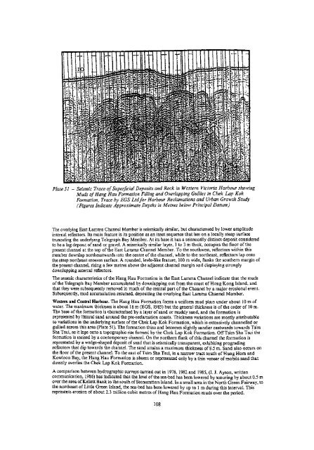
Plate 51 - Seismic Trace of <strong>Superficial</strong> Deposits and Rock in Western Victoria Harbour showing<br />
Muds of Hang Hau Formation Filling and Overlapping Gullies in Chek Lap Kok<br />
Formation, Trace by EGS Ltd for Harbour Reclamations and Urban Growth Study<br />
(Figures Indicate Approximate Depths in Metres below Principal Datum)<br />
The overlying East Lamina Channel Member is seismically similar, but characterised by lower amplitude<br />
internal reflectors. Its main feature is its position as an inset sequence that lies on a locally steep surface<br />
truncating the underlying Telegraph Bay Member. At its base it has a seisrmcally distinct deposit considered<br />
to be a lag deposit of sand or gravel. A seismically similar layer, 1 to 3 m thick, occupies the floor of the<br />
present channel at the top of the East Lamma Channel Member. To the southwest, reflectors within this<br />
member downlap northeastwards into the centre of the channel, while to the northeast, reflectors lap onto<br />
the steep northeast erosion surface. A rounded, levee-like feature, 100 m wide, flanks the southern margin of<br />
the present channel, rising a few metres above the adjacent channel margin and displaying strongly<br />
downlapping internal reflectors.<br />
The seismic characteristics of the Hang Hau Formation in the East Lamma Channel indicate that the muds<br />
of the Telegraph Bay Member accumulated by downlapping out from the coast of Hong Kong Island, and<br />
that they were subsequently removed in much of the central part of the Channel by a major erosional event.<br />
Subsequently, mud accumulation resumed, depositing the overlying East Lamma Channel Member.<br />
Western and Central Harbour. The Hang Hau Formation forms a uniform mud plain under about 10 m of<br />
water. The maximum thickness is about 18 m (EGS, 1985) but the general thickness is of the order of 10 m.<br />
The base of the formation is characterised by a layer of sand or muddy sand, and the formation is<br />
represented by littoral sand around the pre-reclamation coasts. Thickness variations are mostly attributable<br />
to variations in the underlying surface of the Chek Lap Kok Formation, which is extensively channelled or<br />
gullied across this area (Plate 51). The formation thins and becomes slightly sandier eastwards towards Tsim<br />
Sha Tsui, as it laps onto a topographic rise formed by the Chek Lap Kok Formation. Off Tsim Sha Tsui the<br />
formation is incised by a contemporary channel. On the northern flank of this channel the formation is<br />
represented by a wedge-shaped deposit of sand that is seismically transparent, exhibiting prograding<br />
reflectors that dip towards the channel The sand attains a maximum thickness of 8.5 m. Sand also occurs on<br />
the floor of the present channel. To the east of Tsim Sha Tsui, in a narrow tract south of Hung Horn and<br />
Kowloon Bay, the Hang Hau Formation is absent or represented only by a thin veneer of mobile sand that<br />
directly overlies the Chek Lap Kok Formation.<br />
A comparison between hydrographic surveys carried out in 1978, 1982 and 1985, (I. J. Ayson, written<br />
communication, 1986) has indicated that the level of the sea-bed has been lowered by scouring by about 0.5 m<br />
over the area of Kellett Bank to the south of Stonecutters Island. In a small area in the North Green Fairway, to<br />
the northeast of Little Green Island, the sea-bed has been lowered by up to 1 m during this interval. This<br />
represents erosion of about 2.3 million cubic metres of Hang Hau Formation muds over the period.<br />
108


