

Superficial Geology
Superficial Geology
Superficial Geology

You also want an ePaper? Increase the reach of your titles
YUMPU automatically turns print PDFs into web optimized ePapers that Google loves.
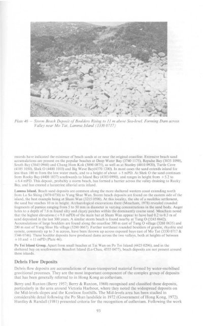
- Storm Beach Deposit of Boulders Rising to 11 m above Sea-level. Forming Dam across<br />
Valley near Mo Tat, Lamma Island (3330 0717)<br />
records have indicated the existence of beach sands at or near the original coastline. Extensive beach sand<br />
accumulations are present on the popular beaches at Deep Water Bay (3740 1175), Repulse Bay (3835 1090),<br />
South Bay (3845 0960) and Chung Horn Kok (3890 0875), as well as at Stanley (4010 0920), Turtle Cove<br />
(4105 1050), Shek O (4400 1010) and Big Wave Bay(4370 1200). In most cases the sand extends inland for<br />
less than 100 m from the low water mark, and to a height of about +5 mPD. At Shek O the sand continues<br />
from Rocky Bay (4400 1037) southwards to Island Bay (4383 0990), and ranges in height from +5.2 to<br />
+ 6.4 mPD. This deposit, probably a storm beach, has formed a barrier across the valley draining to Rocky<br />
Bay, and has created a lacustrine alluvial area inland.<br />
Lamma Island. Beach sand deposits are common along the more sheltered western coast extending north<br />
from Lo So Shing (3070 0730) to Yung Shue Wan. Storm beach deposits are found on the eastern side of the<br />
island, the best example being at Sham Wan (3215 0590). At this locality, the site of a neolithic settlement,<br />
the sand bar reaches 10 m in height. Archaeological excavations there (Meacham, 1978) revealed rounded<br />
fragments of pumice ranging from 5 to 50 mm in diameter in varying concentrations in the sand body. Auger<br />
holes to a depth of 7.6 m found silty and clayey patches within the dominantly coarse sand. Meacham noted<br />
that the highest elevations ( + 9.8 mPD) of the main bar at Sham Wan appear to have had 0.2 to 0.3 m of<br />
sand deposited in the last 300 years. A similar storm beach is found nearby at Tung O (3243 0642).<br />
Accumulations of large boulders are found along the coastline 300 m east of Tung O village (3268 0635) and<br />
200 m east of Yung Shue Ha village (3280 0667). Farther northeast rounded boulders of granite, rhyolite and<br />
syenite, commonly up to 3 m across, have been thrown up across exposed bays east of Mo Tat (3330 0717 &<br />
3346 0746). These boulder deposits have produced dams across the two valleys, both at heights of between<br />
+ 10 and +11 mPD (Plate 46).<br />
Po Toi Island Group. Apart from small beaches at Tai Wan on Po Toi Island (4425 0296), and in the<br />
sheltered bay on southwestern Beaufort Island (Lo Chau, 4335 0477), beach deposits are not present around<br />
these islands.<br />
Debris Flow Deposits<br />
Debris flow deposits are accumulations of mass-transported material formed by water-mobilised<br />
gravitional processes. They are the most important component of the complex group of deposits<br />
that has been generally referred to in Hong Kong as colluvium.<br />
Berry and Ruxton (Berry 1957; Berry & Ruxton, 1960) recognised and classified these deposits,<br />
particularly in the area around Victoria Harbour, where they noted the widespread deposits on<br />
the Mid-levels slopes and the Kowloon foothills. The Mid-levels area has been studied in<br />
considerable detail following the Po Shan landslide in 1972 (Government of Hong Kong, 1972).<br />
Huntley & Randall (1981) presented criteria for the recognition of colluvium. Following the work<br />
93


