Book 5:Lee County Storm Tide Atlas - Southwest Florida Regional ...
Book 5:Lee County Storm Tide Atlas - Southwest Florida Regional ...
Book 5:Lee County Storm Tide Atlas - Southwest Florida Regional ...

You also want an ePaper? Increase the reach of your titles
YUMPU automatically turns print PDFs into web optimized ePapers that Google loves.
<strong>Florida</strong> Rd<br />
Idaho Rd<br />
California Rd<br />
Piper Dr<br />
Dakota Rd<br />
Kentucky Rd<br />
Elwell Dr<br />
Louisiana Rd<br />
Virginia Rd<br />
Rand Dr<br />
Lois Way<br />
Illinois Rd<br />
Vermont Way<br />
Rainier Ave<br />
Maryland Rd<br />
Ranch Ave<br />
Rancho Ave<br />
Ranchijo Ave<br />
Michigan Rd<br />
Texas Rd<br />
Rawlings Dr<br />
McKinley Ave<br />
Schoolside Dr<br />
McKinley Ave<br />
Clayton Ave<br />
Clayton Ave<br />
Calvin Ave<br />
Schoolside Ct<br />
Richmond Ave<br />
5th Ave<br />
5th Ave<br />
5th Ave<br />
Lincoln Ave<br />
Lincoln Ave<br />
Lincoln Ave<br />
Greenwood Ave<br />
Greenwood Ave<br />
Greenwood Ave<br />
8th Ave<br />
8th Ave<br />
Lake Ave<br />
Lake Ave<br />
Maple Ave<br />
Maple Ave<br />
Maple Ave<br />
Highland Ave<br />
Highland Ave<br />
Highland Ave<br />
Eben Dr<br />
North Ave<br />
North Ave<br />
North Ave<br />
Victoria Ave<br />
Thompson Ave<br />
Thompson Ave<br />
Castle<br />
Corvet Ave<br />
Lancelot Ave<br />
Verdun<br />
Washington Ave<br />
Washington Ave<br />
Ogden Ave<br />
Larose Ave<br />
Lomax Ave<br />
Cleveland Ave<br />
Lausanne Ave<br />
Larua Ave<br />
Moraine Dr<br />
Broadway Ave<br />
Broadway Ave<br />
Malden Ave<br />
Laurel Ave<br />
Pinola Ave<br />
Leruth Ave<br />
Dayton Ave<br />
Beckley Dr<br />
Lillon Ave<br />
Alexander Graham Bell Blvd<br />
Wanatah Ave<br />
Thomas Sherwin Ave<br />
Sheldon Ave<br />
Baize Ave<br />
Lloyd Ave<br />
Lenz Ave<br />
Hagan Ave<br />
Luke Ave<br />
James Ave<br />
Argonne Ave<br />
Country Club Pkwy<br />
74<br />
81°38'0"W<br />
77<br />
81°37'0"W 81<br />
84<br />
81°36'0"W<br />
7th St<br />
6th St<br />
Cleveland Ave<br />
Glenn Ave<br />
Michael Ave<br />
Magnolia Ave<br />
Edison Ave<br />
Poinsettia Ave<br />
Plumosa Ave<br />
Hibiscus Ave<br />
Palmetto Ave<br />
Desoto Ave<br />
Prospect Ave<br />
Cortez Ave<br />
Henry Ave<br />
Willard Ave<br />
30 30<br />
26°37'0"N<br />
5th St<br />
Golfside Village D r<br />
26°37'0"N<br />
Lincoln B<br />
lvd<br />
Stanford St<br />
4th St<br />
Sidney St<br />
Gre ens Blvd<br />
UV 884 UV 873 81°36'0"W<br />
Greens Cir<br />
Dartmouth Ave<br />
Delaware Rd<br />
Alcala Ave<br />
Valley Dr<br />
Ohio Rd<br />
Maine Pl<br />
Monroe Dr<br />
Taylor Ln<br />
Coolidge Ave<br />
Georgia Rd<br />
Grant Ln<br />
Fillmore Ave<br />
Arkansas Rd<br />
Adams Ave<br />
Willow St<br />
Andros St<br />
Palm Blvd<br />
Connecticut Rd<br />
<strong>Lee</strong> Blvd<br />
<strong>Lee</strong>land Heights Blvd<br />
Arlingford Blvd<br />
Colorado Rd<br />
Pinewood Blvd<br />
Laurel P ark Dr<br />
Arthur Ave<br />
Harrison Dr<br />
Jefferson Dr<br />
Y o<br />
rk Rd<br />
Wyoming Rd<br />
Ste w a<br />
Penn Rd<br />
Ste<br />
Davis Rd<br />
Oregon Rd<br />
Pu rdue St<br />
Oleander Rd<br />
3rd St<br />
tson St<br />
27 27<br />
26°36'0"N<br />
Tangelo Ct<br />
Hamlin C<br />
Temple C<br />
t<br />
t<br />
Cactu s Cir<br />
Jackson Ln<br />
Jacatree Ct<br />
Heath Aster Ln<br />
Figtree Ct<br />
Poppytree Ct<br />
Garfield Ave<br />
Guavatree Ct<br />
Jersey Rd<br />
rt Ln<br />
Massachusetts Rd<br />
Drivewa y<br />
Unnamed Street<br />
Airview Ave<br />
Jasmine Rd<br />
Homestead Rd<br />
Roat St<br />
Jersey Rd<br />
Calvin Ave<br />
Brookside St<br />
Corinne Dr<br />
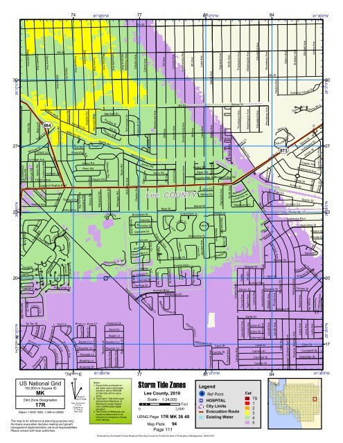
<strong>Lee</strong> COUNTY<br />
Oakside St<br />
B urnside St<br />
Gateside St<br />
Ground Dove Cir<br />
Jayside Ln<br />
Doveside Ln<br />
Marby Rd<br />
Layton Pl<br />
Noridge Dr<br />
Bethany Village Cir<br />
Penn Rd<br />
Daleview Ave<br />
Danby Rd<br />
Highview Ave<br />
Bear St<br />
Sunrise Blvd<br />
Pen n view Ave<br />
Lake Dr<br />
Parkside St<br />
Genevieve Dr<br />
Bethan y H ome Dr<br />
Plainfield St<br />
Laurent Ct<br />
Grandview Dr<br />
Lake Dr<br />
Lhommedieu St<br />
Monet St<br />
Shadyside St<br />
Weston Rd<br />
Jersey Rd<br />
Penn Rd<br />
Bougainvillea Rd<br />
Lake Dr<br />
Jayview Ave<br />
Juno Dr<br />
Willow Dr<br />
La k e Dr<br />
Hillside St<br />
Gardenside Ct<br />
Starview Ave<br />
Briar Ct<br />
Bougainvillea Rd<br />
Maple Ave<br />
Randy Ln<br />
David Ave<br />
Baldwin Pl<br />
Crestview Pl<br />
Albemarle Cir<br />
Sawyer St<br />
Devon St<br />
Bell Blvd<br />
Sunrise Blvd<br />
Bermont Ave<br />
Hampton Ave<br />
Supine Ct<br />
Clay Ct<br />
Joel Blvd<br />
Testerman Ct<br />
Herndon Ave<br />
Otter St<br />
Dundee St<br />
New<br />
Ford Cir<br />
land Dr<br />
Oakri dge Cir<br />
Palmer St<br />
Ashland St<br />
Canal St<br />
Archer St<br />
Graham Cir<br />
Porter St<br />
Sentinella Blvd<br />
Dania St<br />
Hollywood St<br />
Inman St<br />
Flagler Ave<br />
Englewood Ave<br />
23 23<br />
20 20<br />
Scenic St<br />
Spaulding St<br />
Wabash St<br />
W arren St<br />
Carson St<br />
Lynne St<br />
Suffolk Ct<br />
Geneva St<br />
Carlisle Ave<br />
Pierce St<br />
Kildare St<br />
Kidvale St<br />
Casey Ter<br />
Homewood Ave<br />
26°36'0"N<br />
Alabama Rd<br />
Cadis St<br />
8 17<br />
235m.N 26°35'0"N<br />
Tol Tec St<br />
Philbert Pl<br />
Ecclese Dr<br />
Emrose Pl<br />
Elwin Dr<br />
Peerless St<br />
Pinehurst Ave<br />
Peerless S t<br />
Pinafore Ave<br />
Cyril Ln<br />
US National Grid<br />
100,000-m Square ID<br />
MK<br />
Grid Zone Designation<br />
17R<br />
Datum = NAD 1983, 1,000-m USNG<br />
Progress Ave<br />
Rarer Dr<br />
Redford Ave<br />
Enon Ln<br />
7<br />
74 585m. E<br />
^<br />
GN<br />
#<br />
Enon Ln<br />
Rayford Ln<br />
Raymer Ln<br />
Rayneta Ln<br />
Reading Ln<br />
Redwing St<br />
Diagram<br />
Not to Scale<br />
Mag. Declination<br />
4 0 31'W<br />
Changing by<br />
5' W per yr<br />
Date 2009<br />
This map is for reference & planning purposes only.<br />
Hurricane evacuation decision-making and growth<br />
management implementation are local responsibilities.<br />
Please consult with local authorities.<br />
81°38'0"W<br />
Paddock St<br />
Rand St<br />
Rajah Ln<br />
Rayford Ln<br />
Raymer Ln<br />
Notes:<br />
1. Surge limits are based on<br />
still water storm tide height<br />
elevation above NAVD88<br />
at high tide with no wave<br />
setup.<br />
2. Total <strong>Storm</strong> <strong>Tide</strong> limits were<br />
derived from Maximum of<br />
Maximums surge heights<br />
over LIDAR based digital<br />
elevation.<br />
3. The Points of Reference are<br />
locations determined to be<br />
relevant to emergency managment<br />
officials.<br />
77<br />
<strong>Storm</strong> <strong>Tide</strong> Zones<br />
<strong>Lee</strong> <strong>County</strong>, 2010<br />
Scale - 1:24,000<br />
Feet<br />
0 2,000<br />
USNG Page 17R MK 36 40<br />
Map Plate 94<br />
Page 111<br />
A<br />
ttenboro Ln<br />
Willingboro Dr<br />
Charwood Ave<br />
Cane St<br />
Camilla St<br />
81 81°37'0"W<br />
Legend<br />
!( ! Ref Point<br />
®v HOSPITAL<br />
City Limits<br />
Evacuation Route<br />
Existing Water<br />
Chalet Ave<br />
Labree Ave<br />
Cahn St<br />
Cairo St<br />
Calumet St<br />
Cat<br />
TS<br />
1<br />
2<br />
3<br />
4<br />
5<br />
Cane St<br />
Camilla St<br />
Cardinal St<br />
Carbon St<br />
84<br />
147<br />
132<br />
148<br />
133<br />
82<br />
65<br />
48<br />
32<br />
16<br />
83<br />
66<br />
49<br />
33<br />
17<br />
84<br />
67<br />
50<br />
34<br />
18<br />
85<br />
68<br />
51<br />
35<br />
19<br />
86<br />
69<br />
52<br />
36<br />
20<br />
87<br />
70<br />
53<br />
37<br />
21<br />
88<br />
71<br />
54<br />
38<br />
22<br />
Clow St<br />
Campbell St<br />
Carpenter St<br />
114 115 116 117 118 119 120 121 122 123 124 125 126 127 128 129 130 131<br />
96 97 98 99 100 101 102 103 104 105 106 107 108 109 110 111 112 113<br />
79<br />
62<br />
80<br />
63<br />
46<br />
30<br />
14<br />
81<br />
64<br />
47<br />
31<br />
15<br />
149<br />
134<br />
150<br />
135<br />
151<br />
136<br />
152<br />
137<br />
153<br />
138<br />
154<br />
139<br />
7 8 9 10 11<br />
1<br />
155<br />
140<br />
89<br />
72<br />
55<br />
39<br />
23<br />
2<br />
156<br />
141<br />
90<br />
73<br />
56<br />
40<br />
24<br />
3<br />
157<br />
142<br />
91<br />
74<br />
57<br />
41<br />
25<br />
4<br />
158<br />
143<br />
92<br />
75<br />
58<br />
42<br />
26<br />
12<br />
5<br />
159<br />
144<br />
93<br />
76<br />
59<br />
43<br />
27<br />
13<br />
6<br />
160<br />
145<br />
94<br />
77<br />
60<br />
44<br />
28<br />
161<br />
146<br />
95<br />
78<br />
61<br />
45<br />
29<br />
26°35'0"N<br />
17<br />
Produced by <strong>Southwest</strong> <strong>Florida</strong> <strong>Regional</strong> Planning Council for <strong>Florida</strong> Division of Emergency Management, 2009-2010