Book 5:Lee County Storm Tide Atlas - Southwest Florida Regional ...
Book 5:Lee County Storm Tide Atlas - Southwest Florida Regional ...
Book 5:Lee County Storm Tide Atlas - Southwest Florida Regional ...

You also want an ePaper? Increase the reach of your titles
YUMPU automatically turns print PDFs into web optimized ePapers that Google loves.
Marwood Ave<br />
Maiden St<br />
Overland Ave<br />
Montero Ave<br />
Holyoke Ave<br />
Driveway<br />
Kester Ave<br />
Morley St<br />
Hester Ave<br />
Lemon Ave<br />
Milstead Ave<br />
Owanita Dr<br />
Loyola Ave<br />
Welk St<br />
Tuxford Ave<br />
Safe Harbour Ct<br />
Octavia St<br />
Waylife Ct<br />
Leavitt Rd<br />
Miller St<br />
Tulip St<br />
Gardner Rd<br />
Urbana St<br />
Lippincott Rd<br />
La<br />
Tiara Ct<br />
Reno Ct<br />
Broadway St<br />
Weller Ave<br />
Driveway<br />
Styles Rd<br />
Driveway<br />
Joel Blvd<br />
Whitman Ave<br />
Mill St<br />
River Rd<br />
River Rd<br />
74<br />
81°38'0"W<br />
Driveway<br />
Wagner Rd<br />
77<br />
81°37'0"W 81<br />
Julia Ave<br />
High St<br />
84<br />
Pearl St<br />
Sebastian Ct<br />
Sunset Trl<br />
Owanita Rd<br />
Unnamed Street<br />
Casaly St<br />
Herzog Rd<br />
Little Ln<br />
Palm Beach Blvd<br />
UV 80<br />
63 63<br />
C har<br />
l e s St<br />
Driveway<br />
Oakley Clark Rd<br />
Goggin Dr<br />
Edwards Dr<br />
Goggin Rd<br />
Dri veway<br />
Lucky <strong>Lee</strong> Ln<br />
Packinghouse Rd<br />
26°42'0"N<br />
Tringali Ln<br />
59 59<br />
Wi ts End<br />
Tuckahoe Rd<br />
26°42'0"N<br />
Lonesome Ln<br />
Langford Rd<br />
<strong>Lee</strong> COUNTY<br />
Meyrick Ln<br />
Buck Crest Ln<br />
56 56<br />
26°41'0"N<br />
Julian St<br />
Rolling Dr<br />
Regalo Ct<br />
Lakeridge Blvd<br />
McLean Cir<br />
Marney Ct<br />
W<br />
Ursula Ln<br />
alsh C<br />
ir<br />
Unnamed St reet<br />
Tyrone Ave<br />
Vantage St<br />
Viscount Ave<br />
Winnetka Dr<br />
Unnamed Street<br />
Wyandotte Way<br />
Kleinart Dr<br />
Wyandotte A ve<br />
26°41'0"N<br />
53 53<br />
8 50<br />
044m.N<br />
Quintero Ln<br />
Myers Richla nd Ave<br />
Vienna St<br />
Roscoe St<br />
Merrywood Ave<br />
Mayberry Dr<br />
S argent St<br />
Roderick Ln<br />
Woodman Dr<br />
Tobin St<br />
Twe e d Ct<br />
Windmere Dr<br />
Tremaine St<br />
Woodman Dr<br />
Westdale Ave<br />
Westchester Ln<br />
Willowbrook Dr<br />
Thelma Ct<br />
Vesper Ct<br />
Trudy St<br />
Muriel St<br />
Valmo nt St<br />
Mecedes Ct<br />
Olanda St<br />
Richmond Ave<br />
Villa St<br />
Victor Ln<br />
Ottoman Ln<br />
Rockland St<br />
Lavenn a Ave<br />
Reeves St<br />
Wooburn Dr<br />
Sapphire St<br />
Magenta Ave<br />
Montana St<br />
Lindenwood Dr<br />
Justice Ave<br />
tona St<br />
Vicksburg Ave<br />
Greenbriar Blvd<br />
Clarette Dr<br />
Ginger St<br />
Ney Ct<br />
Townsend Ct<br />
Victory Ct<br />
Rosa Ct<br />
Ocean Park Dr<br />
Marlay Ave<br />
Ridgemont Dr<br />
Welby Ct<br />
S anborn Dr<br />
Vie wpoint Dr<br />
Titus Ct<br />
50<br />
Vanetta Dr<br />
McClure St<br />
Unnamed Street<br />
Nutmeg St<br />
Mines St<br />
Murphy Ave<br />
Long Beach Dr<br />
U nnamed Street<br />
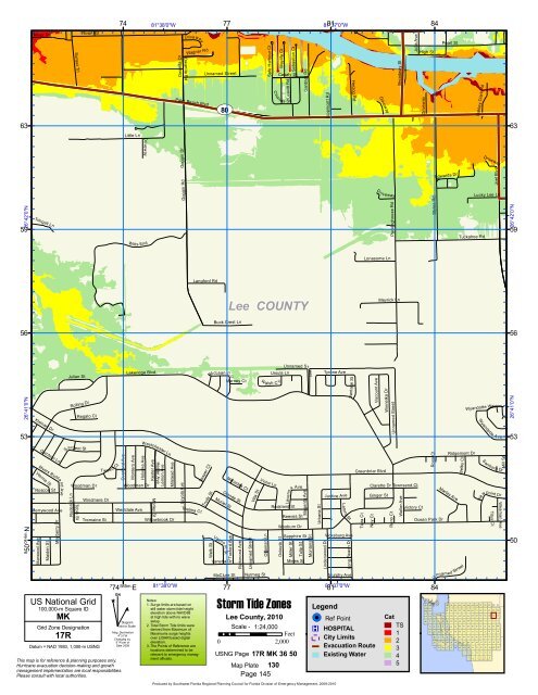
US National Grid<br />
100,000-m Square ID<br />
MK<br />
Grid Zone Designation<br />
17R<br />
Datum = NAD 1983, 1,000-m USNG<br />
7<br />
74 585m. E<br />
^<br />
GN<br />
#<br />
Diagram<br />
Not to Scale<br />
Mag. Declination<br />
4 0 31'W<br />
Changing by<br />
5' W per yr<br />
Date 2009<br />
This map is for reference & planning purposes only.<br />
Hurricane evacuation decision-making and growth<br />
management implementation are local responsibilities.<br />
Please consult with local authorities.<br />
81°38'0"W<br />
Notes:<br />
1. Surge limits are based on<br />
still water storm tide height<br />
elevation above NAVD88<br />
at high tide with no wave<br />
setup.<br />
2. Total <strong>Storm</strong> <strong>Tide</strong> limits were<br />
derived from Maximum of<br />
Maximums surge heights<br />
over LIDAR based digital<br />
elevation.<br />
3. The Points of Reference are<br />
locations determined to be<br />
relevant to emergency managment<br />
officials.<br />
77<br />
<strong>Storm</strong> <strong>Tide</strong> Zones<br />
<strong>Lee</strong> <strong>County</strong>, 2010<br />
Scale - 1:24,000<br />
Feet<br />
0 2,000<br />
USNG Page 17R MK 36 50<br />
Map Plate 130<br />
Page 145<br />
81°37'0"W<br />
Legend<br />
!( ! Ref Point<br />
®v HOSPITAL<br />
City Limits<br />
Evacuation Route<br />
Existing Water<br />
Cat<br />
TS<br />
1<br />
2<br />
3<br />
4<br />
5<br />
84<br />
147 148<br />
149 150 151 152 153 154 155 156 157 158 159 160 161<br />
132 133<br />
134 135 136 137 138 139 140 141 142 143 144 145 146<br />
114 115 116 117 118 119 120 121 122 123 124 125 126 127 128 129 130 131<br />
96 97 98 99 100 101 102 103 104 105 106 107 108 109 110 111 112 113<br />
79 80 81 82 83 84 85 86 87 88 89 90 91 92 93 94 95<br />
62 63 64 65 66 67 68 69 70 71 72 73 74 75 76 77 78<br />
46 47 48 49 50 51 52 53 54 55 56 57 58 59 60 61<br />
30 31 32 33 34 35 36 37 38 39 40 41 42 43 44 45<br />
14 15 16 17 18 19 20 21 22 23 24 25 26 27 28 29<br />
7 8 9 10 11 12 13<br />
1 2 3 4 5 6<br />
Produced by <strong>Southwest</strong> <strong>Florida</strong> <strong>Regional</strong> Planning Council for <strong>Florida</strong> Division of Emergency Management, 2009-2010