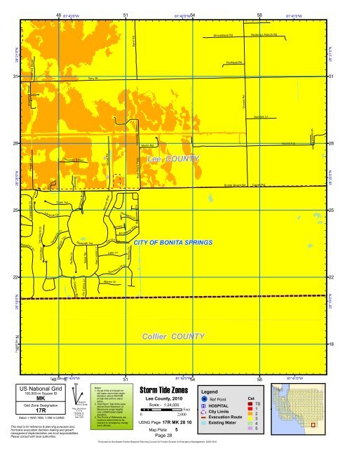
Book 5:Lee County Storm Tide Atlas - Southwest Florida Regional ...
Book 5:Lee County Storm Tide Atlas - Southwest Florida Regional ...
Book 5:Lee County Storm Tide Atlas - Southwest Florida Regional ...

Create successful ePaper yourself
Turn your PDF publications into a flip-book with our unique Google optimized e-Paper software.
Faygin Ln<br />
Azzili Way<br />
Raffini Ln<br />
Talori Ter<br />
48 81°43'0"W<br />
51<br />
81°42'0"W54<br />
58<br />
81°41'0"W<br />
Shovelhead Rd<br />
Rocking L Ranch Rd<br />
Sand Rd<br />
26°21'0"N<br />
Unnamed Street<br />
31 31<br />
Terry St<br />
Panhead Rd<br />
26°21'0"N<br />
Unnamed Street<br />
Vincent Rd<br />
Sundew Ln<br />
Unnamed Street<br />
Unnamed Street<br />
28 28<br />
Murlin Rd<br />
Harrell Ave<br />
Unn amed Street<br />
<strong>Lee</strong> COUNTY<br />
Vincet Rd<br />
Poor Mans Pass<br />
26°20'0"N<br />
Driveway<br />
Driveway<br />
Lavante Ct<br />
Tivoli Ter<br />
Driveway<br />
Palmira B<br />
lvd<br />
Benicia Blvd<br />
Bonita Beach Rd Carrell Rd<br />
25 25<br />
26°20'0"N<br />
Cavendish Ct<br />
Blaisdell Dr<br />
Ventanas Ct<br />
Chianti Ter<br />
Ma<br />
tteotti Vw<br />
Carino Ter<br />
Lieto Ln<br />
Es calante Way<br />
Risorsa Pl<br />
Alessandria Cir<br />
Donatello C<br />
t<br />
Via Odanti Dr<br />
Ferrara Ct<br />
CITY OF BONITA SPRINGS<br />
San Lucas Ln<br />
26°19'0"N<br />
San Galgano Way<br />
Via Carino Ln<br />
S peranz a W ay<br />
22 22<br />
Meravi Dr<br />
26°19'0"N<br />
7 18<br />
810m.N<br />
Collier COUNTY<br />
18<br />
US National Grid<br />
100,000-m Square ID<br />
MK<br />
Grid Zone Designation<br />
17R<br />
Datum = NAD 1983, 1,000-m USNG<br />
7<br />
48 338m. 81°43'0"W E<br />
^<br />
GN<br />
#<br />
Diagram<br />
Not to Scale<br />
Mag. Declination<br />
4 0 31'W<br />
Changing by<br />
5' W per yr<br />
Date 2009<br />
This map is for reference & planning purposes only.<br />
Hurricane evacuation decision-making and growth<br />
management implementation are local responsibilities.<br />
Please consult with local authorities.<br />
51<br />
Notes:<br />
1. Surge limits are based on<br />
still water storm tide height<br />
elevation above NAVD88<br />
at high tide with no wave<br />
setup.<br />
2. Total <strong>Storm</strong> <strong>Tide</strong> limits were<br />
derived from Maximum of<br />
Maximums surge heights<br />
over LIDAR based digital<br />
elevation.<br />
3. The Points of Reference are<br />
locations determined to be<br />
relevant to emergency managment<br />
officials.<br />
81°42'0"W54<br />
<strong>Storm</strong> <strong>Tide</strong> Zones<br />
<strong>Lee</strong> <strong>County</strong>, 2010<br />
Scale - 1:24,000<br />
Feet<br />
0 2,000<br />
USNG Page 17R MK 28 10<br />
Map Plate 5<br />
Page 28<br />
Legend<br />
!( ! Ref Point<br />
®v HOSPITAL<br />
City Limits<br />
Evacuation Route<br />
Existing Water<br />
58<br />
Cat<br />
TS<br />
1<br />
2<br />
3<br />
4<br />
5<br />
81°41'0"W<br />
147 148<br />
149 150 151 152 153 154 155 156 157 158 159 160 161<br />
132 133<br />
134 135 136 137 138 139 140 141 142 143 144 145 146<br />
114 115 116 117 118 119 120 121 122 123 124 125 126 127 128 129 130 131<br />
96 97 98 99 100 101 102 103 104 105 106 107 108 109 110 111 112 113<br />
79 80 81 82 83 84 85 86 87 88 89 90 91 92 93 94 95<br />
62 63 64 65 66 67 68 69 70 71 72 73 74 75 76 77 78<br />
46 47 48 49 50 51 52 53 54 55 56 57 58 59 60 61<br />
30 31 32 33 34 35 36 37 38 39 40 41 42 43 44 45<br />
14 15 16 17 18 19 20 21 22 23 24 25 26 27 28 29<br />
7 8 9 10 11 12 13<br />
1 2 3 4 5 6<br />
Produced by <strong>Southwest</strong> <strong>Florida</strong> <strong>Regional</strong> Planning Council for <strong>Florida</strong> Division of Emergency Management, 2009-2010