Book 5:Lee County Storm Tide Atlas - Southwest Florida Regional ...
Book 5:Lee County Storm Tide Atlas - Southwest Florida Regional ...
Book 5:Lee County Storm Tide Atlas - Southwest Florida Regional ...

You also want an ePaper? Increase the reach of your titles
YUMPU automatically turns print PDFs into web optimized ePapers that Google loves.
Ruth Ave<br />
Pat Ave<br />
Inez Ave<br />
Joan Ave<br />
Judy Ave<br />
Driveway<br />
Nora Ln<br />
Ida Ave<br />
Ida Ave<br />
Elaine Ave<br />
Zeligro Rd<br />
Beth Ave<br />
Sunshine Blvd<br />
Dixie Ln<br />
Bateman Rd<br />
Maurice Ave<br />
Newtonia St<br />
Marwood Ave<br />
Maiden St<br />
Tobin St<br />
81°41'0"W<br />
61<br />
81°40'0"W 64<br />
68<br />
81°39'0"W<br />
71<br />
Mitchell Ave<br />
Rialto Way<br />
Sawyer Ln<br />
Balsey Rd<br />
Sunset Trl<br />
Snyder Dr<br />
Palm Beach Blvd<br />
Carter Ln<br />
Limpkin Ln<br />
Cook Ln<br />
Gideon Ln<br />
UV 80<br />
Hickey Creek Rd<br />
Driveway<br />
Bishop Dr<br />
Frank Rd<br />
63 63<br />
Little Ln<br />
Unnamed Street<br />
Oak Creek Rd<br />
Dri v ewa y<br />
26°42'0"N<br />
Unnamed Street<br />
59 59<br />
Tringali L n<br />
Unnamed Street<br />
26°42'0"N<br />
Unnamed S<br />
treet<br />
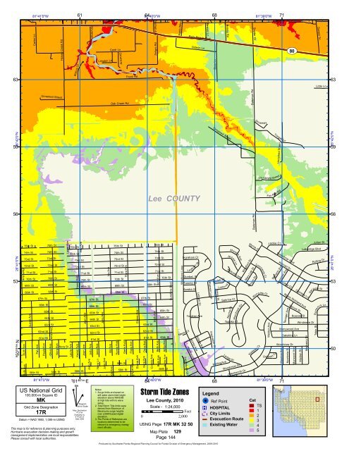
<strong>Lee</strong> COUNTY<br />
Fox Run Rd<br />
56 56<br />
Bateman Rd<br />
26°41'0"N<br />
8 50<br />
044m.N<br />
Ruth Ave<br />
Ruth Ave<br />
75th St<br />
74th St<br />
73rd St<br />
72nd St<br />
71st St<br />
70th St<br />
69th St<br />
68th St<br />
Queen Ave<br />
67th St<br />
66th St<br />
62nd St<br />
60st St<br />
Paula Ave<br />
75th St<br />
73rd St<br />
72nd St<br />
Olive Ave<br />
69th St<br />
68th St<br />
65th St<br />
64th St<br />
63rd St<br />
58th St 58th St<br />
81°41'0"W<br />
74th St<br />
71st St<br />
70th St<br />
Olive Ave<br />
Nora Ave<br />
Nora St<br />
Laura Ave<br />
Laura Ave<br />
75th St<br />
74th St<br />
73rd St<br />
72nd St<br />
Karen Ave<br />
Karen Ave<br />
58th St<br />
71st St<br />
70th St<br />
69th St<br />
7<br />
61 461m. E<br />
Joan Ave<br />
Judy Ave<br />
67th St<br />
66th St<br />
65th St<br />
64th St<br />
63rd St<br />
62nd St<br />
61st St<br />
Jane Ave<br />
June Ave<br />
June Ave<br />
Ida Ave<br />
75th St<br />
74th St<br />
73rd St<br />
72nd St<br />
Hanna Ave<br />
71st St<br />
70th St<br />
69th St<br />
68th St<br />
59th St<br />
Gene Ave<br />
58th St<br />
Flora Ave<br />
Flora Ave<br />
Gene Ave<br />
Elaine Ave<br />
67th St<br />
Dora Ave<br />
Dora Ave<br />
69th St<br />
66th St<br />
63rd St<br />
62nd St<br />
61st St<br />
Connie Ave<br />
Beth Ave<br />
75th St<br />
74th St<br />
73rd St<br />
72nd St<br />
71st St<br />
64 81°40'0"W<br />
Beth Ave<br />
Beth Ave<br />
70th St<br />
65th St<br />
64th St<br />
60th St<br />
Anita Ave<br />
Anita Ave<br />
58th St<br />
Westboro Loop<br />
Ingraham Ct<br />
Lockhaven Ct<br />
Le ghorn St<br />
Quebec St<br />
Tunney St<br />
Sandra St<br />
Menlo Ct<br />
Jacinto Ave<br />
Wentworth Dr<br />
Latham Dr<br />
Yucatan Ave<br />
Vintage Ave<br />
Stanwin Loop<br />
Inspiration Ct<br />
Kodak St<br />
Tobias St<br />
Lomo<br />
Kohler Ave<br />
68<br />
Norma Ct<br />
Topeka Ct<br />
Ledge St<br />
Morella Ave<br />
Je ssie Ln<br />
Wolcott Loop<br />
nd St<br />
Sabrina Ct<br />
Merchant Cir<br />
Woodcrest Dr<br />
Wentworth Dr<br />
Wingford Dr<br />
Myrna Ct<br />
Mary <strong>Lee</strong> St<br />
Miriam St<br />
Lombardy Ct<br />
Wyngate Ct<br />
Nadeau Ct<br />
Weldon Ave<br />
Outpos<br />
81°39'0"W<br />
Jackie Ct<br />
Greenbriar Blvd<br />
Mariano Ave<br />
t Cir<br />
Kleinart Dr<br />
Loleta Ct<br />
Messmer Ave<br />
Oakshire Ln<br />
Woodview Dr<br />
Vienna St<br />
Merrywood Ave<br />
Quintero Ln<br />
Myers Richland Ave<br />
Tanager Ave<br />
71<br />
Roscoe St<br />
Lakeridge Blvd<br />
53 53<br />
US National Grid<br />
100,000-m Square ID<br />
MK<br />
Grid Zone Designation<br />
17R<br />
Datum = NAD 1983, 1,000-m USNG<br />
^<br />
GN<br />
#<br />
Diagram<br />
Not to Scale<br />
Mag. Declination<br />
4 0 31'W<br />
Changing by<br />
5' W per yr<br />
Date 2009<br />
This map is for reference & planning purposes only.<br />
Hurricane evacuation decision-making and growth<br />
management implementation are local responsibilities.<br />
Please consult with local authorities.<br />
Notes:<br />
1. Surge limits are based on<br />
still water storm tide height<br />
elevation above NAVD88<br />
at high tide with no wave<br />
setup.<br />
2. Total <strong>Storm</strong> <strong>Tide</strong> limits were<br />
derived from Maximum of<br />
Maximums surge heights<br />
over LIDAR based digital<br />
elevation.<br />
3. The Points of Reference are<br />
locations determined to be<br />
relevant to emergency managment<br />
officials.<br />
<strong>Storm</strong> <strong>Tide</strong> Zones<br />
<strong>Lee</strong> <strong>County</strong>, 2010<br />
Scale - 1:24,000<br />
Feet<br />
0 2,000<br />
USNG Page 17R MK 32 50<br />
Map Plate 129<br />
Page 144<br />
Legend<br />
!( ! Ref Point<br />
®v HOSPITAL<br />
City Limits<br />
Evacuation Route<br />
Existing Water<br />
Cat<br />
TS<br />
1<br />
2<br />
3<br />
4<br />
5<br />
147<br />
132<br />
148<br />
133<br />
82<br />
65<br />
48<br />
32<br />
16<br />
83<br />
66<br />
49<br />
33<br />
17<br />
84<br />
67<br />
50<br />
34<br />
18<br />
85<br />
68<br />
51<br />
35<br />
19<br />
Windmere Dr<br />
86<br />
69<br />
52<br />
36<br />
20<br />
87<br />
70<br />
53<br />
37<br />
21<br />
Mayberry Dr<br />
88<br />
71<br />
54<br />
38<br />
22<br />
7 8 9 10 11<br />
1<br />
89<br />
72<br />
55<br />
39<br />
23<br />
2<br />
90<br />
73<br />
56<br />
40<br />
24<br />
3<br />
Julian St<br />
Rolling Dr<br />
Sargent St<br />
91<br />
74<br />
57<br />
41<br />
25<br />
4<br />
92<br />
75<br />
58<br />
42<br />
26<br />
12<br />
5<br />
Roderick Ln<br />
114 115 116 117 118 119 120 121 122 123 124 125 126 127 128 129 130 131<br />
96 97 98 99 100 101 102 103 104 105 106 107 108 109 110 111 112 113<br />
79<br />
62<br />
80<br />
63<br />
46<br />
30<br />
14<br />
81<br />
64<br />
47<br />
31<br />
15<br />
149<br />
134<br />
150<br />
135<br />
151<br />
136<br />
152<br />
137<br />
153<br />
138<br />
154<br />
139<br />
155<br />
140<br />
156<br />
141<br />
157<br />
142<br />
158<br />
143<br />
159<br />
144<br />
93<br />
76<br />
59<br />
43<br />
27<br />
13<br />
6<br />
160<br />
145<br />
94<br />
77<br />
60<br />
44<br />
28<br />
161<br />
146<br />
95<br />
78<br />
61<br />
45<br />
29<br />
26°41'0"N<br />
50<br />
Produced by <strong>Southwest</strong> <strong>Florida</strong> <strong>Regional</strong> Planning Council for <strong>Florida</strong> Division of Emergency Management, 2009-2010