gravesend riverside conservation area - Gravesham Borough Council
gravesend riverside conservation area - Gravesham Borough Council
gravesend riverside conservation area - Gravesham Borough Council

Create successful ePaper yourself
Turn your PDF publications into a flip-book with our unique Google optimized e-Paper software.
Gravesend Riverside<br />
Conservation Area Character Appraisal
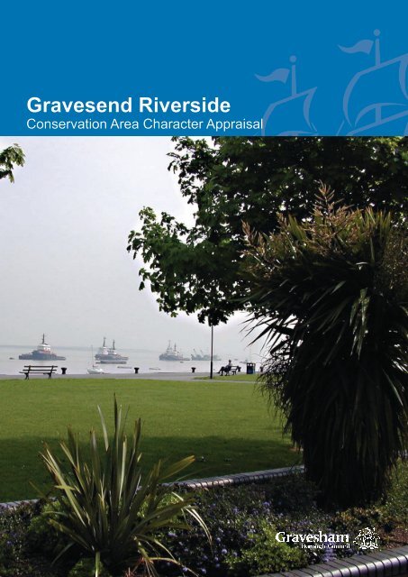
Cover: Gordon Promenade, Commercial Place, Gravesend Riverside Conservation Area
Riverside Conservation Area Appraisal 2009<br />
GRAVESEND RIVERSIDE<br />
CONSERVATION AREA<br />
Character Appraisal<br />
This document was prepared on behalf of <strong>Gravesham</strong> <strong>Borough</strong> <strong>Council</strong> based on an extensive<br />
survey dated 2007 by:<br />
The Conservation Studio<br />
1 Querns Lane<br />
Cirencester<br />
Gloucestershire<br />
GL7 1RL<br />
Tel: 01285 642428<br />
Email: info@the<strong>conservation</strong>studio.co.uk<br />
www.the<strong>conservation</strong>studio.co.uk<br />
Published by <strong>Gravesham</strong> <strong>Borough</strong> <strong>Council</strong> 2009<br />
Errata:<br />
Note that since undertaking this survey, the <strong>area</strong> of the Dell, referred to at pages 14, 23 and 26,<br />
has been re-landscaped and re-opened for the public.
Riverside Conservation Area Appraisal 2009<br />
CONTENTS<br />
1 Statement of Special Interest of the Conservation Area 1<br />
2 The Gravesend Riverside Conservation Area 3<br />
2.1 Background<br />
2.2 Purpose of the appraisal<br />
2.3 Planning policy context<br />
2.4 Community Involvement<br />
3 Location and Landscape Setting 6<br />
3.1 Geographic location<br />
3.2 Activities and uses<br />
3.3 Topography<br />
3.4 Geology and Biodiversity<br />
3.5 Relationship of the Conservation Area to its surroundings<br />
4 Historical Development 8<br />
4.1 Archaeology<br />
4.2 Historical development<br />
5 Spatial Analysis 13<br />
5.1 Layout and spaces<br />
5.2 Relationship of buildings to spaces<br />
5.3 Landmarks, focal points and views<br />
5.4 Trees, boundaries and planting<br />
6 Streetscape 16<br />
6.1 Public Realm
Riverside Conservation Area Appraisal 2009<br />
7 The buildings of the Conservation Area 18<br />
7.1 Building types<br />
7.2 Building form<br />
7.3 Listed buildings<br />
7.4 Locally listed buildings<br />
7.5 Key unlisted buildings<br />
7.6 Building Materials<br />
7.7 Local Details<br />
8 Character Areas 21<br />
8.1 Summary of Character Areas<br />
8.2 Character Area 1: Royal Pier Road and The Terrace<br />
8.3 Character Area 2: New Tavern Fort<br />
8.4 Character Area 3: Gordon Gardens and Promenade<br />
8.5 Character Area 4: Canal Basin<br />
9 Issues 24<br />
9.1 Definition of issues<br />
9.2 Conservation <strong>area</strong> boundary review<br />
9.3 Education and information<br />
9.4 Alterations to buildings<br />
9.5 Uses/ vitality<br />
9.6 Enforcement<br />
9.7 Locally listed buildings<br />
9.8 Highways and traffic<br />
9.9 Enhancement potential<br />
9.10 Trees<br />
9.11 Archaeological potential<br />
Appendices 27<br />
Appendix 1<br />
Appendix 2<br />
Appendix 3<br />
History of Gravesend<br />
Bibliography<br />
Townscape Appraisal Map<br />
Age of Buildings Map<br />
Designations Map<br />
Character Areas Map<br />
Conservation Area Boundary 2009
Riverside Conservation Area Appraisal 2009<br />
1<br />
1. STATEMENT OF THE<br />
SPECIAL INTEREST OF THE<br />
CONSERVATION AREA<br />
The Gravesend Riverside Conservation<br />
Area encompasses a long stretch of the<br />
Thames river frontage to the east of the town<br />
of Gravesend in Kent. The setting, close to<br />
London and at the mouth of the Thames<br />
estuary, defined the importance of Gravesend<br />
for many centuries. The town was the first<br />
port coming up the river toward London and<br />
a natural breaking point for ships on the<br />
tide. Traditionally, ships would land here on<br />
entering the river or complete victualling or<br />
embarking passengers before leaving.<br />
Because of this strategic importance,<br />
Gravesend was also chosen as a key<br />
defensive location on the river approach<br />
to London. Firstly, under Henry VIII the<br />
Gravesend Blockhouse was built. Later, in<br />
response to increased international tension<br />
at the end of the 18th century, the defences<br />
at Gravesend were strengthened with the<br />
construction of the New Tavern Fort to the<br />
east of Blockhouse. This fort lies at the hear of<br />
the Riverside Conservation Area. It remained<br />
in use and was substantially rebuilt in the<br />
19th century by Gravesend resident General<br />
Charles Gordon, whose famous deeds in<br />
China and Africa epitomise the image of the<br />
heroic Victorian military commander. His<br />
connection with Gravesend reinforces the<br />
town’s link with the maritime military, and the<br />
<strong>riverside</strong> <strong>area</strong> even retains the Mission House<br />
in which Gordon once taught.<br />
The Conservation Area celebrates the river<br />
and the relationship that the people of the<br />
town have had with it for many centuries.<br />
The historic buildings within the Conservation<br />
Area track the earliest settlement in the<br />
Parish of Milton to the beginnings of the New<br />
Town that was part of the early 19th century<br />
expansion of Gravesend. From the modest<br />
beginnings of a hospital and religious order<br />
at Milton Chantry, through a period of serving<br />
the commercial and official activities in the<br />
wharves and piers close by, to an established<br />
military and naval centre, the <strong>riverside</strong> has<br />
grown. To the east of this <strong>area</strong> another<br />
maritime hub also grew around the Canal<br />
Basin and this still provides an industrial<br />
focus to the Conservation Area, although it is<br />
in the process of transforming into a modern<br />
residential <strong>area</strong>.<br />
The section between the two historic cores<br />
has, since the late 19th century been provided<br />
for the enjoyment of the local people and its<br />
landscaped green open spaces have led to<br />
the <strong>area</strong> having a dominantly leisure based<br />
character. This character has extended<br />
to the Fort Gardens and the Canal Basin<br />
so that the primary characteristic is one of<br />
relaxation in a heritage setting close to the<br />
ancient thoroughfare and trading route of the<br />
River Thames. The wide open spaces and<br />
abundant trees, shrubs and flowers within the<br />
Conservation Area are as important as the<br />
panorama and historic uses of the waterway<br />
with which it connects.<br />
The <strong>riverside</strong> location itself is instrumental in<br />
the development of the town of Gravesend<br />
and the views out to Gravesend Reach mark<br />
the important role the <strong>area</strong> has played in<br />
international travel, trade and expansion<br />
for many centuries. Gravesend, Milton and<br />
Tilbury were key strategic positions close to<br />
the Thames estuary and the New Tavern Fort<br />
is of great national historic importance.<br />
The historic recreational activities in<br />
Gravesend continue in the social use of the<br />
parks, gardens and Fort and the naming of<br />
the recreation ground after General Gordon
Riverside Conservation Area Appraisal 2009<br />
recognises the military history of the <strong>area</strong>. The<br />
promenade still provides a clear connection<br />
with the river that has produced most of the<br />
town’s prosperity and the positive features<br />
of the environment, such as generous open<br />
spaces and groups of mature trees have<br />
encouraged the once declining industrial parts<br />
of the <strong>area</strong> to be regenerated into modern<br />
residential communities.<br />
The western part of the Conservation Area<br />
includes the later 19th century houses along<br />
The Terrace, Royal Pier Road and Clarendon<br />
Road which were developed on the site of<br />
the former Terrace Gardens. Their more<br />
formal urban arrangement in rows with front<br />
gardens is typical for its time and marks them<br />
as later infill during a period when many of<br />
the remaining open spaces within the town<br />
were developed to cater for a rapidly growing<br />
population at the end of the 19th century.<br />
2
Riverside Conservation Area Appraisal 2009<br />
3<br />
2. INTRODUCTION<br />
2.1 The Gravesend Riverside Conservation<br />
Area<br />
The Gravesend Riverside Conservation<br />
Area was designated on 18th December<br />
1980 by <strong>Gravesham</strong> <strong>Borough</strong> <strong>Council</strong>. It<br />
was extended on 14th February 2001. The<br />
Conservation Area’s boundary includes the<br />
Thames riverfront from the Port of London<br />
Authority buildings in the west to the entrance<br />
to the Canal Basin in the east. It also contains<br />
the historic residential streets of Royal Pier<br />
Road, The Terrace (part), Clarendon Road,<br />
Commercial Place and Canal Road (part), as<br />
well as the large New Tavern Fort and Gordon<br />
Recreation Ground.<br />
2.2 Purpose of the appraisal<br />
This <strong>conservation</strong> <strong>area</strong> appraisal has been<br />
written by The Conservation Studio on<br />
behalf of <strong>Gravesham</strong> <strong>Borough</strong> <strong>Council</strong>. It<br />
was prepared in September 2007 and<br />
was followed by a process of community<br />
engagement, which informed the content of<br />
this document. This appraisal defines the<br />
special architectural and historic interest for<br />
which the Gravesend Riverside Conservation<br />
Area merits designation. It identifies the<br />
positive features that should be protected and<br />
highlights the negative factors that detract<br />
from its character and appearance. It will be<br />
used by the <strong>Borough</strong> <strong>Council</strong> in considering<br />
proposals for demolition or alteration of<br />
buildings, as well as for new developments. It<br />
will also help property owners and developers<br />
to take account of the importance of buildings,<br />
features, spaces and landscape within and<br />
adjacent to the Conservation Area.<br />
This <strong>conservation</strong> <strong>area</strong> character appraisal,<br />
and those for the seven other town centre<br />
<strong>conservation</strong> <strong>area</strong>s in Gravesend, will lead<br />
to a Management Plan, setting out policies<br />
and actions to conserve and enhance their<br />
special architectural and historic interest<br />
and to mitigate the effects of negative<br />
features. The appraisals and Management<br />
Plans are to be included as background<br />
papers in the emerging Local Development<br />
Framework (LDF) and, as such, will be a<br />
due consideration in the planning process. In<br />
due course the appraisals and management<br />
plans may also be adopted as separate<br />
Supplementary Planning Documents within<br />
the LDF.<br />
Preparation of the appraisal involved an<br />
extensive survey of the <strong>conservation</strong> <strong>area</strong><br />
undertaken in July 2007. The omission of any<br />
particular feature does not imply that it is of no<br />
significance.<br />
2.3 Planning policy context<br />
Conservation Areas are defined as ‘<strong>area</strong>s of<br />
architectural or historic interest the character<br />
or appearance of which it is desirable to<br />
preserve or enhance’ in the Planning (Listed<br />
Buildings and Conservation Areas) Act<br />
1990 (The Act). Local Planning Authorities<br />
are required by the Act to identify the parts<br />
of their <strong>area</strong> that should be designated as<br />
<strong>conservation</strong> <strong>area</strong>s and to formulate and<br />
publish proposals to preserve or enhance<br />
them. Local authorities must submit<br />
proposals for the protection and enhancement<br />
of <strong>conservation</strong> <strong>area</strong>s for consideration at a<br />
public meeting within the relevant <strong>area</strong>. They<br />
must also have regard to any views expressed<br />
by people attending the meeting.<br />
Broadly, the effects of designation are:<br />
• Conservation Area Consent must<br />
be obtained from the local planning
Riverside Conservation Area Appraisal 2009<br />
4<br />
authority or Secretary of State prior to<br />
the substantial or total demolition of any<br />
building or structure within a <strong>conservation</strong><br />
<strong>area</strong>, with some exceptions;<br />
• The local planning authority must<br />
consider the desirability of preserving or<br />
enhancing the character or appearance<br />
of the <strong>conservation</strong> <strong>area</strong> when assessing<br />
applications for change in <strong>conservation</strong><br />
<strong>area</strong>s;<br />
• Permitted development rights are slightly<br />
different in <strong>conservation</strong> <strong>area</strong>s;<br />
• Permission is required from the planning<br />
authority to fell or lop a tree over a certain<br />
size.<br />
Further, more detailed information is provided<br />
in the Management Plan.<br />
As well as receiving statutory protection,<br />
<strong>conservation</strong> <strong>area</strong>s are protected by regional,<br />
county and local planning policies. Relevant<br />
policies include:<br />
• Regional Planning Guidance for the South<br />
East (RPG9) (published March 2001), Key<br />
Development Principle No.9; Policy Q2;<br />
Policy Q5; Policy Q7; Policy E1.<br />
• Regional Planning Guidance 9a: The<br />
Thames Gateway Planning Framework<br />
(1995), Paras. 5.4.7 & 5.4.8: Built<br />
Heritage, Annex 1: Planning Framework<br />
Principles No.13.<br />
• Draft South East Plan (Regional Spatial<br />
Strategy) (submitted to Government<br />
on 31st March 2006), Section D8<br />
Management of the Built and Historic<br />
Environment: Policy BE1; Policy BE2;<br />
Policy BE7; Section E4 (Kent Thames<br />
Gateway).<br />
• The Kent and Medway Structure Plan<br />
(adopted 6th July 2006), Policy QL1:<br />
Quality of Development and Design;<br />
Policy QL6: Conservation Areas; Policy<br />
QL7: Archaeological Sites; Policy QL8:<br />
Buildings of Architectural or Historic<br />
Importance; Policy QL9: Historic<br />
Landscape Features; Policy QL10:<br />
Heritage Assets – Enabling Development.<br />
• <strong>Gravesham</strong> Local Plan First Review<br />
(adopted November 1994), Policy TC0,<br />
TC1, TC2, TC3, TC4, TC5, TC6, TC7,<br />
TC8, TC9, TC10, TC11, TC12, Policy R3,<br />
Proposal PM13, Policy AP3.<br />
Thames Gateway<br />
In addition to the various <strong>conservation</strong> <strong>area</strong>s<br />
in the town, Gravesend is recognised as being<br />
in a Growth Area within the Kent Thames<br />
Gateway Sub-region by the Draft South East<br />
Plan of the South East Regional Assembly.<br />
The various policy documents outlined<br />
above have, since RPG9 (1994), recognised<br />
<strong>Gravesham</strong> and Gravesend’s important<br />
place in the Thames Gateway (incorporating<br />
the former East Thames Corridor). RPG9a<br />
emphasizes the importance of <strong>Gravesham</strong><br />
in achieving the Thames Gateway’s<br />
overall vision (para. 6.8.1) and that future<br />
development of industrial sites should “avoid<br />
adverse impacts on the historic townscape of<br />
Gravesend town centre and its relationship<br />
with the River Thames” (para. 6.8.14).<br />
The Thames Gateway is an overarching<br />
term for the regeneration of large parts of<br />
East London and parts of Essex and Kent,<br />
including Gravesend. It was first embarked on<br />
as a major planning concept in the 1980s and<br />
has developed at various stages since then.<br />
The Thames Gateway London Partnership<br />
estimates that the expected investment in the<br />
whole region will provide 150,000 jobs and<br />
200,000 homes over the next 10 years. The<br />
large scale of this scheme will see a great<br />
deal of change across the <strong>area</strong>, including<br />
the introduction of new large scale transport
Riverside Conservation Area Appraisal 2009<br />
infrastructure such as the Channel Tunnel<br />
Rail link (with a proposed connection to<br />
Gravesend) and major road building schemes<br />
such as the widening of the A2 south of the<br />
town.<br />
The policies included in the local and regional<br />
guidance as outlined above seek to guide<br />
this period of change and the specified<br />
policies all recognise the importance of<br />
retaining the built as well as natural heritage<br />
of Gravesend. This document identifies the<br />
special character of Gravesend’s built heritage<br />
and the accompanying Management Plan will<br />
propose how that special character can best<br />
be preserved and enhanced in the light of the<br />
large scale changes that are currently taking<br />
place in the <strong>area</strong>.<br />
Following the meeting, the outcomes were<br />
discussed by <strong>Gravesham</strong> <strong>Borough</strong> <strong>Council</strong><br />
and The Conservation Studio. Subsequently,<br />
a four week period of full public consultation<br />
was held after which revisions were made to<br />
arrive at this final agreed document. A public<br />
consultation report is attached as Appendix 4<br />
to this document.<br />
2.4 Community involvement<br />
The survey of the Conservation Area has<br />
included a process of public consultation to<br />
identify the following:<br />
• The special characteristics of Gravesend<br />
Riverside Conservation Area;<br />
• The key negative features and issues;<br />
• A range of possible actions that would<br />
mitigate or offset these detractors.<br />
5<br />
The consultation began with the notification<br />
of key stakeholders in Gravesend at the<br />
beginning of the appraisal process. It was<br />
followed by the distribution to every property<br />
in the <strong>conservation</strong> <strong>area</strong>s of an invitation to a<br />
public meeting held on 5th September 2007.<br />
Leaflets were also displayed in public places.<br />
The meeting included a description of the<br />
principal and desired outcomes of appraisals<br />
and management plans and led into a general<br />
discussion. The meeting was attended<br />
by various representatives of the <strong>Borough</strong><br />
<strong>Council</strong> and local interest groups.
Riverside Conservation Area Appraisal 2009<br />
6<br />
3. LOCATION AND LANDSCAPE<br />
SETTING<br />
3.1 Location<br />
Gravesend is the administrative capital of<br />
the <strong>Borough</strong> of <strong>Gravesham</strong>, which contains<br />
25,000 acres of countryside and is generally<br />
rural in appearance, containing a number<br />
of attractive historic villages. The town<br />
lies in north-west Kent, 40 kilometres to<br />
the east of central London. Canterbury is<br />
approximately 65 kilometres further along the<br />
Thames estuary coastline to the southeast<br />
and the major A2 and M2 trunk roads link<br />
the settlements. Due to the major transport<br />
infrastructure in the <strong>area</strong>, including the M25,<br />
M20 and the rail link to the Channel Tunnel,<br />
Gravesend is very well connected to other<br />
parts of the country and beyond.<br />
The Oxford Archaeological Unit’s Kent<br />
Historic Landscape Characterisation (2001),<br />
commissioned by Kent County <strong>Council</strong><br />
and English Heritage, and notes that: “The<br />
process of 19th and 20th century urbanisation<br />
is particularly marked in the northern <strong>area</strong>s<br />
of Kent”. The Dartford and <strong>Gravesham</strong><br />
Conurbation is characterised as “a well<br />
defined urban conurbation with some limited<br />
marshland and horticulture along its edges”.<br />
The Gravesend Riverside Conservation Area<br />
encompasses the New Tavern Fort and its<br />
wider setting to the east of Gravesend town<br />
centre, which includes residential streets,<br />
riverfront and piers, public gardens and a<br />
former industrial <strong>area</strong> including a Canal Basin.<br />
3.2 Activities and uses<br />
Gravesend is a large residential settlement<br />
with a substantial commercial centre.<br />
Industrial <strong>area</strong>s border the commercial centre,<br />
particularly in the west towards Northfleet.<br />
There are also other activities in the town<br />
relating to its <strong>riverside</strong> setting, including those<br />
linked to the headquarters of the Port of<br />
London Authority and the coastguard station.<br />
The Gravesend Riverside Conservation Area<br />
is mainly recreational, although residential<br />
houses and flats stand on the east and west<br />
ends of the <strong>area</strong>. Also, the Port of London<br />
Authority offices are in Royal Pier Road and<br />
the coastguard is stationed on Royal Terrace<br />
Pier. The blend of uses gives variety to the<br />
different parts of the Conservation Area, but it<br />
generally has a sedate character, being away<br />
from the commercial and residential centres of<br />
the town and the busier sections of road.<br />
3.3 Topography<br />
Gravesend lies on the relatively shallow<br />
slopes of the south bank of the River Thames,<br />
close to where it widens into the estuary. The<br />
land rises steadily from the <strong>riverside</strong> to The<br />
Terrace and there are far reaching views over<br />
the Port of London Authority buildings and the<br />
broad river to Essex. To the east, the ground<br />
rises more gently from the <strong>riverside</strong> to the<br />
Canal Basin where it levels off.<br />
A manmade topography has been created by<br />
the construction of the New Tavern Fort with<br />
tall steep embankments falling away to the<br />
east and north. The base of the fortifications is<br />
now an <strong>area</strong> known as The Dell.<br />
3.4 Geology and Biodiversity<br />
Gravesend lies on the thick belt of chalk that<br />
is the most famous geological trademark of<br />
this part of Kent. Otherwise, the geology of<br />
Kent is varied and lies on a “crumpled dome”<br />
of sedimentary rock which also lies under<br />
Sussex and Surrey. The dome’s peak has
Riverside Conservation Area Appraisal 2009<br />
eroded exposing the rocks below, while the<br />
chalk along the edge has been more resilient<br />
to erosion and formed the North Downs in<br />
Kent and South Downs in Sussex The <strong>area</strong><br />
between the two is the Weald, notable for its<br />
heavy clays and sandstone outcrops.<br />
Gravesend also lies close to <strong>area</strong>s of Thanet<br />
beds which contain clay and together with<br />
the London Clay found on the nearby Hoo<br />
Peninsula to the east produced the raw<br />
materials for brick making. Therefore, this<br />
<strong>area</strong> supplied the London stock bricks<br />
that were used for the intensive building<br />
programmes in London and Gravesend in the<br />
19th and 20th centuries.<br />
While chalk is also found locally it is too soft to<br />
be used for building large structures, although<br />
it supplied the raw materials for lime and,<br />
later, cement. Flints, found with chalk, are<br />
also evident in parts of Gravesend, and are<br />
sometimes used as a walling material. Kentish<br />
Ragstone, quarried from neighbouring <strong>area</strong>s,<br />
is also found in the architecture of the town.<br />
3.5 Relationship of the Conservation Area to<br />
its surroundings<br />
The immediate surroundings of the<br />
Conservation Area are urban townscape,<br />
some of which is designated in separate<br />
<strong>conservation</strong> <strong>area</strong>s.<br />
The following features form the immediate<br />
setting of the Conservation Area:<br />
• To the south: The large public surface car<br />
park that backs onto Ordnance Road and<br />
a large early 20th century school beyond;<br />
• To the west: 19th century residential<br />
streets of the New Town and the<br />
continuation of Royal Pier Road including<br />
the Clarendon Royal Hotel and St<br />
Andrews Arts Centre. Further west lies St<br />
Andrews Gardens;<br />
• To the north: The River Thames;<br />
• To the east: Modern industrial buildings.<br />
There are no formal designations of Sites<br />
of Special Scientific Interest (SSSI) in<br />
the Conservation Area or, indeed, in the<br />
immediate vicinity of Gravesend, although<br />
there is the large South Thames Estuary &<br />
Marshes SSSI, which extends to the <strong>area</strong> a<br />
short distance to the east of the town.<br />
Farmland around Gravesend is largely<br />
permanent arable and pasture, with some<br />
hedgerows that support an abundance of wild<br />
plants and attendant wildlife.<br />
Some invasive non-native plants including<br />
self seeding sycamores and, more worryingly,<br />
Japanese Knot Weed, are notable within the<br />
<strong>conservation</strong> <strong>area</strong>.<br />
7
Riverside Conservation Area Appraisal 2009<br />
8<br />
4. HISTORICAL DEVELOPMENT<br />
4.1 Archaeology<br />
Evidence of prehistoric activity in and around<br />
Gravesend is limited to individual finds of<br />
items such as Neolithic axe heads and Iron<br />
Age coins, although there are indications from<br />
recent excavations at Gravesend Hospital that<br />
this site was close to an <strong>area</strong> of prehistoric<br />
occupation.<br />
A number of excavations, including those at<br />
Gravesend Hospital, have revealed evidence<br />
of Roman and Saxon occupation in the <strong>area</strong>.<br />
It is likely that Gravesend has sustained<br />
habitation since the early part of the Roman<br />
occupation of Britain. The most important<br />
and extensive excavation in recent years, at<br />
nearby Springhead on the path of the new<br />
Channel Tunnel Rail Link, has uncovered<br />
the Roman town of Vagniacae, an Iron Age<br />
settlement that the Romans occupied in 43<br />
AD. Hoards of Saxon coins and early Saxon<br />
pottery have also been found at various<br />
locations around the town.<br />
Most of the Gravesend Riverside<br />
Conservation Area lies within Kent County<br />
<strong>Council</strong>’s principal designated Area of<br />
Archaeological Potential (AOP) that covers<br />
central Gravesend, although the Canal Basin<br />
has a separate AOP.<br />
4.2 Historical development<br />
The name “Gravesend” is derived from<br />
<strong>Gravesham</strong>, possibly meaning “graaf-ham”,<br />
the home of the reeve or bailiff of the Lord<br />
of the Manor. The Gravesend Riverside<br />
Conservation Area is located in the parish of<br />
Milton, a name of unknown origin but called<br />
“Meletune” in The Domesday Book of 1086.<br />
Milton was always the smaller neighbour of<br />
<strong>Gravesham</strong>, mainly given over to the monastic<br />
order that founded Milton Chantry and then<br />
the large fortifications that were built here<br />
in the 18th century. With the development<br />
of the New Town in the 19th century, the<br />
<strong>area</strong> became a conurbation with Gravesend<br />
and began to form the greater urban <strong>area</strong><br />
there is today. The historical development<br />
of Gravesend and Milton has been covered<br />
in detail in a variety of publications, details<br />
of which are included in the Bibliography<br />
at the end of this document. A summary of<br />
the development of the town is included in<br />
Appendix 2.<br />
The principal features of the historical<br />
development of the Gravesend Riverside<br />
Conservation Area are as follows:<br />
ANGLO-SAXON AND NORMAN (450 – 1200):<br />
• 798AD - Archbishop of Canterbury<br />
acquired a large landholding in Northfleet<br />
• Small community established next to<br />
Thames centred on a landing place<br />
(“hithe”).<br />
• 1086 - Reference to the Manors of<br />
<strong>Gravesham</strong> and Meletune (Milton).<br />
MEDIEVAL (1200 – 1485):<br />
• 1189 – Hospital founded on the future site<br />
of Milton Chantry.<br />
• 1258 - Richard de Gravesende made<br />
Bishop of Lincoln. The change of name<br />
from <strong>Gravesham</strong> to Gravesend was<br />
established for the town.<br />
• 1300 - Gravesend had grown into a small<br />
market town via its trade on the river and<br />
easy supply of supplies from neighbouring<br />
agricultural land.<br />
• 1322 - Milton Chantry founded by Aymer<br />
de Valence. The chapel still stands in<br />
the Gravesend Riverside Conservation
Riverside Conservation Area Appraisal 2009<br />
9<br />
Area as part of the New Tavern Fort. It<br />
was a religious institution that owned<br />
considerable land in the <strong>area</strong>, on the<br />
outskirts of the fledgling town.<br />
• The town grew under various lordships<br />
including the crown, nobility and the<br />
Cistercian Abbey of the St Mary Graces in<br />
London.<br />
• 1380 - French and Spanish warships<br />
attacked Gravesend. Most of the town<br />
was destroyed. In recompense Richard<br />
II granted the people of Gravesend sole<br />
rights to ferry passengers to London giving<br />
rise to Gravesend’s growth as a maritime<br />
centre and trading port.<br />
• Gravesend Watermen operated open<br />
barges, the Long Ferry, and transported<br />
passengers to and from the Pool of<br />
London. Larger, ocean-going vessels<br />
continued out along the estuary to the<br />
international destinations beyond.<br />
• River related occupations, including,<br />
ferrying, victualling, rope and sail making<br />
and boat building and repairing, occupied<br />
the majority of the town’s inhabitants.<br />
TUDOR AND JACOBEAN (1485 – 1714):<br />
• 1539/ 40 - Blockhouses erected at<br />
Gravesend, Tilbury, Milton and Higham to<br />
defend London from attack.<br />
• 1562 - Charter of Incorporation united the<br />
two parishes of Milton and Gravesend.<br />
• 1650 - All landing stages except for the<br />
common bridge (Town Pier) removed.<br />
• 1709 - Gravesend to Rochester Road (in<br />
part Milton Road) created.<br />
• 1711 - Turnpike Act led to stagecoach<br />
route along Milton Road at the top of<br />
Milton Place.<br />
GEORGIAN & REGENCY (1714 – 1837):<br />
• Throughout this period Gravesend grew,<br />
but was often destroyed by fires.<br />
• 1726 - 160 houses at Milton.<br />
• 1782 - New Tavern Fort constructed.<br />
Customs House constructed. Later to<br />
become Whitehall Place and, after partial<br />
demolition, is no.47 The Terrace.<br />
• 1797 - Gravesend population was 4,000,<br />
with 700 houses in nine streets, including<br />
The Terrace.<br />
• 1791 – 32 houses called the Terrace built<br />
between New Tavern village and the town<br />
of Gravesend by James Leigh Joynes.<br />
• 1800 – First Act of Parliament passed<br />
granting the construction of the Thames<br />
and Medway Canal.<br />
• Early 1800s – Albion swimming baths<br />
established to the east of the Canal Basin.<br />
Failed to rival Clifton Baths in Northfleet.<br />
• 1813 – Wates’s Hotel established by the<br />
river.<br />
• 1815 – New house erected on south<br />
side of The Terrace on the site of the<br />
Old Fountain Public House. Later to be<br />
occupied by customs and excise.<br />
• 1815 - First regular service of pleasure<br />
steamers from London to Gravesend.<br />
• 1824 – Thames and Medway Canal finally<br />
opened.<br />
• 1825 – Customs and Excise merged and<br />
moved into the former Old Fountain Public<br />
House.<br />
• 1826 – Obelisk erected on site of the<br />
Round Tree, used to mark the limits<br />
for charging duty on coal entering<br />
London. This was also the site of Milton<br />
Blockhouse.<br />
• 1828 - Gravesend and Milton Steamboat<br />
Company formed.<br />
• 1834 - Blockhouse Fort site sold and<br />
developed as Terrace Gardens.<br />
• 1836 - Gravesend Freehold Investment
Riverside Conservation Area Appraisal 2009<br />
10<br />
Company formed to create Milton Park<br />
Estate, including Harmer Street.<br />
VICTORIAN (1837-1901):<br />
• 1840 - Harmer Street completed.<br />
• 1842 - Royal Terrace Pier opened.<br />
A promenade established along the<br />
riverfront along with more piers.<br />
• 1845 – Single line railway opened<br />
between Canal Basin and Strood to<br />
transport coal.<br />
• 1851 - Population of Gravesend and<br />
Milton had risen to 16,633.<br />
• 1856 - Metropolitan Board of Works<br />
scheme to discharge London sewage onto<br />
the Thames at Crossness led to end of<br />
Gravesend’s status as a resort.<br />
• 1850s to 70s – Terrace Pier used as<br />
embarkation point for Royal voyages.<br />
• 1865 – General Gordon comes to<br />
Gravesend to take charge of rebuilding the<br />
New Tavern Fort.<br />
• 1878 – Gravesend Rowing Club<br />
established.<br />
• 1884 - The Literary Institution in Harmer<br />
Street became a music hall.<br />
• 1885 – General Gordon is killed at<br />
Khartoum.<br />
• 1886 – Gordon Promenade opened by<br />
Countess of Darnley. Former fort grounds<br />
leased to the Corporation and became a<br />
public recreation field.<br />
• 1886 – Sailor’s Home created in the<br />
Wates Hotel building.<br />
• 1892 – Obelisk re-erected at entrance to<br />
the Gordon Memorial Gardens.<br />
• 1893 - Royal Terrace Pier restored.<br />
• 1895 – Customs Pier built.<br />
20th / 21st CENTURY:<br />
• Gravesend continued to grow as a small<br />
market town with industrial <strong>area</strong>s. Much of<br />
the industry was occupied with producing<br />
building materials for houses.<br />
• 1902 - Electricity installed by Gravesend<br />
Town <strong>Council</strong> and electric trams replaced<br />
horse drawn trams.<br />
• 1903 – First electric street lighting in<br />
Gravesend.<br />
• 1904 - Houses built on Terrace Gardens<br />
(now Royal Pier Road).<br />
• 1905 – Gravesend sailing club moved to<br />
Canal Basin from Rosherville.<br />
• 1918 – Sailor’s Home demolished and<br />
replaced by a Sea School.<br />
• 1975 – Sea School demolished. Heritage<br />
Quay built on the site in the 2000s.<br />
• 1933 - Grand Theatre closed.<br />
• 1935 – Thames and Medway Canal<br />
abandoned.<br />
• 1950s - A large power station constructed<br />
at Tilbury.<br />
• 1958 - Creation of Inner Ring Road<br />
created increased traffic along The<br />
Terrace and through Harmer Street.<br />
• 1969 - Town Pier closed. Car ferry<br />
discontinued and passenger service<br />
moved to West Street Pier. The river<br />
lost its relevance to life in the town. The<br />
commercial centre shifted from High<br />
Street to New Road and King Street.<br />
• 1970s to present - Declining commercial<br />
viability of the east end of town.<br />
• 1972 – Canal Basin bought by Corporation<br />
and used as a marina. Offices built on<br />
south side.<br />
• 1976 - New pilot station opened on Royal<br />
Terrace Pier.<br />
• 1990s – 2000s – Building of new blocks<br />
of flats on the <strong>riverside</strong> and around the<br />
Canal Basin. General regeneration of the<br />
<strong>riverside</strong>.
Riverside Conservation Area Appraisal 2009<br />
1843-93<br />
1843 - 1893<br />
1891-1912<br />
11<br />
1891 - 1912
Riverside Conservation Area Appraisal 2009<br />
1904-39<br />
1904 - 1939<br />
1919-43<br />
12<br />
1919 - 1943
Riverside Conservation Area Appraisal 2009<br />
13<br />
5. SPATIAL ANALYSIS<br />
5.1 Layout and spaces<br />
The street layout and open spaces of<br />
Gravesend Riverside have evolved over<br />
different periods, although the fundamental<br />
layout of land bordering the river has<br />
remained unchanged for centuries.<br />
The layout began with the foundation of a<br />
hospital in the 12th century on the site of<br />
Milton Chantry. The hospital building stood<br />
surrounded by fields except a small road to<br />
the south that connected the fledgling town<br />
of Gravesend with Rochester. It was replaced<br />
by the Chantry, housing a small religious<br />
community, in the 14th century.<br />
In Tudor times, the building of Gravesend<br />
Blockhouse (just outside the Conservation<br />
Area boundary to the west) and Milton<br />
Blockhouse either side of the Chantry<br />
introduced more built form. Gravesend was<br />
extended towards the Chantry in the 17th<br />
century but there was still no formal road<br />
layout, only footpaths.<br />
The Chantry became an alehouse in 1697<br />
and by the time it was named the New Tavern<br />
in the 18th century, 10 houses had been built<br />
next to it. The Board of Ordnance demolished<br />
the houses when they bought the site to<br />
convert into the fort in 1781. This spelled the<br />
changes to the <strong>area</strong> that formed the layout<br />
that we see today. The large ramparts of the<br />
fort were constructed and in 1791 The Terrace<br />
was constructed to connect the <strong>area</strong> to the<br />
centre of Gravesend. This was followed by<br />
the building of customs and excise buildings<br />
and Fort House, which no longer survives on<br />
Milton Place.<br />
Following the 19th century enlargements<br />
to the fort, they fell out of use and the <strong>area</strong><br />
was given over to public use. The <strong>area</strong> to the<br />
east of the fort was donated to the people of<br />
town and the whole, including a large stretch<br />
of land next to the Promenade, provides a<br />
generous public open space. Further east, the<br />
Canal Basin dominates the landscape and it<br />
was inserted in fields in the early 19th century.<br />
Additional layout in the Conservation Area<br />
includes the piers that stretch into the<br />
Thames. The Royal Terrace Pier, Customs<br />
Pier and Wates’s Pier form long thin fingers<br />
stretching into the river and were established<br />
at different times, but each has a road<br />
extending southwards from it. Their junctions<br />
with the bank are generally <strong>area</strong>s inaccessible<br />
to the public due to their use by organisations<br />
such as the Port of London Authority, although<br />
some residential streets and flats have been<br />
inserted close by.<br />
The only part of the open space in the<br />
Conservation Area that is not well maintain is<br />
The Dell, which is at the bottom of the eastern<br />
ramparts. The ponds here are sectioned off<br />
from the public and would benefit from some<br />
regeneration and enhancement.<br />
5.2 Relationship of Buildings to Spaces<br />
One of the most striking features of the<br />
Conservation Area is the large open space<br />
contained by large buildings either side of it.<br />
Tall blocks of flats line Commercial Place but<br />
fail to upstage the mass of the New Tavern<br />
Fort, which has the appearance of an open<br />
space despite being a manmade structure.<br />
Smaller buildings, such as Milton Chantry,<br />
the Sea School and the bandstand are<br />
small islands of domestic scale architecture<br />
between. On the northern side of the fort<br />
ramparts, other relatively small buildings such<br />
as the boat store and cafeteria next to the
Riverside Conservation Area Appraisal 2009<br />
14<br />
recreation ground are dwarfed by the wide<br />
expanse of open grass and water in front of<br />
them and the open space behind.<br />
The Canal Basin completes what is a<br />
consistent feature of this Conservation Area,<br />
with a large open space sitting directly next<br />
to a very large structure. The tall and wide<br />
block of flats on the site of an old laboratory<br />
give a flat rigid backdrop to the marina, while<br />
small buildings with a range of appearances<br />
scattered around the swing bridge stand to<br />
the north.<br />
It is only in the west of the Conservation<br />
Area, in The Terrace, Royal Pier Road and<br />
Clarendon Road that a more formal urban<br />
arrangement can be found with rows of<br />
terraced two storey houses with front gardens<br />
(except in Clarendon Road where houses are<br />
located directly on the footway).<br />
5.3 Landmarks, focal points and views<br />
The principal landmarks in the Gravesend<br />
Riverside Conservation Area are:<br />
• New Tavern Fort;<br />
• Custom House;<br />
• Ordnance Road flats;<br />
• Milton Chantry;<br />
• Bandstand;<br />
• Chantry Court;<br />
• Port of London buildings (including Royal<br />
Terrace Pier);<br />
• General Gordon statue;<br />
• Obelisk;<br />
• Canal Tavern.<br />
The Conservation Area includes a range<br />
of landmark buildings, as identified above.<br />
Landmark buildings all make an impression<br />
on the streetscape, either through their impact<br />
on the landscape (e.g. the Fort), their historic<br />
character (e.g. Custom House), their scale<br />
(e.g. Chantry Court), and their position in<br />
large open spaces (e.g. Gordon statue) or<br />
their different building form to their neighbours<br />
(e.g. Port of London buildings).<br />
Key focal points are the well maintained<br />
gardens and lake, the armaments on top of<br />
the fort ramparts, the Promenade, the Canal<br />
Basin and the piers reaching out into the river.<br />
The principal positive views are:<br />
• From the top of the fort across the river to<br />
Tilbury;<br />
• Along Gordon Promenade and the river in<br />
both directions;<br />
• From River Thames/Essex shore toward<br />
The Promenade/New Tavern Fort<br />
• Along the Terrace to the spire of the parish<br />
church;<br />
• From Royal Pier Road towards the<br />
Clarendon Royal Hotel;<br />
• From Khartoum Place into Gordon<br />
Gardens;<br />
• From New Tavern Fort through gateway<br />
into Milton Place;<br />
• Within New Tavern Fort;<br />
• From open space on east side of Canal<br />
Basin across marina to the river;<br />
• From the Ordnance Road open space<br />
toward the Riverside Leisure Area/Gordon<br />
Gardens.<br />
There are also extensive views the across<br />
the public car park from the New Tavern Fort<br />
gardens and Gordon Recreation Ground to<br />
Ordnance Road.<br />
5.4 Trees, boundaries and planting<br />
Trees provide an important part of the<br />
character of the Conservation Area.
Riverside Conservation Area Appraisal 2009<br />
Carefully chosen specimens have been<br />
placed in groups and individually around<br />
Gordon Gardens to great effect. A more<br />
wild arrangement has been allowed to grow<br />
between the gardens and the fort and these<br />
do require some management particularly<br />
near the top of the ramparts where their<br />
growth has resulted in the loss of views<br />
across the estuary.<br />
Within Fort Gardens, more sensitive planting<br />
has taken place since the 19th century, with<br />
mature trees lining Milton Place and partially<br />
obscuring some of the bulk of Chantry Court.<br />
Gardens, which was replaced by housing in<br />
the early 20th century. Concrete detailing,<br />
including a parapet and piers are visible on<br />
either side of the north-south stretch of Royal<br />
Pier Road.<br />
A mixture of cast iron railings and red brick<br />
walls surround Fort Gardens and Gordon<br />
Gardens.<br />
There is attractive planting in beds throughout<br />
Fort Gardens and Gordon Gardens.<br />
Other trees of importance are those that line<br />
Gordon Promenade in the traditional manner.<br />
They are also accompanied by planting which<br />
brightens many corners of the Conservation<br />
Area including the lawned <strong>area</strong>s of the fort<br />
itself.<br />
The houses in residential roads in the west<br />
of the Conservation Area have a mixture of<br />
boundaries. The Terrace properties have<br />
iron railings bounding steps that lead down<br />
to basements. Royal Pier Roads have front<br />
gardens with dwarf walling with inset railings<br />
or metre high walling with flood gates.<br />
Clarendon Road properties are set directly<br />
on the back of the pavement with no front<br />
gardens.<br />
The large modern flats of Heritage Quay have<br />
stretches of communal gardens that border<br />
Commercial Place with boundaries of tall piers<br />
and low walling of red brick, with iron railings<br />
set into them. Further north along Commercial<br />
Place, The Boat House has a generous front<br />
garden surrounded by tall cast iron railings<br />
and gates.<br />
15<br />
An important historic boundary that has<br />
survived is part of the walling to Terrace
Riverside Conservation Area Appraisal 2009<br />
16<br />
6. STREETSCAPE<br />
6.1 Public realm<br />
Pavements<br />
The pavements in the Gravesend Riverside<br />
Conservation Area generally feature concrete<br />
paviours and kerbing, although parts of The<br />
Terrace have tarmac surfacing. Outside<br />
Custom House large granite kerbs still protect<br />
the kerbside drains.<br />
Pavement upgrading has taken place outside<br />
the Port of London Authority buildings where<br />
concrete paviours have been replaced with<br />
deep red concrete blocks and granite kerbing<br />
with cast iron bollards fixed at the pavement<br />
edge. Three rows of square granite sets also<br />
run down the middle of the pavement to form<br />
a shallow gutter. Three rows of brick shaped<br />
stones line the gutter at the kerb edge.<br />
Street furniture, signage and other features<br />
The street furniture (waste bins, benches,<br />
etcetera) in the Conservation Area is generally<br />
found in Fort Gardens, the Promenade and<br />
Gordon Gardens. Concrete bollards also line<br />
the western entrance to Fort Gardens and<br />
the concrete forecourt of the Port of London<br />
Authority buildings.<br />
Timber and cast iron benches and square<br />
metal waste bins are placed at regular<br />
intervals on the Gordon Promenade<br />
overlooking the Thames. Similar style bins<br />
and traditional style park benches lines the<br />
footpaths through Gordon Gardens. Simple<br />
backless benches are dotted around the lake<br />
in the gardens. An ornate cast iron drinking<br />
fountain stands outside the southern gates to<br />
Gordon Gardens near to the obelisk.<br />
In Fort Gardens the furniture is sparse with a<br />
few low timber square waste bins, dog litter<br />
bins and benches fixed at various points.<br />
There is a good deal of signage in the<br />
Conservation Area including brown and blue<br />
tourist and pedestrian information signage<br />
attached to lamp posts and freestanding<br />
information boards in New Tavern Fort<br />
describing local history. There is also a large<br />
information board at the western entrance to<br />
Fort Gardens.<br />
Street lighting<br />
The street lamps in the Conservation Area<br />
vary in design, but are all from the late 20th<br />
century. These include steel standards with<br />
“hockey stick” style lamps in The Terrace and<br />
Milton Place, as well as Royal Pier Road and<br />
Clarendon Road. There is also a tall column<br />
with a round lamp at the junction of The<br />
Terrace and Royal Pier Road and a single<br />
round lantern with a swan neck post by the<br />
Port of London Authority buildings.<br />
In Canal Road, tall hockey stick posts line the<br />
road between the new blocks of flats and next<br />
to the Canal Tavern. Only a few industrial style<br />
small floodlights on poles smaller hockey stick<br />
lamps are in place around the Canal Basin, to<br />
the north and east of the basin.<br />
Along the Promenade there are tall standards<br />
with round lamps in an informal arrangement<br />
and the units are widely spaced apart along<br />
the <strong>riverside</strong> and the path that runs in front<br />
of the cafeteria to the car park on Gordon<br />
Promenade East.<br />
The only lighting in Gordon Gardens is<br />
provided by three large lighting columns<br />
placed at either end of the lake with three<br />
sets of crocus shaped lamps on each. CCTV
Riverside Conservation Area Appraisal 2009<br />
cameras are also fixed to the poles. There is<br />
no lighting in Fort Gardens.<br />
Pedestrian movement and footpaths<br />
Access along the pavements is good in<br />
the Conservation Area and the network of<br />
footpaths is extensive and well maintained.<br />
The large are of gardens, foreshore and<br />
promenade creates a substantial pedestrian<br />
<strong>area</strong> that is unimpeded by motor traffic.<br />
Pedestrian movement along the <strong>riverside</strong><br />
beyond the promenade and Commercial<br />
Place is hindered by the private land,<br />
including the Port of London Authority <strong>area</strong>.<br />
Access around the Canal Basin is also difficult<br />
and badly signposted.<br />
Gravesend Riverside stands at the beginning<br />
of the Saxon Shore Way to Hastings. This<br />
long distance path follows the diverse<br />
coastline for 262 kilometres.<br />
Traffic and parking<br />
Traffic through the residential road is<br />
generally light and limited to local residents<br />
and deliveries. Much of the parking is on the<br />
kerbside although some roads, such as The<br />
Terrace have restrictions. There is additional<br />
parking outside the entrance to Fort Gardens<br />
and in the Milton Place surface car park next<br />
to the Riverside Leisure Area between Gordon<br />
Gardens and Ordnance Road. Further parking<br />
is available in Gordon Promenade East. A<br />
permit holder’s scheme operates in Royal Pier<br />
Road.<br />
In the east of the Conservation Area traffic is<br />
generally quite light although it is likely to be<br />
increased at key times once the large blocks<br />
of flats are finished and occupied.<br />
17
Riverside Conservation Area Appraisal 2009<br />
18<br />
7. THE BUILDINGS OF THE<br />
CONSERVATION AREA<br />
7.1 Building types<br />
The Gravesend Riverside Conservation Area<br />
has rich and varied types of buildings:<br />
• A 14th century chapel with later extensions<br />
and modifications;<br />
• 18th century government administrative<br />
buildings;<br />
• 18th and 19th century fortifications;<br />
• 19th century residential two story houses;<br />
• Early 20th century local amenity buildings;<br />
• 20th century government administrative<br />
buildings;<br />
• 20th and 21st century blocks of flats.<br />
The buildings have different scales, materials<br />
and designs and create an interesting mix<br />
of structures that sometimes create a visual<br />
clash with their neighbours (Port of London<br />
Authority buildings and Royal Pier Road<br />
residences) and occasionally blend into the<br />
landscape (New Tavern Fort).<br />
7.2 Building form<br />
The wide variety of building form in the<br />
Conservation Area is notable. From west to<br />
east is:<br />
• Two storey houses in terraced rows;<br />
• Two large blocks of three storey office<br />
buildings at the Port of London Authority<br />
separated by the single storey entrance to<br />
Royal Terrace Pier;<br />
• Single storey outbuildings and stables<br />
around the three storey Custom House;<br />
• Three storey plus attic Heritage Quay in<br />
two large blocks;<br />
• Single storey detached Gravesend Rowing<br />
Club building;<br />
• Large unroofed fort covering an oval<br />
shaped <strong>area</strong> with zigzagging ramparts<br />
on the eastern side along with cell-like<br />
compartments in the north and east sides<br />
of the fortification;<br />
• Two storey Milton Chantry chapel;<br />
• Single storey cafeteria building within a<br />
park setting;<br />
• Small single and two storey detached<br />
buildings next to the river entrance to the<br />
Canal Basin;<br />
• Long 20 bay modern block of flats, three<br />
storeys tall plus undercroft, lining the<br />
basin-side;<br />
• Two storey 19th century tavern.<br />
7.3 Listed buildings<br />
The listed buildings in the Gravesend<br />
Riverside Conservation Area are:<br />
• Milton Chantry (grade II*, also a<br />
Scheduled Monument);<br />
• New Tavern Fort (grade II*, also a<br />
Scheduled Monument), the bandstand is<br />
also listed by reason of its location within<br />
the curtilage of New Tavern Fort;<br />
• Royal Terrace Pier (grade II);<br />
• Custom House (grade II) and gazebo<br />
(grade II);<br />
• Statue of General Gordon (grade II);<br />
• Obelisk (grade II).<br />
Milton Chantry is an intriguing survivor of 14th<br />
century ecclesiastical building in Gravesend.<br />
The stone mullioned window that faces east<br />
across the fort courtyard is set in a flint wall<br />
and the obvious age of the elevation is at odds<br />
with the steel steps and gantries that surround<br />
it. This part of the building is also connected to<br />
18th and 19th century rebuilds of the structure<br />
that took place as it was converted to a public<br />
house and, subsequently, offices. The building<br />
retains a quaint charm on the edge of the
Riverside Conservation Area Appraisal 2009<br />
19<br />
cumbersome fortifications and 19th century<br />
formal public gardens.<br />
Custom House has the stern demeanour of<br />
an early 19th century government building<br />
and stands close to the pavement edge,<br />
commanding its corner location over three<br />
storeys. It is built of plain brown stock brick<br />
and has retained handsome original doors<br />
and windows with simple historic details such<br />
as a stone stringcourse and cornice.<br />
The structure of Royal Terrace Pier is mainly<br />
hidden from view from the Conservation<br />
Area by the modern buildings that stand on<br />
either side. However, at the shore end two<br />
single storey pavilions stand either side of the<br />
entrance. These coursed stone buildings have<br />
quoins, cornices and dressed ashlar bases<br />
and are painted with turret on their roofs.<br />
The main body of the pier is visible from St<br />
Andrews Gardens to the west and was built in<br />
1844 of cast iron.<br />
The statue of General Gordon and the Obelisk<br />
are important visual monuments in Gordon<br />
Gardens and commemorate key landmarks in<br />
the history of this part of Gravesend.<br />
7.4 Locally listed buildings<br />
Government advice is that the preparation<br />
of a List of Locally Significant Buildings is a<br />
useful planning tool. “Locally Listed’ buildings<br />
are valued for their contribution to the local<br />
scene, or for their local historic associations,<br />
but are not considered to be of national<br />
importance, so they are usually not eligible<br />
for statutory listing. Policies to control them<br />
can be included in the Local Development<br />
Framework.<br />
<strong>Gravesham</strong> <strong>Council</strong> does not currently<br />
maintain a formal list of locally significant<br />
buildings (usually called the ‘Local List’)<br />
either in Gravesend or elsewhere, although<br />
all buildings that were identified in the 1974<br />
Listed Buildings Survey for their architectural<br />
or historic interest, but were not awarded<br />
a listing status, have been treated as<br />
‘Buildings of Local Interest’ ever since when<br />
considering planning applications. Following<br />
the importance the Government places in<br />
its Heritage White Paper on the compilation<br />
of Lists of Buildings of Local Interest,<br />
<strong>Gravesham</strong> <strong>Borough</strong> <strong>Council</strong>’s list will be<br />
reviewed in due course.<br />
The Management Proposals for the<br />
Gravesend <strong>conservation</strong> <strong>area</strong>s contain a list<br />
of buildings which might be considered for<br />
inclusion in a Local List, once the <strong>Council</strong><br />
have approved the criteria to be used for<br />
selection. All of them are considered to be<br />
key unlisted buildings.<br />
7.5 Key unlisted buildings<br />
A number of unlisted buildings have been<br />
identified as being buildings of townscape<br />
merit. Buildings identified as having<br />
‘townscape merit’ will vary, but commonly<br />
they will be good examples of relatively<br />
unaltered historic buildings where their style,<br />
detailing and building materials provides the<br />
streetscape with interest and variety. Most<br />
importantly, they make a positive contribution<br />
to the special interest of the <strong>conservation</strong><br />
<strong>area</strong>. Where a building has been heavily<br />
altered, and restoration would be impractical,<br />
they are excluded. Key unlisted buildings<br />
include:<br />
• The building known as ’Boat House’;<br />
• Canal Tavern;<br />
• Heritage Quay;<br />
• Gravesend Rowing Club;<br />
• The City B and B (former City of London
Riverside Conservation Area Appraisal 2009<br />
Public House)<br />
Government guidance in PPG15 ‘Planning<br />
and the historic environment’ advises that<br />
a general presumption exists in favour<br />
of retaining those buildings which make<br />
a positive contribution to the character<br />
or appearance of a <strong>conservation</strong> <strong>area</strong><br />
(paragraph 4.27). The guidance note states<br />
that proposals to demolish such buildings<br />
should be assessed against the same broad<br />
criteria as proposals to demolish listed<br />
buildings.<br />
New Tavern Fort.<br />
• Wrought iron railings as boundary<br />
treatments;<br />
• Decorated canted bays on terraced 19th<br />
century houses;<br />
• Sash windows, including sashes with<br />
round heads on the ground floor;<br />
• The concrete posts that mark the water<br />
edge along the Promenade<br />
7.6 Building Materials<br />
The historic buildings of Royal Pier Road,<br />
Clarendon Road and The Terrace have been<br />
built using mainly local materials, particularly<br />
yellow, red or brown stock brick. Some key<br />
buildings, however, have used other materials<br />
such as stone and flint (Milton Chantry). The<br />
entrance to Royal Terrace Pier has used<br />
ragstone and has ashlar dressings including<br />
quoins. The most common roofing material is<br />
Welsh slate and although many buildings now<br />
have replacement concrete tiles.<br />
The large modern steel-framed buildings<br />
are often faced in non-traditional materials.<br />
However, Heritage Quay has used the<br />
traditional weatherboarding technique to<br />
tie the buildings into the local vernacular<br />
architecture.<br />
7.7 Local details<br />
Some of the local details in the Conservation<br />
Area are particularly distinctive. These<br />
include:<br />
20<br />
• The use of red, brown and yellow brick,<br />
occasionally with patterning;<br />
• Cannons and other military features in the
Riverside Conservation Area Appraisal 2009<br />
8. CHARACTER AREAS<br />
8.1 Summary of Character Areas<br />
Within the present boundaries the<br />
Gravesend Riverside Conservation Area<br />
can be divided into four Character Areas<br />
according to landscape, topography, historical<br />
development, layout, building type, and<br />
uses.. Positive features that contribute to the<br />
character of each <strong>area</strong>, or negative features<br />
that detract from it, are summarised at end of<br />
each section. The four Character Areas are:<br />
Character Area 1: Royal Pier Road and The<br />
Terrace<br />
Character Area 2: New Tavern Fort<br />
Character Area 3: Gordon Gardens and<br />
Promenade<br />
Character Area 4: Canal Basin<br />
The majority of the built form lies to the west,<br />
where late 19th century terraced houses stand<br />
next to the large Port of London Authority<br />
buildings and Custom House. In the centre<br />
of the Conservation Area the New Tavern<br />
Fort Scheduled Monument dominates the<br />
landscape and beyond the Gordon Recreation<br />
Ground and Pleasure Gardens to the east<br />
lays the open <strong>area</strong> of the Canal Basin and<br />
large blocks of recently built flats.<br />
8.2 Character Area 1: Royal Pier Road and<br />
The Terrace<br />
The Terrace climbs away from Milton Place as<br />
it heads west towards Gravesend town centre<br />
and there is a visual connection with a view<br />
of St George’s Parish Church spire. The early<br />
19th century buildings quickly move away<br />
from being detached buildings to groups of<br />
terraces on short residential roads, such as<br />
Clarendon Road.<br />
Royal Pier Road drops down towards the<br />
entrance to Royal Terrace Pier and the Port<br />
of London Authority buildings before turning<br />
sharply to the west on the alignment of<br />
the ancient easterly <strong>riverside</strong> approach to<br />
Gravesend. The road is lined on the southern<br />
side by early 20th century terraced houses<br />
with front gardens protected by flood gates<br />
and fine architectural details embellishing their<br />
front elevations. This is an urban streetscape<br />
setting, but one mixed with large official<br />
buildings and public open spaces fronting<br />
the <strong>riverside</strong> close by. The Port of London<br />
Authority buildings have large steel structures<br />
projecting from the roof and these tower over<br />
the residential properties.<br />
Further east, behind Custom House, large<br />
modern apartment blocks are a more recent<br />
high density type of housing that began<br />
with the 1960s and 1970s blocks such as<br />
Chantry Court that stands just outside the<br />
Conservation Area.<br />
The principal features of the built form are:<br />
• Urban <strong>riverside</strong> character;<br />
• Cohesive qualities of two storey terraced<br />
buildings, dating from the later 19th<br />
century and early 20th century;<br />
• Landmark early 19th century Custom<br />
House;<br />
• Continuous building line on the back of the<br />
pavement or behind front gardens;<br />
• Mainly a “domestic” scale of building;<br />
• Use of red and yellow brick;<br />
• Large modern blocks: office and<br />
residential uses;<br />
• Sash windows, retaining their original<br />
glazing pattern and divided into small<br />
panes or with central glazing bars, giving a<br />
predominantly vertical emphasis.<br />
21
Riverside Conservation Area Appraisal 2009<br />
22<br />
Negative features/issues:<br />
• Loss of original architectural features,<br />
notably some iron railings on The Terrace,<br />
replacement slate roofs, replacement of<br />
timber doors and windows with uPVC<br />
(Clarendon Road);<br />
• Speed and volume of traffic along part of<br />
The Terrace.<br />
• Lack of continuity of the public realm, e.g.<br />
pavement surfaces;<br />
• Impact of overlarge residential<br />
developments on the edge of the<br />
Conservation Area (e.g. Chantry Court);<br />
• Some use of unsympathetic materials<br />
in 20th century development, i.e.<br />
concrete blocks and aluminium windows<br />
on Alexandra House (Port of London<br />
Authority building);<br />
• Poor state of remaining features of the<br />
former Terrace Gardens, i.e. parapets at<br />
Royal Pier Road,<br />
• Addition of satellite dishes on front<br />
elevation of properties;<br />
• Flood defences along the front of the<br />
properties in Royal Pier Road.<br />
8.3 Character Area 2: New Tavern Fort<br />
This character is very self-contained as it<br />
follows the limit of the fortifications. The<br />
ramparts to the north and east are stepped<br />
and steep and have utilitarian appearance.<br />
The gardens that run through the fort and are<br />
terraced to the south have the appearance<br />
of a suburban park with well stocked borders<br />
and a variety of trees including many nonnative<br />
species.<br />
The character of this <strong>area</strong> is based around<br />
its military history and the bulky built form<br />
that contains it. The views from the gun<br />
emplacements to the north of the fort, over the<br />
river and back down into the fort itself give the<br />
best outlook over this unusual piece of urban<br />
<strong>riverside</strong> landscape. The distinct character of<br />
the fort is reinforced by the mixture of modern<br />
and historic buildings that surround it and the<br />
modestly sized Milton Chantry that has been<br />
swamped by the large fortification since the<br />
18th century.<br />
The principal features of the built form are:<br />
• Distinctive individual fortification character;<br />
• Stepped embankment rising up in three<br />
levels;<br />
• Various compartments built into<br />
fortifications;<br />
• Parapets with openings for guns;<br />
• Landmark 14th century Chantry House;<br />
• Landmark bandstand;<br />
• Concrete <strong>area</strong>s to the north with large<br />
sections of steel gantries and ladders.<br />
Negative features/issues:<br />
• Graffiti on guns and gun emplacements<br />
• Lack of continuity of the public realm, e.g.<br />
street furniture;<br />
• Lack of tree management, i.e. important<br />
views from the New Tavern Fort are<br />
obscured by mature trees;<br />
• Lack of access to The Dell;<br />
• Lack of ongoing maintenance of The Dell.<br />
8.4 Character Area 3: Gordon Gardens and<br />
Promenade<br />
Gordon Gardens has very little built form and<br />
its special character is as a planned public<br />
open space from the late 19th century. It does<br />
include the grade II listed statue of General<br />
Gordon and a cafeteria, but it is the openness<br />
of the space, which leads straight out into an<br />
open promenade, foreshore and river that is<br />
of particular interest. In all directions but north<br />
there is a heavily built up urban landscape
Riverside Conservation Area Appraisal 2009<br />
and so this is an oasis of green and calm.<br />
Activities in the <strong>area</strong> include walking, playing,<br />
general relaxation, fishing and kite flying.<br />
The principal features of the built form are:<br />
• The statue of General Gordon;<br />
• The cafeteria.<br />
Negative features/issues:<br />
• Poor visual quality of the cafeteria<br />
building,<br />
• Closure of cafeteria during the winter<br />
months;<br />
• Loss of views across the estuary due to<br />
vegetation;<br />
• Vandalism on Gordon Promenade.<br />
8.5 Character Area 4: Canal Basin<br />
By contrast to the gardens lying to the west,<br />
the Canal Basin is almost completely built<br />
form, except for the water that fills it. The<br />
modern block of flats that run 20 bays wide<br />
towers over the basin and the boats that lie<br />
anchored within it.<br />
the curve of the road passes between the<br />
tree lined border of Gordon Gardens and the<br />
flat open <strong>area</strong> of the basin itself and the vista<br />
across the Thames opens out to the north.<br />
The principal features of the built form are:<br />
• Urban residential and industrial <strong>riverside</strong><br />
character;<br />
• Small 20th century boathouses and light<br />
industrial buildings to the north;<br />
• Landmark 21st century residential block<br />
on laboratory site on the southern edge of<br />
the basin;<br />
• The Canal Tavern Public House;<br />
• Surface car park.<br />
Negative features/issues:<br />
• Impact of the neighbouring industrial<br />
buildings;<br />
• Poor visual quality of security fencing<br />
around the sailing club;<br />
• Impact of flood defence wall,<br />
• Under-use of the marina and poor<br />
environmental quality of the water;<br />
• Lack of sensitive bedding and borders<br />
• Lack of tree management.<br />
The <strong>area</strong> has a rundown appearance to the<br />
north, by the swing bridge that connects the<br />
two parts of the promenade. Light industrial<br />
buildings and cranes stand just outside the<br />
Conservation Area but add to this neglected<br />
appearance. The large amounts of concrete<br />
and the plain appearance of the Sailing Club<br />
do not enhance the appearance of the <strong>area</strong>.<br />
The public open space with poorly maintained<br />
benches on the eastern side of the basin is<br />
also rather forlorn and the murky water that<br />
enters from the Thames is unattractive.<br />
23<br />
Entering the Canal Basin from the south via<br />
Canal Road and Gordon Promenade East,
Riverside Conservation Area Appraisal 2009<br />
24<br />
9. ISSUES<br />
9.1 Definition of Issues<br />
The following ‘Issues’ have been identified by<br />
the appraisal process (via extensive survey<br />
work) and have been modified to include the<br />
views of the local community as part of the<br />
public consultation exercise, including a public<br />
meeting and four week period of consultation.<br />
They provide the basis for the Site Specific<br />
Actions in the management proposals for the<br />
eight Gravesend town centre Conservation<br />
Areas (see Gravesend Town Centre<br />
Conservation Areas: Management Plan,<br />
February 2008). These issues will be subject<br />
to regular review by the <strong>Council</strong> and new ones<br />
may be added in the future.<br />
9.2 Conservation <strong>area</strong> boundary review<br />
The <strong>area</strong> covered by the Ordnance Road<br />
open space and Milton Place car park was<br />
originally part of the Board of Ordnance land<br />
and thus forms part of the historic curtilage of<br />
the New Tavern Fort. It is therefore suggested<br />
to include the <strong>area</strong> to the south of Gordon<br />
Recreation Grounds circumscribed by Milton<br />
Place, Khartoum Place and Ordnance Road<br />
into the Conservation Area.<br />
The western part of Royal Pier Road and<br />
St. Andrews Gardens, including the St.<br />
Andrews Arts Centre, Mission House, Thames<br />
House, Clarendon Royal Hotel and remains<br />
of the Gravesend Blockhouse could be<br />
transferred into the Gravesend Riverside<br />
Conservation Area. This would combine much<br />
of the Gravesend’s <strong>riverside</strong> <strong>area</strong>s into one<br />
Conservation Area and also re-combine all<br />
the land that was historically in ownership<br />
of the Board of Ordnance comprising all<br />
archaeological and upstanding remains of<br />
Gravesend’s historic river fortifications.<br />
9.3 Education and information<br />
There are displays in the Chantry Heritage<br />
Centre and in the magazines of the fort that<br />
inform about the history of these important<br />
buildings. The external information boards<br />
within the Fort however have become difficult<br />
to read due to weathering and vandalism, and<br />
the polycarbonate sheets that cover these<br />
boards should be replaced.<br />
9.4 Alterations to buildings<br />
It is evident that well-intentioned changes,<br />
especially to doors, windows and roofs,<br />
have begun to have a cumulative effect<br />
that is damaging to the character of some<br />
<strong>conservation</strong> <strong>area</strong>s in Gravesend. These<br />
changes include the replacement of timber<br />
sash windows and doors with uPVC, which<br />
leads to a loss of the original appearance<br />
of properties through incremental change.<br />
Also, the addition of features such as<br />
satellite dishes can harm the character of a<br />
<strong>conservation</strong> <strong>area</strong>.<br />
Where these properties are in use as single<br />
family dwelling houses an Article 4 Direction<br />
can be served by the <strong>Borough</strong> <strong>Council</strong> to<br />
bring such changes under planning control.<br />
Some Article 4 Directions already exist in the<br />
<strong>Borough</strong> of <strong>Gravesham</strong>.<br />
9.5 Uses/ vitality<br />
The western quarter of Gravesend Riverside<br />
Conservation Area is a quiet residential and<br />
administrative <strong>area</strong>, most of which benefits<br />
from not being on the Inner Ring Road.<br />
From the Fort eastwards to the Canal Basin<br />
the <strong>area</strong> has a varied leisure use, attracting<br />
an inclusive mix of Gravesend residents to<br />
enjoy the gardens and the river views.
Riverside Conservation Area Appraisal 2009<br />
25<br />
The Canal Basin has suffered from a lack of<br />
use in the past but is in the process of being<br />
revitalised by the influx of a new population<br />
accommodated in the newly constructed<br />
residential units.<br />
9.6 Enforcement<br />
During the survey work for the Character<br />
Appraisal, a number of sites or buildings<br />
were identified where works have taken<br />
place that may not have been authorised.<br />
These were generally the placement of<br />
satellite dishes in unsuitable locations.<br />
9.7 Locally Listed buildings<br />
There is no adopted comprehensive<br />
Local List for Gravesend (nor indeed, for<br />
<strong>Gravesham</strong> <strong>Borough</strong> generally) and the<br />
identification of buildings or structures for a<br />
Local List is considered to be a priority, once<br />
the criteria have been agreed. Any Local List<br />
should be drawn up with the full consultation<br />
of the local community.<br />
9.8 Highways and traffic<br />
The traffic regulation throughout the<br />
Conservation Area, and the strict parking<br />
controls, has had beneficial effects on the<br />
amenity of the <strong>area</strong>. However, a stretch The<br />
Terrace does suffer from its position on part<br />
of the Inner Ring Road.<br />
9.9 Enhancement potential<br />
A neighbouring <strong>conservation</strong> <strong>area</strong> focusing<br />
on Harmer Street has shown that the<br />
injection of public funding into an <strong>area</strong><br />
can greatly improve its appearance and<br />
character. These improvements, particularly<br />
to the pavements and street furniture could<br />
be carried through to Royal Pier Road and<br />
Clarendon Road. Other features whose<br />
improvement would strengthen the character<br />
of the <strong>area</strong> are:<br />
• The information boards in Fort Gardens<br />
(see above 9.3);<br />
• The appearance of the Canal Basin and<br />
its connection to the Promenade, along<br />
with the appearance of the small public<br />
open space to the east of the basin;<br />
• The Dell, which should be regenerated;<br />
• The entrance to Fort Gardens from Milton<br />
Place, which is presently a tarmac car<br />
parking <strong>area</strong>.<br />
9.10 Trees<br />
Trees make an important contribution to the<br />
character of Character Areas 2 and 3, but are<br />
less significant elsewhere. A tree strategy<br />
that considered issues of amenity, practicality<br />
and, importantly, succession planning would<br />
reduce the need to take ad hoc decisions on a<br />
case-by-case basis. Some trees also currently<br />
obscure the views out the Fort to the river.<br />
9.11 Archaeological potential<br />
As a result of excavations, it is known that<br />
there are a number of archaeological remains<br />
in the Conservation Area, particularly around<br />
Milton Chantry and the New Tavern Fort. The<br />
<strong>area</strong> has been continually occupied since<br />
the early medieval period and it is likely that<br />
other archaeological potential lies here. Other<br />
<strong>area</strong>s of considerable archaeological potential<br />
include the site of Milton Blockhouse to the<br />
east.<br />
Any development in the <strong>area</strong> should respect<br />
the setting of a Scheduled Monument and<br />
be carried out following a full archaeological<br />
evaluation. There is likely to be evidence<br />
below ground and investigation of this
Riverside Conservation Area Appraisal 2009<br />
archaeological potential would add to the<br />
understanding of Gravesend’s past.<br />
26
Riverside Conservation Area Appraisal 2009<br />
Appendices<br />
Appendix 1<br />
History of Gravesend<br />
Appendix 2<br />
Bibliography<br />
Appendix 3<br />
Townscape Appraisal Map<br />
Age of Buildings Map<br />
Designations Map<br />
Character Area Map<br />
Conservation Area Boundary Map 2009<br />
27
Riverside Conservation Area Appraisal 2009<br />
28<br />
APPENDIX 1<br />
History of Gravesend<br />
The earliest written recording of a settlement<br />
here is a reference to <strong>Gravesham</strong> in The<br />
Domesday Book of 1086. The name most<br />
likely means “graaf-ham”, the home of the<br />
reeve or bailiff of the Lord of the Manor.<br />
The Book refers to <strong>Gravesham</strong> being in the<br />
ownership of Odo, Bishop of Bayeux (the<br />
brother of William I) although it notes that the<br />
Manor had been split into three under the<br />
ownership of three Saxon thanes (or lords)<br />
before 1066. The Saxon settlement had grown<br />
around the Old Dover Road where the Saxon<br />
Parish Church of St Mary was built. There was<br />
also a small community to the north centred<br />
on a landing place (“hithe”) close to the<br />
location of the Town Pier, at the head of what<br />
was to become High Street.<br />
In the 11th century <strong>Gravesham</strong> was an<br />
agricultural estate but by the 14th century it<br />
had grown into a small market town. By the<br />
end of the 13th century it had adopted the<br />
name Gravesend and the Bishop of London<br />
was Richard de Gravesende at this time.<br />
The oldest building in Gravesend, Milton<br />
Chantry, dates from the 14th century<br />
and stands in the Gravesend Riverside<br />
Conservation Area next to the fort. It was a<br />
religious institution that owned considerable<br />
land in the <strong>area</strong>, on the outskirts of the<br />
fledgling town.<br />
The course of High Street had been<br />
established by the middle of the 14th century.<br />
It stood at the centre of a network of streets<br />
and created a direct route from the river<br />
landing stage southwards out of the town<br />
towards the old Parish Church. It seems that<br />
at the time of the town’s first market charter,<br />
in 1356, the town re-established itself in a<br />
new position closer to the river and it is likely<br />
that the market itself was sited on the corner<br />
of High Street and West Street next to the<br />
landing stage. This development led to the<br />
redundancy of the church and a chapel was<br />
built behind High Street on the present day<br />
site of the Parish Church of St George.<br />
The town grew under various lordships<br />
including the crown, nobility and the Cistercian<br />
Abbey of the St Mary Graces in London.<br />
Although the location of the manor house has<br />
never been discovered, it would have been<br />
close to the church and possibly within or<br />
adjacent to the boundary of the Conservation<br />
Area.<br />
In the medieval period most of the buildings<br />
were constructed of timber and therefore<br />
susceptible to fire damage. Although the<br />
houses and shops that lined the rising<br />
gradient of High Street would not have been<br />
as densely packed or as tall as they are today,<br />
the threat from the spread of fire was still<br />
great. Towards the end of the 14th century<br />
the town was almost completely destroyed by<br />
a combined French and Spanish force that<br />
sailed as far as Gravesend before retreating<br />
from an attack aimed at London. The resultant<br />
destruction led to the first rebuilding of the<br />
town.<br />
In recompense for the attack, Richard II<br />
granted the people of Gravesend sole rights to<br />
ferry passengers to London and this gave rise<br />
to Gravesend’s growth as a maritime centre<br />
and trading port. The suitability of Gravesend<br />
in this regard was supported by its location as<br />
the first settlement after the estuary, the deep<br />
anchorage in the <strong>area</strong> and the relatively short<br />
crossing to the north bank at this location.<br />
Open barges transported passengers to and<br />
from the Pool of London and larger, ocean-
Riverside Conservation Area Appraisal 2009<br />
29<br />
going vessels continued out along the estuary<br />
to the international destinations beyond.<br />
By the end of the medieval period Gravesend<br />
was a sizeable town centred on High<br />
Street, with a variety of wharves and quays<br />
established around the landing stage. River<br />
related occupations, including, ferrying,<br />
victualling, rope and sail making and boat<br />
building and repairing, occupied the majority<br />
of the town’s inhabitants. Many inns, stables<br />
and shops were established in the town,<br />
although none of these remain due to the<br />
regular outbreak of fires, which continued into<br />
the 18th and 19th centuries. Gravesend was<br />
surrounded by agricultural land, the produce<br />
of which continued to sustain those within<br />
the town, as it had done for many centuries<br />
before.<br />
The important strategic position of Gravesend<br />
at the entry point to the river from the estuary<br />
led to Henry VIII constructing defences in the<br />
<strong>area</strong>. Five blockhouses were built between<br />
1539 and 1540: two on the north bank<br />
near Tilbury and three on the south bank at<br />
Gravesend, Milton and Higham. The remains<br />
of the Gravesend Blockhouse stand on the<br />
eastern perimeter of the Conservation Area.<br />
In 1562 a Charter of Incorporation united<br />
the two parishes of Milton and Gravesend,<br />
although the parish boundary runs down the<br />
centre of High Street, dividing it in terms of<br />
religious jurisdiction. Early maps therefore<br />
tend to show one side of High Street or the<br />
other, depending on which parish they relate<br />
to. The inhabitants of the newly unified <strong>area</strong>s<br />
were required to meet to transact municipal<br />
business and the first Town Hall was built in<br />
1573. The Charter also required a Common<br />
Market to be held once a week and this was<br />
established behind the Town Hall next to<br />
Queen Street (at one time known as Milton<br />
Backside) and this arrangement still exists<br />
in the 21st century. The market and fairs<br />
were confirmed in various Royal Charters<br />
by subsequent reigning monarchs and the<br />
commercial life of the town grew.<br />
National and international trade also grew and<br />
Gravesend became a busy port. The Long<br />
Ferry was established by the 17th century,<br />
which took passengers who had disembarked<br />
from ocean voyages from Gravesend to<br />
Billingsgate. It also brought outward bound<br />
passengers including colonial settlers, twice<br />
a day. Pocahontas, the famous daughter of<br />
a Native American chief, died at Gravesend,<br />
and was buried in the crypt of the Church of St<br />
Mary.<br />
The Great Fire of 1727 destroyed most of<br />
the High Street, surrounding streets and<br />
the 15th century parish church. The town<br />
was rebuilt and a new church (St George’s)<br />
was erected by the Corporation. Gravesend<br />
was prosperous enough to recover from this<br />
and many other subsequent fires. Later in<br />
the century the town’s standing was further<br />
boosted when the Duke of York, later King<br />
James II, built a Lord High Admiral’s residence<br />
here. The house was on the site of the current<br />
Clarendon Royal Hotel, next to Gravesend<br />
Blockhouse, in the eastern corner of the<br />
Conservation Area.<br />
Although the river remained the easiest route<br />
to trade and ferry passengers to and from<br />
London, the roads in England improved in the<br />
18th century with the advent of the turnpikes.<br />
At the southern end of High Street, New Road<br />
and King Street were part of the stagecoach<br />
route from London to Rochester. The staging<br />
point at the New Inn would have encouraged<br />
further trade and activity at this southern end<br />
of High Street.<br />
The 18th century saw the town grow into a
Riverside Conservation Area Appraisal 2009<br />
30<br />
bustling centre that mixed commercial and<br />
residential uses, and the adjoining streets<br />
catered for the varying needs of residents.<br />
A Congregational chapel opened in Princes<br />
Street in 1717.<br />
In response to increased international tension<br />
at the end of the 18th century, the defences<br />
at Gravesend were strengthened with the<br />
construction of the New Town Fort to the east<br />
of Gravesend Blockhouse, and new taller<br />
stone walls were built, connecting the two<br />
fortifications. The fort remained in use and<br />
was substantially rebuilt in the 19th century by<br />
Gravesend resident General Charles Gordon,<br />
whose famous deeds in China and Africa<br />
epitomise the image of the heroic Victorian<br />
military commander. His connection with<br />
Gravesend reinforces the town’s link with the<br />
maritime military, and the <strong>riverside</strong> <strong>area</strong> even<br />
retains the Mission House in which Gordon<br />
once taught.<br />
The 19th century also saw the development<br />
of the town in other ways. Gravesend became<br />
a destination for day trippers from London<br />
and visitors would arrive by steam boat and<br />
would then walk up Windmill Hill to take in<br />
the views and enjoy the entertainment. In the<br />
1840s Rosherville Gardens were also opened.<br />
These pleasure grounds were created to the<br />
east of the town, ran up to the river’s edge<br />
and wound up the cliffside to give impressive<br />
views across the river to Tilbury. In its heyday<br />
20,000 visitors came to Gravesend every<br />
year, many of whom would have to pass from<br />
the newly built Town Pier through the Town<br />
Quay (now Town Pier Square). Engravings<br />
from the time show visitors on the promenade<br />
along the riverfront, and many would have<br />
continued to walk up High Street to Windmill<br />
Hill.<br />
By the end of the 19th century, fashions had<br />
changed and the improved railway network<br />
took day trippers to further afield resorts<br />
such as Margate and Ramsgate. Gravesend<br />
became more industrial as chalk pits and<br />
brickworks were opened in the surrounding<br />
<strong>area</strong>s, particularly Northfleet. Eventually<br />
Rosherville Gardens was closed and<br />
transformed into a cement works (utilising the<br />
local chalk). The marine industries, such as<br />
fishing and shrimping, which had supported<br />
the community in earlier centuries, came back<br />
to the fore, although modern advancements in<br />
shipbuilding meant that many ancillary trades<br />
were no longer required.<br />
The opening of the Tilbury docks in 1886<br />
provided some alternative means of<br />
employment. Travel to work was made<br />
possible by the ferry service between the two<br />
ports, which was converted to steam power in<br />
1855. The industrialisation of the north shore<br />
of the Thames continued into the 20th century<br />
and in the 1950s a large power station was<br />
constructed at Tilbury. This giant structure and<br />
its smoking towers has dominated the view<br />
out of Gravesend ever since.<br />
In the 20th century Gravesend continued<br />
to grow as a small market town with <strong>area</strong>s<br />
of light industry. Much of the industry was<br />
occupied with producing building materials<br />
which were often used to build houses in<br />
nearby London. As transport links to the city<br />
improved, Gravesend became a commuter<br />
settlement and with the addition of large<br />
retail parks close by, commercial trade has<br />
waned in the town. However, there has also<br />
been much development in the town, mostly<br />
residential. The majority of construction has<br />
been beyond the boundary of the Queen<br />
Street Conservation Area, although some<br />
historic buildings have been lost and replaced<br />
within the Conservation Area in the late<br />
20th century. The Town Pier closed in 1969
Riverside Conservation Area Appraisal 2009<br />
when the car ferry was discontinued and<br />
the passenger service was moved to West<br />
Street Pier. Many of the wharves and houses,<br />
especially those between the river and St<br />
Andrew’s Chapel were cleared when the inner<br />
ring road was created. Other residential roads<br />
were also removed to make way for the St<br />
George’s Shopping Centre.<br />
In the 21st century the town is the focus of<br />
large residential building projects to meet the<br />
needs of the people in the <strong>area</strong>, although<br />
the historic commercial centre of High Street<br />
has been retained and seeks to attract<br />
shoppers that have more specialist, individual<br />
requirements.<br />
31
Riverside Conservation Area Appraisal 2009<br />
Appendix 2 Bibliography<br />
Gravesend Library<br />
Gravesend Chronology 56AD – 2000<br />
2000<br />
The Architecture Centre<br />
A Business Plan for Regeneration for<br />
<strong>Gravesham</strong> <strong>Borough</strong> <strong>Council</strong><br />
2003<br />
<strong>Gravesham</strong> <strong>Borough</strong> <strong>Council</strong> <strong>Gravesham</strong><br />
Local Plan First Review 1994<br />
Riverside regeneration in <strong>Gravesham</strong><br />
1996<br />
A strategy for the Heritage Riverside<br />
1998<br />
Grierson, Douglas W<br />
Gravesend in old picture postcards<br />
1993<br />
Hiscock, Robert H<br />
A history of Gravesend 1981<br />
Gravesend in old photographs 1988<br />
Gravesend & Northfleet revisted 1998<br />
A historical walk through Gravesend and<br />
Northfleet 2006<br />
Kent County <strong>Council</strong><br />
Kent Historic Towns Survey:<br />
Gravesend 2004<br />
Pevsner, N & Newman J<br />
Buildings of England: Kent<br />
1983<br />
Solly, Raymond<br />
Gravesend: a photographic history<br />
of your town 2002<br />
Streeter, Eve<br />
Gravesend: then & now 2001<br />
32
Riverside Conservation Area Appraisal 2009<br />
Landing Stage<br />
Bollards<br />
Foot Bridge<br />
Landing Bollard<br />
Stage<br />
Bollards<br />
Landing Stage<br />
River Thames<br />
Gravesend Reach<br />
4<br />
4.6m<br />
49 to 60<br />
Track<br />
Clarendon Royal<br />
Hotel<br />
37 to 48<br />
The<br />
Terrace<br />
19<br />
4<br />
BM 18.18m<br />
17.3m<br />
Posts<br />
Posts<br />
Cross Street<br />
138 to 153<br />
1 7<br />
18 11<br />
Church<br />
1<br />
2 3<br />
13<br />
WEST CRESCENT ROAD<br />
27<br />
PH<br />
152151 148 to 150<br />
Clarendon Royal Hotel<br />
Posts<br />
PH<br />
5.0m 5.2m<br />
138 to 153<br />
9<br />
11<br />
65<br />
10<br />
4<br />
146<br />
1<br />
Posts<br />
WEST CRESCENT ROAD<br />
51<br />
100 to 108<br />
45<br />
47a<br />
5<br />
50<br />
4<br />
60<br />
100 to 137<br />
33 to 37<br />
39<br />
Mud and Shingle<br />
5a<br />
The Terrace<br />
52<br />
BERKLEY<br />
1b<br />
CRESCENT<br />
1a<br />
5<br />
TERRACE STREET<br />
31<br />
42 to 46<br />
48<br />
19<br />
London River House<br />
15<br />
13<br />
40<br />
6<br />
3 to 11<br />
7<br />
144 to 145<br />
Mud<br />
HARMER STREET<br />
28<br />
ROYAL PIER ROAD<br />
1<br />
8<br />
14<br />
16<br />
54<br />
1a to e<br />
9<br />
12<br />
17<br />
10<br />
39<br />
2<br />
The British Tar<br />
(PH)<br />
14<br />
16<br />
Shingle<br />
42<br />
The<br />
Callboy<br />
(PH)<br />
Works<br />
16<br />
13<br />
TCB's<br />
12.5m<br />
EAST CRESCENT ROAD<br />
14.0m<br />
MILT<br />
PH<br />
Post<br />
45<br />
Works<br />
Works<br />
21<br />
52<br />
2a<br />
26<br />
22<br />
27<br />
26<br />
14.3m<br />
Royal Terrace<br />
Pier<br />
Alexandra<br />
House<br />
19<br />
LB<br />
11.6m<br />
23<br />
22<br />
1 7<br />
26<br />
31<br />
30<br />
3<br />
BENTLEY STREET<br />
Shingle<br />
CLARENDON ROAD<br />
12<br />
THE TERRACE<br />
21<br />
1 to 21<br />
4<br />
18<br />
29a<br />
8<br />
5<br />
16<br />
29<br />
PILOTS PLACE<br />
1<br />
27a 27<br />
28a<br />
23<br />
6 7<br />
Bentley<br />
Street<br />
Industrial<br />
Estate<br />
EAST TERRACE<br />
Mooring Posts<br />
Pier<br />
35<br />
The Pilot<br />
(PH)<br />
Shingle<br />
2<br />
3a<br />
41<br />
42<br />
43<br />
8<br />
3<br />
10<br />
Mud<br />
Mooring Posts<br />
Pier<br />
Mooring Posts<br />
Stone<br />
Custom House<br />
Stone<br />
6<br />
Stone<br />
4 6<br />
2<br />
1<br />
GORDON PLACE<br />
13<br />
11<br />
BM 8.49M<br />
7.0m<br />
19<br />
1<br />
Bollards<br />
Shingle<br />
15<br />
14<br />
Pier<br />
Mooring Posts<br />
Shingle<br />
FB<br />
Chantry Court<br />
El<br />
Sub<br />
Sta<br />
COMMERCIAL PLACE<br />
1 to 12<br />
PCs<br />
KHARTOUM PLACE<br />
Mud<br />
BM 5.18m<br />
Milton Chantry<br />
Heritage Centre<br />
Mooring Posts<br />
New Tavern Fort<br />
Causeway<br />
Mean High Water<br />
4.3m<br />
Bandstand<br />
Stone<br />
Stone<br />
Groyne<br />
ORDNANCE ROAD<br />
Stone<br />
BM<br />
4.87m<br />
Ponds<br />
Playground<br />
BM 8.78m<br />
SM<br />
Gordon<br />
Recreation<br />
Ground<br />
Mud<br />
Groyne<br />
Outfall<br />
Shingle<br />
Landing Stage<br />
Boating Lake<br />
Khartoum Place<br />
Gordon Lodge<br />
Gordon Promenade<br />
Clock Tower<br />
7.6m<br />
16.3m<br />
33 Depot<br />
In terms of the current Conservation Area boundary please consult the Designated Boundary Map dated 09.02.09 included in this document<br />
CR<br />
16<br />
BM 7.32m<br />
7.9m<br />
1<br />
32<br />
14.3m<br />
PH<br />
2<br />
Posts<br />
47<br />
Bollards<br />
Mooring Posts<br />
Conservation <strong>area</strong> boundary<br />
Positive buildings<br />
Neutral buildings<br />
Negative buildings<br />
Positive views<br />
Neutral views<br />
Negative views<br />
1a<br />
Positive open space<br />
10a<br />
1 to 89<br />
MILTON PLACE<br />
Heritage Quay<br />
14 to 31<br />
Car Park<br />
Rowing Club<br />
(restored) Chantry<br />
Fort Gardens<br />
Stone<br />
Playground<br />
BM 9.96m<br />
PCs<br />
Monument<br />
4.6m<br />
Posts<br />
D Fn<br />
Gordon Pleasure Gardens<br />
7.00m<br />
Statue<br />
BM 8.00m<br />
TCB<br />
CANAL ROAD<br />
5.8m<br />
Groyne<br />
El<br />
Sub<br />
Sta<br />
1<br />
GORDON PROMENADE EAST<br />
AD<br />
4.9m<br />
TERRACE<br />
2<br />
35<br />
El<br />
Sub<br />
Sta<br />
ALBION<br />
36<br />
Shingle<br />
Car<br />
Park<br />
Groyne<br />
Shingle<br />
Winch<br />
Mud<br />
Gordon Promenade<br />
Slipway<br />
Mooring Post<br />
40<br />
Laboratories<br />
18<br />
17 1 to 4<br />
15<br />
D<br />
Mooring Posts<br />
GORDON PROMENADE EAST<br />
5 to 10<br />
ALBION TERRACE<br />
11<br />
10<br />
25<br />
1<br />
Sailing Club House<br />
17<br />
29<br />
7.9m<br />
39<br />
2<br />
5.2m<br />
Canal Basin<br />
51<br />
4.9m<br />
14<br />
Flood Gate<br />
MLW<br />
RUSSELL ROAD<br />
Cns<br />
Cn<br />
MP<br />
Cp<br />
MP<br />
C<br />
4.9m<br />
16 26<br />
Swing-Bridg<br />
5.2m<br />
Gravesha
Riverside Conservation Area Appraisal 2009<br />
Landing Stage<br />
94<br />
4.6m<br />
Track<br />
Clarendon Royal<br />
Hotel<br />
37 to 48<br />
49 to 60<br />
The<br />
Terrace<br />
19<br />
4<br />
17.3m<br />
43<br />
42<br />
Posts<br />
Cross Street<br />
Posts<br />
138 to 153<br />
1 7<br />
18 11<br />
Church<br />
BM 18.18m<br />
1<br />
44 to 46<br />
2 3<br />
152151 148 to 150<br />
44<br />
47 48<br />
to<br />
13<br />
WEST CRESCENT ROAD<br />
46<br />
PH<br />
Clarendon Royal Hotel<br />
Posts<br />
27<br />
PH<br />
THE GROVE<br />
5.0m 5.2m<br />
138 to 153<br />
9<br />
11<br />
65<br />
10<br />
4<br />
146<br />
1<br />
THE GROVE<br />
PO<br />
1800 - 1874<br />
7 to 10<br />
Posts<br />
WEST CRESCENT ROAD<br />
51<br />
100 to 108<br />
TCBs<br />
45<br />
47a<br />
5<br />
50<br />
4<br />
60<br />
100 to 137<br />
33 to 37<br />
39<br />
Mud and Shingle<br />
5a<br />
The Terrace<br />
52<br />
BERKLEY<br />
1b<br />
CRESCENT<br />
1a<br />
5<br />
TERRACE STREET<br />
31<br />
42 to 46<br />
48<br />
19<br />
London River House<br />
15<br />
13<br />
40<br />
6<br />
3 to 11<br />
7<br />
144 to 145<br />
Mud<br />
HARMER STREET<br />
28<br />
ROYAL PIER ROAD<br />
1<br />
8<br />
101<br />
14<br />
16<br />
106<br />
54<br />
1a to e<br />
9<br />
12<br />
The British Tar<br />
108<br />
17<br />
10<br />
Conservation<br />
Clock Tower<br />
16.3m<br />
<strong>area</strong> boundary<br />
Post Office<br />
Pre-1800<br />
39<br />
2<br />
(PH)<br />
140 to 143<br />
109<br />
14<br />
16<br />
Shingle<br />
3<br />
42<br />
The<br />
Callboy<br />
(PH)<br />
Works<br />
16<br />
13<br />
CR<br />
PEACOCK STREET<br />
TCB's<br />
12.5m<br />
16<br />
EAST CRESCENT ROAD<br />
14.0m<br />
1<br />
Works<br />
Bollards<br />
Landing Bollard<br />
Foot Bridge Stage<br />
BM 7.32m<br />
7.9m<br />
PH<br />
Post<br />
45<br />
Works<br />
Works<br />
21<br />
1<br />
32<br />
52<br />
14.3m<br />
2a<br />
22<br />
139<br />
26<br />
14.3m<br />
151<br />
155<br />
Royal Terrace<br />
Pier<br />
Alexandra<br />
House<br />
19<br />
LB<br />
11.6m<br />
PH<br />
MILTON ROAD<br />
23<br />
22<br />
27<br />
26<br />
1 7<br />
26<br />
31<br />
30<br />
BENTLEY STREET<br />
Shingle<br />
CLARENDON ROAD<br />
14.0m<br />
12<br />
THE TERRACE<br />
3<br />
21<br />
1 to 21<br />
4<br />
18<br />
29a<br />
8<br />
5<br />
1b<br />
1a<br />
157<br />
158<br />
1<br />
16<br />
29<br />
PILOTS PLACE<br />
1<br />
Bentley<br />
Street<br />
Industrial<br />
Estate<br />
WELLINGTON<br />
STREET<br />
27a 27<br />
28a<br />
27<br />
23<br />
12.8m<br />
1a<br />
Posts<br />
6 7<br />
EAST TERRACE<br />
132<br />
Mooring Posts<br />
Pier<br />
47<br />
35<br />
Shingle<br />
The Pilot<br />
(PH)<br />
1874 - 1907<br />
Ward Bdy<br />
31<br />
1907 - 1945<br />
1945 -<br />
1b<br />
2<br />
129<br />
3a<br />
41<br />
42<br />
43<br />
8<br />
1<br />
2<br />
3<br />
10<br />
Mud<br />
Mooring Posts<br />
128<br />
Milton Road<br />
Pier<br />
Stone<br />
Custom House<br />
Stone<br />
6<br />
12.2m<br />
Post<br />
Stone<br />
2<br />
1<br />
1a<br />
4 6<br />
GORDON PLACE<br />
10a<br />
128<br />
13<br />
11<br />
Bollards<br />
Mooring Posts<br />
BM 8.49M<br />
7.0m<br />
19<br />
1<br />
Bollards<br />
Shingle<br />
15<br />
14<br />
12.1m<br />
Mooring Posts<br />
FB<br />
1 to 89<br />
Pier<br />
Mooring Posts<br />
El<br />
Sub<br />
Sta<br />
MILTON PLACE<br />
Bollards<br />
Landing Stage<br />
Shingle<br />
Chantry Court<br />
Depot<br />
127<br />
Heritage Quay<br />
5<br />
14 to 31<br />
COMMERCIAL PLACE<br />
10.1m<br />
3<br />
PCs<br />
KHARTOUM PLACE<br />
Car Park<br />
1 to 12<br />
River Thames<br />
Gravesend Reach<br />
Mud<br />
BM 5.18m<br />
Milton Chantry<br />
Heritage Centre<br />
Telephone<br />
Exchange<br />
TCBs<br />
Mooring Posts<br />
New Tavern Fort<br />
Telephone Exchange<br />
Causeway<br />
Mean High Water<br />
13 to 15<br />
Bandstand<br />
PARK PLACE<br />
El Sub Sta<br />
El Sub Sta<br />
7 to 12<br />
16 to 21<br />
4.3m<br />
Stone<br />
Stone<br />
Playground<br />
Groyne<br />
ORDNANCE ROAD<br />
22 to 27<br />
28 to 30<br />
31 to 36<br />
Stone<br />
BM<br />
4.87m<br />
Ponds<br />
7.6m<br />
Playground<br />
Playground<br />
BM 8.78m<br />
Chantry Primary School<br />
SM<br />
Gordon<br />
Recreation<br />
Ground<br />
61 to 63<br />
Mud<br />
Groyne<br />
Outfall<br />
Landing Stage<br />
Boating Lake<br />
Khartoum Place<br />
Chantry Primary School<br />
Gordon Promenade<br />
4.6m<br />
Posts<br />
Gordon Pleasure Gardens<br />
7.00m<br />
Statue<br />
BM 8.00m<br />
TCB<br />
14<br />
Groyne<br />
11<br />
El<br />
Sub<br />
Sta<br />
27<br />
6<br />
1<br />
30<br />
GORDON PROMENADE EAST<br />
4.9m<br />
TERRACE<br />
ALBION ROAD<br />
El<br />
Sub<br />
Sta<br />
ALBION<br />
35<br />
11<br />
14<br />
15<br />
12<br />
36<br />
5<br />
Shingle<br />
4<br />
6<br />
17<br />
Car<br />
Park<br />
1<br />
Groyne<br />
Winch<br />
29<br />
28<br />
Shingle<br />
35<br />
34<br />
5<br />
Mud<br />
Gordon Promenade<br />
15<br />
Slipway<br />
AUGUSTINE ROAD<br />
Mooring Posts<br />
Mooring Post<br />
40<br />
Broadwater<br />
House<br />
39<br />
38<br />
1<br />
GORDON PROMENADE EAST<br />
34 In terms of the current Conservation Area boundary please consult the Designated Boundary Map dated 09.02.09 included in this document<br />
Rowing Club<br />
(restored) Chantry<br />
Fort Gardens<br />
Stone<br />
Playground<br />
BM 9.96m<br />
PCs<br />
Shingle<br />
Monument<br />
Gordon Lodge<br />
D Fn<br />
CANAL ROAD<br />
5.8m<br />
2<br />
5 to 10<br />
Laboratories<br />
18<br />
ALBION TERRACE<br />
1 to 4<br />
14<br />
BRUNSWICK WALK<br />
12<br />
10<br />
8<br />
4<br />
2<br />
11<br />
10<br />
9<br />
25<br />
1<br />
18<br />
16<br />
17<br />
14<br />
15<br />
Sailing Club House<br />
TCB<br />
19<br />
12<br />
17<br />
29<br />
7.9m<br />
2<br />
1<br />
Posts<br />
39<br />
2<br />
PROSPECT PLACE<br />
44<br />
40<br />
46<br />
43<br />
5.2m<br />
Canal Basin<br />
4.9m<br />
14<br />
48<br />
47<br />
Flood Gate<br />
51<br />
MLW<br />
RUSSELL ROAD<br />
Cns<br />
4.9m<br />
16 26<br />
5.2m<br />
56<br />
Swing-Bridge<br />
55<br />
52<br />
Cns<br />
MP<br />
Cn<br />
MP Cn<br />
Cp<br />
MP<br />
C<br />
NORFOLK ROAD<br />
Tidal Lock<br />
1a<br />
PH<br />
2<br />
2<br />
48<br />
Works<br />
1<br />
BM 5.46m<br />
7.0m<br />
4<br />
7<br />
12<br />
MILTON<br />
43<br />
LB<br />
4.9m<br />
Mooring Posts<br />
13<br />
6.7m<br />
8<br />
24<br />
Tank<br />
Tank<br />
BM 5.12m<br />
39<br />
Works<br />
Crane<br />
El Sub Sta<br />
Works<br />
SUFFOLK ROAD<br />
<strong>Gravesham</strong> <strong>Borough</strong> <strong>Council</strong><br />
34<br />
60 58<br />
River Thames<br />
Gravesend Reach<br />
ALBION PARADE<br />
44<br />
46<br />
56<br />
62<br />
70<br />
74<br />
Works<br />
ROAD<br />
SUFFOLK<br />
CANAL<br />
ROAD<br />
El<br />
Sub Stas<br />
51<br />
Mean High Water<br />
4.6m<br />
CANAL BASIN<br />
El Sub Sta<br />
Posts Gravesend Riverside Conservation Area<br />
Age of Buildings Map<br />
(Not to scale)<br />
63<br />
67<br />
71<br />
Mud<br />
Works<br />
CANALROAD
Riverside Conservation Area Appraisal 2009<br />
Landing Stage<br />
94<br />
4.6m<br />
Track<br />
Clarendon Royal<br />
Hotel<br />
37 to 48<br />
49 to 60<br />
The<br />
Terrace<br />
19<br />
4<br />
17.3m<br />
43<br />
42<br />
Posts<br />
Cross Street<br />
Posts<br />
138 to 153<br />
1 7<br />
18 11<br />
Church<br />
BM 18.18m<br />
1<br />
44 to 46<br />
2 3<br />
152151 148 to 150<br />
44<br />
47 48<br />
to<br />
13<br />
WEST CRESCENT ROAD<br />
46<br />
PH<br />
Clarendon Royal Hotel<br />
Posts<br />
27<br />
PH<br />
THE GROVE<br />
5.0m 5.2m<br />
138 to 153<br />
9<br />
11<br />
65<br />
10<br />
4<br />
146<br />
1<br />
THE GROVE<br />
7 to 10<br />
Posts<br />
WEST CRESCENT ROAD<br />
51<br />
100 to 108<br />
TCBs<br />
45<br />
47a<br />
5<br />
50<br />
4<br />
60<br />
100 to 137<br />
33 to 37<br />
39<br />
5a<br />
1b<br />
CRESCENT<br />
Clock Tower<br />
16.3m<br />
Mud and Shingle<br />
The Terrace<br />
52<br />
BERKLEY<br />
1a<br />
PO<br />
5<br />
TERRACE STREET<br />
31<br />
42 to 46<br />
48<br />
19<br />
London River House<br />
15<br />
13<br />
40<br />
6<br />
3 to 11<br />
7<br />
144 to 145<br />
Post Office<br />
Mud<br />
HARMER STREET<br />
28<br />
ROYAL PIER ROAD<br />
1<br />
8<br />
101<br />
14<br />
16<br />
106<br />
54<br />
1a to e<br />
9<br />
12<br />
The British Tar<br />
108<br />
17<br />
10<br />
39<br />
2<br />
(PH)<br />
140 to 143<br />
109<br />
14<br />
16<br />
Shingle<br />
3<br />
42<br />
The<br />
Callboy<br />
(PH)<br />
Works<br />
16<br />
13<br />
CR<br />
PEACOCK STREET<br />
TCB's<br />
12.5m<br />
16<br />
EAST CRESCENT ROAD<br />
14.0m<br />
1<br />
Works<br />
Bollards<br />
Landing Bollard<br />
Foot Bridge Stage<br />
BM 7.32m<br />
7.9m<br />
PH<br />
Post<br />
45<br />
Works<br />
Works<br />
21<br />
1<br />
32<br />
52<br />
14.3m<br />
2a<br />
22<br />
139<br />
26<br />
14.3m<br />
151<br />
155<br />
Royal Terrace<br />
Pier<br />
Alexandra<br />
House<br />
19<br />
LB<br />
11.6m<br />
PH<br />
MILTON ROAD<br />
23<br />
22<br />
27<br />
26<br />
1 7<br />
26<br />
31<br />
30<br />
BENTLEY STREET<br />
Shingle<br />
CLARENDON ROAD<br />
14.0m<br />
12<br />
THE TERRACE<br />
3<br />
21<br />
1 to 21<br />
4<br />
18<br />
29a<br />
8<br />
5<br />
1b<br />
1a<br />
157<br />
158<br />
1<br />
16<br />
29<br />
PILOTS PLACE<br />
1<br />
Ward Bdy<br />
Bentley<br />
Street<br />
Industrial<br />
Estate<br />
WELLINGTON<br />
STREET<br />
27a 27<br />
28a<br />
27<br />
23<br />
12.8m<br />
1b<br />
1a<br />
Posts<br />
6 7<br />
EAST TERRACE<br />
132<br />
Mooring Posts<br />
Pier<br />
35<br />
Shingle<br />
The Pilot<br />
(PH)<br />
31<br />
47<br />
2<br />
129<br />
3a<br />
41<br />
42<br />
43<br />
8<br />
1<br />
2<br />
3<br />
10<br />
Mud<br />
Mooring Posts<br />
128<br />
Milton Road<br />
Pier<br />
Stone<br />
Custom House<br />
Stone<br />
6<br />
12.2m<br />
Post<br />
Stone<br />
2<br />
1<br />
1a<br />
4 6<br />
GORDON PLACE<br />
10a<br />
128<br />
13<br />
11<br />
Bollards<br />
Mooring Posts<br />
BM 8.49M<br />
7.0m<br />
19<br />
1<br />
Bollards<br />
Shingle<br />
15<br />
14<br />
12.1m<br />
Mooring Posts<br />
FB<br />
1 to 89<br />
Pier<br />
Mooring Posts<br />
El<br />
Sub<br />
Sta<br />
MILTON PLACE<br />
Bollards<br />
Landing Stage<br />
Shingle<br />
Chantry Court<br />
Depot<br />
127<br />
Heritage Quay<br />
5<br />
14 to 31<br />
COMMERCIAL PLACE<br />
10.1m<br />
3<br />
PCs<br />
KHARTOUM PLACE<br />
Car Park<br />
1 to 12<br />
River Thames<br />
Gravesend Reach<br />
Mud<br />
BM 5.18m<br />
Milton Chantry<br />
Heritage Centre<br />
TCBs<br />
Mooring Posts<br />
New Tavern Fort<br />
Telephone Exchange<br />
Causeway<br />
Mean High Water<br />
Rowing Club<br />
(restored) Chantry<br />
Fort Gardens<br />
Stone<br />
13 to 15<br />
Bandstand<br />
PARK PLACE<br />
El Sub Sta<br />
El Sub Sta<br />
7 to 12<br />
16 to 21<br />
4.3m<br />
Playground<br />
Groyne<br />
Playground<br />
BM 9.96m<br />
Stone<br />
Stone<br />
Area of Archaeological<br />
Potential<br />
Listed building<br />
ORDNANCE ROAD<br />
Buildings of local interest<br />
22 to 27<br />
28 to 30<br />
Telephone<br />
Scheduled Exchange Monument<br />
31 to 36<br />
Stone<br />
BM<br />
4.87m<br />
Ponds<br />
7.6m<br />
Playground<br />
Playground<br />
BM 8.78m<br />
Chantry Primary School<br />
SM<br />
Gordon<br />
Recreation<br />
Ground<br />
61 to 63<br />
Mud<br />
Groyne<br />
Outfall<br />
Landing Stage<br />
Boating Lake<br />
Khartoum Place<br />
Chantry Primary School<br />
Gordon Promenade<br />
4.6m<br />
Posts<br />
Gordon Pleasure Gardens<br />
7.00m<br />
Statue<br />
BM 8.00m<br />
TCB<br />
14<br />
Groyne<br />
11<br />
El<br />
Sub<br />
Sta<br />
27<br />
6<br />
1<br />
30<br />
GORDON PROMENADE EAST<br />
4.9m<br />
TERRACE<br />
ALBION ROAD<br />
El<br />
Sub<br />
Sta<br />
ALBION<br />
35<br />
11<br />
14<br />
15<br />
12<br />
36<br />
5<br />
Shingle<br />
4<br />
6<br />
17<br />
Car<br />
Park<br />
1<br />
Groyne<br />
Winch<br />
29<br />
28<br />
Shingle<br />
35<br />
34<br />
5<br />
Mud<br />
Gordon Promenade<br />
15<br />
Slipway<br />
AUGUSTINE ROAD<br />
Mooring Posts<br />
Mooring Post<br />
40<br />
Broadwater<br />
House<br />
39<br />
38<br />
1<br />
GORDON PROMENADE EAST<br />
35 In terms of the current Conservation Area boundary please consult the Designated Boundary Map dated 09.02.09 included in this document<br />
PCs<br />
Shingle<br />
Monument<br />
Gordon Lodge<br />
D Fn<br />
CANAL ROAD<br />
5.8m<br />
2<br />
5 to 10<br />
Laboratories<br />
18<br />
ALBION TERRACE<br />
1 to 4<br />
14<br />
BRUNSWICK WALK<br />
12<br />
10<br />
8<br />
4<br />
2<br />
11<br />
10<br />
9<br />
25<br />
1<br />
18<br />
16<br />
17<br />
14<br />
15<br />
Sailing Club House<br />
TCB<br />
19<br />
12<br />
17<br />
29<br />
7.9m<br />
2<br />
1<br />
Posts<br />
39<br />
2<br />
PROSPECT PLACE<br />
44<br />
40<br />
46<br />
43<br />
5.2m<br />
Canal Basin<br />
4.9m<br />
14<br />
48<br />
47<br />
Flood Gate<br />
51<br />
MLW<br />
RUSSELL ROAD<br />
Cns<br />
4.9m<br />
16 26<br />
5.2m<br />
56<br />
Swing-Bridge<br />
55<br />
52<br />
Cns<br />
MP<br />
Cn<br />
MP Cn<br />
Cp<br />
MP<br />
C<br />
NORFOLK ROAD<br />
Tidal Lock<br />
1a<br />
PH<br />
2<br />
2<br />
48<br />
Works<br />
1<br />
BM 5.46m<br />
7.0m<br />
4<br />
7<br />
12<br />
MILTON<br />
43<br />
LB<br />
4.9m<br />
Mooring Posts<br />
13<br />
6.7m<br />
8<br />
24<br />
Tank<br />
Tank<br />
BM 5.12m<br />
39<br />
Works<br />
Crane<br />
El Sub Sta<br />
Works<br />
SUFFOLK ROAD<br />
<strong>Gravesham</strong> <strong>Borough</strong> <strong>Council</strong><br />
34<br />
60 58<br />
River Thames<br />
Gravesend Reach<br />
ALBION PARADE<br />
44<br />
46<br />
56<br />
62<br />
70<br />
74<br />
Works<br />
ROAD<br />
SUFFOLK<br />
CANAL<br />
ROAD<br />
El<br />
Sub Stas<br />
51<br />
Mean High Water<br />
4.6m<br />
CANAL BASIN<br />
El Sub Sta<br />
Posts Gravesend Riverside Conservation Area<br />
Designations Map<br />
(Not to scale)<br />
63<br />
67<br />
71<br />
Mud<br />
Works<br />
CANALROAD
Riverside Conservation Area Appraisal 2009<br />
Landing Stage<br />
94<br />
4.6m<br />
Track<br />
Clarendon Royal<br />
Hotel<br />
37 to 48<br />
49 to 60<br />
The<br />
Terrace<br />
19<br />
4<br />
17.3m<br />
43<br />
42<br />
Posts<br />
Cross Street<br />
Posts<br />
138 to 153<br />
1 7<br />
18 11<br />
Church<br />
BM 18.18m<br />
1<br />
44 to 46<br />
2 3<br />
152151 148 to 150<br />
44<br />
47 48<br />
to<br />
13<br />
WEST CRESCENT ROAD<br />
46<br />
PH<br />
Clarendon Royal Hotel<br />
Posts<br />
27<br />
PH<br />
THE GROVE<br />
5.0m 5.2m<br />
138 to 153<br />
9<br />
11<br />
65<br />
10<br />
146<br />
1<br />
THE GROVE<br />
7 to 10<br />
Posts<br />
WEST CRESCENT ROAD<br />
51<br />
100 to 108<br />
TCBs<br />
45<br />
47a<br />
50<br />
4<br />
60<br />
100 to 137<br />
33 to 37<br />
39<br />
5a<br />
1b<br />
CRESCENT<br />
Clock Tower<br />
16.3m<br />
Mud and Shingle<br />
The Terrace<br />
52<br />
BERKLEY<br />
Character Area<br />
4<br />
5<br />
1a<br />
PO<br />
5<br />
TERRACE STREET<br />
31<br />
42 to 46<br />
48<br />
19<br />
London River House<br />
15<br />
13<br />
40<br />
6<br />
3 to 11<br />
7<br />
144 to 145<br />
Mud<br />
HARMER STREET<br />
28<br />
ROYAL PIER ROAD<br />
1<br />
8<br />
101<br />
14<br />
16<br />
106<br />
54<br />
1a to e<br />
9<br />
12<br />
The British Tar<br />
108<br />
17<br />
10<br />
39<br />
2<br />
(PH)<br />
140 to 143<br />
109<br />
14<br />
16<br />
Shingle<br />
3<br />
42<br />
The<br />
Callboy<br />
(PH)<br />
Works<br />
1 Royal Pier Road and The Terrace<br />
Post Office<br />
2 New Tavern Fort<br />
16<br />
13<br />
PEACOCK STREET<br />
TCB's<br />
12.5m<br />
EAST CRESCENT ROAD<br />
14.0m<br />
3 Gorden Gardens and Promenade<br />
4 Canal Basin<br />
CR<br />
16<br />
1<br />
Works<br />
Bollards<br />
Landing Bollard<br />
Foot Bridge Stage<br />
BM 7.32m<br />
7.9m<br />
PH<br />
Post<br />
45<br />
Works<br />
Works<br />
21<br />
1<br />
32<br />
52<br />
14.3m<br />
2a<br />
22<br />
139<br />
1<br />
26<br />
14.3m<br />
151<br />
155<br />
Royal Terrace<br />
Pier<br />
Alexandra<br />
House<br />
19<br />
LB<br />
11.6m<br />
PH<br />
MILTON ROAD<br />
23<br />
22<br />
27<br />
26<br />
1 7<br />
26<br />
31<br />
30<br />
BENTLEY STREET<br />
Shingle<br />
CLARENDON ROAD<br />
14.0m<br />
12<br />
THE TERRACE<br />
3<br />
21<br />
1 to 21<br />
4<br />
18<br />
29a<br />
8<br />
5<br />
1b<br />
1a<br />
157<br />
158<br />
1<br />
16<br />
29<br />
PILOTS PLACE<br />
1<br />
Ward Bdy<br />
Bentley<br />
Street<br />
Industrial<br />
Estate<br />
WELLINGTON<br />
STREET<br />
27a 27<br />
28a<br />
27<br />
23<br />
12.8m<br />
1b<br />
1a<br />
Posts<br />
6 7<br />
EAST TERRACE<br />
132<br />
Mooring Posts<br />
Pier<br />
35<br />
Shingle<br />
The Pilot<br />
(PH)<br />
31<br />
47<br />
2<br />
129<br />
3a<br />
41<br />
42<br />
43<br />
8<br />
1<br />
2<br />
3<br />
10<br />
Mud<br />
Mooring Posts<br />
128<br />
Milton Road<br />
Pier<br />
Stone<br />
Custom House<br />
Stone<br />
6<br />
12.2m<br />
Post<br />
Stone<br />
2<br />
1<br />
1a<br />
4 6<br />
GORDON PLACE<br />
10a<br />
128<br />
13<br />
11<br />
Bollards<br />
Mooring Posts<br />
BM 8.49M<br />
7.0m<br />
19<br />
1<br />
Bollards<br />
Shingle<br />
15<br />
14<br />
12.1m<br />
Mooring Posts<br />
FB<br />
1 to 89<br />
Pier<br />
Mooring Posts<br />
El<br />
Sub<br />
Sta<br />
MILTON PLACE<br />
Bollards<br />
Landing Stage<br />
Shingle<br />
Chantry Court<br />
Depot<br />
127<br />
Heritage Quay<br />
5<br />
14 to 31<br />
COMMERCIAL PLACE<br />
10.1m<br />
3<br />
PCs<br />
KHARTOUM PLACE<br />
Car Park<br />
1 to 12<br />
River Thames<br />
Gravesend Reach<br />
Mud<br />
BM 5.18m<br />
Milton Chantry<br />
Heritage Centre<br />
Telephone<br />
Exchange<br />
TCBs<br />
Mooring Posts<br />
New Tavern Fort<br />
Telephone Exchange<br />
Causeway<br />
Mean High Water<br />
13 to 15<br />
Bandstand<br />
PARK PLACE<br />
El Sub Sta<br />
El Sub Sta<br />
7 to 12<br />
16 to 21<br />
4.3m<br />
Stone<br />
Stone<br />
Playground<br />
Groyne<br />
ORDNANCE ROAD<br />
22 to 27<br />
28 to 30<br />
31 to 36<br />
Stone<br />
BM<br />
4.87m<br />
Ponds<br />
7.6m<br />
Playground<br />
Playground<br />
BM 8.78m<br />
Chantry Primary School<br />
SM<br />
Gordon<br />
Recreation<br />
Ground<br />
61 to 63<br />
Mud<br />
Groyne<br />
Outfall<br />
Landing Stage<br />
Boating Lake<br />
Khartoum Place<br />
Chantry Primary School<br />
Gordon Promenade<br />
4.6m<br />
Posts<br />
Gordon Pleasure Gardens<br />
7.00m<br />
Statue<br />
BM 8.00m<br />
TCB<br />
14<br />
Groyne<br />
11<br />
El<br />
Sub<br />
Sta<br />
27<br />
6<br />
1<br />
30<br />
GORDON PROMENADE EAST<br />
4.9m<br />
TERRACE<br />
ALBION ROAD<br />
El<br />
Sub<br />
Sta<br />
ALBION<br />
35<br />
11<br />
14<br />
15<br />
12<br />
36<br />
5<br />
Shingle<br />
4<br />
6<br />
17<br />
Car<br />
Park<br />
1<br />
Groyne<br />
Winch<br />
29<br />
28<br />
Shingle<br />
35<br />
34<br />
5<br />
Mud<br />
Gordon Promenade<br />
15<br />
Slipway<br />
AUGUSTINE ROAD<br />
Mooring Posts<br />
Mooring Post<br />
40<br />
Broadwater<br />
House<br />
39<br />
38<br />
1<br />
GORDON PROMENADE EAST<br />
36 In terms of the current Conservation Area boundary please consult the Designated Boundary Map dated 09.02.09 included in this document<br />
Rowing Club<br />
(restored) Chantry<br />
Fort Gardens<br />
Stone<br />
2<br />
Playground<br />
BM 9.96m<br />
PCs<br />
Shingle<br />
Monument<br />
Gordon Lodge<br />
3<br />
D Fn<br />
CANAL ROAD<br />
5.8m<br />
2<br />
5 to 10<br />
Laboratories<br />
18<br />
ALBION TERRACE<br />
1 to 4<br />
14<br />
BRUNSWICK WALK<br />
12<br />
10<br />
8<br />
4<br />
2<br />
11<br />
10<br />
9<br />
25<br />
1<br />
18<br />
16<br />
17<br />
14<br />
15<br />
Sailing Club House<br />
TCB<br />
19<br />
12<br />
4<br />
17<br />
29<br />
7.9m<br />
2<br />
1<br />
Posts<br />
39<br />
2<br />
PROSPECT PLACE<br />
44<br />
40<br />
46<br />
43<br />
5.2m<br />
Canal Basin<br />
4.9m<br />
14<br />
48<br />
47<br />
Flood Gate<br />
51<br />
MLW<br />
RUSSELL ROAD<br />
Cns<br />
4.9m<br />
16 26<br />
5.2m<br />
56<br />
Swing-Bridge<br />
55<br />
52<br />
Cns<br />
MP<br />
Cn<br />
MP Cn<br />
Cp<br />
MP<br />
C<br />
NORFOLK ROAD<br />
Tidal Lock<br />
1a<br />
PH<br />
2<br />
2<br />
48<br />
Works<br />
1<br />
BM 5.46m<br />
7.0m<br />
4<br />
7<br />
12<br />
MILTON<br />
43<br />
LB<br />
4.9m<br />
Mooring Posts<br />
13<br />
6.7m<br />
8<br />
24<br />
Tank<br />
Tank<br />
BM 5.12m<br />
39<br />
Works<br />
Crane<br />
El Sub Sta<br />
Works<br />
SUFFOLK ROAD<br />
<strong>Gravesham</strong> <strong>Borough</strong> <strong>Council</strong><br />
34<br />
60 58<br />
River Thames<br />
Gravesend Reach<br />
ALBION PARADE<br />
44<br />
46<br />
56<br />
62<br />
70<br />
74<br />
Works<br />
ROAD<br />
SUFFOLK<br />
CANAL<br />
ROAD<br />
El<br />
Sub Stas<br />
51<br />
Mean High Water<br />
4.6m<br />
CANAL BASIN<br />
El Sub Sta<br />
Posts <strong>Gravesham</strong> Riverside Conservation Area<br />
Character Area Map<br />
(Not to scale)<br />
63<br />
67<br />
71<br />
Mud<br />
Works<br />
CANALROAD
Riverside Conservation Area Appraisal 2009<br />
Designated Boundary Map 09.02.09<br />
High Street & Queen Street<br />
Conservation Area<br />
Harmer Street<br />
Conservation Area<br />
Milton Place<br />
Conservation Area<br />
King Street<br />
Conservation Area<br />
Gravesend Riverside Conservation<br />
Area. Gravesend at 09.02.09<br />
Current Conservation Area Boundary<br />
Extension to the Conservation Area<br />
09.02.09<br />
Transfer from High Street & Queen<br />
Street Conservation Area to Riverside<br />
Conservation Area 09.02.09<br />
Adjoining Conservation Areas<br />
Designation: 18.12.1980<br />
extension/transfer: 09.02.09<br />
Appraisal: 2007<br />
Article 4(2): Yes except extensions and<br />
transfers<br />
Area: 15.67ha<br />
37