- Page 1 and 2: Delimitation Equity Project Resourc
- Page 4 and 5: Table of Contents Table of contents
- Page 6 and 7: Table of Contents Background.......
- Page 8: Table of Contents Table 16.2 : Adva
- Page 12: Part I Part I: Introduction
- Page 16 and 17: Introduction: Towards Developing In
- Page 18 and 19: Introduction: Towards Developing In
- Page 20 and 21: Introduction: Towards Developing In
- Page 22 and 23: Introduction: Towards Developing In
- Page 24 and 25: Introduction: Towards Developing In
- Page 26 and 27: Introduction: Towards Developing In
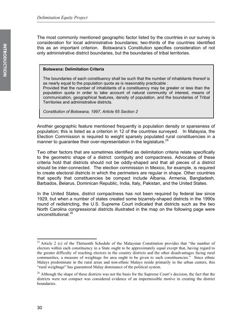
- Page 28 and 29: Introduction: Towards Developing In
- Page 32 and 33: Introduction: Towards Developing In
- Page 34 and 35: Introduction: Towards Developing In
- Page 36 and 37: Introduction: Towards Developing In
- Page 38: Introduction: Towards Developing In
- Page 41 and 42: Delimitation Equity Project Country
- Page 43 and 44: Delimitation Equity Project Country
- Page 45 and 46: Delimitation Equity Project Country
- Page 47 and 48: Delimitation Equity Project Country
- Page 49 and 50: Delimitation Equity Project Country
- Page 51 and 52: Delimitation Equity Project Country
- Page 53 and 54: Delimitation Equity Project Country
- Page 55 and 56: Delimitation Equity Project Country
- Page 57 and 58: Delimitation Equity Project Country
- Page 59 and 60: Delimitation Equity Project Country
- Page 62 and 63: Introduction: Towards Developing In
- Page 64 and 65: Introduction: Towards Developing In
- Page 66 and 67: Introduction: Towards Developing In
- Page 68 and 69: Introduction: Towards Developing In
- Page 70 and 71: Introduction: Towards Developing In
- Page 72 and 73: Introduction: Towards Developing In
- Page 74 and 75: Introduction: Towards Developing In
- Page 76 and 77: Introduction: Towards Developing In
- Page 78 and 79: Introduction: Towards Developing In
- Page 80:
Introduction: Towards Developing In
- Page 83 and 84:
Delimitation Equity Project majorit
- Page 86:
Chapter 2 Chapter 2: Constituency D
- Page 89 and 90:
Delimitation Equity Project The pro
- Page 91 and 92:
Delimitation Equity Project Indepen
- Page 93 and 94:
Delimitation Equity Project Parties
- Page 95 and 96:
Delimitation Equity Project The par
- Page 97 and 98:
Delimitation Equity Project Table 2
- Page 99 and 100:
Delimitation Equity Project constit
- Page 101 and 102:
Delimitation Equity Project geograp
- Page 103 and 104:
Delimitation Equity Project recogni
- Page 105 and 106:
Delimitation Equity Project Constit
- Page 107 and 108:
Delimitation Equity Project Constit
- Page 110:
Chapter 3 Chapter 3: Constituency D
- Page 113 and 114:
Delimitation Equity Project generat
- Page 115 and 116:
Delimitation Equity Project If the
- Page 117 and 118:
Delimitation Equity Project State N
- Page 119 and 120:
Delimitation Equity Project delimit
- Page 121 and 122:
Delimitation Equity Project Few Cle
- Page 123 and 124:
Delimitation Equity Project It may
- Page 125 and 126:
Delimitation Equity Project Difficu
- Page 127 and 128:
Delimitation Equity Project Nationa
- Page 129 and 130:
Delimitation Equity Project The ext
- Page 132:
Chapter 4 Chapter 4: Delimitation E
- Page 135 and 136:
Delimitation Equity Project outcome
- Page 138:
Chapter 5 Chapter 5: Case Study: Af
- Page 141 and 142:
Delimitation Equity Project session
- Page 143 and 144:
Delimitation Equity Project • 12
- Page 145 and 146:
Delimitation Equity Project incenti
- Page 147 and 148:
Delimitation Equity Project the oth
- Page 150 and 151:
Case Studies: Afghanistan Appendix:
- Page 152 and 153:
Case Studies: Afghanistan UNAMA Pro
- Page 154 and 155:
Case Studies: Afghanistan UNAMA Pro
- Page 156 and 157:
Case Studies: Afghanistan UNAMA Pro
- Page 158 and 159:
Case Studies: Afghanistan UNAMA Pro
- Page 160 and 161:
Case Studies: Afghanistan UNAMA Pro
- Page 162 and 163:
Case Studies: Afghanistan UNAMA Pro
- Page 164 and 165:
Case Studies: Afghanistan UNAMA Pro
- Page 166 and 167:
Case Studies: Afghanistan UNAMA Pro
- Page 168 and 169:
Case Studies: Afghanistan UNAMA Pro
- Page 170:
Chapter 6 Chapter 6: Case Study: Au
- Page 173 and 174:
Delimitation Equity Project Of the
- Page 175 and 176:
Delimitation Equity Project After t
- Page 177 and 178:
Delimitation Equity Project suggest
- Page 179 and 180:
Delimitation Equity Project For exa
- Page 182:
Case Studies: Australia Appendix: A
- Page 186:
Case Studies: Australia Appendix C:
- Page 190 and 191:
Case Studies: Democratic Republic o
- Page 192 and 193:
Case Studies: Democratic Republic o
- Page 194 and 195:
Case Studies: Democratic Republic o
- Page 196 and 197:
Case Studies: Democratic Republic o
- Page 198 and 199:
Case Studies: Democratic Republic o
- Page 200 and 201:
Case Studies: Democratic Republic o
- Page 202:
Case Studies: Democratic Republic o
- Page 205 and 206:
Delimitation Equity Project List PR
- Page 207 and 208:
Delimitation Equity Project List PR
- Page 209 and 210:
Delimitation Equity Project List PR
- Page 211 and 212:
Delimitation Equity Project List PR
- Page 213 and 214:
Delimitation Equity Project List PR
- Page 215 and 216:
Delimitation Equity Project List PR
- Page 217 and 218:
Delimitation Equity Project List PR
- Page 219 and 220:
Delimitation Equity Project Mixed M
- Page 221 and 222:
Delimitation Equity Project Mixed M
- Page 223 and 224:
Delimitation Equity Project Mixed M
- Page 225 and 226:
Delimitation Equity Project Mixed M
- Page 228:
Chapter 8 Chapter 8: Case Study: Fi
- Page 231 and 232:
Delimitation Equity Project The 199
- Page 233 and 234:
Delimitation Equity Project inspect
- Page 235 and 236:
Delimitation Equity Project The pop
- Page 237 and 238:
Delimitation Equity Project 1999 Pa
- Page 239 and 240:
Delimitation Equity Project Table 8
- Page 241 and 242:
Delimitation Equity Project Code Co
- Page 244:
Chapter 9 Chapter 9: Case Studies:
- Page 247 and 248:
Delimitation Equity Project The com
- Page 249 and 250:
Delimitation Equity Project 2. The
- Page 251 and 252:
Delimitation Equity Project • Rep
- Page 253 and 254:
Delimitation Equity Project 18 Meck
- Page 255 and 256:
Delimitation Equity Project Ideal S
- Page 257 and 258:
Delimitation Equity Project Ideal S
- Page 259 and 260:
Delimitation Equity Project Ideal S
- Page 261 and 262:
Delimitation Equity Project Ideal S
- Page 264 and 265:
Case Studies: Kosovo Case Study: Ko
- Page 266 and 267:
Case Studies: Kosovo 2. They offer
- Page 268 and 269:
Case Studies: Kosovo pronounced eff
- Page 270 and 271:
Case Studies: Kosovo Delimitation m
- Page 272 and 273:
Case Studies: Kosovo maps. The popu
- Page 274 and 275:
Case Studies: Kosovo the vote count
- Page 276:
Case Studies: Kosovo the vote count
- Page 279 and 280:
Delimitation Equity Project MCODE A
- Page 281 and 282:
Delimitation Equity Project MCODE A
- Page 283 and 284:
Delimitation Equity Project MCODE A
- Page 286 and 287:
Case Studies: Malaysia Case Study:
- Page 288 and 289:
Case Studies: Malaysia 2. No single
- Page 290 and 291:
Case Studies: Malaysia overwhelming
- Page 292:
Case Studies: Malaysia Appendix: Ma
- Page 296:
Case Studies: Malaysia Appendix C:
- Page 300 and 301:
Case Studies: New Zealand Case Stud
- Page 302 and 303:
Case Studies: New Zealand members a
- Page 304 and 305:
Case Studies: New Zealand a large p
- Page 306 and 307:
Case Studies: New Zealand Redistrib
- Page 308 and 309:
Case Studies: New Zealand Conclusio
- Page 310 and 311:
Case Studies: New Zealand Appendix
- Page 312:
Case Studies: New Zealand 311
- Page 315 and 316:
Delimitation Equity Project 314
- Page 318:
Chapter 13 Chapter 13: Case Study:
- Page 321 and 322:
Delimitation Equity Project Revisio
- Page 323 and 324:
Delimitation Equity Project Boundar
- Page 325 and 326:
Delimitation Equity Project with en
- Page 328:
Case Studies: Singapore Appendix: S
- Page 332:
Case Studies: Singapore Appendix C:
- Page 336:
Chapter 14 Chapter 14: Case Study:
- Page 339 and 340:
Delimitation Equity Project Vivian
- Page 341 and 342:
Delimitation Equity Project A legal
- Page 343 and 344:
Delimitation Equity Project (There
- Page 346:
Chapter 15 Chapter 15: Case Study:
- Page 349 and 350:
Delimitation Equity Project Redistr
- Page 351 and 352:
Delimitation Equity Project encoura
- Page 353 and 354:
Delimitation Equity Project State C
- Page 356:
Chapter 16 Chapter 16: Case Study:
- Page 359 and 360:
Delimitation Equity Project Yemeni
- Page 361 and 362:
Delimitation Equity Project The 5,6
- Page 363 and 364:
Delimitation Equity Project • pro
- Page 365 and 366:
Delimitation Equity Project Advanta
- Page 367 and 368:
Delimitation Equity Project Conclus
- Page 370:
Case Studies: Yemen Appendix: Yemen
- Page 374:
Chapter 17 Chapter 17: Observing De
- Page 377 and 378:
Delimitation Equity Project The sec
- Page 379 and 380:
Delimitation Equity Project the bou
- Page 381 and 382:
Delimitation Equity Project The del
- Page 383 and 384:
Delimitation Equity Project Figure1
- Page 385 and 386:
Delimitation Equity Project proof o
- Page 387 and 388:
Delimitation Equity Project A class
- Page 389 and 390:
Delimitation Equity Project difficu
- Page 391 and 392:
Delimitation Equity Project In some
- Page 393 and 394:
Delimitation Equity Project It shou
- Page 395 and 396:
Delimitation Equity Project commiss
- Page 398 and 399:
Observing Delimitation Appendices:
- Page 400:
Observing Delimitation • Has geog
- Page 403 and 404:
Delimitation Equity Project tending
- Page 405 and 406:
Delimitation Equity Project In the