trail and access road - Central Federal Lands Highway Division
trail and access road - Central Federal Lands Highway Division
trail and access road - Central Federal Lands Highway Division

Create successful ePaper yourself
Turn your PDF publications into a flip-book with our unique Google optimized e-Paper software.
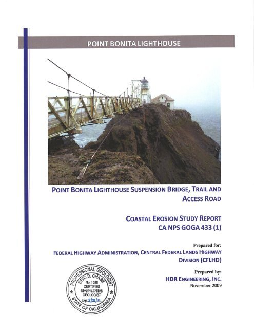
Coastal Erosion Study Report<br />
Point Bonita Lighthouse Suspension Bridge, Trail <strong>and</strong> Access Road<br />
1.0 INTRODUCTION<br />
This report summarizes the findings of a reconnaissance study of geologic conditions <strong>and</strong> the<br />
potential for continued coastal erosion at the site of the Point Bonita Lighthouse Bridge in the<br />
Golden Gate National Recreation Area north of San Francisco, California (see Figure 1 below).<br />
This work is being conducted for the <strong>Federal</strong> <strong>Highway</strong> Administration, <strong>Central</strong> <strong>Federal</strong> L<strong>and</strong>s<br />
<strong>Highway</strong> <strong>Division</strong> (CFLHD), CA NPS GOGA 433(1), under Task Order DTFH68-06-D-<br />
00007/T-09-014.<br />
As outlined in the task order proposal, the purpose of the geologic <strong>and</strong> erosion assessment was<br />
defined with the following goals:<br />
“The work is a preliminary screening study, of both coastal erosion <strong>and</strong> foundation rockmass<br />
slope stability hazards potentially affecting the planned service life of the proposed replacement<br />
bridge, including a cursory, qualitative review of site conditions with respect to overall stability<br />
of the proposed replacement bridge foundations <strong>and</strong> underlying rockmass, with the objective of<br />
identifying specific site conditions (potential fatal flaws) that may require additional evaluation<br />
in future work. Whether or not potential fatal flaws are identified, modes of failure of the<br />
foundation rockmass, if apparent, <strong>and</strong> feasible mitigation alternatives will be identified. The<br />
modes of unsatisfactory performance of the rockmass may be grouped into three major<br />
categories: (1) Erosion of the lower portions of the rockmass leading to undermining <strong>and</strong><br />
instability of the overlying portions (structure foundation portion) of the rockmass; (2) Static<br />
stability of the upper portions of the rockmass separate from erosion of the lower portions of<br />
the rockmass, <strong>and</strong> (3) Qualitative predictions of site stability under a seismic event.”<br />
In addition to the scope described in the Task Order, at the request of the National Park<br />
Service, additional field observations were made, photographs were taken, <strong>and</strong> a review of<br />
previous monitoring data was completed for the <strong>trail</strong> leading from the southerly tunnel portal to<br />
the northeasterly bridge abutment, <strong>and</strong> for the <strong>access</strong> <strong>road</strong> from Conzelman Road to the<br />
northerly tunnel portal (see Photo 1 below).<br />
1 November 2009
Coastal Erosion Study Report<br />
Point Bonita Lighthouse Suspension Bridge, Trail <strong>and</strong> Access Road<br />
Photo 1. Overview of Point Bonita site showing features.<br />
2 November 2009
Coastal Erosion Study Report<br />
Point Bonita Lighthouse Suspension Bridge, Trail <strong>and</strong> Access Road<br />
2.0 BACKGROUND<br />
The historic Point Bonita Lighthouse Bridge is located within the Golden Gate National<br />
Recreation Area (GGNRA) in Marin County, CA, just northwest of the Golden Gate Bridge,<br />
<strong>and</strong> provides <strong>access</strong> to a lighthouse operated by the United States Coast Guard.<br />
Figure 1. Vicinity Map<br />
The bridge was inspected under the National Bridge Inventory System’s (NBIS) Bridge<br />
Inspection Program (BIP) by the <strong>Federal</strong> L<strong>and</strong>s Bridge Office in September, 2007. The bridge<br />
inspection report was completed <strong>and</strong> distributed in October, 2007. The report found the bridge<br />
to be severely corroded <strong>and</strong> in poor overall condition. Based on the deteriorated condition, the<br />
bridge is currently load rated for a “two person” limit. The 2007 inspection report<br />
recommended that the structure be replaced within the next two to three years due to the<br />
advanced state of deterioration <strong>and</strong> the dangerous site conditions.<br />
A draft Bridge Selection Report has recently been completed by HDR Engineering, Inc. That<br />
report provides recommendations for a replacement bridge <strong>and</strong> includes a conceptual design.<br />
3 November 2009
Coastal Erosion Study Report<br />
Point Bonita Lighthouse Suspension Bridge, Trail <strong>and</strong> Access Road<br />
The report further recommends that a study be undertaken to determine the potential for further<br />
cliff erosion that could impact the stability of the proposed new bridge.<br />
4 November 2009
Coastal Erosion Study Report<br />
Point Bonita Lighthouse Suspension Bridge, Trail <strong>and</strong> Access Road<br />
3.0 FIELD REVIEW SITE VISIT<br />
Eric Chase, P.G., C.E.G., <strong>and</strong> Joel Darnell, Coastal Engineer, both of HDR Engineering, Inc.<br />
conducted the Field Review Site Visit. The objective of the field review was to document the<br />
existing geologic conditions around the suspension bridge <strong>and</strong> along the lower portions of the<br />
bluffs supporting the bridge.<br />
The sideslopes at the site are very rugged, <strong>and</strong> close observation of the sideslopes of Point<br />
Bonita was not performed due to the oversteepened slopes adjacent to the <strong>trail</strong>. These<br />
observations could be performed using proper rock climbing techniques <strong>and</strong> equipment;<br />
however this approach was outside of the scope of this study. Data obtained during the field<br />
visit was limited to observations of slopes <strong>and</strong> erosion conditions from available viewpoints on<br />
the mainl<strong>and</strong> <strong>and</strong> from the path <strong>and</strong> bridge. Subsurface investigations were not performed.<br />
The specific field activities conducted during the field visit included the following:<br />
• Available literature including published geologic maps <strong>and</strong> reports, unpublished<br />
consulting reports, <strong>trail</strong> monitoring data, <strong>and</strong> aerial photographs were obtained <strong>and</strong><br />
reviewed.<br />
• Available photos <strong>and</strong> reports from the literature review were brought to the field for<br />
reference. Ocean conditions were visually observed, including wave diffraction <strong>and</strong><br />
shoaling, ocean conditions along exposed slopes, <strong>and</strong> evidence of wave-induced erosion<br />
<strong>and</strong> failure within project bounds.<br />
• Digital photographs were taken of features considered relevant to evaluating current<br />
geological conditions affecting support for the existing bridge. Photographs were taken<br />
of the rockmass supporting the bridge abutments <strong>and</strong> of the underlying slope to ocean<br />
level. Photographs were taken only from safe vantage points on the adjoining portions<br />
of the Point.<br />
• Significant through-going planes of weakness in the diabasic <strong>and</strong> basaltic rocks were<br />
recorded in the field on a Light Detection <strong>and</strong> Ranging (LIDAR)-derived topographic<br />
5 November 2009
Coastal Erosion Study Report<br />
Point Bonita Lighthouse Suspension Bridge, Trail <strong>and</strong> Access Road<br />
base map. A preliminary geologic map was prepared showing visually-observable<br />
rockmass slope features. Selected features were photographed <strong>and</strong> the photos labeled<br />
(see photos herein <strong>and</strong> Preliminary Geologic Map, Attachment 1). The reconnaissance<br />
focused on evidence of past rock slope failures <strong>and</strong> continuous rockmass discontinuities<br />
oriented so as to define blocks, wedges, or sheets that are potentially free to move out of<br />
the rockmass, <strong>and</strong> which could lead to loss of bridge abutment foundation support.<br />
• Where <strong>access</strong>ible without safety equipment, surface geologic data was mapped <strong>and</strong><br />
measured, including rock type, degree of weathering, <strong>and</strong> fracture, shear zone <strong>and</strong> joint<br />
orientation, spacing, continuity, openness, <strong>and</strong> infilling. The data were subsequently<br />
transferred to photographs of those portions of the site.<br />
6 November 2009
Coastal Erosion Study Report<br />
Point Bonita Lighthouse Suspension Bridge, Trail <strong>and</strong> Access Road<br />
4.0 OBSERVATIONS AND DISCUSSION<br />
On May 27, 2009 Messrs. Chase <strong>and</strong> Darnell of HDR met with John Ryan of the National Park<br />
Service (NPS) to perform an engineering geology <strong>and</strong> coastal erosion reconnaissance<br />
assessment of the Point Bonita Lighthouse area. The original scope included only the bridge<br />
abutments <strong>and</strong> areas immediately adjacent to the bridge. However, Mr. Ryan requested that the<br />
reconnaissance be exp<strong>and</strong>ed to include the <strong>access</strong> <strong>road</strong>, tunnel, <strong>and</strong> <strong>trail</strong> areas. Mr. Ryan<br />
indicated areas of concern relative to slope stability <strong>and</strong> erosion based on his long tenure <strong>and</strong><br />
experience at the site, which encompasses the past 30 years. Mr. Ryan has documented the<br />
erosion at various places along both the <strong>access</strong> <strong>road</strong> <strong>and</strong> <strong>trail</strong>, as well as various failures in the<br />
rock mass supporting the southwesterly bridge abutment (see comparison of 1980 <strong>and</strong> 2009<br />
conditions in Photo 4 below).<br />
Based on available published <strong>and</strong> unpublished geologic reports <strong>and</strong> maps <strong>and</strong> observations<br />
during the site reconnaissance, the geology of the site consists of a basement complex of<br />
greenstone comprising metamorphosed diabase, metamorphosed basalt flows <strong>and</strong><br />
metamorphosed pillow basalts (Blake et al., 1985, William Lettis <strong>and</strong> Associates, 1994,<br />
Schlocker, J. et al., 1958, <strong>and</strong> Schlocker, 1974). These bedrock units are locally overlain by<br />
surficial deposits including talus, l<strong>and</strong>slide debris, marine terrace deposits, <strong>and</strong> residual soils<br />
(colluvium). Site geology is presented on the Preliminary Geologic Map, Attachment 1.<br />
4.1 Geologic Conditions - Suspension Bridge Area<br />
As described above, the suspension bridge area is underlain by metamorphosed diabase,<br />
metamorphosed basalt, <strong>and</strong> metamorphosed pillow basalt. Numerous steeply-inclined<br />
intersecting planes of weakness are evident in the rocks immediately beneath the<br />
suspension bridge, as depicted in Photos 2 through 4 <strong>and</strong> on Attachment 1, Preliminary<br />
Geologic Map. These planes of weakness reflect tectonic stresses applied to the rock<br />
both during metamorphism <strong>and</strong> subsequent tectonic translocation from west to east<br />
during obduction. Further planes of weakness may have formed due to seismic shaking<br />
<strong>and</strong> gravity-induced rock creep.<br />
7 November 2009
Coastal Erosion Study Report<br />
Point Bonita Lighthouse Suspension Bridge, Trail <strong>and</strong> Access Road<br />
Mr. Ryan indicated that the rock surface beneath the southwesterly bridge abutment has<br />
been noticeably eroding, <strong>and</strong> he recalled that the rock at abutment level was nominally<br />
six feet wider as recently as 15 years ago. Evidence of historic <strong>and</strong> recent slope failures<br />
in the middle <strong>and</strong> lower bluffs can be seen in the following photos. The scar from a<br />
1937 slope failure event (documented in historic photographs <strong>and</strong> records provided by<br />
the United States Coast Guard <strong>and</strong> NPS) is evident in Photo 1 below (view to<br />
northwest). Evidence of significant further erosion since the 1937 rockfall event is<br />
visible by comparison of Photo 2 (1937) with Photo 3 (2009).<br />
Photo 2.<br />
Northwesterly view of south side of Point, circa. 1937, showing<br />
failure of l<strong>and</strong> bridge to lighthouse.<br />
8 November 2009
Coastal Erosion Study Report<br />
Point Bonita Lighthouse Suspension Bridge, Trail <strong>and</strong> Access Road<br />
Photo 3.<br />
Northwesterly view of south side of Point, 2009, with scar of 1937 rock<br />
failure faintly visble. Note that the bridge construction was necessitated<br />
by failure of the l<strong>and</strong> bridge to the lighthouse. Diabase forms the cliff<br />
face with pillow basalt exposed at the base near the water line.<br />
9 November 2009
Coastal Erosion Study Report<br />
Point Bonita Lighthouse Suspension Bridge, Trail <strong>and</strong> Access Road<br />
Photo 4.<br />
Comparison of 2009 western abutment slope below suspension bridge<br />
with 1980 slope face. Note block which appears to have failed within<br />
circled area.<br />
Through-going planes of weakness (joints <strong>and</strong> shear zones) are well-exposed beneath<br />
the bridge <strong>and</strong> offer insight into the previous mechanisms of local failure. Steeplyinclined<br />
shear zones have formed the roughly planar surfaces along which the failures<br />
have released (see 2009 photograph above). Numerous intersecting joints, fractures,<br />
<strong>and</strong> shear zones are visible to the left of the recently-failed area, some of which are<br />
sufficiently through-going to jeopardize the stability of larger blocks of diabase, which<br />
will likely be next to fail. The most persistent of these weakness planes are depicted on<br />
Attachment 1.<br />
Wave erosion is evident as visible undermining at the water line. Two arches <strong>and</strong> a sea<br />
cave were noted in the reconnaissance (see Attachment 1), providing further evidence<br />
of active erosional processes within the wave impact zone.<br />
10 November 2009
4.2 Geologic Conditions Findings<br />
Coastal Erosion Study Report<br />
Point Bonita Lighthouse Suspension Bridge, Trail <strong>and</strong> Access Road<br />
This section is intended to address Items 2 <strong>and</strong> 3 from the task order proposal, outlined<br />
in Section 1 of this report <strong>and</strong> re-stated here:<br />
(2) Static stability of the upper portions of the rockmass separate from<br />
erosion of the lower portions of the rockmass, <strong>and</strong><br />
(3) Qualitative predictions of site stability under a seismic event.<br />
The static stability of the upper rockmass appears to be highly variable from location to<br />
location. As observed during the site visit, the rock is highly to moderately fractured,<br />
highly to moderately weathered, <strong>and</strong> is overlain by a variable but generally thin veneer<br />
of residual soils <strong>and</strong> colluvium. Significant <strong>and</strong> geologically rapid degradation of the<br />
rockmass on which the bridge is founded has occurred in the past 80 years <strong>and</strong> will<br />
likely continue. Such degradation may directly influence the stability of the bridge<br />
foundations (see Photo 4 above). Due to the oversteepened nature of all the sideslopes<br />
at the site, the continuous undercutting of the lower basaltic <strong>and</strong> diabasic units by wave<br />
action cannot be discounted in a qualitative evaluation of slope stability. Observations<br />
indicate that portions of the slopes are at or near instability (safety factor approaching<br />
1.0) <strong>and</strong> may be subject to localized or significant failure, especially during a seismic<br />
event. A quantitative estimate of the likelihood or significance of these potential<br />
failures was not included within the scope of this limited study.<br />
4.3 Coastal Erosion<br />
4.3.1 Site Conditions<br />
Wave conditions on May 27, 2009 were typical for the month of May, with 4- to<br />
6-foot swells from the southwest at periods of 8 to 10 seconds (National Data<br />
Buoy Center - Station 46237). Winds were moderate at 15 to 20 knots. Wave<br />
action increased slightly in the afternoon. The tide rose from about -2 ft relative<br />
to North American Vertical Datum (NAVD) 88 up to about +5 ft relative to<br />
NAVD88 at high tide (National Oceanographic <strong>and</strong> Atmospheric Administration<br />
- Station 9414290).<br />
11 November 2009
Coastal Erosion Study Report<br />
Point Bonita Lighthouse Suspension Bridge, Trail <strong>and</strong> Access Road<br />
4.3.2 Observations<br />
North-facing rock bluffs are directly exposed to Pacific Ocean swell. Near the<br />
water line, ongoing wave undercutting of the bluff face is evident. Active wave<br />
erosion appears to cease approximately 20 feet above mean higher high water.<br />
Talus, consisting primarily of diabase blocks, appears to provide some natural<br />
armoring at the base of the bluff. This armoring is probably only effective<br />
during relatively calm to moderate wave action. Much of the material at the<br />
base of the bluff has been broken <strong>and</strong> repeatedly reworked by waves <strong>and</strong><br />
currents into boulders <strong>and</strong> large cobbles. Cobbles have accumulated in the<br />
sheltered areas at the foot of southerly-facing bluffs.<br />
Erosion <strong>and</strong> slides of loose s<strong>and</strong>y material <strong>and</strong> weathered rock contribute some<br />
s<strong>and</strong> <strong>and</strong> gravel to the beach that fronts the west-facing side of the headl<strong>and</strong>. In<br />
such a high-energy wave environment, little of these materials remains in the<br />
intertidal zone, either being buried beneath larger cobble or transported offshore<br />
<strong>and</strong> deposited in deeper water following large storms.<br />
Wave-induced erosion near the water line appears to be a relatively slow<br />
process, based on comparison of historical <strong>and</strong> current photographs. Exposed<br />
pillow basalt formations near the water line formed slopes from nearly-vertical<br />
to undercut due to weathering by seawater <strong>and</strong> erosion from constant wave<br />
action. The foundation of the existing southwesterly bridge tower appeared<br />
vulnerable to long term erosion <strong>and</strong> undermining of the rock face by wave<br />
action. At this location, the rock face is nearly vertical <strong>and</strong> appears to extend<br />
from the tower footing to the water line. The northeasterly bridge tower<br />
foundation is less vulnerable to erosive wave action, being located away from<br />
the exposed rock face.<br />
On the east-facing side of Point Bonita, wave action is significantly reduced as<br />
evidenced by s<strong>and</strong>y pocket beaches. Weathering <strong>and</strong> undercutting was observed<br />
near the water line. Slopes near the water line are generally less steep in these<br />
12 November 2009
Coastal Erosion Study Report<br />
Point Bonita Lighthouse Suspension Bridge, Trail <strong>and</strong> Access Road<br />
areas. Wave action does not appear to be contributing to the surface erosion<br />
occurring near the northeast anchor block.<br />
4.4 Coastal Erosion Findings<br />
This section is intended to address Item 1 from the task order proposal, re-stated as:<br />
(1) Erosion of the lower portions of the rockmass leading to undermining <strong>and</strong><br />
instability of the overlying portions (structure foundation portion) of the<br />
rockmass;<br />
Our observations related to erosion <strong>and</strong> undermining of the bluffs at Point Bonita include<br />
the following.<br />
• Wave <strong>and</strong> tidal action are actively eroding <strong>and</strong> weathering the base of the bluffs <strong>and</strong><br />
rock faces at Point Bonita, particularly on the west side.<br />
• Existing talus provides some natural armoring at the base of the west-facing bluffs,<br />
likely reducing erosion rates near the water line. The talus appears to provide<br />
protection during low to moderate energy wave events, but is unlikely to protect the<br />
bluffs during high wave periods.<br />
• Placement of armoring material such as large natural rock to protect the base of the<br />
bluffs is unlikely to be effective in mitigating bluff erosion <strong>and</strong> retreat since some<br />
natural armoring is already in place. Upper bluff weathering will continue to occur,<br />
even if the effects of wave action are mitigated at the base of the bluff.<br />
13 November 2009
Coastal Erosion Study Report<br />
Point Bonita Lighthouse Suspension Bridge, Trail <strong>and</strong> Access Road<br />
5.0 NOTES ON GEOLOGIC INSPECTION - TRAIL AND<br />
ACCESS ROAD<br />
5.1 Trail<br />
Two pre-fabricated fiberglass bridges, one approximately 40 feet long <strong>and</strong> the other<br />
approximately 80 feet long, have been placed along the <strong>trail</strong> where on-going erosion<br />
<strong>and</strong> sloughing have compromised the structural integrity <strong>and</strong> safety of the path. Mr.<br />
Ryan indicated these bridges were installed more than 10 years ago. Mr. Ryan also<br />
indicated that these footbridge locations are areas of continuing concern from a<br />
maintenance perspective. An additional area with evidence of downslope creep <strong>and</strong><br />
potential sloughing is found along the <strong>trail</strong> between 230 <strong>and</strong> 290 feet west of the west<br />
tunnel portal.<br />
At this location the concrete <strong>trail</strong> pavement is cracked <strong>and</strong> shows<br />
evidence of subsidence attributable to downslope creep of surficial soil <strong>and</strong> weathered<br />
rock on which the <strong>trail</strong> pavement is founded.<br />
In 1996 a number of survey monuments were installed to monitor movement of the<br />
ground surface along the <strong>trail</strong> by William Lettis <strong>and</strong> Associates, Inc. (WLA). A h<strong>and</strong><br />
drawn WLA map, comprising two sheets <strong>and</strong> labeled WLA Figure 1, Appendix C is<br />
provided as Attachment 2 hereto. This map illustrates the locations of the <strong>trail</strong><br />
monitoring points discussed below. Measurement data recorded by NPS personnel<br />
from 1996 through 2003 were provided by John Ryan <strong>and</strong> were reviewed. The<br />
measurements consisted of recording the distance between two fixed points at each<br />
station. The fixed points included brass survey markers, concrete nails, or steel rebar<br />
driven into the ground. The initial <strong>and</strong> final readings of the distances between the two<br />
points for each station, <strong>and</strong> the corresponding movement rates for each station along the<br />
<strong>trail</strong> are presented in Table 1:<br />
14 November 2009
Coastal Erosion Study Report<br />
Point Bonita Lighthouse Suspension Bridge, Trail <strong>and</strong> Access Road<br />
Table 1. Measurements of Trail Monitoring Stations 1996-2003<br />
Rate of<br />
Change<br />
(inches per<br />
month)<br />
Measurement<br />
Point<br />
Initial<br />
Reading<br />
(Date)<br />
Final<br />
Reading<br />
(Date)<br />
Net<br />
Displacement<br />
TMS-1 63” (6-17-96) 64 ½” (3-5-99) 1 ½” 0.045<br />
TMS-2 5 ⅛” (6-17-96) 5 7/8” (12-16-03) 3/4” 0.008<br />
TMS-3 70” (6-17-96) 70 7/8” (12-16- 7/8” 0.010<br />
03)<br />
TMS-4 3” (6-17-96) 2 15/16” (7-13- -1/16” 0.0007<br />
03)<br />
TMS-5 37” (6-17-96) 36 3/4” (12-16- -3/4” -0.008<br />
03)<br />
TMS-6 49 ¼” (6-17- 49” (12-16-03) -1/4” 0.003<br />
96)<br />
TMS-7 41 ½” (6-17- 41 3/4” (12-16- 1/4” 0.003<br />
96)<br />
03)<br />
TMS-8 51 ½” (6-17- 51 ½” (12-16-03) No Change 0.000<br />
96)<br />
TMS-9 None None N/A ---<br />
TMS-10 95 ¾” (6-17- 96” (7-13-03) 1/4” 0.003<br />
96)<br />
TMS-11 21 ½” (6-17- 21 ¼” (12-16-03) -1/4” 0.003<br />
96)<br />
TMS-12 68 ½” (6-17- 68 ½” (12-16-03) No Change 0.000<br />
96)<br />
TMS-13 None None N/A ---<br />
TMS-14 31 3/8” (6-17- 31” (12-16-01) -3/8” 0.006<br />
96)<br />
TMS-15 None None N/A ---<br />
TMS-16 None None N/A ---<br />
No measurements were recorded for three of the sixteen total stations. The recorded<br />
target accuracy of measurement (+/- 0.125” to 0.25”) was higher than the measured<br />
value of net change for all but five of the 13 measured stations. The five stations for<br />
which the data are therefore considered reliable include TMS-1, -2, -3, -5, <strong>and</strong> -14. Of<br />
these five stations, three had measured spacings that became wider <strong>and</strong> two had<br />
measured spacings that became smaller.<br />
15 November 2009
Coastal Erosion Study Report<br />
Point Bonita Lighthouse Suspension Bridge, Trail <strong>and</strong> Access Road<br />
Examination of the descriptions <strong>and</strong> photographs included with the NPS records also<br />
provides insight into the nature of the movements recorded for the five stations with<br />
reliable data, as follows.<br />
Station TMS-1: The horizontal distance between two steel rebar pins with yellow<br />
protective caps on either side of the <strong>trail</strong> was measured. The <strong>trail</strong> in this location spans<br />
the head of a shallow colluvium-filled swale, which in 1996 experienced several inches<br />
of settlement (labeled Slide Area 1 on the attached WLA map, Attachment 2). The<br />
monitoring data indicate that this section has settled an additional 1½ inches from 1996-<br />
1999, <strong>and</strong> may need to be stabilized to keep the <strong>trail</strong> open to foot traffic.<br />
Station TMS-2: Two nails set in the paved surface of the <strong>trail</strong> were measured for their<br />
horizontal separation. The nails have separated by ¾-inch over a 7½-year period,<br />
indicating lateral spreading due to slow downslope creep of the underlying surface.<br />
TMS-2 is located at the head of a second colluvium-filled swale (labeled Slide Area 2<br />
on Attachment 2). This area may need to be stabilized to keep the <strong>trail</strong> open to foot<br />
traffic.<br />
Station TMS-3: The horizontal distance between a brass survey marker <strong>and</strong> a piece of<br />
rebar set on the western (upslope) edge of the <strong>trail</strong> pavement was measured. The<br />
readings indicate that the distance has increased by 7/8-inch over a 7½-year period.<br />
TMS-3 is located very near to TMS-2 in the same colluvium-filled swale (Slide Area 2).<br />
This area may need to be stabilized to keep the <strong>trail</strong> open to foot traffic.<br />
Station TMS-5: This station comprises a yellow-capped reinforcing bar driven into the<br />
ground on the downslope edge of the <strong>trail</strong> <strong>and</strong> a nail located on the upslope (western)<br />
edge of the <strong>trail</strong> pavement. This station is located on the southerly edge of the head of<br />
the colluvium-filled swale in which TMS-2 <strong>and</strong> -3 are located. The horizontal distance<br />
between the rebar <strong>and</strong> the nail decreased by ¾-inch in a 7½-year monitoring period.<br />
This may be attributable to headward rotation of the rebar due to downslope creep of<br />
the colluvium, but vertical measurements that would either confirm or preclude this<br />
possibility were not obtained. This area may need to be stabilized to keep the <strong>trail</strong> open<br />
to foot traffic.<br />
16 November 2009
Coastal Erosion Study Report<br />
Point Bonita Lighthouse Suspension Bridge, Trail <strong>and</strong> Access Road<br />
Station TMS-14: This station comprises a yellow-capped reinforcing bar driven into<br />
the ground on the downslope side of the 80-foot long fiberglass bridge <strong>and</strong> a brass<br />
survey marker set in the foundation of the bridge. The horizontal distance between the<br />
rebar <strong>and</strong> the bridge foundation decreased by 3/8-inch in a 5½-year monitoring period.<br />
This may also be attributable to headward rotation of the rebar due to downslope creep<br />
of the colluvium, but no vertical measurements were obtained that would help to<br />
confirm or preclude this possibility.<br />
In summary, measurements at 13 <strong>trail</strong> monitoring stations over a period of 5½ to 7½<br />
years indicate that continuing downslope creep of surficial soil on which the <strong>trail</strong> was<br />
constructed may be ongoing at three locations, namely Slide Areas 1 <strong>and</strong> 2 <strong>and</strong> the<br />
downslope side of the southerly edge of the long, pre-fabricated fiberglass bridge. All<br />
these locations were identified by WLA as being surficially unstable in 1996. The two<br />
fiberglass bridges now in use were reportedly installed in areas of recognized erosion,<br />
creep, or settlement <strong>and</strong> thus provide a biased record of the overall <strong>trail</strong> stability. These<br />
areas continue to degrade due to natural erosion processes. Measurements recorded at<br />
ten other monitoring stations were inconclusive relative to the expressed target accuracy<br />
associated with the measurement methods employed by NPS personnel.<br />
5.2 Access Road<br />
The <strong>access</strong> <strong>road</strong> extends northerly from the northeast tunnel portal to the pipe gate at<br />
Conzelman Road. The <strong>road</strong> traverses slope areas above three active l<strong>and</strong>slides. The<br />
northernmost slide area does not directly impinge on the <strong>road</strong> alignment, but occupies a<br />
canyon head between a former housing area <strong>and</strong> the <strong>access</strong> <strong>road</strong>. This slide appears to<br />
have destroyed a paved <strong>access</strong> <strong>road</strong> that formerly led to the housing area.<br />
Debris from the middle slide rests in a steep <strong>and</strong> relatively narrow drainage. The <strong>access</strong><br />
<strong>road</strong> traverses the headscarp area of this shallow failure. Two very old <strong>and</strong> rusted<br />
corrugated metal culvert pipes were observed jutting out from beneath the <strong>access</strong> <strong>road</strong>.<br />
The culverts collect water from inlets on <strong>and</strong> above the <strong>access</strong> <strong>road</strong> <strong>and</strong> discharge into<br />
17 November 2009
Coastal Erosion Study Report<br />
Point Bonita Lighthouse Suspension Bridge, Trail <strong>and</strong> Access Road<br />
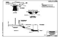
the drainage/middle slide area (see Photo 5 below). Discharge from these drainage<br />
pipes may have contributed to recent reactivation of the upper portion of the slide mass,<br />
which now threatens the <strong>road</strong> shoulder. This area is in need of immediate drainage<br />
modification <strong>and</strong> <strong>road</strong> shoulder reconstruction in order to maintain vehicular <strong>access</strong>.<br />
Photo 5.<br />
Corrugated metal pipes, erosion <strong>and</strong> undermining<br />
of shoulder along <strong>access</strong> <strong>road</strong> (middle slide area).<br />
The southernmost slide area is situated on the east side of a bridge approximately 250<br />
feet uphill of the north tunnel portal (see Photo 6 below). The bridge appears to have<br />
been constructed to mitigate instability caused by headward migration of the failure<br />
scarp that had previously undermined the paved <strong>access</strong> <strong>road</strong>. It appears that erosion of<br />
headscarp materials is progressing on the eastern side.<br />
18 November 2009
Coastal Erosion Study Report<br />
Point Bonita Lighthouse Suspension Bridge, Trail <strong>and</strong> Access Road<br />
Photo 6. Bridge along <strong>access</strong> <strong>road</strong> spanning southernmost l<strong>and</strong>slide escarpment.<br />
Erosional undermining is also progressing toward this bridge location from the western<br />
side. This western side erosion has been treated with a timber crib wall (see Photo 7<br />
below), which shows evidence of undermining since emplacement (date unknown).<br />
Photo 7.<br />
Timber crib wall beneath western side of bridge along <strong>access</strong> <strong>road</strong>.<br />
Note erosional undermining at base of crib wall <strong>and</strong> accumulation of<br />
eroded material on upper cross member.<br />
19 November 2009
Coastal Erosion Study Report<br />
Point Bonita Lighthouse Suspension Bridge, Trail <strong>and</strong> Access Road<br />
6.0 SUMMARY OF FINDINGS<br />
6.1 Suspension Bridge Area<br />
Observations of conditions surrounding the suspension bridge to the Point Bonita Lighthouse<br />
indicate active wave attack at the base of the rock bluffs on which the bridge is founded.<br />
Comparison of current conditions, documented in photographs, with archival photographs<br />
obtained from NPS, along with personal communications with Mr. Ryan regarding his<br />
observations over a 30-year period, indicates retreat rates at the bluff top of up to five inches<br />
per year. Photographic evidence indicates active <strong>and</strong> significant erosion over the past 80 years<br />
of the rock mass upon which the bridge is founded. For rocks of this type under wave attack<br />
<strong>and</strong> weathering processes, the retreat is typically characterized by episodic, sudden rockfall<br />
events that are variable in size. Accurate predictions of conditions at a future point in time are<br />
difficult. Placement of appropriately-sized rock armoring such as rip-rap at the base of the<br />
bluffs on which the bridge, lighthouse, <strong>and</strong> attendant structures are constructed may help to<br />
slow the rate of erosion <strong>and</strong> episodic failure of rock masses in the area, but will not mitigate<br />
seismically-induced failures or failures induced by factors such as weathering <strong>and</strong> frost<br />
wedging. Placement of rip-rap may not be aesthetically acceptable due to alteration of the<br />
viewscape on the scenic headl<strong>and</strong>.<br />
The bridge abutments appear to be anchored into the rock to a depth of approximately six feet.<br />
The southwesterly bridge abutment is in greater jeopardy of being weakened than the<br />
northeasterly abutment, but both abutment areas are considered highly susceptible to rockfalltype<br />
failure events that could compromise the future integrity of the abutments <strong>and</strong> the<br />
functioning of the bridge. The potential for local <strong>and</strong> significant failure during a seismic event<br />
appears to be moderate to high.<br />
6.2 Trail Area<br />
Based on field observations <strong>and</strong> eyewitness accounts, four areas along the <strong>trail</strong> from the tunnel<br />
to the northeasterly suspension bridge abutment, including the two pre-fabricated fiberglass<br />
bridge locations <strong>and</strong> Slide Areas 1 <strong>and</strong> 2, continue to be the critical areas from a maintenance<br />
20 November 2009
Coastal Erosion Study Report<br />
Point Bonita Lighthouse Suspension Bridge, Trail <strong>and</strong> Access Road<br />
st<strong>and</strong>point. The bridges, installed over ten years ago, span areas of erosional narrowing of the<br />
ridge top that have subsequently progressed, according to eyewitness accounts (J. Ryan, 2009,<br />
personal communication). Retreat rates in weathered rock <strong>and</strong> minor soil at these locations are<br />
similarly estimated at a rate of five inches per year per based on observations <strong>and</strong> discussions<br />
with Mr. Ryan. Erosional undermining <strong>and</strong> downslope creep beneath <strong>and</strong> below the foot path<br />
in Slide Areas 1 <strong>and</strong> 2 have caused continuing subsidence <strong>and</strong> cracking of old concrete <strong>and</strong><br />
asphalt pavement in those locations. These <strong>trail</strong> areas will require further stabilization in order<br />
to keep the <strong>trail</strong> open <strong>and</strong> safe for pedestrian use. Although the net lateral displacement of the<br />
<strong>trail</strong> monitoring stations is generally less than or equal to 1.5 inches over the past decade or so,<br />
without further mitigation efforts a sudden failure of many tens of feet of <strong>trail</strong> is possible in any<br />
given winter rainfall event. Such mitigation efforts can include the installation of pipe <strong>and</strong><br />
batter-boards, precast concrete crib walls, or more robust methods such as a micropile wall,<br />
soldier piles <strong>and</strong> lagging or mechanically-stabilized earth wall, depending on the steepness of<br />
the adjacent <strong>and</strong> underlying slopes, the extent <strong>and</strong> thickness of the unstable materials, the<br />
tributary runoff surface area above the <strong>trail</strong> at each location, <strong>and</strong> <strong>access</strong> constraints.<br />
6.3 Access Road Area<br />
The <strong>access</strong> <strong>road</strong> from Conzelman Road to the northeast tunnel portal crosses three l<strong>and</strong>slide<br />
areas. These slides appear to be active, based upon escarpment morphologies, local evidence<br />
of recent erosion, <strong>and</strong> eyewitness accounts. Of greatest concern is the area where the <strong>road</strong><br />
transects the escarpment of the middle slide. Discharge from drainage pipes may have<br />
exacerbated the rate of failure in this area. The shoulder of the <strong>road</strong> is undermined <strong>and</strong> the<br />
pavement is cracking, in part due to root wedging from adjacent trees, but also in part due to<br />
subsidence related to loss of lateral support. This area may require immediate attention to<br />
maintain vehicular <strong>access</strong>. Mitigation of instability in this area might involve construction of a<br />
mechanically-stabilized earth wall, rock-filled gabions, soldier piles, secant wall, or other<br />
methods in conjunction with drainage redirection <strong>and</strong> control, <strong>and</strong> mitigation of erosion in the<br />
surrounding slope areas.<br />
Also of concern is the prefabricated bridge area across the escarpment of the southernmost<br />
slide, which is being undermined by erosion from both sides of the ridgeline. The rate of<br />
21 November 2009
Coastal Erosion Study Report<br />
Point Bonita Lighthouse Suspension Bridge, Trail <strong>and</strong> Access Road<br />
erosion at this location, as reported by eyewitnesses, is such that the approaches to the bridge<br />
<strong>and</strong> perhaps the bridge itself may be sufficiently destabilized in the near future to preclude<br />
vehicle passage. It is likely that this bridge will need to be replaced in the next few years. The<br />
replacement bridge will need to be founded on rock materials at sufficient depth to preclude<br />
destabilization due to l<strong>and</strong>sliding. Design of the replacement bridge will require a geotechnical<br />
investigation of the extent <strong>and</strong> cause(s) of the present ground instability.<br />
22 November 2009
Coastal Erosion Study Report<br />
Point Bonita Lighthouse Suspension Bridge, Trail <strong>and</strong> Access Road<br />
7.0 CONCLUSIONS AND RECOMMENDATIONS<br />
7.1 Suspension Bridge Area<br />
Based on our observations, three primary potential rock mass failure modes exist in the area of<br />
the suspension bridge. These failure modes include: (1) erosional undermining of the rock<br />
mass; (2) static (non-seismic) instability of the upper portions of the rock mass; <strong>and</strong> (3)<br />
seismically-induced rock mass failures. Feasible alternative mitigation measures for these<br />
failure modes are discussed below.<br />
Erosional Undermining of the Rock Mass<br />
Rip-rap armoring both above <strong>and</strong> below the mean high water line could be used to mitigate<br />
wave attack <strong>and</strong> erosional undermining at the base of the steep slopes below the bridge<br />
location. Sizing of the rip-rap would be in accordance with coastal engineering methods <strong>and</strong><br />
practices, such as the U.S. Army Corps of Engineers Automated Coastal Engineering Systems<br />
(ACES), which permits analysis of wave transmission through permeable structures. Other<br />
armoring methods are also available, including seawalls, rubble-mound breakwaters, <strong>and</strong><br />
various types of revetments. Evaluation of the response of the natural system to any such<br />
improvements would be required.<br />
Static (Non-Seismic) Stability of the Upper Portions of the Rock Mass<br />
Discrete blocks within the diabase unit are defined by a complex system of joints, fractures,<br />
<strong>and</strong> shear zones, some of which are visible from the bridge <strong>and</strong> adjacent footpath areas.<br />
Steeply-inclined irregular rock masses have failed beneath the bridge location; such failures led<br />
to construction of the existing bridge. Failures have continued since the construction of the<br />
bridge, leading to the current, steeply-sloped peninsula on which the bridge now st<strong>and</strong>s. Such<br />
failures will continue to occur, abetted by effects of wetting <strong>and</strong> drying cycles, chemical<br />
weathering, <strong>and</strong> diurnal heating <strong>and</strong> cooling. The areas of the two bridge abutments are<br />
covered by concrete block foundations, but these too are subject to future undermining due to<br />
on-going rock mass failures. Progressive narrowing <strong>and</strong> lowering of the top of the rock mass is<br />
inevitable unless mitigation measures are implemented. Prediction of the timing of such events<br />
is not feasible, but anecdotal evidence cited above indicates an average retreat rate at the top of<br />
23 November 2009
Coastal Erosion Study Report<br />
Point Bonita Lighthouse Suspension Bridge, Trail <strong>and</strong> Access Road<br />
the narrow peninsula of about 5 inches per year, occurring as episodic events. Mitigation<br />
measures could include various types of rock bolts <strong>and</strong> cable tendons. In rock of this quality<br />
grouted anchors will generally be required, as mechanical anchors will not provide the pull-out<br />
resistance needed.<br />
Wire mesh <strong>and</strong> shotcrete can also be applied to the rock faces in<br />
conjunction with rock bolting or cable tendon installation, which can serve to mitigate the<br />
spalling of smaller rock blocks <strong>and</strong> masses. The design of such stabilization measures will rely<br />
upon the results of geologic mapping, <strong>and</strong> possibly core drilling <strong>and</strong> laboratory testing of rock<br />
core samples, as described below for the alternative design aproaches.<br />
Seismic Stability of the Rock Mass<br />
The nearest significant active fault is the San Andreas Fault Zone, located approximately 3.6<br />
miles to the west-southwest of the lighthouse. Other nearby significant active faults include the<br />
San Gregorio Fault farther offshore to the west, <strong>and</strong> the Hayward-Rogers Creek-Calaveras<br />
Fault system to the east of the site.<br />
Peak spectral ground accelerations between 0.3g <strong>and</strong> 0.4g at a frequency of 1.0 cycle per<br />
second have been modeled for the 1906 earthquake on the San Andreas Fault Zone, which had<br />
a moment magnitude of 7.9. This is considered the maximum credible earthquake (MCE)<br />
event for the combined four recognized sections of the San Andreas Fault Zone. Prediction of<br />
the response of the rock mass at the project site to such accelerations is not possible without<br />
investigation, <strong>and</strong> no eyewitness testimony is known to exist for how the rock mass behaved<br />
during the 1906 MCE event. It is considered likely that rockfalls could be triggered by such an<br />
event, which has a modeled recurrence interval of 361 years.<br />
Mitigation measures such as those described above for static (non-seismic) stability will also<br />
serve to mitigate seismically-induced rockfall events. Resistance to expected seismic<br />
accelerations (i.e., for rock wedge or block stability evaluations) should be considered in<br />
development of the stabilization strategies.<br />
Replacement Bridge Foundation Design<br />
It is our opinion that the replacement bridge foundation design consider use of deeper,<br />
subsurface elements such as micropiles, in order to carry the bridge loads deeper into the rock<br />
24 November 2009
Coastal Erosion Study Report<br />
Point Bonita Lighthouse Suspension Bridge, Trail <strong>and</strong> Access Road<br />
mass, in conjunction with rockfall/rock mass failure mitigation methods such as rock bolts or<br />
tendons to support <strong>and</strong> retain the adjacent bluff faces.<br />
It is noted that the suitability of<br />
subsurface rock materials for foundation support has not yet been evaluated. Other foundation<br />
support methods such as drilled piers or reinforced concrete caissons will likely not be required<br />
due to the comparatively light structure loads imposed by a suspension bridge of this size.<br />
Anchorages for tension members (suspension cables) will likely consist of grouted anchors or<br />
dowels with sufficient depths of embedment to resist wind <strong>and</strong> other live loads <strong>and</strong> seismic<br />
loads.<br />
Stabilization of Bluff Faces<br />
In order to ensure an adequate service life for a replacement bridge, mitigation of the bluff<br />
faces might include rock bolting or other mechanical stabilization of potential rock wedges,<br />
poorly supported rock sheets <strong>and</strong> rock blocks. Grouted anchors will likely be required, as<br />
mechanical/frictional anchoring elements such as spin-lock anchors would not be<br />
recommended due to the degraded quality of the rock mass. Rock mass grouting or injection of<br />
stabilizing compounds is probably not advisable due to the presence of numerous<br />
interconnected planes of weakness <strong>and</strong> the steep <strong>and</strong> exposed nature of the peninsula<br />
underlying <strong>and</strong> flanking the bridge location.<br />
Alternative Design Approaches<br />
Three alternative options are presented for the project site. Option 1 is the “no project” option,<br />
in which the suspension bridge, footpath, <strong>and</strong> <strong>access</strong> <strong>road</strong> will not be preserved or maintained.<br />
In consideration of the ongoing operation <strong>and</strong> historic significance of the lighthouse it is<br />
assumed that the “no project” option will not be exercised.<br />
Option 2 is to proceed to final design <strong>and</strong> construction with the limited qualitative geological<br />
information that is currently available. The bridge could be designed <strong>and</strong> founded on the<br />
existing rock bluffs, with the recognition that the site geologic conditions likely will impact the<br />
cost of construction, <strong>and</strong> thus affect the approach to final design. Post-construction, the NPS<br />
could closely monitor the bridge site conditions with a contingency plan in-place to close the<br />
bridge <strong>and</strong> stabilize the rock mass in the event that continued degradation is observed. The site<br />
may not experience any significant failure episodes for many years, but the possibility of a<br />
25 November 2009
Coastal Erosion Study Report<br />
Point Bonita Lighthouse Suspension Bridge, Trail <strong>and</strong> Access Road<br />
sudden failure of a portion of the rock mass, <strong>and</strong> loss of support for the bridge, will always<br />
exist. The scope of Option 2 could be exp<strong>and</strong>ed to include focused geologic mapping of the<br />
bluffs <strong>and</strong> slopes flanking the bridge abutments in the initial phase of construction, by a<br />
certified engineering geologist representing NPS <strong>and</strong> qualified for rope <strong>and</strong> harness work, using<br />
safety equipment <strong>and</strong> qualified rigging personnel provided by the Contractor.<br />
With this<br />
approach, major exposed discontinuities <strong>and</strong> fractures could be identified <strong>and</strong> mapped, <strong>and</strong> rock<br />
blocks, sheets, wedges <strong>and</strong> other features selected for stabilization by rock bolts, anchors or<br />
other method. This exp<strong>and</strong>ed Option 2 would decrease the future potential for rock mass<br />
failures to occur.<br />
Option 3 is to proceed with a geotechnical investigation of the rock mass conditions at the site<br />
to support foundation design for the bridge <strong>and</strong> design of stabilization of the bluff faces. Such<br />
an investigation could include the following elements:<br />
1. Geologic mapping of bluffs, slopes, <strong>and</strong> locations for suspension cable anchorages<br />
by a certified engineering geologist with ropes <strong>and</strong> harness.<br />
2. Rock coring at each abutment using triple-tube mud rotary methods, to recover rock<br />
core suitable for geologic logging <strong>and</strong> samples suitable for laboratory testing.<br />
3. Downhole televiewer imaging (optical or acoustic televiewer) to assist in<br />
characterizing frequency, type, <strong>and</strong> orientation of rock weaknesses as an adjunct to<br />
rock core logging <strong>and</strong> geologic mapping.<br />
4. Preparation of a geologic map <strong>and</strong> geologic cross sections depicting the findings of<br />
the investigation.<br />
5. Rock mass analysis (using the Hoek-Brown or other suitable methodology) to assess<br />
the overall strength of the metamorphosed, fractured <strong>and</strong> sheared rock mass for<br />
support of structure loads, utilizing field data <strong>and</strong> laboratory test results.<br />
6. Laboratory testing of core samples to determine unconfined compressive strength,<br />
shear strength, moisture <strong>and</strong> bulk density, <strong>and</strong> to assess the overall mechanical rock<br />
condition.<br />
7. Slope stability analyses including toppling analysis, wedge failure analysis, <strong>and</strong><br />
other methods deemed appropriate based on the geologic map <strong>and</strong> cross sections.<br />
26 November 2009
Coastal Erosion Study Report<br />
Point Bonita Lighthouse Suspension Bridge, Trail <strong>and</strong> Access Road<br />
8. Preparation of a report of the investigation findings, with recommendations for<br />
foundation design, <strong>and</strong> recommended mitigation measures to stabilize the rock<br />
mass.<br />
The combination of geologic mapping, subsurface investigation, <strong>and</strong> slope stability analysis<br />
would form the basis for development of engineering design measures to mitigate the threat of<br />
future rock slope failure to the stability of the structure.<br />
7.2 Trail Area<br />
The <strong>trail</strong> extending from the southwesterly tunnel portal to the northeasterly suspension bridge<br />
abutment is locally unstable. In some areas downslope creep of surficial soils is evidenced by<br />
cracking of pavement <strong>and</strong> in recorded measurements of fixed points of reference as described<br />
above. Appropriate mitigation measures are location-specific, <strong>and</strong> will range from pipe <strong>and</strong><br />
batter board construction where suitably stable rock materials underlie the creep-affected<br />
surficial materials, to more deeper-seated measures such as mechanically-stabilized earth walls,<br />
crib walls, <strong>and</strong> soldier piles.<br />
7.3 Access Road Area<br />
The <strong>access</strong> <strong>road</strong> area is affected by l<strong>and</strong>sliding <strong>and</strong> erosion. Three areas of active l<strong>and</strong>sliding<br />
on or near the <strong>access</strong> <strong>road</strong> were identified in previous investigations, <strong>and</strong> were re-examined<br />
during this reconnaissance. The first l<strong>and</strong>slide area is adjacent to the existing <strong>access</strong> <strong>road</strong> but<br />
does not directly impact it. The second l<strong>and</strong>slide area impacts the <strong>road</strong> where the two<br />
corrugated metal pipes are located (see Photo 5 above). The third l<strong>and</strong>slide area impacts the<br />
<strong>road</strong> where the concrete bridge was constructed (see photo 6 above). Mitigation in these areas<br />
will first require field investigation to determine the depth of instability, the size <strong>and</strong> shape of<br />
the affected mass, the distribution of groundwater <strong>and</strong> soil/rock moisture conditions, <strong>and</strong> the<br />
physical properties of the materials involved in sliding at each location. Once these data are<br />
obtained mitigation measures for stabilization of the <strong>access</strong> <strong>road</strong> can be designed <strong>and</strong><br />
implemented.<br />
27 November 2009
Coastal Erosion Study Report<br />
Point Bonita Lighthouse Suspension Bridge, Trail <strong>and</strong> Access Road<br />
8.0 REFERENCES<br />
Blake, M.C. Jr., Barrow, J.A., Frizzell, V.A., Schlocker, J., Sorg, D., Wentworth, C.M., <strong>and</strong><br />
Wright, R.H., 1974, Preliminary Geologic Map of Marin <strong>and</strong> San Francisco Counties <strong>and</strong><br />
Parts of Alameda, Contra Costa, <strong>and</strong> Sonoma Counties, California; United States Geological<br />
Survey Miscellaneous Field Studies Map MF 574 (reprinted 1985), two sheets.<br />
Ryan, J., 2009, personal communications with Eric Chase (various dates).<br />
Schlocker, J., Bonilla, M.G., <strong>and</strong> Radbruch, D.H., 1958, Geology of the San Francisco North<br />
Quadrangle, California; United States Geological Survey Miscellaneous Geologic<br />
Investigations Map I-272.<br />
Schlocker, J., 1974, Geology of the San Francisco North Quadrangle, California; United States<br />
Geological Survey Professional Paper 782, 109 pp., two Plates.<br />
United States Department of the Interior, National Park Service, 1997-2003 (Various), Trail<br />
Monitoring Forms, Point Bonita Trail, Marin Headl<strong>and</strong>s, Golden Gate National Recreation<br />
Area; unpublished h<strong>and</strong> written records of survey point measurements taken.<br />
William Lettis <strong>and</strong> Associates (WLA), 1994, Geologic <strong>and</strong> Geotechnical Exploration,<br />
Potential Pedestrian Trail Access Improvements, Point Bonita Lighthouse, Marin County,<br />
California; unpublished consulting report submitted to the National Park Service, Golden Gate<br />
National Recreation Area, January 19, 31pp. plus figures.<br />
28 November 2009
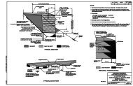
Attachment 1. Preliminary Geologic Map – Point Bonita Lighthouse Area<br />
Arch<br />
Sea<br />
Cave<br />
Arch<br />
29 November 2009
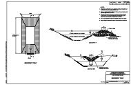
Attachment 2. William Lettis <strong>and</strong> Associates Trail Monitoring Station Map (1 of 2, WLA 1994)<br />
30 November 2009
Attachment 2 William Lettis <strong>and</strong> Associates Trail Monitoring Station Map (2 of 2, WLA 1994)<br />
31 November 2009