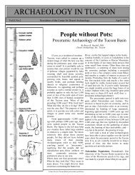
Northern Tucson Basin Archaeological Survey - Archaeology ...
Northern Tucson Basin Archaeological Survey - Archaeology ...
Northern Tucson Basin Archaeological Survey - Archaeology ...

Create successful ePaper yourself
Turn your PDF publications into a flip-book with our unique Google optimized e-Paper software.
Page 4 <strong>Archaeology</strong> in <strong>Tucson</strong> Newsletter Vol. 6, No. 3<br />
permanent occupations that included villages, farmsteads,<br />
agricultural complexes, reservoirs, and numerous small sites<br />
used for a host of other activities. Among the latter were food<br />
collecting and processing sites, and rock quarries for<br />
production of stone tools. By the Classic period many<br />
Hohokam site types, particularly the villages of the preceding<br />
period, continued to be occupied but had become parts of<br />
sprawling platform mound communities.<br />
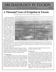
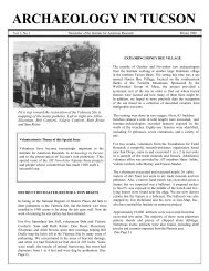
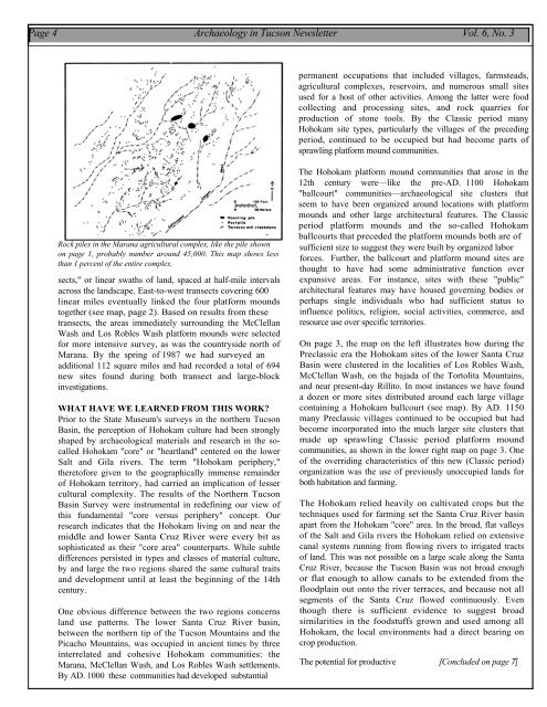
Rock piles in the Marana agricultural complex, like the pile shown<br />
on page 1, probably number around 45,000. This map shows less<br />
than 1 percent of the entire complex.<br />
sects," or linear swaths of land, spaced at half-mile intervals<br />
across the landscape. East-to-west transects covering 600<br />
linear miles eventually linked the four platform mounds<br />
together (see map, page 2). Based on results from these<br />
transects, the areas immediately surrounding the McClellan<br />
Wash and Los Robles Wash platform mounds were selected<br />
for more intensive survey, as was the countryside north of<br />
Marana. By the spring of 1987 we had surveyed an<br />
additional 112 square miles and had recorded a total of 694<br />
new sites found during both transect and large-block<br />
investigations.<br />
WHAT HAVE WE LEARNED FROM THIS WORK<br />
Prior to the State Museum's surveys in the northern <strong>Tucson</strong><br />
<strong>Basin</strong>, the perception of Hohokam culture had been strongly<br />
shaped by archaeological materials and research in the socalled<br />
Hohokam "core" or "heartland" centered on the lower<br />
Salt and Gila rivers. The term "Hohokam periphery,"<br />
theretofore given to the geographically immense remainder<br />
of Hohokam territory, had carried an implication of lesser<br />
cultural complexity. The results of the <strong>Northern</strong> <strong>Tucson</strong><br />
<strong>Basin</strong> <strong>Survey</strong> were instrumental in redefining our view of<br />
this fundamental "core versus periphery" concept. Our<br />
research indicates that the Hohokam living on and near the<br />
middle and lower Santa Cruz River were every bit as<br />
sophisticated as their "core area" counterparts. While subtle<br />
differences persisted in types and classes of material culture,<br />
by and large the two regions shared the same cultural traits<br />
and development until at least the beginning of the 14th<br />
century.<br />
One obvious difference between the two regions concerns<br />
land use patterns. The lower Santa Cruz River basin,<br />
between the northern tip of the <strong>Tucson</strong> Mountains and the<br />
Picacho Mountains, was occupied in ancient times by three<br />
interrelated and cohesive Hohokam communities: the<br />
Marana, McClellan Wash, and Los Robles Wash settlements.<br />
By AD. 1000 these communities had developed substantial<br />
The Hohokam platform mound communities that arose in the<br />
12th century were—like the pre-AD. 1100 Hohokam<br />
"ballcourt" communities—archaeological site clusters that<br />
seem to have been organized around locations with platform<br />
mounds and other large architectural features. The Classic<br />
period platform mounds and the so-called Hohokam<br />
ballcourts that preceded the platform mounds both are of<br />
sufficient size to suggest they were built by organized labor<br />
forces. Further, the ballcourt and platform mound sites are<br />
thought to have had some administrative function over<br />
expansive areas. For instance, sites with these "public"<br />
architectural features may have housed governing bodies or<br />
perhaps single individuals who had sufficient status to<br />
influence politics, religion, social activities, commerce, and<br />
resource use over specific territories.<br />
On page 3, the map on the left illustrates how during the<br />
Preclassic era the Hohokam sites of the lower Santa Cruz<br />
<strong>Basin</strong> were clustered in the localities of Los Robles Wash,<br />
McClellan Wash, on the bajada of the Tortolita Mountains,<br />
and near present-day Rillito. In most instances we have found<br />
a dozen or more sites distributed around each large village<br />
containing a Hohokam ballcourt (see map). By AD. 1150<br />
many Preclassic villages continued to be occupied but had<br />
become incorporated into the much larger site clusters that<br />
made up sprawling Classic period platform mound<br />
communities, as shown in the lower right map on page 3. One<br />
of the overriding characteristics of this new (Classic period)<br />
organization was the use of previously unoccupied lands for<br />
both habitation and farming.<br />
The Hohokam relied heavily on cultivated crops but the<br />
techniques used for farming set the Santa Cruz River basin<br />
apart from the Hohokam "core" area. In the broad, flat valleys<br />
of the Salt and Gila rivers the Hohokam relied on extensive<br />
canal systems running from flowing rivers to irrigated tracts<br />
of land. This was not possible on a large scale along the Santa<br />
Cruz River, because the <strong>Tucson</strong> <strong>Basin</strong> was not broad enough<br />
or flat enough to allow canals to be extended from the<br />
floodplain out onto the river terraces, and because not all<br />
segments of the Santa Cruz flowed continuously. Even<br />
though there is sufficient evidence to suggest broad<br />
similarities in the foodstuffs grown and used among all<br />
Hohokam, the local environments had a direct bearing on<br />
crop production.<br />
The potential for productive [Concluded on page 7]