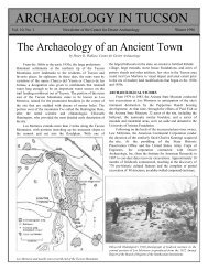
Northern Tucson Basin Archaeological Survey - Archaeology ...
Northern Tucson Basin Archaeological Survey - Archaeology ...
Northern Tucson Basin Archaeological Survey - Archaeology ...

Create successful ePaper yourself
Turn your PDF publications into a flip-book with our unique Google optimized e-Paper software.
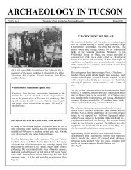
Page 6 <strong>Archaeology</strong> in <strong>Tucson</strong> Newsletter Vol. 6, No. 3<br />
ARCHAEOLOGY PROJECTS FOR VOLUNTEERS<br />
The Lower San Pedro <strong>Archaeological</strong> <strong>Survey</strong>. The<br />
<strong>Archaeology</strong> in <strong>Tucson</strong> program allows its members to<br />
participate in archaeological projects sponsored by the<br />
Center for Desert <strong>Archaeology</strong>. The Center’s current<br />
project is to seek out and document previously<br />
undocumented archaeological sites in the lower San<br />
Pedro Valley east of <strong>Tucson</strong>. In the past 2½ years over<br />
300 prehistoric archaeological sites have been recorded<br />
between Redington and Winkelman by a hundred<br />
volunteers. The fieldwork schedule for the next phase of<br />
this project (which begins in October) will appear in the<br />
next issue of AIT. For more information call (602) 881-<br />
2244.<br />
Excavation Project in Winslow. The Brigham City Fort<br />
was built in what is now Winslow, Arizona, in 1876 by<br />
Mormon settlers colonizing the Little Colorado River<br />
valley. The Fort was a hollow square, 200 feet on a side<br />
with 8-foot-tall stone walls and 10-foot-diameter bastions<br />
at two corners. It also included the pottery kiln of<br />
W.R.O. Behrman—possibly the earliest Anglo-owned<br />
pottery kiln in Arizona. Volunteers may participate in the<br />
Arizona <strong>Archaeological</strong> Society’s excavations at the<br />
Brigham City Fort, September 16-23. For details contact<br />
Alan Ferg at (602) 670-6576.<br />
found there was a prehistoric Hohokam horizon that included a<br />
depression at first thought to be a pithouse but which was<br />
eventually determined to be just a refilled pit. Another test<br />
for the City in June, where a pipeline will be laid near 12th<br />
Avenue and Interstate 19, identified three Rincon phase<br />
Hohokam houses. The City will sponsor excavation of these<br />
features before construction.<br />
Office of Cultural Resource Management, Arizona State<br />
University (Tempe). The third field season of the Roosevelt<br />
Platform Mound Study, sponsored by the Bureau of<br />
Reclamation in conjunction with modifications to Roosevelt<br />
Dam, is winding up. Five Hohokam/Salado platform mounds<br />
were excavated during this project. Three—Pillar Mound,<br />
Pinto Point Mound, and Cline Terrace Mound—are strikingly<br />
similar in their organization of internal space within the<br />
mound's compound. The backs of these mounds had high<br />
sheer walls, but their fronts were characterized by elevated<br />
open areas, and the main entrance in the compound wall was<br />
near the front of the mound. Yet a robust wall connecting the<br />
edge of the mound to the main entrance always prevented<br />
direct access to the front of the mound. To gain access to the<br />
mound's front, a counterclockwise route had to be followed<br />
from the main entrance around the back of the mound. At all<br />
three mounds the counterclockwise route ended in a walled,<br />
ground-level courtyard in front of the open area on the<br />
mound. The pairing of the open area on the mound and the<br />
ground-level courtyard at the end of the counterclockwise<br />
route suggests that these mounds were associated with formal<br />
performance arenas, each with its own stage and audience<br />
area. Interestingly, counterclockwise circuits are depicted in<br />
prehistoric ceramic motifs and are also known from historic<br />
ceremonial contexts and from the oral traditions of Puebloan and<br />
Piman groups.<br />
Pima County Department of Transportation (<strong>Tucson</strong>).<br />
Pima County recently sponsored archaeological sample<br />
surveys that covered 3 square miles to help plan where a new<br />
regional landfill is to be built. Conducted by SWCA, Inc., the<br />
surveys were in three areas south and southeast of <strong>Tucson</strong>.<br />
One archaeological rock cluster, 1 roasting pit, and 1 historic<br />
dump were recorded in the survey area south of <strong>Tucson</strong> near<br />
the ASARCO Mission Mine. Prehistoric sites identified in an<br />
area southeast of <strong>Tucson</strong>'s airport include 2 probable<br />
settlements and 9 agricultural areas characterized by<br />
numerous rock piles and artifact scatters. In the third area<br />
surveyed, near Rita Road west of the County Fairgrounds, 2<br />
isolated rock features and 4 small artifact scatters (some<br />
associated with rock features) were found.<br />
To plan for the widening of Sabino Canyon Road in<br />
northeastern <strong>Tucson</strong>, Pima County contracted Cultural &<br />
Environmental Systems, Inc., to conduct archaeological<br />
testing north of Cloud Road where Sabino Canyon Rd.<br />
crosses or abuts two previously recorded sites. The only<br />
cultural feature identified in test trenches was a large roasting<br />
pit. As this newsletter was going to press the County was<br />
planning to have the roasting pit excavated to recover<br />
archaeological information.<br />
Statistical Research, Inc. (<strong>Tucson</strong>). SRI has been busy on<br />
work for the Pima County Department of Transportation<br />
(PCDOT), Army Corps of Engineers (ACOE), and U.S.<br />
Bureau of Reclamation (USBR). For PCDOT, archaeological<br />
testing was recently completed in a <strong>Tucson</strong> landfill within the<br />
historic San Agustin Mission complex. No significant<br />
archaeological features were found there even though<br />
remnants of several important historic features were<br />
immediately adjacent to the project area.<br />
To help the ACOE plan for bank stabilization projects in<br />
<strong>Tucson</strong>, testing was conducted along the Rillito River at 1<br />
large Hohokam hamlet at the confluence of the Rillito and<br />
Santa Cruz rivers; 2 Hohokam hamlets or farmsteads; 4<br />
Hohokam resource procurement and processing sites; and at 1<br />
historic site near Fort Lowell—the original location of the<br />
Mormon settlement of Binghampton. In another ACOE<br />
project archaeological testing was done at the 49ers site in the<br />
eastern <strong>Tucson</strong> <strong>Basin</strong> along Tanque Verde Creek. Remains of<br />
historic homesteads were found in an area where the ACOE<br />
will build a large earthen dike, and excavations in the core of<br />
the site revealed an early Classic period housing compound.<br />
In Phase 1 of a 4-year excavation project in the lower Verde<br />
River for the USBR, 19 sites near Horseshoe Dam