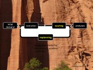
LARGE-SCALE PARALLEL GRAPH-BASED SIMULATIONS - MATSim
LARGE-SCALE PARALLEL GRAPH-BASED SIMULATIONS - MATSim
LARGE-SCALE PARALLEL GRAPH-BASED SIMULATIONS - MATSim

You also want an ePaper? Increase the reach of your titles
YUMPU automatically turns print PDFs into web optimized ePapers that Google loves.
)<br />
¥<br />
£<br />
)<br />
¥<br />
©¡% <br />
Note that this now exactly enforces the storage § <br />
constraint by setting<br />
¢¡¤£<br />
to zero<br />
once ¤#" has reached . In addition, the kinematic jam wave speed is given <br />
explicitly<br />
via . There is some interaction between length of a segment, time step, and that needs to<br />
be considered. The network version of the cell transmission model [16] also specifies how<br />
to implement fair intersections. The cell transmission model is implemented under the name<br />
NETCELL [9].<br />
Other link dynamics are, for example, provided by DynaMIT [19], DYNASMART [20] or<br />
DYNEMO [61]. These are based on the same mass conservation equation as Equation<br />
©¡<br />
(2.1), but<br />
¥<br />
use §<br />
different specifications for . In fact, DynaMIT and DYNASMART calculate vehicle<br />
speeds at the time of entry into the segment depending on the number of vehicles already in<br />
the segment. The number of vehicles that can potentially leave a link in a given time step is, in<br />
consequence, given indirectly via this speed computation. Since this is not enough to enforce<br />
physical queues, physical queuing restrictions are added to this description. DYNEMO varies<br />
a vehicle’s speed continuously along the link based on traffic conditions of the current and the<br />
next segment.<br />
2.4 The Basic Benchmark<br />
A real-world scenario is preferred for the benchmarks throughout this thesis instead of using a<br />
synthetic scenario or using only the theoretical performance predictions.<br />
A theoretical performance prediction gives an idea about what is supposed to be expected.<br />
However, such predictions possibly miss some performance-relevant details that appear only<br />
when the real-world data is used. For example, if an example data set is small enough that it<br />
can fit into a computer’s memory while the real-world data is bigger than the available memory,<br />
the results of theoretical predictions for the small data set will include the cache effects. For<br />
example, if the data set can be kept smaller than the size of the cache, which is a high speed<br />
memory system, there might be a significant speed-up since the data is reached with a higher<br />
speed.<br />
Synthetic scenarios are generated by synthetic data. They are used to make generalizations<br />
about the performance of the real-world scenarios. If a real-world scenario with enough information<br />
to test all the features of a benchmark is not available, a synthetic scenario with full<br />
information is useful. Furthermore, the results are easier to adapt between different scenarios<br />
if it is applicable. On the other hand, if a “possible” real-world data needs to cover a lot of<br />
details, then the generation of a similar synthetic scenario gets harder.<br />
2.5 A Practical Scenario for the Benchmarks<br />
One of the conditions that a traffic flow simulation must fulfill is that the simulation should<br />
be able to run scenarios of a meaningful size within acceptable periods of time. From the<br />
transportation planning point of view, such scenarios are large scale real-world problems, which<br />
include millions of agents and all kinds of traffic.<br />
The street network of Switzerland used in the benchmarks of this thesis was originally<br />
developed for the Federal Office for Spatial Development (ARE) [6]. Then, the network was<br />
extended to include the major European transit corridors for a railway-related study [85]. The<br />
version of the street network used through this thesis is a derivation of the extended network.<br />
It contains 10 564 nodes and 28 622 links.<br />
The nodes of the street network are the intersections of roads and are defined by geographical<br />
coordinates. The links are the roads that connect two nodes. Each link is unidirectional and<br />
15