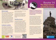
Bayston Hill Walks - Shropshire Walking
Bayston Hill Walks - Shropshire Walking
Bayston Hill Walks - Shropshire Walking

Create successful ePaper yourself
Turn your PDF publications into a flip-book with our unique Google optimized e-Paper software.
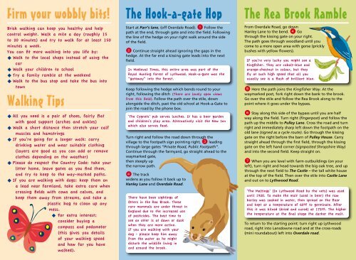
Firm your wobbly bits!<br />
Brisk walking can keep you healthy and help<br />
control weight. Walk a mile a day (roughly 15<br />
to 20 minutes) and try to walk for at least 150<br />
minutes a week.<br />
You can fit more walking into you life by:<br />
u Walk to the local shops instead of using the<br />
car<br />
u Walk your children to school<br />
u Try a family ramble at the weekend<br />
u Walk to the bus stop and take the bus into<br />
town<br />
<strong>Walking</strong> Tips<br />
u All you need is a pair of shoes, fairly flat<br />
with good support (arches and ankles)<br />
u Walk a short distance then stretch your calf<br />
muscles and hamstrings<br />
u If you’re going for a longer walk: carry<br />
drinking water and wear suitable clothing<br />
(layers are good as you can add or remove<br />
clothes depending on the weather)<br />
u Please do respect the Country Code: take your<br />
litter home, leave gates as you find them,<br />
and try to keep to the way-marked paths.<br />
u If you are walking with dogs: keep them on<br />
a lead near farmland, take extra care when<br />
crossing fields with cows and calves, and<br />
keep them away from streams, and take a<br />
plastic bag to clean up any<br />
mess.<br />
u For extra interest;<br />
consider buying a<br />
compass and pedometer<br />
(this gives you details<br />
of your walking speed<br />
and how far you have<br />
walked).<br />
The Hook-a-gate Hop<br />
Start at Parr’s lane, (off Overdale Road). 1 Follow the<br />
path at the end, through gate and into the field. Following<br />
the line of the hedge on your right walk around the side<br />
of the field.<br />
2<br />
Continue straight ahead ignoring the gaps in the<br />
hedge. At the far end a kissing gate leads into the next<br />
field.<br />
In Medieval Times, this entire area was part of the<br />
Royal Hunting Forest of Lythwood. Hook-a-gate was the<br />
“gateway” into the forest.<br />
Keep following the hedge which bends round to your<br />
right, following the ditch (There are lovely open views<br />
from this field). Follow the path over the stile, down<br />
alongside the ditch, past the old school at Hook-a-Gate to<br />
join the road by the phone box.<br />
‘The Cygnets’ pub serves lunches. It has a beer garden<br />
and children’s play area. Alternatively visit the New Inn<br />
which also serves food.<br />
Turn right and follow the road down through the<br />
village to the footpath sign pointing right, 3 leading<br />
through large gates “Private Road, Public Footpath”.<br />
Continue through the farmyard, go straight ahead to the<br />
waymarked gate,<br />
then steeply up<br />
the narrow path.<br />
4<br />
The track<br />
widens as you follow it back up to<br />
Hanley Lane and Overdale Road.<br />
There have been sightings of<br />
Otters in the Rea Brook. These<br />
rare mammals are under threat in<br />
England due to the increased use<br />
of pesticides. The best time to<br />
see an otter is at dawn or dusk<br />
when they are more active.<br />
If you are walking with your<br />
dog - please keep him away<br />
from the water as he might<br />
disturb the wildlife living in<br />
and around the brook.<br />
The Rea Brook Ramble<br />
From Overdale Road, go down<br />
Hanley Lane to the bend. 4 Go<br />
through the kissing gate on your right.<br />
The path goes through woodland until you<br />
come to a more open area with gorse (prickly<br />
bushes with yellow flowers).<br />
If you’re very lucky you might see a<br />
Kingfisher. They are cobalt-blue and<br />
orange-chestnut in colour, but they<br />
fly at such high speed that all you<br />
usually see is a flash of brilliant blue.<br />
5<br />
Here the path joins the Kingfisher Way. At the<br />
waymarked post, fork right down the bank to the brook.<br />
Go over the stile and follow the Rea Brook along to the<br />
point where it goes under the bypass.<br />
6<br />
Stay along this side of the bypass until you are half<br />
way along the field. Turn right (fingerpost) and follow the<br />
path up the middle to Pulley Lane. Cross the road and turn<br />
right and immediately sharp left down the footpath on the<br />
old lane (signed as a cycle route). Go through the kissing<br />
gate on the right before the barn of Pulley House. Carry<br />
straight ahead through the first field, through the kissing<br />
gate on the left hand corner (signposted <strong>Shropshire</strong> Way)<br />
and into the second field. Keep straight on.<br />
7<br />
When you are level with farm outbuildings (on your<br />
left), turn right and head towards the big oak tree, and up<br />
through the next field to The Castle – the tall white house<br />
at the top of the field. Then over the stile into Castle Lane<br />
and out on to Lythwood Road.<br />
‘The Maltings’ (In Lythwood Road by the vets) was used<br />
until 1920. To make the malt (used in beer) the raw<br />
barley was soaked in water, then spread on the floor<br />
and kept at a temperature of 60ºF to germinate. After<br />
this it was kilned (dried and cured) at 172ºF. The higher<br />
the temperature at the final stage the darker the malt.<br />
To return to the starting point: turn right up Lythwood<br />
road, right into Lansdowne road and at the cross-roads<br />
(mini roundabout) left into Overdale road.
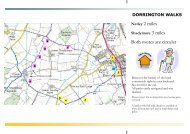
17<br />
19<br />
18<br />
GORSE LANE<br />
Pulley<br />
Hall<br />
& Barns<br />
Cygnets<br />
Upper<br />
Pulley<br />
Church<br />
New Inn<br />
Playground<br />
16<br />
The Three Fishes<br />
SHARPSTONES LANE<br />
Quarry<br />
Plant<br />
Shops & PO<br />
Yards<br />
0 100 200 300 400 500<br />
Community<br />
Woodland<br />
Lythwood<br />
Hall<br />
BMX<br />
Track<br />
Bowling<br />
Green<br />
Games<br />
Courts<br />
Pavilion<br />
The Beeches<br />
Church<br />
Shops &<br />
Parish<br />
Office<br />
The<br />
Compasses<br />
Community<br />
Woodland<br />
& Orchard<br />
<strong>Bayston</strong><br />
Farm<br />
Sharpstones Circular<br />
<strong>Shropshire</strong> Way<br />
Bus Stops<br />
© Crown copyright and database rights<br />
2011 Ordnance Survey 100049049<br />
You are not permitted to copy, sub-licence,<br />
distribute or sell any of this data to third<br />
parties in any form.
More walks<br />
To find out more about walking in<br />
<strong>Shropshire</strong> visit our website at:<br />
www.shropshirewalking.co.uk<br />
or scan with your smartphone<br />
Here you can find hundreds of<br />
walks to download including:<br />
• The <strong>Shropshire</strong> Way<br />
• Circular walks<br />
• Easy Access walks<br />
• Family Friendly walks<br />
• <strong>Walking</strong> for Heath walks<br />
• Podcasts<br />
• Maps and guides<br />
Acknowledgements<br />
With thanks to Pat Moore,<br />
Gerry Lawson and Ted Clarke for<br />
walking and checking the route<br />
information in this leaflet.<br />
Artwork by MA Creative, Shrewsbury<br />
www.macreative.co.uk<br />
www.2shrop.net/baystonhill<br />
The Pulley Stroll<br />
Start at the shops in Lansdowne Road, turn left into Lythwood<br />
Road, then take the first left into Castle Lane, go up the lane,<br />
through the kissing gate to the left of the tall white house.<br />
The big white house is called the Castle. It used to be<br />
a small farm of 9 acres. There was never a castle here<br />
- it’s more likely that the farmer who lived here chose<br />
the name to impress his neighbours!<br />
Head straight down the field to the big oak tree and into the<br />
next field. Carry on to point 7 then turn right, follow the<br />
path, over the footbridge over Bran brook, on to the substation<br />
in Lower Pulley Lane. Turn right and walk up towards the A49.<br />
At the junction turn left down the A49 to The Three Fishes pub<br />
and the start of the Sharpstone Quarry Circular Walk ) . OR:<br />
Cross the A49 into Cross Lane. where two tracks cross. Turn<br />
right up the narrow track to The Common. 8<br />
You can see Sharpstones Quarry which is owned by<br />
Tarmac. It’s a mile long and covers 133 acres. They<br />
extract one million tonnes of stone every year - that’s<br />
4,000 tonnes every day.<br />
Turn right and walk down the road (past the old church) to<br />
the A49. Carefully cross main road via refuge and go left<br />
up the A49. Carry on over cross roads junction opposite The<br />
Compasses pub to end of the built-up area.<br />
‘The Compasses Inn’ has a beer garden backing on to<br />
The Common.<br />
9<br />
At the first field on the right, go through the kissing<br />
gate in the near corner. Head straight up the field,<br />
follow the path round the top of the field and through a<br />
waymarked wooden gate in to the alleyway which bends<br />
back into Betley Lane.<br />
Go up the lane. Take the first turn on the right onto Lyth<br />
<strong>Hill</strong> Road. Cross over. Turn right down the road. Next<br />
to house number 72, take the narrow drive on the left<br />
leading to the Glebelands playing fields. At the fence turn<br />
left and follow the footpath on to the playing field. Follow<br />
the old school boundary to the gate in the right hand<br />
corner of the playing field.<br />
Follow the footpath out on to Glebe Road. Turn right, back<br />
to Lythwood Road by the Library, then turn left and follow<br />
the road downhill to the start point. !<br />
The Peacock Panorama<br />
From the Library in Lythwood Road, go along Glebe Road.<br />
Take the path on the left between the old school<br />
and the church to the Glebelands playing fields. !<br />
Cut diagonally across to the gate by the Scout<br />
and Guide hut, turn right on the road and<br />
immediately left into Yew Tree Drive.<br />
Go left up the alley between no.s 66<br />
and 68. Keep right at the metal barrier then go the kissing<br />
gate into the field, # follow the hedge up to the top left<br />
hand corner of the field and go over the next stile.<br />
This walk has panoramic views: in the first field look<br />
back for a view over Shrewsbury and North <strong>Shropshire</strong>;<br />
in the second field look right for westward views of<br />
Pontesford and the Stiperstones; in the third field, look<br />
left for views East to the Wrekin.<br />
Skirt round the left hand edge of this second field. Take<br />
the next stile on your left into the third field. Turn right<br />
and go along the right-hand field edge (follow overhead<br />
lines). At the second electricity pole, turn left across the<br />
field, in-line with three oak trees.<br />
Go over the stile to the left of the final oak tree, along the<br />
path between the gardens and out onto Lyth <strong>Hill</strong> Road.<br />
Cross the road to the gate $ to enjoy the view eastwards.<br />
FOR AN ALTERNATIVE WALK: turn right up the road to<br />
Lyth <strong>Hill</strong> and Spring Coppice. Further details of walks on<br />
Lyth <strong>Hill</strong> are available at <strong>Bayston</strong> <strong>Hill</strong> Library or on the<br />
web www.shropshirewalking.co.uk<br />
See the Wrekin, Ironbridge Power Station and Condover.<br />
Turn left down the road (face oncoming traffic for safety).<br />
A wide variety of plants grow in the high-banked hedge<br />
on your right. To work out how old a section of hedge<br />
is - count the number of different species of trees you<br />
can see growing in it – It’s roughly 100 years old for<br />
every species you can find!<br />
You may hear and see the peacocks at The White House on<br />
your right. They can often be seen strutting in the road.<br />
For a short detour with views over Condover and the<br />
Wrekin, go through the kissing gate on the right into<br />
the Horse Fields just before you re-enter <strong>Bayston</strong> <strong>Hill</strong>.
Continue down Lyth <strong>Hill</strong> Road, just past Eric Lock Road and<br />
immediately before no. 103 turn right into Betley Lane.<br />
Follow the lane around and at ‘Bolventur’ turn left and<br />
out on to Lyth <strong>Hill</strong> Road. See the Pulley Stroll directions for<br />
returning across the Glebelands to the library.<br />
The Lythwood Wander<br />
By kind permission of <strong>Shropshire</strong> Council and <strong>Bayston</strong> <strong>Hill</strong> Parish Council.<br />
From Overdale Road go down Parr’s Lane to the end. Turn<br />
left along the alleyway and into Mayfield Grove and carry<br />
on along the cul-de-sac. At the cross-roads go straight across<br />
up Mayfield Grove to the ‘T’ junction at the top (Brookfield).<br />
Turn right along Brookfield and turn right after house no.<br />
34. Go through the gateway at the end of the road, and<br />
follow the easy access path down to Parrs Pool. Take the<br />
circular route around the pool and over the boardwalk (see<br />
ducks and moorhens)<br />
The Community Woodland is planted to recreate a Medieval<br />
coppice wood. The woodland contains oak, ash and alder<br />
which will be left to grow into full trees. There are also<br />
hazel, field maple and hawthorn which will be coppiced<br />
(cut back every few years and allowed to regrow).<br />
%<br />
Keep on to the end of the stone path then walk<br />
through the new plantation to the end and then turn left<br />
on to the playing field. Keeping the wood on your right,<br />
walk up the field past the BMX track on to Lythwood Hall<br />
Lane. Turn right along the lane to gated access to the new<br />
woodland on the left.<br />
& Walk up the easy access path through the new planting<br />
passed orchard and sensory garden to gap in the top left<br />
corner. Just through the gap you can cross over the ditch<br />
on right in hedge and turn right up the track to Lythwood<br />
Farm ( and continue to Lyth <strong>Hill</strong> for a long walk. OR walk<br />
on down the path, along side the allotments on the left in<br />
to Y&CB car park in Lythwood Hall Lane.<br />
Lythwood Farm. In 1590 this area used to be a woodland<br />
called ‘Higgons Hay’. The farmhouse was built around<br />
this time.<br />
b) Follow the lane on to Lythwood Road and carry on to<br />
the junction with Overdale Road and Glebe Road. Turn left<br />
along Overdale Road to your starting point.<br />
OR c) turn right in to Glebe Road then first right into<br />
Yew Tree Drive, then right at the public footpath sign<br />
alongside house no. 40, through the kissing gate and<br />
straight on across the field to join the “Peacock Panorama”<br />
beyond Point # .<br />
Sharpstones Circular<br />
Start at the ‘Three Fishes’ pub ) and cross the A49, with<br />
care, onto old Sharpstones Lane opposite. Passing behind<br />
the bus stop, between the cottages and the hedged utility<br />
cabin, follow the lane down past the bungalows to the<br />
bottom and turn right over the railway bridge into the<br />
quarry processing area.<br />
Be very wary of busy lorry traffic in this area and carefully<br />
follow the direction notices on the buildings up through<br />
the yellow gateway, along the lane and round the bend<br />
towards Bomere Farm. About 500m downhill where the<br />
lane branches left you will see a kissing gate which takes<br />
you up the new path around the top edge of the quarry<br />
workings. As you climb to the highest point look out on<br />
your left for a pile of fossilised tree trunks, excavated<br />
during the quarry extension. On your right notice the<br />
extensive meadow planting right across the slope.<br />
Walk right along the ridge to a wooden kissing gate and<br />
turn left back onto the farm lane. Continue up the lane<br />
and round the sweeping bend until you notice a Quarry<br />
Blasting Time Board on the left, next to a kissing gate. Pass<br />
through this gate on to a new Permissive Path around the<br />
left edge of the field, and enjoy the view of Shrewsbury<br />
and the football ground on your right. Keep following the<br />
field edge through a stock gate and kissing gate until you<br />
see a stile. Ignore the stile and instead turn right through<br />
another kissing gate and walk down across this sloping<br />
field to the hedge line alongside the elevated A5 bypass.<br />
Follow this hedge line left, ignoring the A5 underpass on<br />
your right, alongside the small stream until you reach the<br />
old railway bridge. *<br />
Cross over the line and follow the<br />
track to a gate onto the A49, opposite the Garden Centre.<br />
Very carefully cross the road and turning left follow the<br />
pavement back up into <strong>Bayston</strong> <strong>Hill</strong>. OR over the stile +<br />
behind the garden centre and down the track to stile on<br />
the right. Go over this and keep left on to the lane at<br />
Pulley Hall Barns ,<br />
and left, back up lane to <strong>Bayston</strong> <strong>Hill</strong>.<br />
Stretch your legs and explore the countryside<br />
right on the doorstep!<br />
Discover the fields and farmland, the pools and<br />
streams, and the woodland dells within a 10 minute<br />
walk from your home.<br />
These walks are moderate (with a few stiles).<br />
On average they take around 40 – 60 minutes, or you<br />
can join them up for a mini expedition!