Guide Book PDF - Shropshire Walking
Guide Book PDF - Shropshire Walking
Guide Book PDF - Shropshire Walking

You also want an ePaper? Increase the reach of your titles
YUMPU automatically turns print PDFs into web optimized ePapers that Google loves.
RIVER TEME<br />
Weir<br />
RIVER CORVE<br />
Dinham<br />
Bridge<br />
Whitcliffe<br />
Common<br />
L I N N E Y<br />
DINHAM<br />
Ludlow<br />
Castle<br />
W H I T C L I F F E<br />
CAMP LANE<br />
LINNEY<br />
LINNEY<br />
R O A D<br />
MILL STREET<br />
Weir<br />
RAVEN<br />
B4361<br />
COLLEGE ST<br />
BROAD STREET<br />
BELL LANE<br />
LANE<br />
CORVE STREET<br />
KING ST<br />
LANE<br />
SILK MILL<br />
STATION DRIVE<br />
BRAND LANE<br />
HILLSIDE<br />
HENLEY ROAD<br />
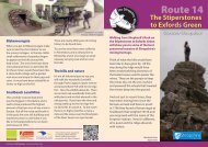
Ludlow<br />
Ludlow – As Betjeman said – “The most<br />
perfect town in England” built 900 years<br />
ago by the Normans and steeped in<br />
history at every turn. A true market town<br />
with so many delights to tempt the tired<br />
walker to linger and stay a while.<br />
LOWER BROAD<br />
B4361<br />
ST JOHN’S ROAD<br />
Caynham Camp<br />
Take some time to explore this ancient hill<br />
fort with its well preserved ramparts and<br />
terraces; it was occupied 3000 years ago.<br />
Once it would have been so busy, full of<br />
noise, people, animals and smoky round<br />
houses; now it stands quiet. In those days<br />
the view would have been woodland,<br />
now it a quilt of farmland in which Ludlow<br />
stands proud.<br />
STREET<br />
NEW ROAD<br />
ST JOHNS LANE<br />
PARK ROAD<br />
UPPER GALDEFORD<br />
OLD STREET<br />
AVENUE<br />
GRAVEL HILL<br />
TEME<br />
POYNER ROAD<br />
LOWER GALDEFORD<br />
Weir<br />
T E M E S I D E<br />
ST JULIAN’S AVENUE<br />
WEEPING CROSS LANE<br />
ROCK L A N E<br />
SHEE T ROA D<br />
Weir<br />
RIVER TEME<br />
LUDLOW<br />
S T E V ENTON N E W ROAD<br />
T E M E S I DE<br />
STEVENTON ROA D<br />
Ludlow from the keep to the Clee Hills<br />
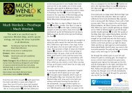
Titterstone<br />
Clee<br />
The third highest hill<br />
in <strong>Shropshire</strong> has<br />
been worked since<br />
the Iron Age. Once<br />
a huge stone-walled<br />
hill fort covered the<br />
top but little can now<br />
be seen. The hill has<br />
been carved away<br />
and reshaped in the<br />
search for coal, limestone and dhustone.<br />
Dhustone, the hard dark rock that is<br />
crushed to carpet our roads: Little pieces<br />
of <strong>Shropshire</strong> found all over the Country.<br />
Sheet<br />
BEWARE – the route from the village of<br />
Sheet is along a narrow road with no<br />
footpath and a blind bend. If you are in<br />
a large group or worried about the traffic<br />
then take the detour through Lower<br />
Ledwyche and backtrack to Caynham<br />
Camp.<br />
A49<br />
SHEE T ROAD<br />
Electricity<br />
Sub Station<br />
SW Diversion<br />
to Ludlow<br />
PARYS ROAD<br />
Lower<br />
Ledwyche<br />
Little Ledwyche<br />
Farm<br />
Sheet<br />
SHROPSHIRE WAY<br />
A49<br />
Caynham<br />
Cottage<br />
Poughnhill<br />
Caynham<br />
Camp<br />
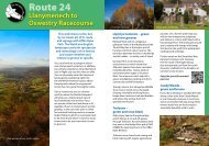
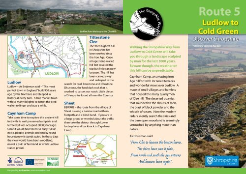
<strong>Walking</strong> the <strong>Shropshire</strong> Way from<br />
Ludlow to Cold Green will take<br />
you through a landscape sculpted<br />
by man for the last 3000 years.<br />
Beware though, the weather on<br />
this hill can be unpredictable.<br />
Caynham Camp, an amazing Iron<br />
Age hillfort with its tiered terraces<br />
and wonderful views over Ludlow. A<br />
maze of small villages and hamlets<br />
that housed the many quarrymen<br />
of Clee hill. The deserted quarries<br />
that sounded to the shouts of men,<br />
the blast of black powder and the<br />
whistle of steam. Now the modern<br />
radars silently search the skies and<br />
the bare open moorland is seemingly<br />
untouched by anything more than<br />
nature.<br />
As Housman said:<br />
“From Clee to heaven the beacon burns,<br />
The shires have seen it plain,<br />
From north and south the sign returns<br />
And beacons burn again”.<br />
Route 5<br />
Ludlow to<br />
Cold Green<br />
Discover <strong>Shropshire</strong><br />
Titterstone Clee Iron Age fort<br />
Designed by MA Creative • www.macreative.co.uk
View from Titterstone Clee Hill<br />
Clee St Margaret<br />
Discover <strong>Shropshire</strong><br />
Cold Weston<br />
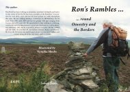
Route 5<br />
<strong>Shropshire</strong> Way Footpaths Bridleways<br />
Circular walk<br />
Open Access land<br />
DIFFICULTY: Some steep sections and<br />
high moorland<br />
Stoke<br />
St Milborough<br />
Coldgreen<br />
Wheathill<br />
Visitor Information Centre<br />
Café<br />
Public House<br />
Toilets<br />
Building of Historical Interest<br />
Place of Worship<br />
Caravan/Camping Site<br />
Museum<br />
Car Parking<br />
Railway Station<br />
10 mile section<br />
Hopton<br />
Changeford<br />
B4364<br />
Cleedownton<br />
Bromdon<br />
Castle<br />
Gardens<br />
Visitor Attractions<br />
English Heritage<br />
National Trust<br />
Forestry Commission<br />
Stanton<br />
Lacy<br />
Hill summit<br />
Youth Hostel<br />
TITTERSTONE<br />
CLEE HILL<br />
Clee St Mary<br />
B4361<br />
B4364<br />
Bitterley<br />
Hoptonbank<br />
A49<br />
Bromfield<br />
Middleton<br />
B4361<br />
A4117<br />
Henley<br />
Dhustone<br />
A4117<br />
Doddington<br />
Priors Halton<br />
LUDLOW<br />
Snitton<br />
Cleehill<br />
Ludford<br />
Sheet<br />
Knowbury<br />
B4214<br />
Hope<br />
Bagot<br />
0 KILOMETRES 2 3 4<br />
0 MILES 1 2<br />
For a more detailed map directions and information visit:<br />
www.shropshirewalking.co.uk<br />
Caynham Camp<br />
Caynham<br />
Whitton<br />
Wooton<br />
500m<br />
400m<br />
300m<br />
200m<br />
100m<br />
Ludlow<br />
Bypass<br />
Kilometres<br />
Knowlegate<br />
A4417<br />
Caynham<br />
Camp<br />
Titterstone Clee<br />
2 4 6 8 10<br />
0 Miles 2<br />
4 6 8<br />
Cold<br />
Green<br />
12 14<br />
Crown Copyright. All rights reserved. <strong>Shropshire</strong> Council 100019801. 2009