Route 24 - Shropshire Walking
Route 24 - Shropshire Walking
Route 24 - Shropshire Walking

You also want an ePaper? Increase the reach of your titles
YUMPU automatically turns print PDFs into web optimized ePapers that Google loves.
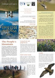
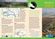
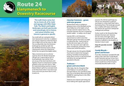
<strong>Route</strong> <strong>24</strong>Llanymenech toOswestry RacecourseThis walk shares some, butby no means all, of its routeand signage with Offa’s DykePath. The Welsh and Englishlandscapes are both spectacularand rewardingly rich in historyand nature whether yourinterest is general or specific.You could well see a peregrine falconnear Llanymynech rocks but, in addition,you will also experience what that falconsees in flight such are the views on offer.You can physically enter the limestonelandscape by wandering right intothe old Welsh limestone quarry aboveLlanymynech where the engineeredterrain has now gone thoroughly native.Take a moment to rest on a formerspoil tip where the ‘Border Viewpoint’will give you a toposcopical view oflocal landmarks near and far. If youare unsure of the time look down at StAgatha’s Church in Llanymynech and begrateful, as the rock men were in 1844,for industrial knitting machine inventorRobert Robert’s gift of an oversized clockto let them know when it was time to gohome and to let you know that it’s timeto press on.Llynclys CommonLlynclys Common – greenand now greenerBlodwel Rock with its vertiginousglimpsed views of the Moelydd and theTanat Valley lies at the higher end ofLlynclys Common nature reserve. Thetransition between the two is marked byJacob’s Ladder – in reality a set of steps!Llynclys Hill is a rich limestoneenvironment on which more than300 plant species have been recordedincluding fairy flax, twelve kinds oforchid and seven types of St John’sWort. You may even catch sight of agreen woodpecker pecking ants fromcarbuncular anthill formations.Though natural, this <strong>Shropshire</strong> WildlifeTrust reserve needs to be managed.Grazing, inevitably involving fences,keeps down invasive scrub and brackenand allows the springy herb richgrassland to flourish.Trefonen –green and once blackOffa’s Dyke, like the <strong>Shropshire</strong> Waywhich follows it on and off, passesthrough Trefonen. No coincidence thenthat next to the Barley Mow pub (01691656889 for opening hours) is the Offa’sDyke Brewery.Barley Mow and Brewery, Trefonenpursuits. On a former spoil heap youwill see two interpretive sculpturesand, below it, a mine shaft ‘head’ with afascinating ‘fence’. The landscape aroundyou is replete with lumps and bumpsthat denote the spoil from widespreadunderground workings.Further south on the <strong>Shropshire</strong> Waybetween Gronwen and SweeneyFen the route of the light railwaythat transported coal from the southOswestry coalfields to the limekilns atLlynclys is easy to spot.Enjoy the specially recordedpod cast.Candy Woods –green and brownIf you like a deciduous wooded hill walkalong a clear trails then Candy Woodsis your heavenly stairway. It even has astone carved seat half way along whereminers would rest on their long butseasonally beautiful walk to work.Miner’s seat in Candy WoodsView westward from Jacob’s LadderTrefonen once shared coal mining andbrick making with regular agricultural
R iv e rM or daLlawntBaker’s HillRhydycroesauOld OswestryRacecourseOffa’s DykeDiscover <strong>Shropshire</strong>RacecourseWoodB4580Castell BrogyntynBrogyntyn ParkB4579Wat’s D<strong>Route</strong> <strong>24</strong>WhittingOldOswestryFortB5069Park HallFarmPark HallB50090 1 2KILOMETRESCandyWoodB&BSheepWalkBwlchLlanfordaWoodLlanfordaCircularOSWESTRY0 MILES½1B4579ServicesA5MiddletonTyn-y-CoedRiver MordaA483SummerHillOffa’s DykeCollierySculpturesMordaB5069WestonTrefonenGronwenSweeneyHall HotelCrumpwellSweeneyMountainNantmawrNantmawrQuarryPorth-y-WaenTreflachOffa’s DykeAsterleyRocksWhitehavenLlynclysQuarryA495Jacob’s LadderBlodwelRockLlanymynechHillDolgoch QuarryNature ReserveLlynclysHillCrickheathHillPantLimeKilnsSweeney FenNature ReserveA483LynclysPoolLlynclysCambrianHeritageRailwayMortonCrickheath<strong>Route</strong> Profile300m250m200m150m100mKilometresMiles2MaesburyB4396Rivear M ord4 68MaesburyMarshSt Winifred’s WellWoolstonDIFFICULTY: some steep uphill sections.8.5 miles / 13.6 kilomertres10 12 141 2 3 4 5 6 7 8Montgomery CLlanymynechSt Benion’sWellLlanymynechHeritage SiteB4398MaesbrookFor a more detailed map directions and information visit:www.shropshirewalking.co.ukYou are not permitted to copy, sub-licence, distribute or sell any of this data to third parties in any form. ©Crown copyright and database rights 2012 Ordnance Survey 100049049