Rp of Chalk Gobindapur - LGED
Rp of Chalk Gobindapur - LGED
Rp of Chalk Gobindapur - LGED

You also want an ePaper? Increase the reach of your titles
YUMPU automatically turns print PDFs into web optimized ePapers that Google loves.
3. Area and Location<br />
5. The subproject as proposed has a gross area <strong>of</strong> 870 ha with a net benefited area <strong>of</strong><br />
470 ha. The subproject is bounded by a kacha road to the North, a village road to the South<br />
and East and Nayela River to the West. The <strong>Chalk</strong> <strong>Gobindapur</strong> – Aldadpur khal , the principal<br />
drainage channel , originates from local depression within the subproject area and<br />
passes through the subproject area and falls in Nayela River. The only drainage Khal has<br />
been silted up.<br />
6. Some 7705 people live in1325 households (HHs) in the subproject area. The average<br />
number <strong>of</strong> people per household in the subproject area is 5.8. Of these a total <strong>of</strong> 3,154<br />
people in 618 HHs are considered to be subproject beneficiaries.<br />
7. The main problem is the shortage <strong>of</strong> irrigation water in Dry Seasons, and late drainage<br />
at the end <strong>of</strong> Monsoon. The farmer cannot cultivate HYV Boro crops in time due to<br />
shortage <strong>of</strong> water. Late drainage at the end <strong>of</strong> Monsoon causes late plantation <strong>of</strong> Boro and<br />
Rabi crops .<br />
8. The situation may improve by re- excavating <strong>Chalk</strong> <strong>Gobindapur</strong> –Aldadpur Khal from<br />
its <strong>of</strong>f take to the outfall and constructing one water retention structure, at the out fall <strong>of</strong> the<br />
<strong>Chalk</strong> <strong>Gobindapur</strong> –Aldadpur khal . The re -excavation <strong>of</strong> khal will remove the drainage congestion.<br />
Drainage improvement will also increase in some areas for Rabi crops and facilitate<br />
plantation <strong>of</strong> HYV Boro in time.<br />
9.. There are two existing culverts within the alignment <strong>of</strong> the <strong>Chalk</strong> <strong>Gobindapur</strong> –<br />
Aldadpur Khal. As their floors are too high to be viable, one box culvert will be lowered for<br />
proper drainage <strong>of</strong> the subproject area and the other one will be rehabilitated with a new<br />
gate structure for the drainage and storage <strong>of</strong> water in the khal. The rehabilitated gated<br />
structure will facilitate storage <strong>of</strong> water in the <strong>Chalk</strong> <strong>Gobindapur</strong>–Aldadpur Khal and in the<br />
beel (natural depression that may or may not retain water throughout the year) for irrigation<br />
in the Dry Season. The Characteristics <strong>of</strong> wet land within the subproject area will be enhanced<br />
due to the enhanced storage <strong>of</strong> water in the khal; and more tree plantation along<br />
both banks <strong>of</strong> the khal will be possible.<br />
10. Proposed interventions in this subproject will not directly cause any adverse impact,<br />
neither on the fisheries resource base or production, but they will create added fisheries habitat<br />
in the re-excavated canal, supported by the water retaining structures. Added fisheries<br />
development measures proposed for the subproject will significantly increase the fisheries<br />
production potential. Increased fish production and increased access <strong>of</strong> poor to the fisheries<br />
income will contribute to poverty alleviation.<br />
11. There are six villages namely: (i) <strong>Chalk</strong>gobindapur; (ii) Aldadpur (iii) Badal Khal; (iv)<br />
Noyanpur (v) Moheshpuri and Sherpur, covering a gross cultivable land <strong>of</strong> 870 hectares.<br />
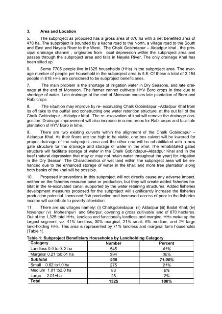
Out <strong>of</strong> the 1,325 total HHs, landless and functionally landless and marginal HHs make up the<br />
largest segment, viz: 41% landless, 30% marginal, 21% small, 6% medium, and 2% large<br />
land-holding HHs. This area is represented by 71% landless and marginal farm households<br />
(Table 1).<br />
Table 1: Subproject Beneficiary Households by Landholding Category<br />
Category Number Percent<br />
Landless 0.0 to 0. 2 ha 545 41%<br />
Marginal 0.21 to0.61 ha 394 30%<br />
Subtotal 939 71.00%<br />
Small 0.62 to1.0 ha 275 21%<br />
Medium 1.01 to2.0 ha 83 6%<br />
Large 2.01+ha 28 2%<br />
Total 1325 100%