The Comprehensive Plan - City of Champaign
The Comprehensive Plan - City of Champaign
The Comprehensive Plan - City of Champaign

Create successful ePaper yourself
Turn your PDF publications into a flip-book with our unique Google optimized e-Paper software.
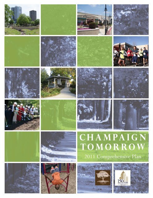
<strong>Champaign</strong><br />
Tomorrow<br />
2011 <strong>Comprehensive</strong> <strong>Plan</strong>
INTRODUCTION 1<br />
Table <strong>of</strong> Contents<br />
i. Introduction 3<br />
Letter from Mayor Schweighart......................................3<br />
Purpose <strong>of</strong> the <strong>Comprehensive</strong> <strong>Plan</strong>................................4<br />
History <strong>of</strong> <strong>Comprehensive</strong> <strong>Plan</strong>ning.................................5<br />
<strong>Comprehensive</strong> <strong>Plan</strong> Elements......................................8<br />
Update Process........................................................10<br />
<strong>Plan</strong>ning Framework.................................................12<br />
Building a Complete Community..................................14<br />
<strong>Champaign</strong> <strong>City</strong> Council<br />
Jerry Schweighart, Mayor<br />
Michael La Due, Deputy Mayor<br />
Thomas Bruno<br />
Linda Cross<br />
Marci Dodds<br />
Deborah Frank Feinen<br />
Karen Foster<br />
Kyle Harrison<br />
Will Kyles<br />
Steven C. Carter, <strong>City</strong> Manager<br />
Dorothy A. David, Asst. <strong>City</strong> Manager<br />
<strong>Champaign</strong> <strong>Plan</strong> Commission<br />
Terry Dudley, Chairperson<br />
Jon Bryan<br />
Paul Cole<br />
Mark Darling<br />
Brian DeMuynck<br />
John Dodson<br />
Leonard Heumann<br />
Robert Miller<br />
Laurie Reynolds<br />
<strong>Champaign</strong> Tomorrow Team<br />
Bruce A. Knight, FAICP, Director<br />
Rob Kowalski, AICP, Asst. Director<br />
Zeba Aziz, <strong>City</strong> <strong>Plan</strong>ner<br />
Lacey Rains, <strong>City</strong> <strong>Plan</strong>ner<br />
Mishauno Woggon, <strong>City</strong> <strong>Plan</strong>ner<br />
Vinod Kadu, Graduate Intern<br />
Robby Boyer, Graduate Intern<br />
II. Vision & Guiding Principles 17<br />
Assembling <strong>of</strong> the Vision & Guiding Principles..................18<br />
Vision & Guiding Principles Summary............................18<br />
Growing <strong>City</strong>..........................................................20<br />
Sustainable <strong>City</strong>.......................................................26<br />
Complete Neighborhoods..........................................30<br />
Community Identity.................................................34<br />
Healthy Community.................................................40<br />
Complete Public Facilities..........................................44<br />
III. Future Land Use 51<br />
Future Land Use Categories........................................52<br />
Neighborhoods.......................................................54<br />
Centers................................................................58<br />
Community Destinations...........................................62<br />
Growth Area Criteria................................................64<br />
Street Classification Descriptions and Maps.......................66<br />
Future Land Use Maps..............................................69<br />
Growth Area A - L..............................................71<br />
<strong>City</strong> Map..........................................................95<br />
DRAFT 2-10-11
2<br />
CHAMPAIGN TOMORROW - COMPREHENSIVE PLAN<br />
DRAFT 2-10-11
INTRODUCTION 3<br />
In our next 20 years...<br />
<strong>Champaign</strong> yesterday, today and tomorrow<br />
As we celebrate the 150th anniversary <strong>of</strong> the founding <strong>of</strong> the <strong>City</strong> <strong>of</strong><br />
<strong>Champaign</strong> today, it is an excellent time to prepare a plan for tomorrow.<br />
<strong>Champaign</strong> Tomorrow builds on our history to guide us to a bright<br />
future. <strong>The</strong> <strong>Plan</strong> outlines a vision for <strong>Champaign</strong> with a bustling center<br />
city, desirable neighborhoods connected to attractive commercial areas<br />
and a world class university.<br />
<strong>Champaign</strong> has a strong history <strong>of</strong> city planning, going back to 1926. In<br />
recent years, sound planning has resulted in the rebirth <strong>of</strong> Downtown<br />
and Campustown that continues today. <strong>Plan</strong>ning has also been key<br />
to neighborhood revitalization as witnessed in the Douglass Square<br />
neighborhood. Now there are exciting new opportunities throughout<br />
the <strong>City</strong> guided by planning, including the Curtis Road interchange<br />
area.<br />
A community that is proactive and prepared for change is a community<br />
prepared for success. In light <strong>of</strong> recent changes to our economy, our<br />
world and our community, implementing this vision for a fiscally,<br />
environmentally and socially sustainable future is paramount. <strong>The</strong><br />
recommendations <strong>of</strong> this plan will be implemented over many years<br />
with cooperation, patience and diligence. I look forward to working<br />
together to bring this vision to life.<br />
Mayor Gerald Schweighart<br />
DRAFT 2-10-11
4<br />
CHAMPAIGN TOMORROW - COMPREHENSIVE PLAN<br />
<strong>The</strong> Purpose <strong>of</strong> the <strong>Comprehensive</strong> <strong>Plan</strong><br />
<strong>The</strong> purpose <strong>of</strong> a <strong>Comprehensive</strong> <strong>Plan</strong> is to establish<br />
a vision for how the community wants to grow<br />
and develop over a twenty-year horizon. <strong>The</strong><br />
<strong>Comprehensive</strong> <strong>Plan</strong> uses knowledge from the past<br />
and today to plan ahead and ensure that growth is<br />
fostered in a way that maintains the quality <strong>of</strong> life<br />
<strong>Champaign</strong> residents currently enjoy.<br />
<strong>The</strong> <strong>City</strong> <strong>of</strong> <strong>Champaign</strong> has engaged in<br />
comprehensive planning since 1926 and most<br />
recently adopted a plan in 2002. However, significant<br />
development activity in the community over the<br />
past ten years along with the recent unprecedented<br />
change in the local and national economy make it an<br />
appropriate time to revisit the current plan.<br />
<strong>The</strong> Functions <strong>of</strong> a<br />
<strong>Comprehensive</strong> <strong>Plan</strong>:<br />
ESTABLISHES A COMMUNITY VISION:<br />
Each community has their own set <strong>of</strong> values<br />
that contributes towards their quality <strong>of</strong> life.<br />
Crafting a vision that captures these values is<br />
one <strong>of</strong> the most important components <strong>of</strong> the<br />
comprehensive plan. <strong>The</strong> vision is used to draft<br />
the guiding principles, actions and future land use<br />
maps in the comprehensive plan.<br />
ANTICIPATES THE FUTURE NEEDS<br />
OF THE COMMUNITY:<br />
<strong>The</strong> exercise <strong>of</strong> preparing a comprehensive plan<br />
includes studying recent growth trends and other<br />
aspects <strong>of</strong> the community to help understand<br />
what the future needs may be. For example, is<br />
the existing infrastructure adequate to serve a<br />
growing population or will additional capacity to<br />
existing infrastructure systems need to be added<br />
Following WWII, a dramatic increase in enrollment at the University<br />
<strong>of</strong> Illinois resulted in a severe housing shortage. A neighborhood <strong>of</strong><br />
manufactured homes was erected adjacent to Memorial Stadium, seen<br />
here in 1946, to house students and their families.<br />
<strong>The</strong> <strong>Comprehensive</strong> <strong>Plan</strong> establishes a guide for all<br />
residents in the <strong>City</strong> as to the growth and anticipated<br />
use <strong>of</strong> property in the future. <strong>The</strong> <strong>Comprehensive</strong><br />
<strong>Plan</strong> is a policy document that is a precursor to the<br />
Zoning Ordinance and Map. <strong>The</strong> Zoning Ordinance<br />
and Map are the regulations that legally enact and<br />
enforce the vision <strong>of</strong> the <strong>Comprehensive</strong> <strong>Plan</strong>.<br />
PRESENTS THE STRATEGY FOR<br />
GROWING IN A RESPONSIBLE AND<br />
SUSTAINABLE MANNER:<br />
It is important for communities to be able to<br />
grow but it needs to be done responsibly and not<br />
diminish the quality <strong>of</strong> life. <strong>The</strong> comprehensive<br />
plan is an opportunity to describe how growth<br />
can be accommodated in the most efficient and<br />
sustainable way. For example, establishing policies<br />
that promote the redevelopment <strong>of</strong> the core <strong>of</strong><br />
the community before further development on<br />
the fringe would help achieve this goal.<br />
DRAFT 2-10-11
INTRODUCTION 5<br />
Where we’ve been...<br />
A history <strong>of</strong> planning in <strong>Champaign</strong><br />
Explain the history <strong>of</strong> comprehensive planning in <strong>Champaign</strong> and the accomplishments<br />
along the way<br />
Quote from the 1926<br />
<strong>Comprehensive</strong> <strong>Plan</strong><br />
Text<br />
Text<br />
Text<br />
DRAFT 2-10-11
6<br />
CHAMPAIGN TOMORROW - COMPREHENSIVE PLAN<br />
• Hold for Bruce<br />
Looking southeast at the Prospect Avenue and I-74 interchange.<br />
DRAFT 2-10-11
INTRODUCTION 7<br />
• Hold for Bruce<br />
Looking southwest at the newly constructed Marketplace Mall..<br />
DRAFT 2-10-11
8<br />
CHAMPAIGN TOMORROW - COMPREHENSIVE PLAN<br />
<strong>The</strong> <strong>Comprehensive</strong> <strong>Plan</strong> ‘Elements’<br />
<strong>The</strong> <strong>Comprehensive</strong> <strong>Plan</strong> is not a stand-alone document. Rather, it serves as an “umbrella” for<br />
several other planning studies more focused on a specific area or subject. <strong>The</strong> <strong>Comprehensive</strong> <strong>Plan</strong><br />
establishes the overall vision for the future <strong>of</strong> the community but it cannot get into the detail that<br />
some areas <strong>of</strong> the city require. For example, the <strong>Comprehensive</strong> <strong>Plan</strong> recognizes the importance<br />
<strong>of</strong> downtown as the heart <strong>of</strong> the community but a separate plan for downtown is necessary to<br />
establish targeted initiatives for its improvement. <strong>The</strong>se planning studies are called “elements” <strong>of</strong> the<br />
<strong>Comprehensive</strong> <strong>Plan</strong> and are adopted to be an extension <strong>of</strong> the larger umbrella plan. <strong>The</strong>ir goals,<br />
objectives, policies and future land use recommendations are extensions <strong>of</strong> the <strong>Comprehensive</strong> <strong>Plan</strong>.<br />
As <strong>of</strong> early 2011 the elements <strong>of</strong> <strong>Champaign</strong> Tomorrow are as follows:<br />
BRISTOL PARK NEIGHBORHOOD PLAN, 2011<br />
<strong>The</strong> Bristol Park Neighborhood <strong>Plan</strong> is a special study area plan that provides<br />
guidance for specific actions on how to revitalize the neighborhood. <strong>The</strong> Bristol<br />
Park neighborhood includes three smaller areas in north <strong>Champaign</strong>: Bristol<br />
Place, Garwood, and Shadow Wood Mobile Home Park. It is a holistic plan that<br />
addresses physical issues, such as vacant lots and declining housing stock as well as<br />
social issues, such as the need for more activities for children and creating a safer<br />
neighborhood.<br />
CHAMPAIGN MOVING FORWARD, TRANSPORTATION PLAN, 2008<br />
Many comprehensive plans have a detailed transportation section. For <strong>Champaign</strong><br />
Tomorrow the transportation element was adopted in 2008 as a separate, more<br />
detailed plan called <strong>Champaign</strong> Moving Forward. This plan establishes four visions<br />
(roadway, pedestrian, bicycle, transit) that together plan for a complete, multimodal<br />
transportation system. <strong>The</strong> plan also establishes the city’s “Complete<br />
Streets” policy and <strong>of</strong>fers targeted actions for improving the city’s transportation<br />
system.<br />
RESEEDING TOMORROW, LANDFILL REUSE PARK PLAN, 2008<br />
This plan establishes a vision to transform the former <strong>Champaign</strong> Municipal<br />
Landfill on U.S. Route 150 near Staley Road into a park that would <strong>of</strong>fer both<br />
active and passive recreational uses. <strong>The</strong> plan was completed in cooperation with<br />
the <strong>Champaign</strong> Park District. When implemented the park could include such<br />
amenities as picnic areas, a BMX racing track, a disc-golf course, a dog park and<br />
more. It is envisioned the park would serve as a regional amenity as well.<br />
DRAFT 2-10-11
INTRODUCTION 9<br />
NEIGHBORHOOD WELLNESS VISION REPORT, 2008<br />
<strong>The</strong> Neighborhood Wellness <strong>Plan</strong> breaks down the <strong>City</strong> neighborhoods into<br />
individual planning areas and provides a “health” rating for each <strong>of</strong> those areas. <strong>The</strong><br />
Neighborhood Wellness Vision Report establishes goals for keeping those areas<br />
healthy. Indicators are used to measure progress in a neighborhood including the<br />
status <strong>of</strong> infrastructure, property values, crime, etc. A separate action plan then<br />
outlines specific projects that will be implemented during a two-year program<br />
cycle.<br />
CURTIS ROAD INTERCHANGE MASTER PLAN, 2007<br />
In 2008 the Illinois Department <strong>of</strong> Transportation completed construction <strong>of</strong> a new<br />
interchange with Interstate 57 at Curtis Road. <strong>The</strong> interchange is located in one <strong>of</strong><br />
the growth areas <strong>of</strong> the <strong>City</strong>. This plan establishes a vision for how the quadrants<br />
around the interchange should develop. <strong>The</strong> plan contains a land use map and<br />
specific design criteria expected as the area develops.<br />
DOWNTOWN PLAN, 2006<br />
Downtown represents the heart <strong>of</strong> the community. This plan provides a graphic<br />
vision for how downtown can build on its existing vibrancy. <strong>The</strong> plan presents<br />
strategies in the areas <strong>of</strong> urban design and development, transportation, market<br />
demand and land use, and overall organization. <strong>The</strong> plan also presents four<br />
wonderful renderings <strong>of</strong> infill and beautification projects that would have a huge<br />
impact on the area.<br />
ity <strong>of</strong> <strong>Champaign</strong><br />
Burch Village Area<br />
Redevelopment <strong>Plan</strong><br />
BURCH VILLAGE AREA REDEVELOPMENT PLAN, 2003<br />
This plan was prepared in preparation <strong>of</strong> the redevelopment <strong>of</strong> the Burch Village<br />
public housing apartment complex on Bradley Avenue. However, the plan provides<br />
a broader vision, goals, objectives, policies and future land use recommendations<br />
for a larger area. <strong>The</strong> plan contains recommendations for land use and<br />
infrastructure and provides implementation strategies for accomplishing the goals<br />
<strong>of</strong> the plan.<br />
BEARDSLEY PARK NEIGHBORHOOD PLAN, 1995<br />
<strong>The</strong> Beardsley Park neighborhood is a mixed-use neighborhood located north<br />
<strong>of</strong> downtown. This plan addresses issues <strong>of</strong> property maintenance, zoning<br />
compatibility, housing and public safety. Recommendations include strategies for<br />
code compliance, infill housing, and specific infrastructure improvements. <strong>The</strong><br />
plan also provides sub-area plans with targeted improvement strategies.<br />
DRAFT 2-10-11
10<br />
CHAMPAIGN TOMORROW - COMPREHENSIVE PLAN<br />
<strong>The</strong> Process:<br />
<strong>The</strong> <strong>Comprehensive</strong> <strong>Plan</strong> is the guiding document<br />
for development decisions in the <strong>City</strong>, calling for<br />
data and map analysis, public input and study. <strong>The</strong><br />
<strong>City</strong>’s previous comprehensive plan was completed<br />
in 2002. Prior to beginning the process to update the<br />
plan, <strong>City</strong> Council and <strong>Plan</strong> Commission participated<br />
in a workshop to discuss growth and sustainability<br />
issues. This workshop yielded important guidance<br />
for staff regarding what and how sustainability, as<br />
well as other topics, should be addressed in the<br />
<strong>Comprehensive</strong> <strong>Plan</strong>.<br />
Existing Conditions Report. <strong>The</strong> completion <strong>of</strong><br />
the Existing Conditions Report provided facts and<br />
figures that establish how the community has changed<br />
over time to understand its position today. <strong>The</strong><br />
report includes seven subject areas; Population and<br />
Housing, Physical Growth and Land Use, Economic<br />
Development, Environment, Transportation,<br />
Infrastructure and Utilities and Public Services.<br />
Outreach and Public Input. Public input is<br />
essential to the <strong>Comprehensive</strong> <strong>Plan</strong> update process.<br />
Traditional public meetings as well as internet-based<br />
input methods were used. A project website at<br />
www.champaigntomorrow.com was launched with<br />
important documents, online surveys and other<br />
resources (pg. 11). Extensive public outreach, media<br />
releases and online input opportunities resulted in a<br />
high number <strong>of</strong> participants compared to traditional<br />
outreach efforts. <strong>The</strong> online PLACES Survey asked<br />
participants about the places they live, shop, work<br />
and play in <strong>Champaign</strong> and what they like and dislike.<br />
Fiscal Impact Analysis. This study was completed<br />
to understand the true costs and revenues <strong>of</strong><br />
development in the <strong>City</strong>. It considered existing<br />
development, as well as the <strong>City</strong>’s potential costs and<br />
revenues for new growth in a variety <strong>of</strong> locations<br />
in and around the <strong>City</strong>. Costs examined related to<br />
public infrastructure and providing public services.<br />
DRAFT 2-10-11<br />
Growth Area Analysis. <strong>The</strong> growth area analysis<br />
examines the potential for growth <strong>of</strong> the <strong>City</strong> with<br />
limited extensions to service levels. <strong>The</strong> analysis was<br />
conducted to determine the amount <strong>of</strong> development<br />
that is already approved but not built along with<br />
“uncommitted” tracts <strong>of</strong> land that could be developed<br />
using existing available services. Primary services<br />
considered were sanitary sewers, fire protection and<br />
arterial road improvements. <strong>The</strong> analysis shows that<br />
existing development approvals could accommodate<br />
10 – 15 years <strong>of</strong> population growth. <strong>City</strong> Council<br />
directed Staff to develop the Future Land Use Map<br />
using the assumption that adequate growth can occur<br />
without extending primary services.<br />
Vision & Guiding Principles. <strong>The</strong> input<br />
generated by the PLACES Survey was used in the<br />
creation <strong>of</strong> the Vision and Guiding Principles <strong>of</strong> the<br />
<strong>Plan</strong>. <strong>The</strong>re are seven vision statements and each<br />
vision statement has three to five guiding principles<br />
that help guide subsequent actions.<br />
Future Land Use Maps and Categories. <strong>The</strong><br />
Future Land Use Map and categories were developed<br />
using results from previous studies, feedback from<br />
earlier surveys and direction from <strong>City</strong> Council. <strong>The</strong><br />
map uses a tiered system <strong>of</strong> criteria for development<br />
in the growth area, based on availability <strong>of</strong><br />
infrastructure and services.<br />
Actions and Measurables. This section <strong>of</strong> the<br />
plan identifies tasks that will bring the vision <strong>of</strong> the<br />
<strong>Plan</strong> to fruition. <strong>The</strong>se will be updated during the<br />
annual <strong>Comprehensive</strong> <strong>Plan</strong> report process.<br />
Document Adoption. Following study sessions<br />
with <strong>Plan</strong> Commission and <strong>City</strong> Council in<br />
November, 2010, the document was adopted on XX<br />
XX, 2011. <strong>The</strong> Actions chapter will be reviewed<br />
annually in the <strong>Comprehensive</strong> <strong>Plan</strong> report.
INTRODUCTION 11<br />
<strong>Comprehensive</strong> <strong>Plan</strong> Completion Timeline:<br />
Existing<br />
Conditions<br />
Report<br />
completed<br />
Public<br />
Meeting<br />
Growth<br />
Area<br />
Analysis<br />
complete<br />
Website<br />
launched<br />
PLACES<br />
Survey<br />
Fiscal<br />
Impact<br />
Analysis<br />
complete<br />
Future<br />
Land Use<br />
Complete<br />
BEGIN<br />
Sustainability<br />
Workshop<br />
- <strong>City</strong> Council<br />
& <strong>Plan</strong><br />
Commission<br />
Workshop -<br />
<strong>City</strong> Council<br />
& <strong>Plan</strong><br />
Commission<br />
Presentations<br />
to Service<br />
Organizations<br />
Draft review<br />
- <strong>City</strong> Council,<br />
<strong>Plan</strong> Commission<br />
& Public<br />
ADOPTION<br />
Summary <strong>of</strong> the Public Input Process:<br />
October 2008 Public Meeting. Staff conducted a public input session at Illinois Terminal in October,<br />
2008. <strong>The</strong> meeting included surveys on neighborhood preservation, quality <strong>of</strong> life and sustainability.<br />
<strong>Champaign</strong> Tomorrow Website. <strong>The</strong> website was created by consultant Houseal-Lavigne and Associates.<br />
It includes presentations, announcements, input opportunities and documents pertaining to the project.<br />
Interactive features, including online surveys, a weblog and the Community Mapper, allowed the public to<br />
provide useful input without attending a meeting and to access project information at any time <strong>of</strong> day.<br />
PLACES Web-based Survey. <strong>The</strong> survey generated information about what residents like and dislike<br />
about a variety <strong>of</strong> types <strong>of</strong> neighborhoods, shopping locations, employment options and recreation spaces.<br />
<strong>The</strong> information gathered was used in the development <strong>of</strong> the draft Vision and Guiding Principles.<br />
Promotional Bookmarks. <strong>The</strong> bookmark has been handed out at meetings, in public places, in<br />
<strong>City</strong> employee paychecks and through the Unit #4 backpack program. Over 5,800 bookmarks were<br />
distributed.<br />
Community Service Organization Presentations. In an effort to reach the public directly, Staff gave<br />
presentations on <strong>Champaign</strong> Tomorrow to local service organizations as guest speakers. Organizations<br />
include the <strong>Champaign</strong> Lions Club, <strong>Champaign</strong> West Rotary Club, <strong>Champaign</strong> Kiwanis Club, <strong>Champaign</strong><br />
County Farm Bureau, <strong>Champaign</strong> County Bikes and realtors groups.<br />
Media Coverage. Media releases have resulted in television and radio coverage on multiple stations.<br />
Media releases have also yielded a 2-page article in local paper <strong>The</strong> Buzz in April 2009 and News-Gazette<br />
stories on the Places Survey results in July 2009 and on the Vision and Guiding Principles Survey in<br />
September 2009.<br />
Vision and Guiding Principles Survey. <strong>The</strong> draft Vision and Guiding Principles <strong>of</strong> the <strong>Plan</strong> were<br />
available for comment through an on-line survey.<br />
Draft Document Review and Adoption. <strong>The</strong> draft document was available for public review on the<br />
project website and at an open house held at the <strong>Champaign</strong> Public Library on XXXXX.<br />
DRAFT 2-10-11
12<br />
CHAMPAIGN TOMORROW - COMPREHENSIVE PLAN<br />
<strong>Plan</strong>ning Framework<br />
An effective plan for the growth <strong>of</strong> the <strong>City</strong> must integrate both land use and transportation issues.<br />
Recognizing this, the <strong>City</strong>’s Transportation Master <strong>Plan</strong>, ‘<strong>Champaign</strong> Moving Forward’ brought forth the<br />
idea <strong>of</strong> an urban pattern <strong>of</strong> connected neighborhoods and nodes for the <strong>City</strong>. This idea also forms the basis<br />
for our comprehensive plan. <strong>The</strong> <strong>City</strong> Framework Map illustrates this concept - a community comprised <strong>of</strong><br />
a series <strong>of</strong> well-located commercial centers surrounded by neighborhoods, connected by a multi-modal road<br />
network for easy access by walking, biking, automobile or transit. This pattern integrates how we build our<br />
transportation system with how we use our land. By locating housing close to shopping and jobs, we reduce<br />
commute distances thus promoting a community in which most daily shopping and service needs can be<br />
met within or near each neighborhood. Each <strong>of</strong> the elements in this system <strong>of</strong> neighborhoods, centers and<br />
connections is described below in greater detail:<br />
NEIGHBORHOODS: Neighborhoods provide housing <strong>of</strong> various types, affordability and<br />
densities for people and families at different stages <strong>of</strong> their life. Neighborhoods are walkable and in<br />
close proximity to amenities such as parks, schools, convenience shopping, transit connections etc.<br />
SYSTEM OF CENTERS: Commercial centers range in size and development intensity<br />
by the quantity <strong>of</strong> people they serve. <strong>The</strong> different levels in the hierarchy serve different<br />
requirements, ranging from daily needs to shopping for non-essential and luxury goods.<br />
<strong>The</strong> comprehensive plan envisions a hierarchy <strong>of</strong> centers distributed throughout the city,<br />
as described in the illustration below. <strong>The</strong> Future Land Use Map builds upon this idea for<br />
commercial centers surrounded by neighborhoods.<br />
CONNECTIONS: Connections are multi-modal corridors complete with sufficient capacity<br />
and facilities for all modes <strong>of</strong> transportation including walking, biking, using the automobile<br />
or transit.<br />
Centers<br />
Regional - <strong>The</strong> Regional Center serves not only the population <strong>of</strong> the city but attracts<br />
customers from the surrounding region as well. A mall containing national retailers, big<br />
box stores, large format grocery stores, restaurants etc. characterize the kind <strong>of</strong> uses<br />
present in a regional center.<br />
Community – <strong>The</strong> Community Center is a bigger commercial center that caters to<br />
the needs <strong>of</strong> the entire community and may include uses such as restaurants, <strong>of</strong>fi ces,<br />
bowling alleys, copy and printing businesses, small retail stores, a grocery store etc.<br />
Community Commercial Centers are few in number, present at key locations in the<br />
city including downtown and campustown.<br />
Neighborhood – <strong>The</strong> Neighborhood Commercial Center serves the day-to-day<br />
needs <strong>of</strong> the immediate neighborhoods around it. A pharmacy, a small clinic, a<br />
corner restaurant or a drycleaner’s shop are the kind <strong>of</strong> uses one may see in such<br />
neighborhood centers. <strong>The</strong> neighborhood centers cater to a small population shed<br />
and are therefore greater in number and distributed throughout the city.<br />
DRAFT 2-10-11
INTRODUCTION 13<br />
DRAFT 2-10-11
14<br />
CHAMPAIGN TOMORROW - COMPREHENSIVE PLAN<br />
Building a “Complete” Community<br />
<strong>The</strong> <strong>Comprehensive</strong> <strong>Plan</strong> frequently calls for the<br />
community to be “complete.” What does it mean<br />
to be a complete community Complete is defined<br />
as, “having all necessary parts, elements or steps.”<br />
In <strong>City</strong> <strong>Plan</strong>ning terms, necessary parts include<br />
roads, sidewalks, homes, schools and much more. A<br />
‘Complete Community’ is one that accommodates<br />
the needs <strong>of</strong> all residents and users in a way that<br />
simplifies their everyday lives.<br />
Though this term may seem intuitive, there<br />
are specific elements that should be present to<br />
be considered ‘complete,’ depending on the<br />
context. <strong>The</strong>re are three focus areas: Complete<br />
Neighborhoods, Complete Public Infrastructure and<br />
Complete Streets (see facing page).<br />
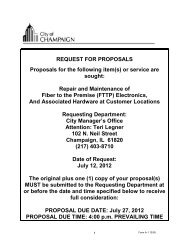
This concept is not new. <strong>The</strong> graphic below<br />
was originally used in the 1950 <strong>Comprehensive</strong><br />
Development <strong>Plan</strong> for <strong>Champaign</strong>-Urbana. It<br />
illustrates the value <strong>of</strong> city planning in ensuring<br />
parks, schools and shops are located within each<br />
neighborhood to create desirable places to live. <strong>The</strong>se<br />
elements should be constructed concurrent to growth.<br />
This simple philosophy can be difficult to implement,<br />
but it is vital to the fiscal, environmental and social<br />
sustainability <strong>of</strong> the <strong>City</strong> <strong>of</strong> <strong>Champaign</strong>.<br />
DRAFT 2-10-11<br />
This graphic from the 1950 <strong>Comprehensive</strong> <strong>Plan</strong> for <strong>Champaign</strong>-Urbana compares<br />
an unplanned neighborhood to a planned neighborhood. It shows the importance <strong>of</strong><br />
having complete neighborhodds with parks, schools and shops near homes.
INTRODUCTION 15<br />
COMPLETE NEIGHBORHOODS<br />
A complete neighborhood is one that includes a variety <strong>of</strong> housing<br />
choices, transit access and urban design features that withstand the<br />
test <strong>of</strong> time. Proximity to schools, parks, shops and services ensures<br />
that residents can meet their daily needs with ease. Logical street,<br />
sidewalk and trail connections provide convenient access to these<br />
amenities from homes, reducing the amount <strong>of</strong> time spent traveling.<br />
Elements <strong>of</strong> a Complete Neighborhood:<br />
•<br />
•<br />
•<br />
Variety <strong>of</strong> housing types, styles<br />
and sizes<br />
Access to transit<br />
Time-tested urban design<br />
•<br />
•<br />
Proximity to parks schools,<br />
shops and services<br />
Connected to amenities by<br />
streets, sidewalks and trails<br />
COMPLETE STREETS<br />
Complete streets provide safe travel facilities for all users including<br />
drivers, pedestrians, transit riders and bicyclists. Not all complete<br />
streets are the same, design standards are tailored to the traffic<br />
volumes <strong>of</strong> each street. For example, a low-traffic street may<br />
accommodate all users without special treatment, while a high-traffic<br />
street may need special markings, such as like bike lanes, to keep all<br />
users safe.<br />
Elements <strong>of</strong> Complete Streets:<br />
• Auto lanes that fit traffic<br />
demand.<br />
• Pedestrian facilities such as<br />
sidewalks and crosswalks<br />
• Bicycle facilities including<br />
bike lanes, lane sharing with<br />
‘sharrows,’ or multi-use trails<br />
• Public transit stops<br />
COMPLETE PUBLIC FACILITIES<br />
Public facilities are essential to the function <strong>of</strong> a community. <strong>The</strong>y<br />
include the physical infrastructure needed to make a community<br />
operate. <strong>The</strong>se include public safety facilities such as fire and police<br />
stations, schools, utilities, parks and transit. When public facilities<br />
are not sufficient, the <strong>City</strong> cannot grow safely and quality <strong>of</strong> life<br />
diminishes.<br />
Elements <strong>of</strong> Complete Public Facilities:<br />
•<br />
•<br />
Police and Fire stations and<br />
equipment located to maintain<br />
adequate response times<br />
Schools<br />
•<br />
•<br />
•<br />
Parks and recreation facilities<br />
Water, sewer and power<br />
facilities and infrastructure<br />
Public transit<br />
DRAFT 2-10-11
16<br />
CHAMPAIGN TOMORROW - COMPREHENSIVE PLAN<br />
DRAFT 2-10-11