Storm Tide Atlas - Southwest Florida Regional Planning Council
Storm Tide Atlas - Southwest Florida Regional Planning Council
Storm Tide Atlas - Southwest Florida Regional Planning Council

You also want an ePaper? Increase the reach of your titles
YUMPU automatically turns print PDFs into web optimized ePapers that Google loves.
Volume VII-9 <strong>Southwest</strong> <strong>Florida</strong><br />
Statewide <strong>Regional</strong> Evacuation Studies Program<br />
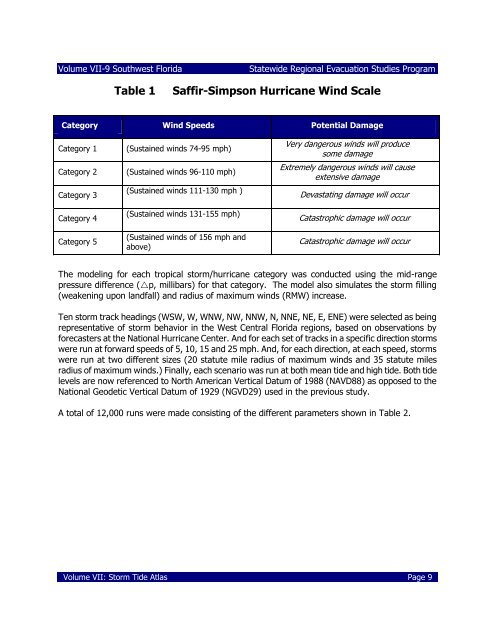
Table 1<br />
Saffir-Simpson Hurricane Wind Scale<br />
Category Wind Speeds Potential Damage<br />
Category 1<br />
Category 2<br />
Category 3<br />
Category 4<br />
Category 5<br />
(Sustained winds 74-95 mph)<br />
(Sustained winds 96-110 mph)<br />
(Sustained winds 111-130 mph )<br />
(Sustained winds 131-155 mph)<br />
(Sustained winds of 156 mph and<br />
above)<br />
Very dangerous winds will produce<br />
some damage<br />
Extremely dangerous winds will cause<br />
extensive damage<br />
Devastating damage will occur<br />
Catastrophic damage will occur<br />
Catastrophic damage will occur<br />
The modeling for each tropical storm/hurricane category was conducted using the mid-range<br />
pressure difference (p, millibars) for that category. The model also simulates the storm filling<br />
(weakening upon landfall) and radius of maximum winds (RMW) increase.<br />
Ten storm track headings (WSW, W, WNW, NW, NNW, N, NNE, NE, E, ENE) were selected as being<br />
representative of storm behavior in the West Central <strong>Florida</strong> regions, based on observations by<br />
forecasters at the National Hurricane Center. And for each set of tracks in a specific direction storms<br />
were run at forward speeds of 5, 10, 15 and 25 mph. And, for each direction, at each speed, storms<br />
were run at two different sizes (20 statute mile radius of maximum winds and 35 statute miles<br />
radius of maximum winds.) Finally, each scenario was run at both mean tide and high tide. Both tide<br />
levels are now referenced to North American Vertical Datum of 1988 (NAVD88) as opposed to the<br />
National Geodetic Vertical Datum of 1929 (NGVD29) used in the previous study.<br />
A total of 12,000 runs were made consisting of the different parameters shown in Table 2.<br />
Volume VII: <strong>Storm</strong> <strong>Tide</strong> <strong>Atlas</strong> Page 9