Storm Tide Atlas - Southwest Florida Regional Planning Council
Storm Tide Atlas - Southwest Florida Regional Planning Council
Storm Tide Atlas - Southwest Florida Regional Planning Council

Create successful ePaper yourself
Turn your PDF publications into a flip-book with our unique Google optimized e-Paper software.
Jack St<br />
Linda St<br />
Keyway Dr<br />
Larry St<br />
Pago Pago Ln<br />
Belle Rd<br />
Unnamed Street<br />
27°1'0"N<br />
21<br />
25<br />
Ocelot Rd<br />
Osprey Rd<br />
Marigold Rd<br />
Hudson St<br />
!( ! 10<br />
Viola Rd<br />
Orchis Rd<br />
Diana Rd<br />
Macon Rd<br />
Alamander Ave<br />
Fessler St<br />
Lemon Ave<br />
Pecan Rd<br />
Belvidere Rd<br />
Gale St<br />
Hudson St<br />
Makins Pl<br />
Fessler St<br />
Larson St<br />
Lemon Ave<br />
7th St<br />
W ater Lily D r<br />
Iris Dr<br />
5th St<br />
6th St<br />
Miami Rd<br />
Heasley Rd<br />
Heasely Rd<br />
8th St<br />
9th St<br />
Caufield Dr<br />
Shell Dr<br />
Venisota Rd<br />
Fossil Dr<br />
Wooded Way<br />
82°24'0"W<br />
Thomas St<br />
Maria St<br />
Oceania Dr<br />
Tonga Ln<br />
5th St<br />
Fiji Cir<br />
Denison Dr<br />
Unnamed Street<br />
Tahiti St<br />
Keyway Rd<br />
Bora Bora Ln<br />
State Road 776<br />
Bridge St<br />
Unnamed Street<br />
28<br />
Li ncoln Rd<br />
Englewood Rd<br />
Harrison Rd<br />
77 77<br />
Ramp<br />
Driveway<br />
Tyler Rd<br />
Overbrook Rd<br />
Pierce Dr<br />
Shane Rd<br />
Owl Dr<br />
Dolphin Dr<br />
5th St<br />
McKinley Rd<br />
Manasota Beach Rd<br />
74 74<br />
Stoner Rd<br />
Keyway Rd<br />
Le Pera Rd<br />
71 71<br />
Ramp<br />
Crest Dr<br />
Wilson Rd<br />
82°23'0"W<br />
Unnamed Street<br />
Driveway<br />
31<br />
Donovan Rd<br />
Keyway Rd<br />
Stout St<br />
Allen St<br />
Unnamed Street<br />
2nd St<br />
Keyway Rd<br />
35<br />
Unnamed Street<br />
Unnamed Street<br />
27°1'0"N<br />
Tangelo Cir<br />
Forked Creek Dr<br />
Manasota Key Rd<br />
27°0'0"N<br />
Bayshore Dr<br />
Chadwick Rd<br />
St Clair Rd<br />
Sarasota COUNTY<br />
Columbia Dr<br />
Bridge St<br />
Driveway<br />
Fox Dr<br />
Highland Ave<br />
Forest Dr<br />
Bridge St<br />
Bridge St<br />
Windsor Dr<br />
Dover Dr<br />
Dover Cir<br />
La rchmont Dr<br />
Fairview Dr<br />
Firetho<br />
Brentwood Dr<br />
Bran d yw<br />
r n Ave<br />
Leawood Rd<br />
Englewood Isles Pkwy<br />
Eden Dr<br />
Woodland Dr<br />
Buereau Rd<br />
Oakwood Dr<br />
Ardenwood Dr<br />
ine Cir<br />
Waterford St<br />
Oakwood Cir<br />
Driveway<br />
Evenintide Dr<br />
Parkway Rd<br />
Marina Plz<br />
Morningside Rd<br />
Granada Plz<br />
Brook Dr<br />
Esplanade St<br />
Hacienda Dr<br />
W h<br />
Whispering Pines Rd<br />
68 68<br />
Barbados Rd<br />
Buena Vista Ave<br />
ispering Pines Cir<br />
Golf Vie w Dr<br />
Englewood Rd<br />
Del Prado Dr<br />
County Road 775<br />
Dominica Dr<br />
27°0'0"N<br />
Lemonwood Dr<br />
Boxwood Ln<br />
9 64<br />
873m.N<br />
26°59'0"N<br />
Gladstone Blvd<br />
Bayshore Dr<br />
Oleander St<br />
Caples St<br />
Lord St<br />
Acacia St<br />
Osceola Rd<br />
Gasparilla Blvd<br />
Gillespi St<br />
Gillespie St<br />
Bay Vista Blvd<br />
Osceola Blvd<br />
Diane Cir<br />
Montana Ave<br />
Old Englewood Rd<br />
Ulrey Ln<br />
Park Place Dr<br />
Iowa Ave<br />
64<br />
26°59'0"N<br />
5<br />
21 960m. E<br />
US National Grid<br />
100,000-m Square ID<br />
LK<br />
Grid Zone Designation<br />
17R<br />
Datum = NAD 1983, 1,000-m USNG<br />
^<br />
GN<br />
#<br />
Diagram<br />
Not to Sc ale<br />
Mag. Declination<br />
4 0 31'W<br />
Changing by<br />
5' W per yr<br />
Date 2009<br />
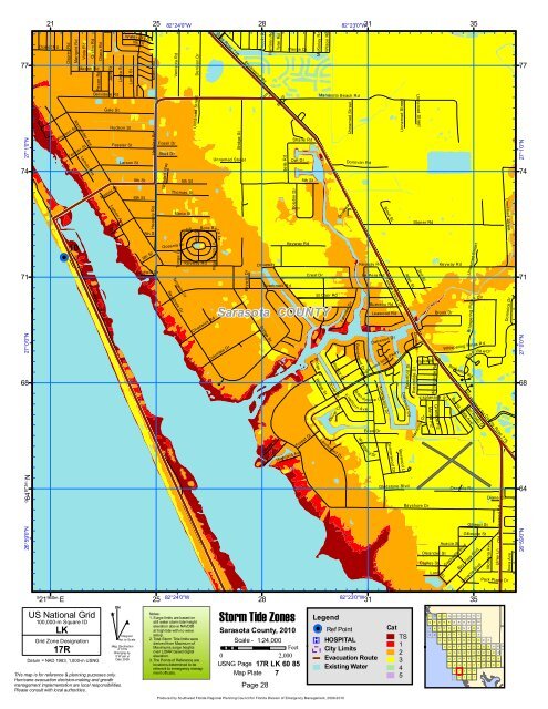
This map is for reference & planning purposes only.<br />
Hurricane evacuation decision-making and growth<br />
management implementation are local responsibilities.<br />
Please consult with local authorities.<br />
25<br />
82°24'0"W<br />
28<br />
<strong>Storm</strong> <strong>Tide</strong> Zones<br />
Sarasota County, 2010<br />
Notes:<br />
1. Surge limits are based on<br />
still water storm tide height<br />
elevation above NAVD88<br />
at high tide with no wave<br />
setup.<br />
2. Total <strong>Storm</strong> <strong>Tide</strong> limits were<br />
derived from Maximum of<br />
Maximums surge heights<br />
over LIDAR based digital<br />
elevation.<br />
3. The Points of Reference are<br />
locations determined to be<br />
relevant to emergency manag-<br />
Scale - 1:24,000<br />
Feet<br />
0 2,000<br />
USNG Page 17R LK 60 85<br />
ment officials. Map Plate 7<br />
Page 28<br />
82°23'0"W<br />
31<br />
Legend<br />
!( ! Ref Point<br />
®v HOSPITAL<br />
City Limits<br />
Evacuation Route<br />
Existing Water<br />
Cat<br />
TS<br />
1<br />
2<br />
3<br />
4<br />
5<br />
35<br />
101 102 103 104 105 106 107 108 109 110 111<br />
90 91 92 93 94 95 96 97 98 99 100<br />
79 80 81 82 83 84 85 86 87 88 89<br />
68 69 70 71 72 73 74 75 76 77 78<br />
57 58 59 60 61 62 63 64 65 66 67<br />
44 45 46 47 48 49 50 51 52 53 54 55 56<br />
33 34 35 36 37 38 39 40 41 42 43<br />
22 23 24 25 26 27 28 29 30 31 32<br />
11 12 13 14 15 16 17 18 19 20 21<br />
6 7 8 9 10<br />
1 2 3 4 5<br />
Produced by <strong>Southwest</strong> <strong>Florida</strong> <strong>Regional</strong> <strong>Planning</strong> <strong>Council</strong> for <strong>Florida</strong> Division of Emergency Management, 2009-2010