Storm Tide Atlas - Southwest Florida Regional Planning Council
Storm Tide Atlas - Southwest Florida Regional Planning Council
Storm Tide Atlas - Southwest Florida Regional Planning Council

Create successful ePaper yourself
Turn your PDF publications into a flip-book with our unique Google optimized e-Paper software.
Kumquat Ct<br />
Osprey Ave<br />
Washington Blvd<br />
East St<br />
Lime Ave<br />
Newtown Blvd<br />
Rhine St<br />
Almond Ave<br />
l<br />
Northgate Ct<br />
East Ave<br />
Ashberry Dr<br />
Driveway<br />
Mango Ave<br />
Snug Harbor Pl<br />
Boyd Ave<br />
Seeds Ave<br />
Chilk Ave<br />
Brazilnut Ave<br />
Avenue D<br />
24th Cir<br />
Forester Oak Ct<br />
82<br />
82°32'0"W<br />
85<br />
82°31'0"W<br />
89<br />
92<br />
82°30'0"W<br />
95<br />
Oakland Hills Ave<br />
Tri Par Dr<br />
Noble St<br />
Orange Ave<br />
Broadmoor St<br />
Palmadelia Ave<br />
Snapper Ln<br />
Presidio St<br />
36th St<br />
35th St<br />
Goodrich Ave<br />
3rd<br />
Maple Ave<br />
10th Way<br />
Fruitville Rd<br />
L<br />
Midlothian St<br />
1st St<br />
Helen Dr<br />
Old Elm St<br />
o nny R d<br />
Desoto Rd<br />
Brookfield Ter<br />
Palm Sp rings St<br />
Olympia Fields St<br />
Indep endence B<br />
Adelia Ave<br />
Gore Ct<br />
Bettina Dr<br />
09 09<br />
27°23'0"N<br />
32nd St<br />
25th St<br />
24th St<br />
23rd St<br />
22nd St<br />
21st St<br />
20th St<br />
Tan geri ne Ln<br />
Unnamed Street<br />
Carver Ct<br />
11th St<br />
25th St<br />
Goodrich Ave<br />
lvd<br />
Church Ave<br />
23rd St<br />
Gregg Ct<br />
9th St<br />
8th St<br />
7th St<br />
34th St<br />
31st St<br />
Links Ave<br />
18th St<br />
Desoto Pkwy<br />
Innisbrook Ln<br />
Woodstock Ln<br />
Cypress Point Ln<br />
Driveway<br />
Osprey Ave<br />
22nd St<br />
24th St<br />
21st St<br />
Osprey Ave<br />
4th St<br />
3rd St 3rd St<br />
Northgate Blvd<br />
34th St<br />
Gillespie Ave<br />
20th St<br />
57th St<br />
Butler Ave<br />
33rd St<br />
32nd St<br />
Gillespie Ave<br />
Dixie Ave<br />
6th St<br />
Sanford Cir<br />
Pershing Ave<br />
Middle Ave<br />
53rd St<br />
57th St<br />
51st St<br />
47th St<br />
Golf Course Dr<br />
£¤ 301 Glouster St<br />
Sarasota COUNTY<br />
Lockwood Lake Cir<br />
25th St<br />
23rd St<br />
22nd St<br />
Bernadette Ln<br />
19th St<br />
Claude Ln<br />
18th St<br />
CITY OF SARASOTA<br />
Bruce Ln<br />
Huron Ln<br />
82°31'0"W<br />
82°30'0"W<br />
Washington Ct<br />
Dr Martin Luther King Jr Way<br />
13th St<br />
Buffalo St<br />
10th St<br />
Ramp<br />
15th St<br />
5th St<br />
Middle Ave<br />
Fruitville Rd<br />
47th St<br />
31st Wa<br />
y<br />
30th St<br />
29th St<br />
28th St<br />
16th St<br />
9th St<br />
Canel<br />
East Ave<br />
Carmichael Ave<br />
Princeton St<br />
Leonard Reid Rd<br />
Harvard St<br />
51st St<br />
13th St<br />
East Ln<br />
4th<br />
6th<br />
Cornell St<br />
2nd<br />
Audubon Pl<br />
Waterloo St<br />
Silver Maple Ct<br />
Seward Cir<br />
Ba nneker Way<br />
King Blvd<br />
Clay Cir<br />
Shade Ave<br />
Dr Martin Luther King Way<br />
Colson Ave<br />
Mango Ave<br />
Apricot Ave<br />
Seward Dr<br />
15th St<br />
Seeds Ave<br />
l Blvd<br />
Industri a<br />
Spring Oaks Cir<br />
Bunche St<br />
20th St<br />
Margaret St<br />
La C osta Cir<br />
Aspinwall St<br />
Ernie Shank Ct<br />
Driveway<br />
Vilas Ave<br />
Erie Ct<br />
Chilk Ave<br />
Bristol Ct<br />
Booker Ave<br />
22nd St<br />
11th St<br />
Jefferson Pnes<br />
10th St<br />
21st St<br />
Euclid Ave<br />
Myrtle St<br />
Stringfield Ave<br />
26th St<br />
Twin Dr<br />
24th St<br />
20th St<br />
Aspinwall St<br />
Oak Park Ave<br />
Tuttle Ave<br />
Coconut Bay Ln<br />
Hid den L ake Dr<br />
Drivew a y<br />
Rolling Green Dr<br />
6th St<br />
Aachen St<br />
Copenhagen St<br />
Allendale Ave<br />
17th St<br />
Edam St<br />
Hague Ave<br />
Guilder St<br />
B O aks Dr<br />
27th Way<br />
Dodge Ave<br />
V<br />
illa<br />
gio Cir<br />
Traylor Ave<br />
49th St<br />
Pittenger Dr<br />
Dutch Ave<br />
Freeman Ave<br />
Reinhard Ave<br />
Voorne St<br />
1st Ct<br />
3rd Ct<br />
Bay Arist ocrat Dr<br />
Rockw ood Cv<br />
Chianti Ct<br />
27th St<br />
Leisur e P<br />
59th St<br />
Lockwood M eadows Blvd<br />
Brink Ave<br />
Brink Ave<br />
Conrad Ave<br />
8th St<br />
42nd St<br />
Mackeral Ave<br />
Locust Ave<br />
44th St<br />
Eden Mills Dr<br />
Conrad Ave<br />
Walnut Ave<br />
40th St<br />
Myrtle Ave<br />
Pompano Ave<br />
Avenue A<br />
Palm Ln<br />
Tarpon Ave<br />
12th St<br />
Lake Ridge Dr<br />
Pompano Ave<br />
Lockwood Ridge Rd<br />
Circl e Dr<br />
Ridge Ave<br />
Glen Elyn Blvd<br />
6th St<br />
East Ave<br />
56th St<br />
Hamlets B<br />
Village Ln<br />
Caruso Pl<br />
51st St<br />
Sunday Ct<br />
Unnamed Street<br />
Randa Blvd<br />
Shiala Ln<br />
Origami Ln<br />
Bailey St<br />
8th St<br />
7th St<br />
lvd<br />
Fauna St<br />
Eagle St<br />
Randa Way<br />
Ramb<br />
Jolson Dr<br />
W<br />
Dante Dr<br />
Yong e Ave<br />
Wolfe Ave<br />
Dudley St<br />
Barstow St<br />
24th Pkwy<br />
Roxane Blvd<br />
Bailey Rd<br />
F o<br />
Ala mo Ln<br />
Murray Pl<br />
inston Ln<br />
Andrea St<br />
lewood Dr<br />
Gershwin Dr<br />
Be e kma n Pl<br />
Fountain Pl<br />
Tallywood Ct<br />
Banchory Ln<br />
Galleon Pl<br />
Heather Pl<br />
Monica Pkwy<br />
Melody Cir<br />
re ster Lake Dr<br />
Dorothy Ave<br />
Ha m<br />
Maple Hammock Dr<br />
lets G<br />
Dover St<br />
Chesh<br />
Bailey Ln<br />
Tallywood Cir<br />
ire Ln<br />
S an Ju<br />
Drymon Ave<br />
Elk Ave<br />
an Dr<br />
rove Dr<br />
Edinbridge Cir<br />
Tobero Ln<br />
Conservatory Dr<br />
05 05<br />
27°22'0"N<br />
Myrtle St<br />
Carmichael Ave<br />
02 02<br />
27°21'0"N<br />
10 92<br />
825m.N<br />
19th St<br />
4th St<br />
33rd St<br />
32nd St<br />
5th St<br />
Gillespie Ave<br />
82°32'0"W<br />
4<br />
82 590m. E<br />
Unnamed Street<br />
19th St<br />
20th St<br />
19th St<br />
East St<br />
Mango Ave<br />
3rd St<br />
25th St<br />
6th St<br />
85<br />
S h ade Ave<br />
8<br />
t<br />
th S<br />
24th St<br />
Driveway<br />
Driveway<br />
22nd St<br />
5th St<br />
89<br />
10th St<br />
6th St<br />
Edam St<br />
Brink Ave<br />
Brazilnut Ave<br />
Aspinwall St<br />
Pompano Ave<br />
Tarpon Ave<br />
92<br />
Driveway<br />
6th St<br />
D riveway<br />
Capitan Ave<br />
Gocio Rd<br />
Ingot Pl<br />
27th Pkwy<br />
Fern Ave<br />
Jay Pl<br />
Schwalbe Dr<br />
Oriente Ave<br />
Beneva Rd<br />
Gold Ave<br />
Angel e<br />
Big Pine Rd<br />
s Ave<br />
Ventura Ave<br />
Hidden Forest Ln<br />
Branch Creek Dr<br />
Prado Dr<br />
Prudence Dr<br />
Harley Ave<br />
Drive way<br />
Kilgore Pl<br />
Ivy Pl<br />
Mala g a Ave<br />
Lost Forest Rd<br />
Lench Pl<br />
Circus Blvd<br />
Hidden Fore s<br />
Milton Ave<br />
Melgert Pl<br />
Dover Dr<br />
Calliandra Dr<br />
t Dr<br />
Quiet Pond Ln<br />
Pond View Ln<br />
99 99<br />
96 96<br />
US National Grid<br />
100,000-m Square ID<br />
LL<br />
Grid Zone Designation<br />
17R<br />
Datum = NAD 1983, 1,000-m USNG<br />
^<br />
GN<br />
#<br />
Diagram<br />
Not to Sc ale<br />
Mag. Declination<br />
4 0 31'W<br />
Changing by<br />
5' W per yr<br />
Date 2009<br />
This map is for reference & planning purposes only.<br />
Hurricane evacuation decision-making and growth<br />
management implementation are local responsibilities.<br />
Please consult with local authorities.<br />
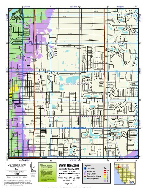
<strong>Storm</strong> <strong>Tide</strong> Zones<br />
Sarasota County, 2010<br />
Notes:<br />
1. Surge limits are based on<br />
still water storm tide height<br />
elevation above NAVD88<br />
at high tide with no wave<br />
setup.<br />
2. Total <strong>Storm</strong> <strong>Tide</strong> limits were<br />
derived from Maximum of<br />
Maximums surge heights<br />
over LIDAR based digital<br />
elevation.<br />
3. The Points of Reference are<br />
locations determined to be<br />
relevant to emergency manag-<br />
Scale - 1:24,000<br />
Feet<br />
0 2,000<br />
USNG Page 17R LL 48 25<br />
ment officials. Map Plate 93<br />
Page 99<br />
Produced by <strong>Southwest</strong> <strong>Florida</strong> <strong>Regional</strong> <strong>Planning</strong> <strong>Council</strong> for <strong>Florida</strong> Division of Emergency Management, 2009-2010<br />
Legend<br />
!( ! Ref Point<br />
®v HOSPITAL<br />
City Limits<br />
Evacuation Route<br />
Existing Water<br />
Cat<br />
TS<br />
1<br />
2<br />
3<br />
4<br />
5<br />
101<br />
90<br />
79<br />
68<br />
102<br />
91<br />
80<br />
69<br />
103<br />
92<br />
81<br />
70<br />
57<br />
104<br />
93<br />
82<br />
71<br />
58<br />
44<br />
105<br />
94<br />
83<br />
72<br />
59<br />
45<br />
33<br />
22<br />
11<br />
106<br />
95<br />
84<br />
73<br />
60<br />
46<br />
34<br />
23<br />
12<br />
6<br />
1<br />
107<br />
96<br />
85<br />
74<br />
61<br />
47<br />
35<br />
24<br />
13<br />
7<br />
2<br />
108<br />
97<br />
86<br />
75<br />
62<br />
48<br />
36<br />
25<br />
14<br />
8<br />
3<br />
109<br />
98<br />
87<br />
76<br />
63<br />
49<br />
37<br />
26<br />
15<br />
9<br />
4<br />
110<br />
99<br />
88<br />
77<br />
64<br />
50<br />
38<br />
27<br />
16<br />
10<br />
5<br />
111<br />
100<br />
89<br />
78<br />
65<br />
51<br />
39<br />
28<br />
17<br />
66<br />
52<br />
40<br />
29<br />
18<br />
University Pl<br />
Pin Oaks St<br />
Allenwood St<br />
Breezemont Dr<br />
67<br />
53<br />
41<br />
30<br />
19<br />
54<br />
42<br />
31<br />
20<br />
55<br />
Colby St<br />
43<br />
32<br />
21<br />
56<br />
95<br />
27°23'0"N<br />
27°22'0"N<br />
27°21'0"N<br />
92