Storm Tide Atlas - Southwest Florida Regional Planning Council
Storm Tide Atlas - Southwest Florida Regional Planning Council
Storm Tide Atlas - Southwest Florida Regional Planning Council

Create successful ePaper yourself
Turn your PDF publications into a flip-book with our unique Google optimized e-Paper software.
82°20'0"W<br />
48<br />
51<br />
82°19'0"W<br />
54<br />
58<br />
82°18'0"W<br />
61<br />
Unnamed Street<br />
Fox Ln<br />
Snook Ln<br />
M<br />
My ak k a Blvd<br />
94 94<br />
isty Ln<br />
P a<br />
l m Pl<br />
Hawk Hvn<br />
Do ugl a ss Dr<br />
27°4'0"N<br />
27°4'0"N<br />
91 91<br />
87 87<br />
27°3'0"N<br />
Tamiami Trl<br />
Sarasota COUNTY<br />
27°3'0"N<br />
£¤ 41 UV 45 82°18'0"W<br />
Driveway<br />
Unnamed Street<br />
£¤ 41<br />
Tamiami Trl<br />
84 84<br />
River Rd<br />
Ramp<br />
M yakka<br />
!( ! 13<br />
Myakk a<br />
P<br />
laymore Dr<br />
Myakka Dr<br />
County Road 777<br />
Unnamed Street<br />
Edward A ve<br />
9 81 27°2'0"N 277m.N<br />
CITY OF NORTH PORT<br />
27°2'0"N<br />
81<br />
County Hwy 777<br />
82°20'0"W<br />
5<br />
48 207m. E<br />
US National Grid<br />
100,000-m Square ID<br />
LK<br />
Grid Zone Designation<br />
17R<br />
Datum = NAD 1983, 1,000-m USNG<br />
^<br />
GN<br />
#<br />
Diagram<br />
Not to Sc ale<br />
Mag. Declination<br />
4 0 31'W<br />
Changing by<br />
5' W per yr<br />
Date 2009<br />
This map is for reference & planning purposes only.<br />
Hurricane evacuation decision-making and growth<br />
management implementation are local responsibilities.<br />
Please consult with local authorities.<br />
51<br />
82°19'0"W<br />
54<br />
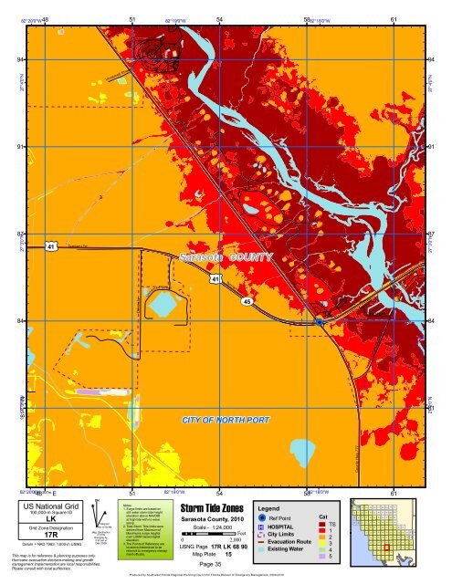
<strong>Storm</strong> <strong>Tide</strong> Zones<br />
Sarasota County, 2010<br />
Notes:<br />
1. Surge limits are based on<br />
still water storm tide height<br />
elevation above NAVD88<br />
at high tide with no wave<br />
setup.<br />
2. Total <strong>Storm</strong> <strong>Tide</strong> limits were<br />
derived from Maximum of<br />
Maximums surge heights<br />
over LIDAR based digital<br />
elevation.<br />
3. The Points of Reference are<br />
locations determined to be<br />
relevant to emergency manag-<br />
Scale - 1:24,000<br />
Feet<br />
0 2,000<br />
USNG Page 17R LK 68 90<br />
ment officials. Map Plate 15<br />
Page 35<br />
58<br />
Legend<br />
!( ! Ref Point<br />
®v HOSPITAL<br />
City Limits<br />
Evacuation Route<br />
Existing Water<br />
Cat<br />
TS<br />
1<br />
2<br />
3<br />
4<br />
5<br />
61<br />
101 102 103 104 105 106 107 108 109 110 111<br />
90 91 92 93 94 95 96 97 98 99 100<br />
79 80 81 82 83 84 85 86 87 88 89<br />
68 69 70 71 72 73 74 75 76 77 78<br />
57 58 59 60 61 62 63 64 65 66 67<br />
44 45 46 47 48 49 50 51 52 53 54 55 56<br />
33 34 35 36 37 38 39 40 41 42 43<br />
22 23 24 25 26 27 28 29 30 31 32<br />
11 12 13 14 15 16 17 18 19 20 21<br />
6 7 8 9 10<br />
1 2 3 4 5<br />
Produced by <strong>Southwest</strong> <strong>Florida</strong> <strong>Regional</strong> <strong>Planning</strong> <strong>Council</strong> for <strong>Florida</strong> Division of Emergency Management, 2009-2010