Storm Tide Atlas - Southwest Florida Regional Planning Council
Storm Tide Atlas - Southwest Florida Regional Planning Council
Storm Tide Atlas - Southwest Florida Regional Planning Council

You also want an ePaper? Increase the reach of your titles
YUMPU automatically turns print PDFs into web optimized ePapers that Google loves.
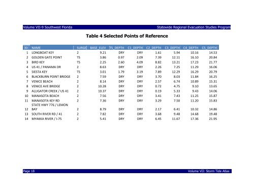
Volume VII-9 <strong>Southwest</strong> <strong>Florida</strong><br />
Statewide <strong>Regional</strong> Evacuation Studies Program<br />
Table 4 Selected Points of Reference<br />
ID NAME SURGE BASE_ELEV TS_DEPTH C1_DEPTH C2_DEPTH C3_DEPTH C4_DEPTH C5_DEPTH<br />
1 LONGBOAT KEY 2 9.21 DRY DRY 1.61 5.94 10.16 14.53<br />
2 GOLDEN GATE POINT TS 3.86 0.97 2.09 7.39 12.11 16.10 20.84<br />
3 BIRD KEY TS 2.25 2.60 4.09 8.82 13.21 17.23 21.77<br />
4 US 41 / PANAMA DR 2 8.63 DRY DRY 2.26 7.25 11.29 16.06<br />
5 SIESTA KEY TS 3.01 1.79 3.19 7.89 12.29 16.29 20.79<br />
6 BLACKBURN POINT BRIDGE 2 7.59 DRY DRY 3.70 8.03 11.84 16.25<br />
7 VENICE BEACH 2 8.14 DRY DRY 2.57 6.74 10.89 15.31<br />
8 VENICE AVE BRIDGE 2 10.28 DRY DRY 0.72 4.75 9.10 13.65<br />
9 ALLIGATOR CREEK / US 41 2 10.37 DRY DRY 0.19 5.33 9.43 14.06<br />
10 MANASOTA BEACH 2 7.56 DRY DRY 3.41 7.43 11.25 15.87<br />
11 MANASOTA KEY RD 2 7.36 DRY DRY 3.29 7.50 11.20 15.83<br />
12<br />
STATE HWY 776 / LEMON<br />
BAY 2 8.79 DRY DRY 2.17 6.41 10.32 14.86<br />
13 SOUTH RIVER RD / 41 2 7.82 DRY DRY 3.68 9.48 14.68 19.48<br />
14 MYAKKA RIVER / I-75 2 5.41 DRY DRY 6.45 11.67 17.36 21.95<br />
Page 18<br />
Volume VII: <strong>Storm</strong> <strong>Tide</strong> <strong>Atlas</strong>