
Create successful ePaper yourself
Turn your PDF publications into a flip-book with our unique Google optimized e-Paper software.
San Francisco County<br />
Planning for infill development<br />
General Assessment<br />
The City and County of San<br />
Francisco does not possess any<br />
threatened greenbelt land, but it has<br />
an important role to play in protecting<br />
regional open space and improving<br />
the Bay Area’s overall growth<br />
patterns. To fulfill its role as a center<br />
city and a major job center, San<br />
Francisco must continue expanding<br />
its recent initiatives to encourage<br />
livable and affordable infill growth.<br />
Hot Spots<br />
There is no at-risk acreage within the<br />
City and County of San Francisco.<br />
San Francisco’s challenge is in<br />
creating homes that local workers<br />
can afford. Housing prices are out<br />
of reach for many families, who are<br />
forced to look for homes in distant<br />
areas; this contributes to sprawl<br />
development, traffic congestion, and<br />
loss of greenbelt lands throughout<br />
the Bay Area.<br />
Bright Spots<br />
Since 2000, San Francisco has<br />
pursued several important planning<br />
initiatives to encourage new construction<br />
in particular areas of the<br />
city, especially around transit.<br />
cation. The City has also embarked<br />
upon a Downtown Neighborhoods<br />
Initiative to house as many as 40,000<br />
new residents downtown. The City<br />
has finished the Rincon Hill Plan to<br />
bring high-density housing and<br />
commercial space to the area just<br />
west of the foot of the Bay Bridge,<br />
within walking distance of downtown<br />
San Francisco. This plan,<br />
endorsed by <strong>Greenbelt</strong> <strong>Alliance</strong>, is<br />
the first new neighborhood plan<br />
approved by the Planning<br />
Commission in over a decade.<br />
The Mission Bay redevelopment,<br />
whose plan was long ago endorsed by<br />
<strong>Greenbelt</strong> <strong>Alliance</strong> and has now<br />
come into fruition as a project, has<br />
completed a considerable amount of<br />
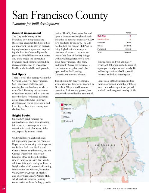
High <strong>Risk</strong><br />
Medium <strong>Risk</strong><br />
Low <strong>Risk</strong><br />
Urban<br />
Protected<br />
construction, and will ultimately<br />
create 6,000 homes, with 49 acres of<br />
open space and parks, and nearly 10<br />
million square feet of office, retail,<br />
research and educational space.<br />
Large-scale infill developments like<br />
these, near transit and jobs, will help<br />
to accommodate significant growth<br />
and add to the region’s quality of life.<br />
101<br />
Acres<br />
High <strong>Risk</strong> 0<br />
Medium <strong>Risk</strong> 0<br />
Low <strong>Risk</strong> 600<br />
Urban 24,900<br />
Protected 5,100<br />
Total 30,600<br />
Under its Better Neighborhoods<br />
2002 planning process, the Planning<br />
Department is working on area plans<br />
for Balboa Park, the Market and<br />
Octavia Street neighborhood, and the<br />
Central Waterfront to increase<br />
housing, office and retail construction<br />
in these transit-rich districts. In<br />
addition, it is undertaking an Eastern<br />
Neighborhoods Community Planning<br />
Initiative for the Mission, Visitacion<br />
Valley, Bayview, South of Market,<br />
and Showplace Square/Potrero Hill,<br />
which seeks to increase housing<br />
construction without fueling gentrifi-<br />
1 Mile<br />
kN<br />
1<br />
S a n F r a n c i s c o<br />
280<br />
22<br />
<strong>At</strong> <strong>Risk</strong>: The Bay Area <strong>Greenbelt</strong>