Create successful ePaper yourself
Turn your PDF publications into a flip-book with our unique Google optimized e-Paper software.
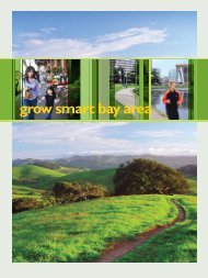
Executive Summary<br />
One in 10 Bay Area acres at risk of sprawl development<br />
The Bay Area is a great place to live.<br />
Its landscapes are spectacular, its<br />
cities diverse and vibrant, and its<br />
economy strong.<br />
The Bay Area is also facing a major<br />
challenge: how to deal with growth<br />
in a way that preserves the region’s<br />
high quality of life.<br />
This region is famous for being a<br />
major metropolitan area surrounded<br />
by a thriving greenbelt of forests,<br />
coastlines, fields, and orchards. In<br />
many ways, the Bay Area has done<br />
well at navigating the challenges of<br />
growth, keeping development off<br />
hillsides and protecting the fertile<br />
farmlands that surround our cities.<br />
But the Bay Area’s greenbelt is at risk.<br />
It is threatened by sprawl: low-density<br />
suburban development on the region’s<br />
fringe. This poorly planned development<br />
paves open space, worsens air<br />
and water quality, and exacerbates<br />
housing and transportation problems.<br />
<strong>Greenbelt</strong> <strong>Alliance</strong>, the Bay Area’s<br />
land conservation and urban planning<br />
organization, analyzed the state of<br />
the region’s landscapes in 2005. This<br />
landmark study determined that today,<br />
there are 401,500 acres of greenbelt<br />
lands at risk of sprawl development.<br />
That includes 125,200 acres at risk<br />
within the next 10 years, classified as<br />
high-risk land, and 276,200 acres at<br />
risk within the next 30 years, classified<br />
as medium-risk land.<br />
The Good News<br />
This is an improvement: the total<br />
amount of Bay Area land at risk of<br />
sprawl development has declined by<br />
13% since 2000, when it was<br />
464,100 acres. The amount of land at<br />
high risk has decreased by 41% since<br />
2000. This progress is largely a result<br />
of better planning and land-use<br />
policies, especially the widespread<br />
use of urban growth boundaries.<br />
Today, 1,007,200 acres of greenbelt<br />
lands are permanently protected<br />
from development, a 27% increase<br />
since 2000. This represents acquisitions<br />
by land trusts and state parks,<br />
as well as conservation easements<br />
(the sale of development rights for<br />
conservation purposes).<br />
The Bad News<br />
Though the Bay Area has made real<br />
progress, 401,500 acres at risk of<br />
sprawl development is still an<br />
enormous amount of land: the size of<br />
13 San Franciscos.<br />
Regionally, nearly 1 out of every<br />
10 acres of land in the entire Bay<br />
Area is at risk. In Solano and Contra<br />
Costa Counties, almost 1 out of every<br />
5 acres is at risk.<br />
If all the lands at risk were developed,<br />
Solano, Napa, and Sonoma Counties’<br />
urbanized areas would more than<br />
double. Overall, the region’s urbanized<br />
area would balloon to over one<br />
and a half times its current size of<br />
761,400 acres, with devastating effects<br />
for the Bay Area’s environment and<br />
economy.<br />
Another troubling trend is that<br />
medium-risk land—land at risk of<br />
sprawl development in 10 to 30<br />
years—is on the rise. It has increased<br />
by 10% since 2000. This is partly<br />
due to land parcelization, where land<br />
that appears whole has actually<br />
already been cut up into small lots.<br />
This could allow thousands of new<br />
houses to spring up in rural areas.<br />
Challenges for<br />
Every County<br />
Around the region, the places at<br />
highest risk—the sprawl hot spots—<br />
include the I-80 corridor in Solano<br />
County, the eastern cities in Contra<br />
Costa County, Coyote Valley in<br />
southern Santa Clara County, the<br />
Tri‐Valley area of Alameda and<br />
Contra Costa Counties, and areas<br />
along Highway 101 through Sonoma<br />
County.<br />
Solano County now has the most<br />
land at risk in the Bay Area. Sonoma,<br />
Contra Costa, and Santa Clara also<br />
have large amounts of land at risk.<br />
Land-use decisions in these four<br />
counties will have major consequences<br />
for the entire region.<br />
Counties that have less land at risk,<br />
especially Marin, San Mateo, and<br />
San Francisco, still have a crucial role<br />
to play in regional greenbelt protection.<br />
If the Bay Area is to accommodate<br />
growth sustainably, the<br />
region’s cities and counties must<br />
work together to focus development<br />
in existing urbanized areas and to<br />
improve transit access and housing<br />
affordability. Policymakers, regional<br />
and local planning agencies, organizations<br />
like <strong>Greenbelt</strong> <strong>Alliance</strong>, and<br />
Bay Area residents will play a critical<br />
role in this process.<br />
Looking Ahead<br />
The Bay Area will continue to grow,<br />
and grow rapidly. In recent years, the<br />
region has done well at adopting<br />
policies to guide better growth. As<br />
development pressures increase, so<br />
will the challenges. It will be up to<br />
Bay Area residents and elected<br />
leaders to make the right decisions<br />
to ensure a vibrant, healthy region.<br />
<br />
<strong>At</strong> <strong>Risk</strong>: The Bay Area <strong>Greenbelt</strong>