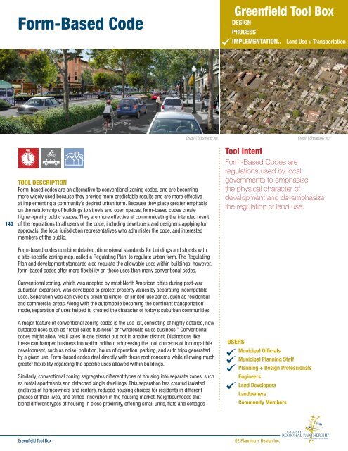
Form-Based Code - The Greenfield Tool Box
Form-Based Code - The Greenfield Tool Box
Form-Based Code - The Greenfield Tool Box

You also want an ePaper? Increase the reach of your titles
YUMPU automatically turns print PDFs into web optimized ePapers that Google loves.
<strong>Form</strong>-<strong>Based</strong> <strong>Code</strong><br />
<strong>Greenfield</strong> <strong>Tool</strong> <strong>Box</strong><br />
DESIGN<br />
PROCESS<br />
IMPLEMENTATION.. Land Use + Transportation<br />
140<br />
Credit | Urbsworks Inc.<br />
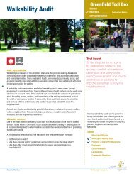
TOOL DESCRIPTION<br />
<strong>Form</strong>-based codes are an alternative to conventional zoning codes, and are becoming<br />
more widely used because they provide more predictable results and are more effective<br />
at implementing a community’s desired urban form. Because they place greater emphasis<br />
on the relationship of buildings to streets and open spaces, form-based codes create<br />
higher-quality public spaces. <strong>The</strong>y are more effective at communicating the intended result<br />
of the regulations to all users of the code, including developers and designers applying for<br />
approvals, the local jurisdiction representatives who administer the code, and interested<br />
members of the public.<br />
<strong>Form</strong>-based codes combine detailed, dimensional standards for buildings and streets with<br />
a site-specific zoning map, called a Regulating Plan, to regulate urban form. <strong>The</strong> Regulating<br />
Plan and development standards also regulate the allowable uses within buildings; however,<br />
form-based codes offer more flexibility on these uses than many conventional codes.<br />
Conventional zoning, which was adopted by most North American cities during post-war<br />
suburban expansion, was developed to protect property values by separating incompatible<br />
uses. Separation was achieved by creating single- or limited-use zones, such as residential<br />
and commercial areas. Along with the automobile becoming the dominant transportation<br />
mode, separation of uses helped to created the character of today’s suburban communities.<br />
A major feature of conventional zoning codes is the use list, consisting of highly detailed, now<br />
outdated uses such as “retail sales business” or “wholesale sales business.” Conventional<br />
codes might allow retail sales in one district but not in another district. Distinctions like<br />
these can hamper business innovation without addressing the root concerns of incompatible<br />
development, such as noise, pollution, hours of operation, parking, and auto trips generated<br />
by a given use. <strong>Form</strong>-based codes deal directly with these root concerns while allowing much<br />
greater flexibility regarding the specific uses allowed within buildings.<br />
Similarly, conventional zoning segregates different types of housing into separate zones, such<br />
as rental apartments and detached single dwellings. This separation has created isolated<br />
enclaves of homeowners and renters, reduced housing choices for residents in different<br />
phases of their lives, and stifled innovation in the housing market. Neighbourhoods that<br />
blend different types of housing in close proximity, offering small units, flats and cottages<br />
<strong>Tool</strong> Intent<br />
<strong>Form</strong>-<strong>Based</strong> <strong>Code</strong>s are<br />
regulations used by local<br />
governments to emphasize<br />
the physical character of<br />
development and de-emphasize<br />
the regulation of land use.<br />
USERS<br />
Municipal Officials<br />
Municipal Planning Staff<br />
Planning + Design Professionals<br />
Engineers<br />
Land Developers<br />
Landowners<br />
Community Members<br />
Credit | Urbsworks Inc.<br />
<strong>Greenfield</strong> <strong>Tool</strong> <strong>Box</strong><br />
O2 Planning + Design Inc.
13<br />
12<br />
NW CROSSING DRIVE<br />
SUMMIT<br />
HIGH SCHOOL<br />
11<br />
10<br />
9<br />
8<br />
1<br />
DISCOVERY<br />
PARK<br />
13<br />
7<br />
2<br />
11<br />
12<br />
3<br />
4<br />
15 14<br />
6<br />
16<br />
1<br />
10<br />
5<br />
9<br />
5<br />
6<br />
159<br />
158<br />
157<br />
23<br />
22 85<br />
SACAGAWEA LANE<br />
21 84 71 70<br />
20<br />
19 83 72 69<br />
68<br />
82 73<br />
17<br />
18<br />
67<br />
16 81 74<br />
15 80 75<br />
66<br />
79 76 65<br />
12<br />
78 77 64<br />
HIGH LAKES<br />
COLTER AVE.<br />
ELEMENTARY<br />
10 11 62 51 50<br />
SCHOOL<br />
9 61 52 49<br />
8 60 53 48<br />
7 59 54 47<br />
6<br />
58 55 46<br />
5 57 56 45<br />
HIGH LAKES LOOP<br />
4<br />
32 33 34 35 36 37 38 39 40 41 42 43 44<br />
3<br />
14<br />
13<br />
156<br />
2<br />
1<br />
8 7<br />
4<br />
17<br />
24<br />
162 164 166<br />
163 165<br />
SHIELDS DR.<br />
149 148 136<br />
150 147 137<br />
146 138<br />
151<br />
145 139<br />
152<br />
144 140<br />
153<br />
143 141<br />
128<br />
155 154<br />
130 129<br />
BRATTON LN.<br />
115-D 116 117 118 119 120<br />
114-D 113 112 111 110 109<br />
88-D<br />
87<br />
86<br />
30 29 28<br />
385<br />
2 1<br />
3<br />
4<br />
5<br />
6<br />
3<br />
7<br />
8<br />
594<br />
108 107 106 105 104 103 102 101100<br />
90 91 92 93 94 95 96 97 98 99<br />
27 26 25 24 23<br />
2<br />
167<br />
3 4 5 6<br />
365<br />
366<br />
384<br />
383<br />
382<br />
381<br />
387<br />
388<br />
389<br />
390<br />
404<br />
403<br />
402<br />
401<br />
407<br />
408<br />
409<br />
168<br />
ORDWAY AVE.<br />
NW CROSSING DRIVE<br />
596 597 598<br />
135<br />
134<br />
133<br />
132<br />
131<br />
127<br />
126<br />
125<br />
124<br />
123<br />
122<br />
121<br />
169 170 171 172 173 174 175 176 177 178<br />
217<br />
218<br />
219<br />
220<br />
221<br />
222<br />
223<br />
224<br />
225<br />
226<br />
227<br />
228<br />
229<br />
230<br />
231<br />
232<br />
233<br />
234<br />
22 21 20 19 18 17<br />
1<br />
234567<br />
8<br />
910<br />
11<br />
380<br />
379<br />
378<br />
377<br />
376<br />
391<br />
400<br />
392<br />
393<br />
394<br />
395<br />
399<br />
398<br />
397<br />
216<br />
16<br />
15<br />
197<br />
198<br />
199<br />
200<br />
201<br />
202<br />
203<br />
204<br />
196<br />
195<br />
194<br />
179<br />
193<br />
POMPY 205 192<br />
206<br />
207 191<br />
LEWIS 208 190<br />
209<br />
&<br />
210 189<br />
CLARK 211<br />
212 188<br />
PARK 213 187<br />
214 186<br />
LEMHI PASS DRIVE<br />
235 236 237 238<br />
396<br />
242 241 240<br />
12<br />
13<br />
14<br />
15<br />
30<br />
29<br />
28<br />
27<br />
26<br />
25<br />
24<br />
23<br />
22<br />
21<br />
20<br />
19<br />
18<br />
17<br />
16<br />
239<br />
243<br />
463<br />
462<br />
461<br />
460<br />
459<br />
458<br />
457<br />
45<br />
443<br />
42<br />
47<br />
41<br />
439<br />
48<br />
438<br />
437<br />
450<br />
436<br />
410<br />
411<br />
412<br />
413<br />
414<br />
415<br />
416<br />
417<br />
418<br />
419<br />
420<br />
421<br />
603<br />
604<br />
629 630<br />
605<br />
628 631 641<br />
606<br />
627 632 642<br />
607<br />
626 633<br />
608<br />
643<br />
625 634<br />
624<br />
615<br />
635<br />
614<br />
613 623<br />
616<br />
622<br />
621<br />
620<br />
2 617 618 619<br />
659<br />
602<br />
601<br />
600<br />
599<br />
609<br />
610<br />
611<br />
612<br />
653<br />
654<br />
655<br />
656<br />
657<br />
658<br />
40<br />
372<br />
371<br />
HIGH LAKES LOOP<br />
.<br />
300<br />
451<br />
435<br />
4 3<br />
434<br />
453<br />
429<br />
428<br />
427<br />
426<br />
425<br />
424<br />
180<br />
181<br />
182<br />
183<br />
184<br />
185<br />
255<br />
254<br />
253<br />
252<br />
251<br />
250<br />
256<br />
257<br />
258<br />
259<br />
260<br />
261<br />
283<br />
282<br />
281<br />
280<br />
279<br />
244<br />
245<br />
246<br />
247<br />
284<br />
285<br />
286<br />
287<br />
301<br />
302<br />
303<br />
304<br />
305<br />
306<br />
307<br />
308<br />
309<br />
432<br />
456<br />
455<br />
454<br />
COMPASS PARK<br />
431<br />
430<br />
423<br />
422<br />
7<br />
464<br />
465<br />
466<br />
467<br />
278<br />
277<br />
276<br />
310<br />
311<br />
312<br />
313<br />
486<br />
485<br />
484<br />
483<br />
482<br />
481<br />
480<br />
525<br />
526<br />
527<br />
528<br />
First Lutheran<br />
Church<br />
341<br />
342 343<br />
275<br />
274<br />
273<br />
272<br />
334 335 336 325 337 338<br />
339<br />
324<br />
340<br />
323<br />
550 551552553<br />
554<br />
555<br />
556<br />
535 536<br />
537<br />
538<br />
539<br />
540<br />
577<br />
8<br />
578<br />
11<br />
9<br />
12<br />
13<br />
6<br />
10<br />
14<br />
5<br />
LABICHE LANE<br />
571<br />
572<br />
17<br />
16<br />
15<br />
314<br />
315<br />
316<br />
317<br />
318<br />
352<br />
345<br />
351<br />
346<br />
350 349348347<br />
557<br />
558<br />
582<br />
581<br />
580<br />
579<br />
2<br />
1<br />
559<br />
560<br />
4 8<br />
487<br />
2<br />
1<br />
271<br />
270<br />
321 320<br />
686<br />
687<br />
4<br />
3<br />
319<br />
6<br />
5<br />
705<br />
704<br />
703<br />
702<br />
8<br />
7<br />
14<br />
13<br />
706<br />
707<br />
505<br />
708<br />
709<br />
479<br />
685 688<br />
701 711<br />
684 689 700 712<br />
529 593 683 690 699 713<br />
561<br />
682 691 698 714<br />
468 562 591 681 692 697 715<br />
469 563 590 680<br />
470 564 589 679 693 694 695 696<br />
DROUILLARD AVENUE<br />
471 565 588<br />
472 566<br />
587<br />
473 567<br />
568 586<br />
569<br />
570<br />
585<br />
584<br />
583<br />
9<br />
710<br />
Available Custom Home Lots<br />
Available Multi-Family Lots<br />
Townhomes<br />
Mt. Washington Cottages<br />
Residential<br />
Multi-Family<br />
Mixed Use/Live-Work<br />
Commercial<br />
Mixed Employment<br />
Industrial Employment Overlay<br />
Note: This is not a survey of the land.<br />
Map indicates lots listed by <strong>The</strong> Garner Group Realtors and Development LLC<br />
including those owned by West Bend Property Co.<br />
This map is solely distributed by <strong>The</strong> Garner Group Realtors and Development LLC and West Bend Property Co. © 2011<br />
Revised 7/28/11<br />
<strong>Form</strong>-<strong>Based</strong> <strong>Code</strong><br />
near conventional detached single dwellings, and rental housing near owner-occupied<br />
housing, offer more options for a changing population. This is especially important with<br />
major demographic changes, such as smaller household sizes, aging baby-boomers, and<br />
the future wave of homebuyers and renters of Generation Y who will continue to push for<br />
smaller, more affordable units, both for rent and for sale, in walkable areas with affordable<br />
transportation choices. Communities that are able to allow Baby Boomers to age in place<br />
and downsize while remaining in their long-time neighbourhood, for example, will fare better<br />
than segregated single-use housing districts. <strong>Form</strong>-based codes also excel at maintaining the<br />
desired look and feel of a residential neighbourhood, while allowing a much wider range of<br />
housing choices.<br />
Compared with conventional codes, form-based codes also allow greater innovation and<br />
flexibility for homebuilders. Housing types and arrangements are the product of creative<br />
entrepreneurs appealing to consumer tastes in response to changing demographic trends<br />
and economic conditions. As allowed by local codes, housing design will increasingly blur the<br />
line between what is built in multi-family zones and what is built in single-family zones, and<br />
between what is sold and what is rented.<br />
A third distinction between form-based codes and conventional codes is the way they<br />
integrate the design of private development and public areas. Conventional zoning<br />
ordinances deal with private development, but typically do not include standards for the<br />
design or character of the streets that serve it. <strong>The</strong>se standards are usually left to engineers<br />
or public works departments. As a result, street standards are normally created with a<br />
distinct deference to accommodating automobile traffic. <strong>The</strong>y are based on general street<br />
classification (arterial, collector, local) with no special consideration of how these standards<br />
relate to the different areas the streets serve. For example, it is common for an arterial street<br />
to have the same design as it travels through employment, commercial, and residential<br />
districts in a city. This general application of development and street standards does not<br />
allow zoning ordinances to promote development envisioned by community plans. In fact,<br />
conventional zoning regulations often undermine the very plans they are supposed to support.<br />
Critical components of the form-based code include:<br />
› <strong>The</strong> Regulating Plan<br />
› A Development Standards Table<br />
› Easy-to-understand graphics and tables used to array the Development Standards (note<br />
that form-based codes emphasize illustrations over text)<br />
Benefits<br />
<strong>Form</strong>-based codes have many advantages over conventional codes. Among other<br />
characteristics:<br />
› <strong>The</strong>y are the result of a public design process, which creates a clear and articulate vision<br />
for a defined district or neighbourhood.<br />
› By encouraging active public participation in creating the Regulating Plan and related<br />
design elements, form-based codes build consensus at the beginning of the process,<br />
thereby reducing misunderstanding and conflict during implementation.<br />
› <strong>The</strong>y focus on what the community likes and not what it dislikes, making it easier for<br />
developers, citizens, and decision-makers to find common ground when individual<br />
development projects are proposed.<br />
› <strong>The</strong>y pay greater attention to the design of the public realm and the importance that<br />
streetscape design and individual building character have in defining public spaces and a<br />
special sense of place.<br />
› Development standards are tailored to fit a specific place by reflecting its vernacular<br />
architecture and overall character; therefore, form-based codes work better than<br />
conventional codes in helping communities retain and strengthen their identity.<br />
CASE STUDIES | BEST PRACTICES<br />
NorthWest Crossing <strong>Form</strong>-<strong>Based</strong> <strong>Code</strong><br />
DISCOVERY LOOP<br />
CHARBONNEAU ST.<br />
DISCOVERY LOOP<br />
YORK ST.<br />
NW CLEARWATER DR.<br />
MT. WASHINGTON DRIVE<br />
160 161<br />
142<br />
Sales<br />
Center<br />
LEPAGE PL.<br />
FORT CLATSOP ST.<br />
JOHN FREMONT ST. JOHN FREMONT ST.<br />
JOHN FREMONT ST.<br />
LEWIS ST.<br />
7 8 9 10 11 12 13 14<br />
595 636 637 638 639<br />
640<br />
TOUSSAINT DR.<br />
FORT CLATSOP ST.<br />
375 374<br />
373<br />
SKYLINERS ROAD<br />
WILLIAM CLARK ST<br />
SHIELDS DR.<br />
MERIWETHER PL.<br />
333 332 331 330 329 328327326<br />
534 533 532531<br />
530<br />
4 3<br />
262 263 264<br />
288 289 290<br />
265 266 267 268<br />
269<br />
360 359 358 357 356 355 354 353<br />
344<br />
LOLO DRIVE<br />
549548 547 546 545544<br />
543542<br />
541<br />
FORT MANDAN WAY<br />
592<br />
474<br />
477 476 475<br />
576 575 574573<br />
LOLO DRIVE<br />
SILAS PLACE<br />
291 292 293 294 295<br />
296<br />
297<br />
298<br />
299<br />
DORION WAY<br />
CRUZATTE WAY<br />
5 2<br />
523<br />
524<br />
490<br />
489<br />
NW CROSSING DRIVE<br />
SHEVLIN PARK ROAD<br />
492<br />
491<br />
515<br />
516<br />
517<br />
518<br />
519<br />
520<br />
521<br />
PRYOR WAY<br />
12<br />
1<br />
10<br />
MCNEAL WAY<br />
W<br />
FRAZER LANE<br />
NW CROSSING DRIVE<br />
N<br />
S<br />
E<br />
LEMHI PASS DRIVE<br />
NEWPORT HILLS DRIVE<br />
Legend<br />
NorthWest Crossing Sales Center<br />
<strong>The</strong> Garner Group<br />
2762 NW Crossing Drive, Suite 100<br />
<br />
www.thegarnergroup.com<br />
www.northwestcrossing.com<br />
Location: Bend, Oregon<br />
Project size: 500 acres<br />
Description: An innovative form-based code is being used<br />
to implement the master plan for 500-acre greenfield site in<br />
Bend, Oregon. Called NorthWest Crossing, it is a complete<br />
community with mixed uses, mixed housing types, two public<br />
schools, and an industrial employment zone. <strong>The</strong> form-based<br />
code is used in three ways: to achieve land division and<br />
mixed-use zoning approvals from the city, to describe the<br />
desired development to homebuilders, and to help sell the<br />
community vision to homebuyers. In 2001, the building<br />
type-based form-based code was part of the developer’s<br />
application for land division and zoning approval from the City<br />
of Bend. <strong>The</strong> form-based code (called a Prototype Handbook)<br />
provided details about how 16 building prototypes either met<br />
or needed adjustment to meet the city’s zoning requirements.<br />
Building types were preapproved by the city, along with a<br />
specific subset of building types to be allowed on any given<br />
site within the 500-acre development.<br />
<strong>The</strong> Regulating Plan illustrates where different building<br />
prototypes are permitted within the planning area. <strong>The</strong>re is<br />
significant overlap where different prototypes are permitted,<br />
resulting in great flexibility for developers.<br />
<strong>The</strong> form-based code has enabled the developer to respond<br />
to market demand for different housing types over the last ten<br />
years. As of 2011, this award-winning development is largely<br />
built out.<br />
Planning + Design: Walker Macy; W & H Pacific; Fletcher Farr<br />
Ayotte Architects; Catherine Morrow; Urbsworks Inc.<br />
Developer: West Bend Property Company, LLC<br />
BENS COURT<br />
ERIN CT.<br />
141<br />
<strong>Greenfield</strong> <strong>Tool</strong> <strong>Box</strong><br />
O2 Planning + Design Inc.
<strong>Form</strong>-<strong>Based</strong> <strong>Code</strong><br />
› <strong>Form</strong>-based codes address economic conditions by allowing flexibility in land uses,<br />
allowing developers and municipalities to respond quickly to changing market forces.<br />
› By emphasizing site design and building form over density and use regulations, formbased<br />
codes build in long-term value. <strong>Form</strong>-based codes pay more attention to buildings<br />
which will last many years, instead of uses that can change over time.<br />
› By encouraging a mix of uses and housing types, form-based codes reduce the need to<br />
travel as part of one’s daily routine.<br />
› <strong>Form</strong>-based codes provide information that is easier to understand and use than<br />
conventional zoning codes because they are shorter, more concise, and emphasize<br />
illustrations over text. <strong>The</strong>refore, form-based codes are more engaging and<br />
comprehensible to non-professionals.<br />
› <strong>The</strong>y allow greater flexibility for development to respond to environmental conditions, such<br />
as wetlands, existing trees, views, and topography.<br />
CASE STUDIES | BEST PRACTICES<br />
Central Hercules <strong>Form</strong>-<strong>Based</strong> <strong>Code</strong><br />
142<br />
WHEN IN THE PROCESS IS IT USED<br />
<strong>Form</strong>-based codes are the result of a public design process to create a clear and articulate<br />
vision for a defined district or neighbourhood. A form-based code is developed as an outcome<br />
of this process to help implement this vision.<br />
<strong>Form</strong>-based codes can be developed concurrently with the public design process or after the<br />
process is complete. Time is saved when the public visioning process and the form-based<br />
code processes are conducted concurrently, because the community outreach is done once.<br />
During the creation of a form-based code, a strategy for administering the code must<br />
be developed. This strategy involves, among other things, training staff and educating<br />
stakeholders.<br />
RELATED TOOLS<br />
Smart <strong>Code</strong><br />
<strong>The</strong> Neighbourhood Unit<br />
Residential Street Patterns<br />
Conservation Subdivision Design<br />
Greenway and Open Space Networks<br />
Block and Lot Standards<br />
Connectivity index<br />
Walkability Catchment<br />
Parking Mangement and Policies<br />
Location: Hercules, California<br />
Description: <strong>The</strong> City of Hercules, California, adopted a<br />
form-based code with the intention of fostering a new town<br />
centre for an industrial town. <strong>The</strong> code, while highly specific<br />
in terms of physical form (by regulating building envelope,<br />
key dimensions, siting, and relationship to streets, sidewalks,<br />
and adjacent buildings), retains flexibility in uses. <strong>The</strong> code<br />
does not prescribe architectural styles but does prescribe a<br />
minimum set of basic design parameters. Users of the code<br />
consult the regulating plan and determine the classification of<br />
the street in front of their parcel. <strong>The</strong>y then cross-reference<br />
the code relating to the street type to determine applicable<br />
land development regulations. <strong>The</strong> code is sub-divided into<br />
four districts and eight distinct street types. Where two street<br />
types meet, the order in the hierarchy determines the code.<br />
Build-to-line requirements and building frontage requirements<br />
are waived for certain sites such as civic facilities to provide<br />
greater flexibility. <strong>The</strong> new code has been successful, with<br />
more than 300 units built and construction underway on the<br />
main street area of the Waterfront District.<br />
Planning + Design: Dover Kohl & Partners; Gibbs Planning<br />
Group; Fehr & Peers Associates; Urban Advantage;<br />
Zimmerman-Volk Associates<br />
Developer: Various public and private development entities<br />
ADDITIONAL RESOURCES<br />
Sacramento Area Council of Government (SACOG) <strong>Form</strong>-<strong>Based</strong> <strong>Code</strong> Handbook (http://www.sacog.org/projects/form-based-codes.cfm)<br />
Parolek AIA, Daniel G., Karen Parolek, and Paul Crawford, FAICP. <strong>Form</strong>-<strong>Based</strong> <strong>Code</strong>s. Hoboken, NJ: John Wiley & Sons, Inc. 2008<br />
<strong>Form</strong>-<strong>Based</strong> <strong>Code</strong>s Institute (http://www.formbasedcodes.org/)<br />
Greenberg, Ellen, Joel Russell, Jonathan Barnett, Paul Crawford, Rick Bernhardt, and Gianni Longo. Codifying New Urbanism: How to Reform Municipal Land Development Regulations.<br />
Chicago: American Planning Association, Congress for the New Urbanism, 2004.<br />
Northwest Crossing Prototypes, Bend, Oregon (http://www.northwestcrossing.com/)<br />
Hercules Central Hercules <strong>Form</strong>-<strong>Based</strong> <strong>Code</strong>, Hercules, California (http://www.ci.hercules.ca.us/index.aspxpage=197)<br />
<strong>Greenfield</strong> <strong>Tool</strong> <strong>Box</strong><br />
O2 Planning + Design Inc.