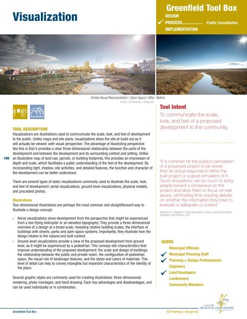
Visualization - The Greenfield Tool Box
Visualization - The Greenfield Tool Box
Visualization - The Greenfield Tool Box

Create successful ePaper yourself
Turn your PDF publications into a flip-book with our unique Google optimized e-Paper software.
<strong>Visualization</strong>› Three-dimensional rendering» Advantages: a single three-dimensional model can be used for multiple visualizations;the model can be based on existing geographic data for rapid creation; advanced lightrendering processes can improve the realism of the output» Disadvantages: highly detailed models require a significant amount of time andcomputing power to produce› Photo-montage» Advantages: fairly quick, depending on skill with image processing software such asAdobe Photoshop; can draw directly from photos of multiple precedents» Disadvantages: unedited photos from multiple sources can conflict visually if colors orresolutions are vastly differentThree-dimensional renderingCredit | O2 Planning + Design Inc.› Hand-drawing» Advantages: lends a “human-touch” to the visualization» Disadvantages: detailed drawings require significant time and skill to producePhotos of Precedents and Best PracticesPhotos, illustrations, or video of existing precedents and best practices can communicate thescale, look, and feel of design elements or schemes in places that already exist. This is aneffective way to supplement low-detail visualizations, highlight particular features, and showthe inspiration for a proposed design.Physical Scale ModelsPhysical scale models of the proposed development provide the viewer with a tangible feelof the relative scale and depth of the site design. While not commonly used for large-scalegreenfield community design proposals, a simple physical scale massing model can showthe spatial nature of a design in a way that static illustrations or images of 3D models orcannot. Physical models are commonly constructed from balsa wood, foam core, cardboard,or plastic. <strong>The</strong>se models might be highly detailed but can be expensive, and are not oftenmodified after created. Interactive models using blocks or Legos have also been used ininteractive design exercisesPhoto montageCredit | O2 Planning + Design Inc.107WHEN IN THE PROCESS IT IS USED?Site Planning and DesignWhile most of the site planning and design process is performed in two-dimensions on mapsand plan view drawings, three-dimensional sketching can explore how different designconcepts might be perceived from the ground. Sketching out preliminary visualizations canallow the planner, designer, or developer to understand the design complexities that mayaffect the function of the development.Public Consultation<strong>Visualization</strong>s help to provide the community with information about how a proposeddevelopment will fit into a community. <strong>The</strong>y illustrate the subtle urban design characteristicsthat make a place out of a project. <strong>The</strong>y can support meaningful discussion of the proposal bythe public. By coupling visualizations with maps, metrics, and performance indicators, theyhelp the public gain a complete understanding of the project.It is important to note, however, that visualizations are tools for communicating ideas. Assuch, the degree of skill exhibited in executing the visualization can impact how the idea isperceived or understood. Effective visualizations will allow ideas to be readily understood,but a poorly executed visualization confuses an audience or have a negative effect on theperception of the design concept.Hand-drawingCredit | Urbsworks Inc.Physical modelSource | Katz, Peter. <strong>The</strong> New Urbanism: Toward an Architecture ofCommunity. New York: McGraw-Hill, Inc. 1994. p. 36<strong>Greenfield</strong> <strong>Tool</strong> <strong>Box</strong>O2 Planning + Design Inc.
<strong>Visualization</strong>BEST PRACTICESAvoiding MisrepresentationIn the conceptual phases of site planning anddesign, it can be difficult to provide an accuratedepiction of what a site could look like beyond apurely artistic illustration. All participants shouldbe aware that the content and level of detailshown in a conceptual design can perceivedliterally, although it may misrepresent how adesign would look in reality. This is importantin a public process, as a misleading imagepresented to the public during consultation canimpact public trust in the process and decreasethe credibility of the proposal.LOCAL APPLICATIONSAirdrie Visual Representation of Land UseLOCAL APPLICATIONSMahogany, CalgaryBefore | After Culture Hub106Before | After Sensitive AreaCredit | O2 Planning + Design Inc.Mahogany, CalgarySource| www.mahoganyliving.comRELATED TOOLSBuild-Out AnalysisCharretteForm-Based CodeSmart CodeVisual Preference SurveyADDITIONAL RESOURCESSheppard, Stephen R. J. Visual Simulation: A User’s Guide for Architects, Engineers, and Planners. New York: Van Nostrand Reinhold, 1989.Google Sketch Up – free 3D modelling software (http://sketchup.google.com/)<strong>The</strong> Ultimate List of Online Color <strong>Tool</strong>s (http://www.webdesignbooth.com/the-ultimate-list-of-online-color-tools-for-web-developers/)<strong>Greenfield</strong> <strong>Tool</strong> <strong>Box</strong>O2 Planning + Design Inc.