Walkability Audit - The Greenfield Tool Box
Walkability Audit - The Greenfield Tool Box
Walkability Audit - The Greenfield Tool Box

Create successful ePaper yourself
Turn your PDF publications into a flip-book with our unique Google optimized e-Paper software.
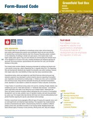
<strong>Walkability</strong> <strong>Audit</strong><br />
<strong>Greenfield</strong> <strong>Tool</strong> <strong>Box</strong><br />
DESIGN<br />
PROCESS.................. Evaluation Metric<br />
IMPLEMENTATION<br />
66<br />
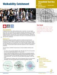
TOOL DESCRIPTION<br />
<strong>Walkability</strong> is a measure of the conditions of an area that promote walking. A walkable<br />
community offers a safe and pleasant pedestrian experience, with accessible destinations<br />
and desirable amenities. <strong>The</strong>re are distinct health, environmental, community, social, and<br />
economic benefits associated with more walkable communities over settlements with more<br />
limited opportunities for walking.<br />
A walkability audit examines and evaluates the walking (and in many cases, cycling)<br />
environment in a neighbourhood. Several different types of audit methods can be used, some<br />
of which can be found online. <strong>The</strong>se methods can help identify the concerns of pedestrians<br />
about the safety, access, comfort, and convenience of the walking environment, such as<br />
the width of sidewalks or location of crosswalks. Some audit tools assess the amenities<br />
and services within a certain radius of a location to provide a walkability score for a<br />
neighbourhood.<br />
An audit can also be used to identify potential alternatives or solutions to promote walking<br />
within a neighbourhood. This can include policy changes, education and enforcement<br />
measures, and site engineering treatments.<br />
<strong>Walkability</strong> Checklist<br />
One of the most common walkability audit tools is a checklist that can be used to assess<br />
different routes within a community. It can also be used when creating or revising plans for<br />
a proposed development to determine how successful the development will be in promoting<br />
walking and cycling.<br />
A checklist used for evaluating a the walkability of a development plan might ask:<br />
› Is there room to walk<br />
› Are there crossing aids for pedestrians and bicyclists to cross the street safely<br />
› Are there other street design characteristics to reduce volume or speed (e.g.,<br />
roundabouts)<br />
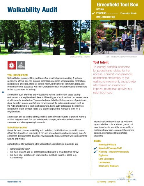
Credit | O2 Planning + Design Inc.<br />
<strong>Tool</strong> Intent<br />
To identify potential concerns<br />
for pedestrians related to the<br />
access, comfort, convenience,<br />
destination and safety of the<br />
walking environment, and provide<br />
alternatives or solutions to<br />
improve pedestrian activity in a<br />
neighbourhood.<br />
Informal walkability audits can be performed<br />
by any individual or local interest groups, but<br />
more formal audits should be performed by a<br />
multidisciplinary team composed of designers,<br />
planners, engineers and transportation<br />
specialists.<br />
USERS<br />
Municipal Officials<br />
Municipal Planning Staff<br />
Planning + Design Professionals<br />
Engineers<br />
Land Developers<br />
Landowners<br />
Credit | Walkable and Liveable Communities Institute<br />
Community Members<br />
<strong>Greenfield</strong> <strong>Tool</strong> <strong>Box</strong><br />
O2 Planning + Design Inc.
<strong>Walkability</strong> <strong>Audit</strong><br />
CASE STUDIES | BEST PRACTICES<br />
Walkable Edmonton<br />
<strong>The</strong> City of Edmonton developed an initiative in 2008 to<br />
provide expertise and resources supporting walkable design<br />
and advocacy for walkability. <strong>The</strong> City created a committee<br />
composed of a number of City Departments and external<br />
stakeholders, including the Edmonton Transit System, Alberta<br />
Motor Association, Alberta Centre for Active Living, Sustainable<br />
Transportation Department, Parks & Public Works, Edmonton<br />
Police Service, and Alberta Health Services. One of the key<br />
needs identified by the Committee was the development of an<br />
overall strategy to quantify walkability in the City and identify<br />
the actions required to reach a vision. Under this initiative, two<br />
documents were developed: the Proposed <strong>Walkability</strong> Strategy<br />
for Edmonton and Walkable Edmonton <strong>Tool</strong>kit.<br />
Example of a <strong>Walkability</strong> Checklist<br />
Credit | Edmonton Edmonton<br />
Source | Walkable Edmonton:<br />
http://edmonton.ca/transportation/cycling_walking/walkable-edmonton.<br />
aspx<br />
http://www.edmonton.ca/transportation/<strong>Walkability</strong>Strategy200909.pdf<br />
http://www.edmonton.ca/transportation/CommPeople/<br />
WalkableEdmonton<strong>Tool</strong>kit.pdf<br />
Source | http://www.walkscore.com/<br />
Online <strong>Walkability</strong> <strong>Audit</strong> <strong>Tool</strong> - Walk Score<br />
Another auditing approach is to evaluate what amenities and services pedestrians can access<br />
from their location. Walk Score is a website that demonstrates this approach by automatically<br />
calculating walkability at an address. To do this, it locates all stores, restaurants, schools, and<br />
parks accessible from the location. It provides a score from 0-100, with 90 or above denoting<br />
a location strongly oriented to walking. Scores below 25 identify sites that are strongly<br />
car-dependent, where travelling to any destination requires a car. While this is typically used<br />
to evaluate existing developments, the Walk Score approach can also compare the scores of<br />
communities that can provide the basis for the design of <strong>Greenfield</strong> development.<br />
WHEN IN THE PROCESS IT IS USED<br />
Most walkability audit tools are designed for reviewing existing environments. However, an<br />
audit can also be performed at different stages of the development of an area, including<br />
planning, design, and construction, to ensure that the spaces promote pedestrian activity.<br />
Most people are comfortable<br />
walking 400 metres (5 min) to a<br />
given destination, and depending<br />
on the circumstance or the walking<br />
environment, will walk up to 1,200<br />
metres.<br />
67<br />
POLICY SUPPORT<br />
Calgary Municipal Development Plan<br />
2.4.3 Enhancing the public realm - Policies<br />
a. Design streets and sidewalks to encourage pedestrian comfort, safety and linkages<br />
between neighbourhoods, open spaces and adjacent land uses.<br />
b. Safe pedestrian connections, transit shelters, bicycle parking, benches and clear<br />
wayfinding signage should be provided to facilitate all travel modes.<br />
c.Provide sufficient and uniform sidewalk width to allow for comfortable and safe pedestrian<br />
<strong>Greenfield</strong> <strong>Tool</strong> <strong>Box</strong><br />
O2 Planning + Design Inc.
<strong>Walkability</strong> <strong>Audit</strong><br />
traffic, the planting of trees and additional landscaping and wayfinding elements. Sidewalks<br />
should enhance the visual character of streets, with landscaping and buffer planting used to<br />
reduce the impacts of vehicle traffic.<br />
d. Promote a higher degree of attention to the architectural design and detailing of building<br />
edges in areas of interface with heavy pedestrian traffic, notably commercial streets such as<br />
Urban and Neighbourhood Boulevards (see CTP Section 3.7 – Complete streets).<br />
e. Consider seasonal factors when designing the public realm.<br />
f. <strong>The</strong> design of buildings, open spaces, pathways and parking areas should adhere to the<br />
principles of Crime Prevention Through Environmental Design (CPTED).<br />
g. Transit stations should be designed as vibrant, mixed use areas incorporating public<br />
gathering areas and public art.<br />
Town of High River Town Plan<br />
People and Housing Policies<br />
2.4.3.3 Increase transportation choices to and from, and walkability within, the town.<br />
Credit | Creative Commons | LUMIN8<br />
2.4.4.3 Require community and building design that promotes walkability and interaction<br />
between neighbours.<br />
2.4.4.6 Pedestrian sidewalks and pathways must be extended to each new community and<br />
employment area to ensure that a contiguous system is maintained.<br />
68<br />
Mobility Policies<br />
2.5.2.2 Provide safe pedestrian pathways and sidewalks that facilitate access to parks,<br />
natural features, employment zones and provide connectivity between neighbourhoods.<br />
2.5.2.3 Provide for the use and storage/parking of bikes, motorcycles, scooters, motorized<br />
wheelchairs, and other alternatives to the automobile in all new commercial, industrial and<br />
institutional developments.<br />
RELATED TOOLS<br />
Bikeablility <strong>Audit</strong><br />
<strong>Walkability</strong> Catchment<br />
Complete Streets<br />
Block and Lot Standards<br />
Traffic Calming<br />
ADDITIONAL RESOURCES<br />
Walkinginfo.org (http://www.walkinginfo.org/problems/audits.cfm)<br />
Alberta Centre for Active Living (http://www.centre4activeliving.ca/)<br />
<strong>Walkability</strong> Checklist (http://katana.hsrc.unc.edu/cms/downloads/walkability_checklist.pdf)<br />
Tolley, Rodney, Sustainable transport – Planning for walking and cycling in urban environments, Woodhead Publishing Ltd, 2003.<br />
<strong>Greenfield</strong> <strong>Tool</strong> <strong>Box</strong><br />
O2 Planning + Design Inc.