here - Risk Prediction Initiative - Bermuda Institute of Ocean Sciences
here - Risk Prediction Initiative - Bermuda Institute of Ocean Sciences
here - Risk Prediction Initiative - Bermuda Institute of Ocean Sciences

You also want an ePaper? Increase the reach of your titles
YUMPU automatically turns print PDFs into web optimized ePapers that Google loves.
Request for Proposals – North Atlantic Tsunamis<br />
North Atlantic tsunamis have exhibited a low frequency; however, tsunamis have been documented to<br />
occur, which could generate catastrophic losses along Atlantic coastlines today (Baptista et al, 2011).<br />
Tsunami Hazard assessments for various regions have been made based on historical data, with a view<br />
to protecting life, and estimating economic damage to property and infrastructure (Dunbar and Weaver,<br />
2008; Leonard et al, 2012). However, the complexities <strong>of</strong> tsunami inundation dictate that multiple scales<br />
be examined via numerical simulation when trying to assess the potential damage footprint (Lynnett<br />
and Liu, 2011) for catastrophe risk modeling purposes.<br />
Adding to the complexity <strong>of</strong> tsunami risk is the potential for submarine landslide events to trigger<br />
tsunami inundation (ten Brink et al, 2007) without an accompanying earthquake (the peril with which<br />
tsunamis are <strong>of</strong>ten paired in catastrophe models). Referring to catastrophe risk modeling, Lotz and<br />
Schmiesing (2012) state that “no vendor model currently exists for quantifying tsunami risk.”<br />
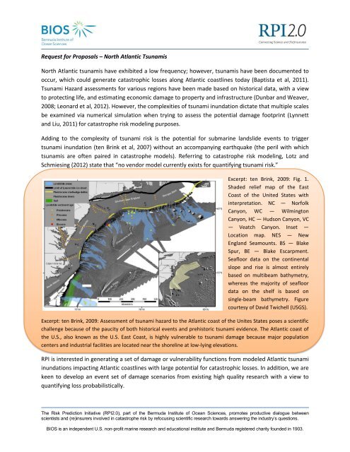
Excerpt: ten Brink, 2009: Fig. 1.<br />
Shaded relief map <strong>of</strong> the East<br />
Coast <strong>of</strong> the United States with<br />
interpretation. NC — Norfolk<br />
Canyon, WC — Wilmington<br />
Canyon, HC — Hudson Canyon, VC<br />
— Veatch Canyon. Inset —<br />
Location map. NES — New<br />
England Seamounts. BS — Blake<br />
Spur, BE — Blake Escarpment.<br />
Seafloor data on the continental<br />
slope and rise is almost entirely<br />
based on multibeam bathymetry,<br />
w<strong>here</strong>as the majority <strong>of</strong> seafloor<br />
data on the shelf is based on<br />
single-beam bathymetry. Figure<br />
courtesy <strong>of</strong> David Twichell (USGS).<br />
Excerpt: ten Brink, 2009: Assessment <strong>of</strong> tsunami hazard to the Atlantic coast <strong>of</strong> the Unites States poses a scientific<br />
challenge because <strong>of</strong> the paucity <strong>of</strong> both historical events and prehistoric tsunami evidence. The Atlantic coast <strong>of</strong><br />
the U.S., also known as the U.S. East Coast, is highly vulnerable to tsunami damage because major population<br />
centers and industrial facilities are located near the shoreline at low-lying elevations.<br />
RPI is interested in generating a set <strong>of</strong> damage or vulnerability functions from modeled Atlantic tsunami<br />
inundations impacting Atlantic coastlines with large potential for catastrophic losses. In addition, we are<br />
keen to develop an event set <strong>of</strong> damage scenarios from existing high quality research with a view to<br />
quantifying loss probabilistically.<br />
The <strong>Risk</strong> <strong>Prediction</strong> <strong>Initiative</strong> (RPI2.0), part <strong>of</strong> the <strong>Bermuda</strong> <strong>Institute</strong> <strong>of</strong> <strong>Ocean</strong> <strong>Sciences</strong>, promotes productive dialogue between<br />
scientists and (re)insurers involved in catastrophe risk by refocusing scientific research towards answering the industry’s questions.<br />
BIOS is an independent U.S. non-pr<strong>of</strong>it marine research and educational institute and <strong>Bermuda</strong> registered charity founded in 1903.
Questions, objectives and scope <strong>of</strong> work<br />
Develop a set <strong>of</strong> realistic tsunami inundation scenarios, to a high resolution, for high exposure regions<br />
along Atlantic coastlines.<br />
Develop and provide a probabilistic mechanism for determining the proportion <strong>of</strong> earthquake-induced<br />
tsunamis and tele-tsunamis, vs. non-earthquake tsunami genesis (e.g. from local submarine landslides).<br />
Key components <strong>of</strong> this work will be:<br />
- A final report that details the results <strong>of</strong> the analysis. The final report should stress the thinking<br />
and rationale supporting the techniques that were used to analyze and clean the primary data<br />
as well as the final analysis <strong>of</strong> the finalized data set.<br />
- A dataset derived from the study which underpins any subsequent publications and/or code<br />
which may be used directly by RPI members prior to any resulting publication.<br />
This work should be completed by June 2014. The successful scientist(s) should plan to attend an RPI<br />
Research Update Workshop in <strong>Bermuda</strong> in 2014, with a view to a presentation <strong>of</strong> the results. The<br />
successful scientist(s) may also be requested to attend other RPI Members functions.<br />
Interested parties should submit a research proposal <strong>of</strong> no more than 5 pages that includes a budget.<br />
Proposals should be uploaded electronically via the following website:<br />
http://rpi.bios.edu/proposal_upload/upload.<br />
Previous RPI grant awards have generally been on the order <strong>of</strong> $50K/year. Award decisions are based on<br />
the scientific merit <strong>of</strong> the proposed research, the relevance <strong>of</strong> the research to the stated goals,<br />
development and availability <strong>of</strong> appropriate follow-on applications for our Members, and the dollar<br />
amount requested.<br />
Further information on the RPI is available at http://rpi.bios.edu/.<br />
Submissions deadline is May 15, 2013.
References<br />
Baptista, M. A., J. M. Miranda, R. Omira, and C. Antunes Potential inundation <strong>of</strong> Lisbon downtown by a<br />
1755-like tsunami, Nat. Hazards Earth Syst. Sci., 11, 3319–3326, 2011<br />
www.nat-hazards-earth-syst-sci.net/11/3319/2011/ doi:10.5194/nhess-11-3319-2011<br />
Dunbar, Paula K. and Craig S. Weaver, U.S. States and Territories National Tsunami Hazard Assessment:<br />
Historical Record and Sources for Waves, Prepared for the, National Tsunami Hazard Mitigation<br />
Program, August 2008 U.S. DEPARTMENT OF COMMERCE, National <strong>Ocean</strong>ic and Atmospheric<br />
Administration, U.S. DEPARTMENT OF INTERIOR, U.S. Geological Survey<br />
Leonard, L.J., G.C. Rogers, and S. Mazzotti, A Preliminary Tsunami Hazard Assessment <strong>of</strong> the Canadian<br />
Coastline, OPEN FILE 7201, GEOLOGICAL SURVEY OF CANADA, 2012, Natural Resources Canada.<br />
Lotz, L., and Schmiesing, Z., Frequent Changes to Catastrophe Models: The Far-Reaching Impact ,<br />
Emphasis 2012 - Issue 1, March 2012, Towers Watson,<br />
http://www.towerswatson.com/en/Insights/Newsletters/Global/emphasis<br />
Lynett, P., and Liu, P. L.-F. (2011) "Simulation <strong>of</strong> Complex Tsunami Behavior." Computing in Science and<br />
Engineering Magazine, July/August 2011, v. 13(4), pp. 50-57, doi: 10.1109/ MCSE.2011.22.<br />
ten Brink, Uri, Preface - Tsunami hazard along the U.S. Atlantic coast, Marine Geology 264 (2009) 1–3<br />
_____, David Twichell, Eric Geist, Jason Chaytor, Jacques Locat, Homa Lee, Brian Buczkowski, and<br />
Mylène Sansoucy (Atlantic and Gulf <strong>of</strong> Mexico Tsunami Hazard Assessment Group), The Current State <strong>of</strong><br />
Knowledge Regarding Potential Tsunami Sources Affecting U.S. Atlantic and Gulf Coasts - A Report to the<br />
Nuclear Regulatory Commission, USGS, 2007